ROAD EXTRACTION AND VECTORIZATION FROM AERIAL IMAGE DATA
←
→
Page content transcription
If your browser does not render page correctly, please read the page content below
The International Archives of the Photogrammetry, Remote Sensing and Spatial Information Sciences, Volume XLIII-B2-2020, 2020
 XXIV ISPRS Congress (2020 edition)

 ROAD EXTRACTION AND VECTORIZATION FROM AERIAL IMAGE DATA

 Lin Zhua), Yang Lib), *, Hideki Shimamuraa)

 a PASCO Corporation, Japan – luihnz7801@pasco.co.jp
 b International Institute for Earth System Science, Nanjing University, China - liyan@nju.edu.cn

 TCII-Photogrammetry

KEY WORDS: Road extraction, Vectorization, Aerial images, Digital Surface Model, Morphology

ABSTRACT:

The objective of this study is the automatic extraction of the road network in a scene of the urban area from high resolution aerial
image data. Our approach includes two stages aiming to solve two important issues respectively, i.e., an effective road extraction
pipeline, and a precise vectorized road map. In the first stage, we proposed a so-called all element road model which describes a
multiple-level structure of the basic road elements, i.e. intersection, central line, side lines, and road plane based on their spatial
relations. An advanced road network extraction scheme was proposed to address the issues of tedious steps on segmentation,
recognition and grouping, using the digital surface model (DSM) only. The key feature of the proposed approach was the cross
validation of the road basic elements, which was applied all the way through the entire procedure of road extraction. In the second
stage, the regularized road map was produced where center line and side lines subject to parallel and even layout rules. It gives more
accurate and reliable map by utilizing both the height information of the DSM and the color information of the ortho image. Road
surface was extracted from the image by region growing. Then, a regularized center line was modeled by linear regression using all
the pixels of the road surface. The road width was estimated and two road side lines were modeled as the straight lines parallel with
the center line. Finally, the road model was built up in terms of vectorized points and lines. The experimental results showed that the
proposed approach performed satisfactorily in our test site.

 1. INTRODUCTION urban areas, there is a problem that many shadows cast by high-
 rise buildings on the side of the road, which significantly changes
Automated creation and update of road maps from high the color tone of the road surface. In addition, various factors
resolution remote sensing data is one of the most important and such as image acquisition conditions, trees, and moving objects
challenging researches in the field of photogrammetry and affect the results of road area extraction. In addition to the color
remote sensing. Detailed and up-to-date road map information is information of the image, a method that combines the height
necessary for a number of practical applications such as urban information of the DSM data with the color information of the
planning, transportation management, automotive navigation, image has also been studied by some researchers (Grote et al.,
disaster emergency response, and GIS related applications, etc. 2012; Hu et al., 2004; Jung et al., 2006). DSM provides height
Road extraction from remote sensing data has been studied for data of each terrain cell, which is useful for direct classification,
many years (Grote et al., 2012; Lu et al., 2014; Ubukawa et al., or segmentation of the off-terrain objects and the ground.
2014; Zhao et al., 2011). Although various automated
methodologies have been developed in order to obtain more Given that there are so much good road extraction methods like
accurate road maps, quite a lot of challenges still remain due to what we introduced above, we would still like present this study
the complexity of the environments in dense urban areas. Hence, that is novel on a complex vector road model as well as the
there is a great demand for development of corresponding new according extraction and vectorizing method. First, we proposed
strategies on automated road map creation. a so-called all element road model which describes a multiple-
 level structure of the basic road elements, i.e. intersection, central
For road extraction using remote sensing images, the methods line, side lines, and road plane based on their spatial relations. An
used and the information that can be extracted vary greatly advanced road network extraction scheme was proposed to
depending on the resolution of the images. When using low address the issues of tedious steps on segmentation, recognition
resolution (
The International Archives of the Photogrammetry, Remote Sensing and Spatial Information Sciences, Volume XLIII-B2-2020, 2020
 XXIV ISPRS Congress (2020 edition)

 height of the flat zones using the average height of the DSM to
 remove building areas. Some operations such as hole filling is
 implemented to the result and the ground is generated.

 2.1.3 Extraction of street block envelopes
 Street block refers to an area surrounded by streets, usually
 containing two rows of houses or several buildings. For these
 blocks, a Delaunay triangulation method is applied to obtain their
 envelopes as single pixel curves. A block’s outline can be
 represented by an envelope, which should be close to its out
 extent and in a smooth shape. Here we choose the convex hull to
 represent the outline. The convex hull is the maximal alpha shape.
 The advantage of convex hull are as follows: it is unique and
 independent of any parameters because of the characteristics of
 Delaunay triangular; the lines of the hull are straight which can
 be used to create straight central lines in the following stages.

 2.1.4 Extraction of candidate road center line
 The center line in this stage is the contingent single pixel width
 image object. It is going to be used as the seeds of accurate road
 surface extraction in the next stage. Because of the complexity of
 the real world, the extraction of road center lines has to follow
 some cross validation process.

 In order to extract the candidate road center line, a distance image
 of ground flat areas is generated by using distance transform
 method, where the distance is defined as the shortest one of a
 Figure 1 Flow chart of the proposed road extraction method pixel in a region to its boundary. Therefore, a pixel which is
 farther away from the boundary have a larger value. The road
 2. METHODOLOGY center line consists of pixels with the local maximum values of
 the distance image. The generated distance image is used to
The proposed road extraction approach includes two stages, extract the candidate road center line by a watershed image
which aim to solve two important issues respectively, i.e., an segmentation.
effective road extraction pipeline, and a high precision vectorized
road map. The details are described as follows. 2.1.5 Determination of road center line, road side lines,
 and road intersections
2.1 Extraction of road elements Road center lines, road side lines and road intersections are
 determined by a cross validation from each other. First, image
In the first stage, we proposed a so-called all element road model morphological dilation was performed to the candidate road
which describes a multiple-level structure of the basic road center lines and got the road polygons Pr, and the overlayed parts
elements, i.e. intersection, central line, side lines, and road plane of the blocks’ envelope curves with Pr were extracted as
based on their spatial relations. An advanced road network candidate road side lines. Next, we performed image
extraction scheme was proposed to address the issues of tedious morphological dilation again to the candidate road side lines and
steps on segmentation, recognition and grouping, using the got the side line polygons Ps, and extracted the overlayed parts
digital surface model (DSM) only (Li et al., 2016). Figure 1 of the candidate road center line with Ps as the road center line.
shows the flow chart of the proposed road extraction method. An Here, the road center line is intermittent because the road
overview of the analytical process is summarized below. intersections have not yet been extracted.

2.1.1 NDSM generation It is necessary to extract road intersections in order to connect
NDSM is obtained from the difference between DSM and DTM. intermittent road center lines. To extract a road intersection, first,
First, we use DSM data to generate DTM by applying an image a 5×5 template is moved along the candidate road center line. A
morphological opening processing to remove ground objects candidate intersection is extracted if there are more than 7 pixels
such as buildings, trees, and mobile objects. Next, NDSM is of the candidate road center line inside the template. Since some
generated by differential processing between DSM and the of the extracted candidate intersections are mis-extracted, the
generated DTM. extracted road center line is used to remove road intersections
 that are not adjacent to the road center line. From the vertices of
2.1.2 Extraction of ground flat areas all extracted road center lines, an expansion is performed along
Image morphological processing is applied to the generated the candidate road center lines. When it hits an intersection, the
NDSM to extract the so-called flat zones of a set of pixels with expansion is stopped. If the expansion does not hit the
the same height and adjacent to each other. Flat zones are firstly intersection even after expanding at a pre-defined distance, the
extracted as the ground’s basis. It refers to a connected region of expansion is stopped and the expanded part is also discarded.
the DSM, in which all the pixels have the same gray-level (i.e. Finally, the road center line, road side lines, and road
height). Gray levelling and labelling are implemented to extract intersections are all determined.
the flat zones. To avoid extracting rough objects, the approximate
flat zone is introduced that use a parameter to filter the small area
zones. A parameter is defined to permit the height difference
within a zone. Ground flat areas are extracted by thresholding the

 This contribution has been peer-reviewed.
 https://doi.org/10.5194/isprs-archives-XLIII-B2-2020-1323-2020 | © Authors 2020. CC BY 4.0 License. 1324
The International Archives of the Photogrammetry, Remote Sensing and Spatial Information Sciences, Volume XLIII-B2-2020, 2020
XXIV ISPRS Congress (2020 edition)
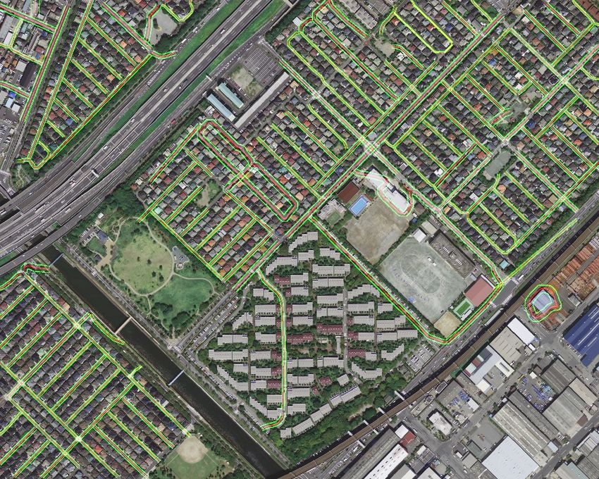
2.2.1 Generation of region growing seeds
The seed points were selected every certain interval from the road
center line extracted in the first stage. We first partition the center
line in a certain interval, ex. 10 pixels, then we label the
regions of the center line sections as the seeds. Figure 3 shows
the generated seed points.
Since the color and height of some road surface slightly changes
in some places, the initial seed points for a road are expected to
be singular and separate pixels instead of a whole line. The
deviation of the color and height of the pixels on such a line
would be greater than that of any neighborhood of a singular
point which would cause a region grow to some unwanted pixels.
2.2.2 Generation of region growth control data
We were not employing region growing to segment the whole
image into various semantic regions. The seeds were only of road
surfaces, and the desired regions would be only of road regions.
In case the regions grow to other types of land cover pixels, a
controlling measurement has been introduced in the growing
algorithm. The RGB image was converted to a grayscale image
and edge extraction was performed using a Canny edge filter
Figure 2 Flow chart of vectorized road map production (Canny, 1986). In addition, the green index G/(R+B) is used to
extract the vegetation areas. The edge pixels and the vegetation
2.2 Production of vectorized road map pixels were extracted from the image and taken as the barrier for
the road surface. If a neighbor pixel is a barrier, the algorithm
The objective of our study in the second stage was to produce the will not put it into possible growing neighbor.
vector road map where center line and side line is regularized as
straight line, with paralleled spatial relationship and parametered
distance.
In the first stage, the basic road elements were obtained from the
DSM of lower resolution and less accurate than the image. In this
stage, the road surface can be extracted more accurately and
reliably by utilizing both the height information of the DSM and
the color information of the ortho image. For that, we a)
generated seeds from the first stage’s center lines, b) extracted
road surfaces from the image by region growing, c) linear
regressed a more precise center line accordingly using the pixels
of a road surface, d) estimated the road width by the distances of
the extremes of the road and created the side lines. Finally, the
road model was built up in terms of vectorized points and lines.
Figure 2 shows the flow chart of the vectorized road map
production. The detailed stepwise implementation procedure is
described as follows.
Figure 4 Region growth results
2.2.3 Region growth of the road area
The road surface was grown using the hue information obtained
by converting the RGB image into HSV color space, and the
height information of the DSM data which expressed by equation
(1). The thresholds for region growing were set to a hue of 0.5
and a height of 0.5 m. The result of region growth is shown in
Figure 4.
= ∪ { | , , } (1)
∈ , ∉ , ∉
= ( ) − ( ) < 0.5
= ( ) − ( ) < 0.5
Here, refers to region j as a set of pixels. Refers to a
Figure 3 Generated seed points pixel. ( ) refers to the neighborhood of region . refers
to the edge pixel set. refers to the vegetation pixel set.
This contribution has been peer-reviewed.
https://doi.org/10.5194/isprs-archives-XLIII-B2-2020-1323-2020 | © Authors 2020. CC BY 4.0 License. 1325The International Archives of the Photogrammetry, Remote Sensing and Spatial Information Sciences, Volume XLIII-B2-2020, 2020 XXIV ISPRS Congress (2020 edition) 2.2.4 Regularization of road center line road side lines were modeled as the straight lines parallel with A morphological processing was applied to the road intersections the center line, and evenly locate in its both sides in a distance of extracted in the first stage, which were used to segment the grown half road width. The regularized road central line and side lines road region into road sections. Then, the road center line for a are shown in Figure 6, respectively. section was modeled as a straight line and the associated parameters were calculated by linear regression taking all the 3. RESULTS pixels in that section into consideration. The large amounts of samples in linear regression will introduce a bit computation The study area is a densely built-up area in the Chiba, Japan. In burden but will produce most reasonable center line without this area, there are a variety of building types such as detached possible deviations by random sampling. For a dataset of huge houses, apartments, tall condominiums, schools, factories, parks, extent, it is recommended to do random sampling to reduce the ballfields, waterways, railways, and parking lots. The roads data size for regression. include slightly wider ones among large building blocks, and narrower ones among smaller building blocks, and elevated highways. The aerial images are acquired by a multi-line digital airborne sensor ADS40. The orthoimages and DSMs data are generated by the Pixel Factory photogrammetric system. The resolution of DSMs is 0.5m and that of orthoimages is 0.2m. Figure 7 shows the road regularization result of the study area. It can be confirmed that the center line and side lines of the general roads have been correctly extracted across the whole study area. The elevated highways in the upper left of the study area have not been extracted. Since elevated roads, like buildings, have a height relative to the ground, their extraction needs to be studied in the future. Figure 5 Extracted side boundary (red ones) and extreme points (yellow ones) Figure 7 Road area extraction results of the study area 4. CONCLUSIONS There is no doubting that automated creation and update of road maps is very important for urban planning, transportation management, automotive navigation, disaster emergency Figure 6 Regularized road central line (red) response, and GIS related applications. In this study, we present and side lines (green) an automated road extraction and modeling method using aerial ortho image and DSM data of urban areas. The extracted road 2.2.5 Regularization of road side lines center line, side lines and intersections were encoded and Due to the influence of the canopies of the sidewalk trees, as well vectorized during the procedure of road extraction. The as the shadows of buildings and telephone poles, the complete experimental results showed that our approach performed road surface may not be extracted at some places when using the satisfactorily in our test site. Our main contributions are as region growing method, which may result in inaccurate follows: calculation of road width and road side lines. In order to solve this problem, the points farthest from the road center line among We proposed a road network model including both line and area, points on the road surface boundary were selected as extreme represented by road central line, side lines, and intersections. points. Figure 5 shows the extracted side boundary and the They are self-contained and spatial relevant, and can be used in extreme points. Using the average distance of the extreme points reasoning. to the center line, the road width was calculated, and finally two This contribution has been peer-reviewed. https://doi.org/10.5194/isprs-archives-XLIII-B2-2020-1323-2020 | © Authors 2020. CC BY 4.0 License. 1326
The International Archives of the Photogrammetry, Remote Sensing and Spatial Information Sciences, Volume XLIII-B2-2020, 2020
 XXIV ISPRS Congress (2020 edition)

We presented a cross validation method for the road model, to Development Methodologies. Data Science Journal, 13, pp. 45-
remove the false intersections, false branches of the central lines. 66.

We proposed a model to generate road area map. The road model Wiedemann C., Ebner H., 2000, Automatic Completion and
can be built up in terms of vectorized points and lines. Evaluation of Road Networks, International Archives of
 Photogrammetry and Remote Sensing, Amsterdam, Netherland,
In the future, we will apply the developed method to more areas Vol. XXXIII, Part B3, pp. 979-986.
to verify the extraction rate. Also, we will assess the accuracy of
the road area extraction results in comparison with a real road Zhao J., You S., Huang J., 2011, Rapid Extraction and Updating
map, and thereby improve the method for better performance. of Road Network from Airborne LiDAR Data, Applied Imagery
 Pattern Recognition Workshop, IEEE, Washington, DC, USA,
 REFERENCES pp. 1-7.

Canny J., 1986, A Computational Approach to Edge Detection.
IEEE Transactions on Pattern Analysis and Machine Intelligence
PAMI-8 (6), pp. 679-698.

Doucette P., Agouris P., Stefanidis A., Musavi M., 2001, Self-
organised clustering for road extraction in classified imagery,
ISPRS Journal of, Photogrammetry & Remote Sensing, 55, pp.
347-358.

Doucette P., Agouris P., Stefanidis A., 2004, Automated Road
Extraction from High Resolution Multispectral Imagery,
Photogrammetric Engineering & Remote Sensing, 70(12), pp.
1405-1416.

Grote A., Heipke C., Rottensteiner F., 2012, Road Network
Extraction in Suburban Areas, The Photogrammetric Record,
27(137), pp. 8-28.

Hu X., Tao C. V., Hu Y., 2004, Automatic Road Extraction from
Dense Urban Area by Integrated Processing of High Resolution
Imagery and LiDAR Data, The International Archives of the
Photogrammetry, Remote Sensing and Spatial Information
Sciences, Istanbul, Turkey. Vol. XXXV, Part B3, pp. 288-292.

Jung W., Kim W., Youn J., Bethel J., 2006, Automatic Urban
Road Extraction From Digital Surface Model And Aerial
Imagery, ASPRS 2006 Annual Conference, Reno, Nevada
Nevada, pp.654 654-663.

Li Y., Wu J., Zhu L. and Tachibana K., 2016, Road Network
Extraction from DSM by Mathematical Morphology and
Reasoning, The International Archives of the Photogrammetry,
Remote Sensing and Spatial Information Sciences, XLI-B2, 715-
720, XXIII ISPRS Congress, Prague.

Lu B., Ku Y., Wang H., 2009, Automatic Road Extraction
Method Based on Level Set and Shape Analysis, Second
International Conference on Intelligent Computation Technology
and Automation ICICTA, vol. 3, pp.511-514.

Lu P., Du K., Yu W., Wang R., Deng Y., and Balz T., 2014, A
New Region Growing-Based Method for Road Network
Extraction and Its Application on Different Resolution SAR
Images, IEEE Journal of Selected Topics in Applied Earth
Observations and Remote Sensing, 7(12), pp.4772-4783.

Ravanbakhsh M., Heipke C., Pakzad K., 2008, Extraction of
Road Junction Islands from High Resolution Aerial Imagery
Using Level Sets, The International Archives of the
Photogrammetry, Remote Sensing and Spatial Information
Sciences, Beijing, China, Vol. XXXVII. Part B3a. pp. 131-138.

Ubukawa T., de Sherbinin A. M., Onsrud H., Nelson A. D.,
Payne K., Cottray O., Maron M., 2014, A Review of Roads Data

 This contribution has been peer-reviewed.
 https://doi.org/10.5194/isprs-archives-XLIII-B2-2020-1323-2020 | © Authors 2020. CC BY 4.0 License. 1327
You can also read