Estimating crop evapotranspiration of managed alpine grassland using remotely sensed LAI
←
→
Page content transcription
If your browser does not render page correctly, please read the page content below
Höhere Bundeslehr- und Forschungsanstalt für Landwirtschaft                                                      19. Gumpensteiner Lysimetertagung 2021, 17 – 24
Raumberg-Gumpenstein                                                                                                                    ISBN: 978-3-902849-83-0

Estimating crop evapotranspiration of managed
alpine grassland using remotely sensed LAI

Matevz Vremec1*, Andreas Klingler2, Markus Herndl2,
Andreas Schaumberger2 and Steffen Birk1

       Zusammenfassung
       Die Auswirkungen von Management und Pflanzenentwicklung auf die Verdunstung
       von Grünland (ETC) können mithilfe von Blattflächenindexmessungen (LAI) und
       Wuchshöhe (hcrop) geschätzt werden. Die Verfügbarkeit von satellitenbasierten
       LAI-Produkten verringert dabei den Bedarf an In-situ-Messungen. In dieser Studie
       haben wir die geschätzte ETC nach Penman-Monteith mit einer In-situ-LAI (Accu-
       PAR-ETAP) und einer Fernerkundungsmethode (Feldspektrometer-ETFS) auf einem
       Dauergrünland der HBLFA Raumberg-Gumpenstein verglichen. Der Vergleich von
       ETFS und ETAP mit dem Lysimeter (ETa) zeigt eine starke Korrelation und geringe
       Abweichungen zwischen den Ansätzen. Um unabhängig von In-situ-Messungen
       zu werden, haben wir eine Beziehung zwischen hcrop und LAI hergestellt. Auch
       diese Methode zeigt eine starke Übereinstimmung mit ETa . Aufgrund der breiten
       Verfügbarkeit empfehlen wir die Verwendung eines Fernerkundungs-LAI, um die
       Schätzung der Grünland- ETC auf Feldstücks- und regionaler Ebene zu verbessern.

       Schlagwörter: Evapotranspiration,                      Leaf     area      index,      Fernerkundung,
       Wirtschaftsgrünland

       Summary
       Impacts of management and crop development on crop evapotranspiration
       (ETC) can be estimated using measurements of leaf area index (LAI) and crop
       height (hcrop). Recent progress in retrieving LAI from remote sensing platforms
       diminishes the need for in situ LAI measurements. In this study, we compared
       the estimated Penman-Monteith ETC using LAI of an in situ (AccuPAR-ETAP) and a
       remote sensing method (field spectrometer-ETFS) on a managed grassland at AREC
       Raumberg-Gumpenstein. Comparing ETFS and ETAP with lysimeter (ETa) showed a
       high correlation with little deviations between the two approaches. To become
       independent of in situ measurements, we established a relationship between hcrop
       and LAI to estimate ETc-remote. We observed a much better agreement of ETc-remote
       with ETa than that of the FAO reference ET0 . Because of the open access and the
       wide availability, we encourage the use of remotely sensed LAI to improve the
       estimation of managed grassland ETC on a plot and regional scale.

       Keywords: Evapotranspiration, Leaf area index, Remote sensing, Managed
       grassland

Introduction
Permanent grassland covers about 50% of the total agriculturally used area in Austria
and is used either for livestock grazing, is sustainably managed, or is left abandoned
(BMLRT 2020). As such, understanding water-related processes in mountain grassland is
of high importance for the agricultural and energy sectors (Schaumberger et al. 2008).

1
    Institute of Earth Sciences, University of Graz, 2 Institute of Plant Production and Cultural Landscape, Agricultural
    Research and Education Centre Raumberg-Gumpenstein, Irdning-Donnersbachtal
* Ansprechpartner: Matevz Vremec, email: matevz.vremec@uni-graz.at

                                                                      19. Gumpensteiner Lysimetertagung 2021                                                 17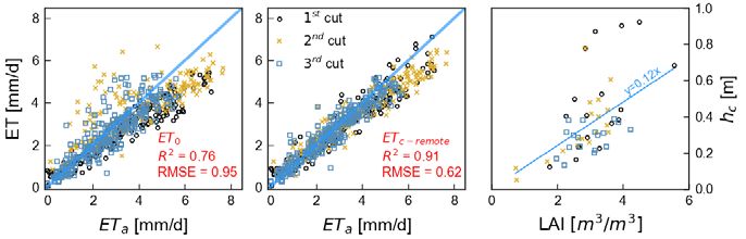
Crop evapotranspiration (ETC) plays a significant role in grassland water budgets,
     especially in managed grassland, where the crop vegetation stage highly affects ETC .
     The Penman-Monteith equation, recommended by the Food and Agriculture Organiza-
     tions (FAO), includes the effect of crop development and management practices on ET,
     by including the leaf area index (LAI) and crop height (hcrop) in the calculation of the
     surface and aerodynamic resistances (Allen et al. 1998). As in-situ measurements of
     LAI are very scarce, laborious and expensive, remote sensing products are increasingly
     used) to monitor the changes of grassland development due to management activities
     or abiotic effects (droughts) (Darvishzadeh et al. 2008). Recent studies have shown a
     high correlation between direct respectively indirect in-situ methods and proximal and
     remotely sensed LAI-data (Klingler et al. 2020).
     This study compares the LAI measurement method‘s influence on estimating ETC of
     a managed permanent grassland. Estimated values of ETC are compared with actual
     evapotranspiration (ETa) values of a high precision lysimeter, managed according to the
     surrounding grassland (3-cut system).

     Material and methods

     Study area
     The study was conducted at the test site at the Agricultural Research and Education
     Centre Raumberg-Gumpenstein in Austria (707 m above sea level) (Pötsch et al. 2019). The
     experiment is equipped with high precision weighable lysimeters, which offer a unique
     opportunity to study soil water fluxes of permanent grassland. The dominant species
     at the experimental site are Arrhenatherum elatius, Dactylis glomerata, Taraxacum offi-
     cinale and Lotus corniculatus. The agricultural management of the grassland lysimeters
     corresponds to the regional management of the surrounding grassland at Gumpenstein,
     which includes three cuts per year and a fertilization intensity of 90 kg nitrogen, 65 kg
     phosphor and 170 kg potassium per year (Herndl et al. 2011).

     Penman-Monteith equation
     The Penman-Monteith equation is regarded as a standard method for estimating crop
     evapotranspiration (Monteith 1965) using measured meteorological (radiation, tempe-
     rature, humidity, wind) and crop specific data (LAI and hcrop). Evapotranspiration of a
     reference crop can be estimated following the FAO-56 methodology (Allen et al. 1998),
     diminishing the need for crop phenological data. ETC and ET0 were calculated on a daily
     basis after recommendations by FAO (Food and Agriculture Organization) (Allen et al.
     1998):

                                                                             1

     The ET0 is derived from equation 1, assuming a constant grass height of 12 cm, LAI=hcrop
     · 24 and rs of 70 (sm-1):

                                                                             2

     where ETC, ET0, Rn and G are in MJm-2 d-1; ∆ is the slope of the saturation vapor pressure
     temperature relationship (kPa°C-1); ρa is the air density (kg m -3), cp is the specific heat of
     air (MJkg−1°C−1); γ is psychrometric constant (kPa°C-1); ra and rs are the aerodynamic and
     surface resistances (ms-1), respectively. ra and rs are calculated using linearly interpolated
     data of LAI and crop height (hcrop) measurements:

18   19. Gumpensteiner Lysimetertagung 2021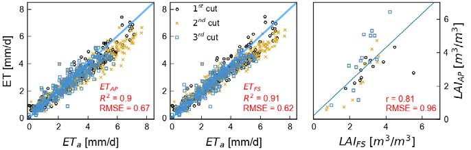
3

where d is the zero plane displacement, zm and zh are heights of the wind and humidity
measurements (m), respectively, uz the wind speed ad height z (ms-1) and k is the von
Karman constant (0.41). Surface resistance is calculated (rs) as:

                                                                           4

where rl is the bulk stomatal resistance of the vegetation (= 100 ms-1), and LAIact the
active leaf-area index, which accounts for heat and vapor transfer occurring only in the
upper half of the canopy (LAIact =LAI · 0.5).

Field Data Collection of LAI
Indirect in-situ LAI measurements were performed in triplicate using the AccuPAR
LP-80 Ceptometer (Decagon Devices Inc., Pullman, WA, USA). This linear quantum
sensor measures the photosynthetically active radiation above and below the canopy
and calculates the LAI using models that combine the radiation measurements with
canopies-architecture related variables and sun position information (Meter 2018). The
field spectrometer HandySpec Field VIS/NIR 1.7 field spectrometer (tec5 AG, Oberursel,
Germany) was used to measure hyperspectral canopy reflectance in the range from
400 to 1690 nm. The measurements were carried out between 10 a.m. and 2 p.m. under
as constant and cloudless conditions as possible, at four areas within the lysimeter. In
addition to spectral reflectance measurements, the average crop height is collected on
the plots using ultrasonic sensors. The measurements described above yielded the two
independent estimates of the leaf area index LAIAP and LAIFS, respectively.

LAI Retrieval Algorithm
The ESA‘s Spectral Response Functions were used to convert the hyperspectral signature
from the HandySpec into the corresponding S-2 bands (ESA, 2018). Subsequently, the
LAI was calculated using a neural network algorithm that was trained with radiative
transfer simulations and specifically tailored for Sentinel-2 data (Baret et al. 2010). The
missing S-2 band 12 was calculated according to (Klingler et al. 2020). All transforma-
tions and calculations were performed using the SpectroAnalyst tool (Schaumberger
and Adelwöhrer 2020).

Lysimeter data
Measurements of the C0T0 high precision weighable lysimeter, representing the un-
treated reference plot in the Lysi-T-FACE experiment (Herndl et al. 2011), were used
for this study. The lysimeter has a surface area of 1 m² and a depth of 1.5 m. It is
equipped with time-domain reflectometry probes that measure the soil water content
at different soil depths. Soil water contents at 30 cm depth were standardized using
the Soil Moisture Anomaly Index SMAI as defined by Jiménez-Donaire et al. (2020) and
employed to identify severe drought periods, during which actual evapotranspiration
is expected to be lower than potential crop evapotranspiration. The raw lysimeter data
underwent manual and automated plausibility checks and were post-processed using
the adaptive window and threshold filter AWAT (Peters et al. 2017). The actual evapo-
transpiration ETa is calculated from the water balance equation on a 10 min resolution
following Schrader et al. (2013).

                                                    19. Gumpensteiner Lysimetertagung 2021    19
Results
Comparing crop ET with Lysimeter ET
The crop evapotranspiration (ETc) is according to Allen et al. (1998) „the evapotranspiration
from disease-free, well-fertilized crops, grown in large fields, under optimum soil water
conditions, and achieving full production under the given climatic conditions“. To compare
the lysimeter-obtained evapotranspiration with the estimated ETc, days with potential
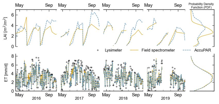
water stress were excluded from the analysis. Figure 1 shows the effect of water stress
on ETa . (An apparent effect of water stress is observed over the summer of 2019, with
low SMAI values and a higher (Estimation of ETc using an LAI/hcrop relationship
A relationship between LAI and hcrop was obtained by fitting a simple linear function y =
k*x to the ultrasonic crop height data from the lysimeter plot. As the ETFS data showed a
better agreement with the lysimeter ETa, we only used LAIFS data for the fitting process.
5
where hcrop is obtained crop height in m. Using LAIFS and the above-derived relationship,
ETC-remote was estimated. Over the entire observed period results similar to ETFS were
obtained, thus showing that ETC-remote of managed grassland can be successfully estimated
without the need for crop height data. In Figure 4, which shows the relationship between
LAIFS and hcrop, we can observe that the derived hcrop relationship underestimated higher
hcrop values in the first cut, which lead to higher RMSE values of ETC remote in the first
cut (Table 1).
Conclusions and outlook
This study used LAI measurements of the AccuPAR indirect optical method and the pro-
ximal (field spectrometer) remote sensing approach to estimate crop evapotranspiration
observed at a field weighable lysimeter. Estimated ETc values were compared to lysi-
meter-obtained ET over the period 2016-2019. Comparing the estimated ETAP and ETFS
with ETa, showed a high agreement with both methods, considering r and RMSE. A high
correlation (r>0.85) was observed between the LAI values for the first and second cut,
whereas the LAI slightly deviated on the third. No larger deviations of ETFS and ETa were
observed in the first cut, whereas a higher RMSE of the ETAP was observed in the second
and third cut. To estimate ETC independently of in situ measurements, a relationship
was established between LAI and hcrop . The estimated ETc-remote exhibited similar values
to ETFS and outperformed ET0, thus providing an accurate method to estimate ETc using
remotely sensed crop data. Recent studies showed a good agreement between proximal
(field-spectrometer) and satellite remote sensing data (Sentinel-2), thus providing an
opportunity to expand these findings on a regional scale.
Figure 2: LAI values and estimated crop evapotranspiration with a corresponding probability density function.
19. Gumpensteiner Lysimetertagung 2021 21Figure 3: Crop evapotranspiration of ETAP and ETFS compared to lysimeter ETa and the correlation between LAIFS and LAIAP.
Figure 4: Estimated FAO re-
ference ET0 , ETc-remote and the Acknowledgements
relationship between LAIFS
and hcrop . This work is partly funded by the Earth System Sciences programme of the Austrian
Academy of Sciences (project ClimGrassHydro).
References
Allen R.G., Pereira L.S., Raes D., Smith M., others, (1998) Crop evapotranspiration-Guide-
lines for computing crop water requirements-FAO Irrigation and drainage paper 56. Fao
Rome 300, D05109.
Baret F., Weiss M., Bicheron P., Berthelot B. (2010) Sentinel-2 msi products wp1152 algorithm
theoretical basis document for product group b. INRA-EMMAH Avignon Fr.
BMLRT (2020) Grüner Bericht 2020 - Bericht über die Situation der österreichischen
Land- und Forstwirtschaft. Bundesminist. Für Nachhalt. Tour. Wien 297 S.
Darvishzadeh R., Skidmore A., Schlerf M., Atzberger C., Corsi F., Cho M. (2008) LAI and
chlorophyll estimation for a heterogeneous grassland using hyperspectral measurements.
ISPRS J. Photogramm. Remote Sens. 63, 409-426.
ESA (2018) Sentinel-2 spectral response functions (S2-SRF).5 [https://earth.esa.int/web/
sentinel/user-guides/sentinel-2-msi/document-library/-/asset_publisher/Wk0TKajiISaR/
content/sentinel-2a-spectral-responses] (15.1.2020).
22 19. Gumpensteiner Lysimetertagung 2021Herndl M., Pötsch E.M., Bohner A., Kandolf M. (2011) Lysimeter als Bestandteil eines
technischen Versuchskonzeptes zur Simulation der Erderwärmung im Grünland.
Jiménez-Donaire M. del P., Tarquis A., Giráldez J.V. (2020) Evaluation of a combined
drought indicator and its potential for agricultural drought prediction in southern Spain.
Nat. Hazards Earth Syst. Sci. 20.
Klingler A., Schaumberger A., Vuolo F., Kalmár L.B., Pötsch E.M. (2020) Comparison of
Direct and Indirect Determination of Leaf Area Index in Permanent Grassland. PFG–Journal
Photogrammetry Remote Sensing Geoinformation Science 88 (5), 369-378.
McKee T.B., Doesken N.J., Kleist J., others, (1993) The relationship of drought frequency
and duration to time scales, in: Proceedings of the 8th Conference on Applied Climatology.
Boston, 179-183.
Meter (2018) AccuPAR PAR/LAI Ceptometer model LP-80: operator’s manual. Pullman,
WA, 81 S.
Monteith J.L. (1965) Evaporation and environment, in: Symposia of the Society for Expe-
rimental Biology. Cambridge University Press (CUP) Cambridge, 205-234.
Peters A., Groh J., Schrader F., Durner W., Vereecken H., Pütz T. (2017) Towards an unbia-
sed filter routine to determine precipitation and evapotranspiration from high precision
lysimeter measurements. J. Hydrol. 549, 731-740.
Pötsch E., Herndl M., Bahn M., Schaumberger A., Schweiger M., Kandolf M., Reinthaler
D., Schink M., Adelwöhrer M. (2019) Climgrass-ein innovatives Freilandexperiment zur
Klimafolgenforschung im Grünland. 21. Alpenländisches Expertenforum „Klimawandel
im Alpenraum-Auswirkungen auf Ökosystem Grünl. Dessen Bewirtsch. HBLFA Raum-
berg-Gumpenstein Irdning-Donnersbachtal.
Schaumberger A., Adelwöhrer M. (2020) SpectroAnalyst – Management von Hyperspektral-
daten für die Grünlandforschung. Presented at the 40. Wissenschaftlich-Technische
Jahrestagung der DGPF, Deutsche Gesellschaft für Photogrammetrie, Fernerkundung
und Geoinformation e.V.,Band 29, Stuttgart, 184-196.
Schaumberger A., Eitzinger J., Formayer H. (2008) Räumliche Modellierung der potenziellen
Evapotranspiration, in: Paper Presented at the AGIT-Symposium, Salzburg.
Schrader F., Durner W., Fank J., Gebler S., Pütz T., Hannes M., Wollschläger U. (2013)
Estimating precipitation and actual evapotranspiration from precision lysimeter measu-
rements. Procedia Environ. Sci. 19, 543-552.
19. Gumpensteiner Lysimetertagung 2021 23You can also read