HANDBOOK 2019 EVENT - Oscars 100
←
→
Page content transcription
If your browser does not render page correctly, please read the page content below
2019 EVENT
HANDBOOK

              Page 1 of 40
EVENT HANDBOOK
              CONTENT                                                           PAGE
              01. Welcome                                                       3
              02. Event Schedule                                                4
              03. The Course
                   - Overview                                                   5
                   - sections and notes                                         6–16
                   - expected timings                                           17–18
              04. Mapping & Navigation
                   - notes                                                      19–20
                   - tools – (Avenza Maps)                                      21
              05. Mandatory Equipment List                                      22–23
              06. Sleeping / Gear / Food logistics                              24
              07. Crew / Support / Course Access                                25–29
              08. Safety / First Aid / Communications                           30–32
              09. Crewing / Supporting More Notes                               33
              10. Rules                                                         34
              11. Alternative Course                                            35
              12. Oscars100 – About                                             36
              13. Oscars 100 Fundraising                                        37
              14. Accommodation / Mount Buller                                  39

                                                      CANCELLATION POLICY
PLEASE NOTE THE EVENT CANCELLATION POLICY, AS PER EVENT ENTRY CONDITIONS NOTED UPON ENTERING ONLINE.
Should the event be cancelled due to dangerous weather conditions – extreme heat (Code Red etc), cold, high winds, excessive rain
or other natural environmental danger, (or at the direction of Parks Victoria, DELWP, CFA or any other authority), there will be no
refund on entry fee.

We apologise in advance should this be the case, however the logistical factors involved in maintaining an event of this nature
(remote, high logistical load) means all funds will have been spent on non-refundable logistical concerns and materials prior to the
event. Thus, as with many other big ultra events in the Australian wilderness (think Bogong to Hotham, Alpine Challenge), the only
way we can offer the event is with the understanding that entry fees are forfeited by all entrants should an extreme weather event
occur, forcing late cancellation (i.e. week of event).

Attempts will be made to notify entrants as soon as possible should a cancellation occur; however, no responsibility is taken by the
organisers for lost travel, accommodation or entry expenses. On a Code Red Fire day, the race will be cancelled as in keeping with the
Risk Management Plan and Parks policy.

Given the logistics involved, it is not possible to set an alternative date.

CONDITIONS UNDER WHICH EVENT IS LIABLE TO BE CANCELLED:
Actual or predicted conditions inclusive:
- CODE RED fire danger rating - cancelled
- EXTREME fire danger rating – cancelled, decision in conjunction with fire authorities.
- SEVERE fire danger rating – potential for cancellation or use of alternative course pending consultation with fire authorities
- HIGH RAINFALL / HIGH WINDS / ELECTRICAL STORM – potential for cancellation or use of alternative course pending consultation
with authorities.

REFUNDS / DISCOUNTS
Should the race be cancelled due to a weather event, organisers will consider offering a 50% discount on an entry in the following
year’s event.

ALTERNATIVE COURSE – MARGINAL FOUL WEATHER
Should the weather conditions be borderline of cancellation, we will consult with regional emergency and land management
authorities. Should the consensus be that the event can proceed but under changed / safer course conditions we will enact an
alternative course, that consists of two 50km loops off Mt Buller, taking in Craig’s Hut. This course allows greater and more consistent
vehicular access to participants on course and thus allows for a quicker and safer evacuation should it be required. Participants will
be notified 72-48 hours prior to event day. No refunds can be given should you choose not to do the alternative course.

                                                                                                                             Page 2 of 40
01.
WELCOME
Welcome to Oscars 100 Hut 2 Hut run/trek and thanks for taking on what will be potentially a life-changing and life-
affirming challenge for you and certainly a life-changing event for those at the receiving end - families and children living
with autism.

The experience we have conjured for you amid the stunning Victorian High Country promises an adventure like no
other. You will complete a 100km course that loops off Mount Buller Resort and into the Alpine National Park. You’ll
journey mostly along single track, including spectacular sections of the Australian Alpine Walking Track (AAWT), along
with some 4WD trails, together linking together ten summits and nine of the State’s historical mountain huts (including
Craig’s Hut of The Man From Snowy River fame). And while the physical effort will be
big, it will be worth it as you raise funds and awareness for autism via the registered
autism charity and event host, Oscars100.                                                       THE NUMBERS
Touted by some as like an ‘Oxfam Trailwalker gone wild’, the physical and mental
challenge will require long days on the feet, the stamina to climb extended ascents,                                  55
and the nerve to run along steep ridgelines in remote country side. What makes this                       hours to finish
course so spectacular is the approx. 5600 meters of climbing that participants face –                         challenge
one of the most extreme on the trail running and trekker challenge event calendar.

Those participating as teams of two will face a 55-hour finishing cut off, choosing to                            100
stay either one night or two out on course in what we call ‘dark periods’, where the                           kilometres
racing takes a break. Those who have been selected as invitational solo runners, you
face a 16 hour cut off at the approx. 72km mark – lest you be re-graded into the
trekking category and spend a night at King Valley Hut!
                                                                                                               5600
                                                                                                       metres of ascent
Director of Oscars100 charity, Andy Payne, also an ultra runner and parent of two
sons living with autism, is hopeful that Oscars100 Hut2Hut will become known as one
of Australia’s ultimate endurance charity challenges, given its distance, terrain
                                                                                                                      10
covered and ascent profile.                                                                                       summits

“Oscars100 Hut2Hut is a great way to challenge yourself in a positive way, by
undertaking the 100km trek or run, participants are raising awareness and funds that
                                                                                                                         8
go towards support services for children living with autism,” says Andy.                                               Huts

“Our family is fortunate, thanks to early diagnosis and our ability to access private                                 10
therapy, our son (after who the charity was named) Oscar’s development has come a                    major checkpoints
long way,” says Andy. Oscar was diagnosed with autism in 2011 when his teacher was
brave enough to raise her concerns.
                                                                                                                         2
Oscars100 Hut2hut will be supporting Mansfield Autism Statewide Service, an                       layovers (trekker)
independent organisation, which supports young people, and their families who are
living with Autism and Irabina who provide family-centred early intervention programs and services to children and
families impacted by Autism Spectrum Disorder.

We hope you enjoy the challenge. Remember – it will be difficult, you will get tired, and there will be moments when
you wonder “Why am I doing this?” That’s where you look up, enjoy the view, the camaraderie of those out on course
with you, and the riches of an experience that will push your boundaries. That’s when you dig deep and keep going –
imagining the satisfaction you will feel once you have summited Mt Buller in the tail end of the course (for the second
time!), and crossed the line, exhausted, but full of achievement. And of course, Oscars100 and all the families that are
touched by autism, will thank you. In 2018, Oscars100 raised over $50,000, most of which was through Oscars100 Hut 2
Hut, and which will be used to purchase a car for Mansfield Autism Statewide Service, allowing their specialists to get
out to remote regional areas to assist families impacted by autism. This is what you guys help achieve! You changed
these family’s lives!

Cheers, Andy and Michelle Payne, Jared, Matt, Lucas, Chris and the Hut 2 Hut organising team.
Oscars100 is endorsed as a Deductible Gift Recipient (DGR) Charity by the Australian Charities & Not for Profit
Commission. Charity ABN: 2472 1965542

                                                                                                                  Page 3 of 40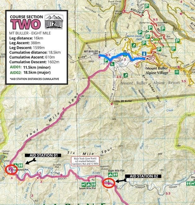
02.
EVENT GENERAL SCHEDULE
DATE       TIME         ACTIVITY                                                                           LOCATION
THURSDAY   2pm –        Hut2Hut Registration                                                               Buller Cinema,
14TH       7.00pm*                                                                                         Lower floor,
FEBRUARY   late check                                                                                      Main
           ins can be                                                                                      Administration
           processed                                                                                       Building (stairs
           post Race                                                                                       down out
           Briefing.
                                                                                                           front)
           From         Pre-race Dinner * Prior Bookings required. Tickets must be paid for prior to       Abom
           5:30pm -     Feb 5th.                                                                           Restaurant,
           7.00pm       https://www.registernow.com.au/secure/Register.aspx?E=33349                        Athletes Walk,
                        Sittings are 5.30pm and 6.00pm                                                     Buller Village

           7:15pm       Hut2Hut Event Briefing – This is a mandatory briefing. We cannot stress how        Buller Cinema,
                        important it is to attend this briefing.                                           Lower floor,
                                                                                                           Main
                                                                                                           Administration
                                                                                                           Building (stairs
                                                                                                           down out
                                                                                                           front)
FRIDAY     4am          Late Race Check Ins                                                                Alpine Plaza,
15TH                    *ONLY IF PRE-ARRANGED WITH RACE MANAGEMENT                                         Buller Village
FEBRUARY                                                                                                   Square (start
                                                                                                           line)
           5:00am       Hut2Hut START                                                                      Buller Village
                                                                                                           Square
           2pm          Cut off - trek participant sleepover at Lovicks Hut // 37.5km/10 hours.            Lovicks Hut
           3pm          Cut off - AAWT turn off approx. 41km                                               AAWT Turn Off
           5pm          Cut off - Gantner Hut                                                              Gantner Hut –
                                                                                                           emergency
                                                                                                           layover
           8pm          Cut off - Speculation CP                                                           Speculation CP
                                                                                                           – 500m past
                                                                                                           Mt Speculation
                                                                                                           – emergency
                                                                                                           layover
           From         Hut2Hut solo + team run finishers                                                  Buller Village
           8pm –                                                                                           Square
           2am
           9pm          Cut off – participant sleepover at King Valley Hut // 71.5km/16 hours.             King Valley Hut
                        *qualification for solo run category following year = teams must pass
                        through prior to 9pm.

SATURDAY   from         Participants back on course Lovicks/King Valley. Leave huts for next leg. All      Lovicks Hut /
16TH       5am          participants MUST leave hut site by 6am latest. We suggest earlier.                King Valley Hut
FEBRUARY

           From         Hut2Hut trek finishers                                                             Buller Village
           8am -                                                                                           Square
           midnight
           6pm          Cut off - trek participant sleepover #2 at King Valley Hut // 71.5km /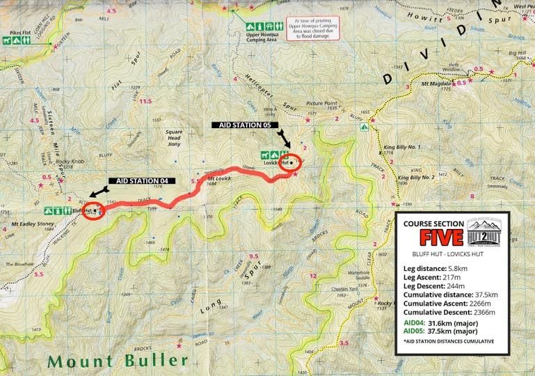
From          Hut2Hut trek finishers                                                        Buller Village
                 8.30am                                                                                      Square
                 12 noon       Hut2Hut trek finishers cut off                                                Buller Village
                                                                                                             Square
                 2pm           close

REGISTRATION & BRIEFING:

It is mandatory to present for REGISTRATION 2pm – 7pm on THURSDAY 15th at Buller
Cinema, located downstairs at Buller Main Administration Building (turn right at T-Junction as you
arrive on the mountain) WITH ALL YOUR MANDATORY GEAR FOR CHECKS.
It is mandatory to attend RACE BRIEFING at 7.15pm on THURSDAY 15th at Buller Cinema, located
downstairs at Buller Main Administration Building.

YOU MUST CARRY ALL MANDATORY GEAR WITH YOU AT ALL TIMES WHILE ON THE COURSE.
THERE WILL BE GEAR CHECKS EASH DAY AND YOU WON’T BE ABLE TO PROGRESS IF YOU”RE NOT
CARRYING THE MANDATORY GEAR

03.
THE COURSE: OVERVIEW
Google Map: https://drive.google.com/open?id=1JQt9DcJR9zP5bhYbGHvGJ5q4x1I&usp=sharing

Distance: 100km
Elevation: approx. 5600m

Beautiful she may be, the Hut 2 Hut course is, quite simply, a bit of a brute. Over 100km various GPS units
will come up with different results, but our instruments recorded in the vicinity of 5600 metres of gain. Ten
peaks will be bagged. Not big by world standards – indeed Buller itself is the highest at 1805m – but try
knocking off ten of them in a row, with plenty of diving down to the valley floor before climbing back up and
you will know you’ve worked hard.

Here’s the overview playbook:

Course Order: Buller Village > Buller Summit (1805m) > Four Mile (CP at bottom) > Eight Mile (CP) > Refrigerator Gap
(CP) > The Bluff (1725m) > Bluff Hut > Mt Lovick (1648m) > Lovicks Hut (CP) > AAWT turn off (CP) > Mt Magdala
(1725m) > Hells Window > Big Hill (1668m) > Mt Howitt (1742m) > Gantner Hut (out and back CP) > Viking Wilderness/
Crosscut Saw (1706m) > Mt Buggery (1608) > Horrible Gap > Mt Speculation (1666m) > MT Speculation CP > Muesli Spur
> King Valley Hut (CP) > Craigs Hut (CP) > Geelong Grammar Hut (CP) > Mt Stirling (1749m) > Howqua Gap Hut (CP) > Mt
Buller Summit (1805m) > Buller Village finish.

Checkpoints:
    •   11.5km > Howqua River / bottom of Four Mile (minor)
    •   18km > Eight Mile Flat (major)
    •   25km > Refrigerator Gap (minor)
    •   32km > Bluff Hut (major)
    •   37.5km > Lovicks Hut (major CUT OFF #1 > 2pm day 1)
    •   Turn off to AAWT (minor) 40.5km
    •   Turn off to Gantner Hut 49km (marshals only)
    •   50km > Gantner Hut (minor > overnight mandatory emergency stop post 5pm, release @ 5am day 2)
    •   59km > Mt Speculation Car Park (major)
    •   71.5km > King Valley Hut (major – CUT OFF# 9pm Day 1 + 6pm Day 2)
    •   78km > Craigs Hut (minor)
                                                                                                          Page 5 of 40
•   83km > Geelong Grammar Hut (minor)
    •   87.5km > Howqua Hut (major)
    •   97.5km > Buller Summit (tear page from book as proof of ascent)
    •   100km > Finish – Buller Village Square (major)

*A NOTE ON DISTANCE / ASCENT / DESCENT:
The distance / ascent / descent statistics have been gathered from numerous course recce runs (full loops),
using measurement instruments inclusive of Garmin handheld, Garmin Fenix 3 wrist unit and Suunto
Ambit2/3 units. Data was collated and sections judged most accurate from each chosen and integrated into
an ‘edited course’ using Garmin Basecamp. There will be some inconsistencies over any 100km course. All
distances are listed as indicative only, the major GPX file download on the website has incorrect ascent data
(7000+ metres! Which we can assure you it isn’t).

                                                                                                     Page 6 of 40
SECTIONS OVERVIEW

                    Page 7 of 40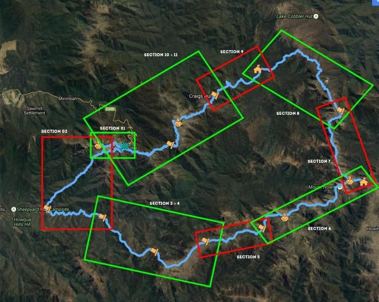
SECTION ONE
VILLAGE START – MT BULLER
Runners and trekkers begin at the Buller Resort Village (which will also be the finish). From the central courtyard, it’s a dash up the guts of Athlete’s Walk, past the
supermarket and accommodation buildings and Abom, hitting the main road. Follow that until you hit Arlberg Hotel on your left. Opposite is a car park and a small
wooden arch. Follow the trail that leads under that (Summit Nature Walk trail). It takes you to near the Northside Discovery Centre, where you will veer left across a
road and onto singletrack past Burnt Hut Reservoir, eventually leading you to the base of the Buller Summit. Look up – and step up. It’s an out and back to the Summit
proper (approx. 300 metres).

                                                                                                                                                                  Page 8 of 40
SECTION TWO
MT BULLER – EIGHT MILE
From the summit of Mt Buller, it’s a bomb back down, swinging to
the right, hooking up with a dirt road, which drops you down to a
bend. Don’t hug the road, which sweeps left. Leave it. Yep, on that
corner you’re turning right, going down into the bush. Follow the
ribbons into it, scrambling down some super rocky and technical
terrain as you make your way down Four Mile, a ridge that will
lead you 8km and 1300+- vertical meters down to the Howqua
River. Be careful in the first section, it’s easy to get off track –
which is not well defined – and suddenly find yourself sliding off
the ridge. There are big rocky sections early on – hard to run if
you’re trying to. We won't lie - this is perhaps the trickiest section
of bush as it's tight, scratchy, and not an obvious trail. The trail
gets more defined the further down you go (after 4km), weaving in
and out of tee tree stands higher up, getting tight in some patches.
There is a magnificent viewpoint early on where you scramble atop
a rocky outcrop (PLEASE TAKE CARE HERE AND DO NOT TRY TO
OVERTAKE AT THIS POINT). After that it’s back into the bush and
down, down, down, the trail getting much more trottable as you
get nearer the river. Watch your footing – there is a lot of ground
scrub and fallen debris / sticks, so it is easy to trip. You’ll pop out at
the river – cross over and pick up the trail (dart in to see Gardiners’
Hut (private) to the left if you like, but the challenge trail hooks to
the right just before the hut clearing and leads up to where you
will find an Aid Station, make sure you turn right and get checked
off at the first checkpoint before you head off on the main trail).
After the Aid Station, follow the single-track sidling east along the
river for 3.5km before popping up and out onto the gravel road
that is Brocks Road. Follow Brocks for 1.8km, until you see a turn
off left to Seven Mile Creek/Flat. Turn down towards the river and
follow the road/path until you pick up some single-track at the
back of the camp area (you are heading east). The single-track will
lead you to emerge at a bend in the access road to Eight Mile Flat.
Continue on ahead, making your way to the Eight Mile Flat camp
ground and first major aid station.

                                                                             Page 9 of 40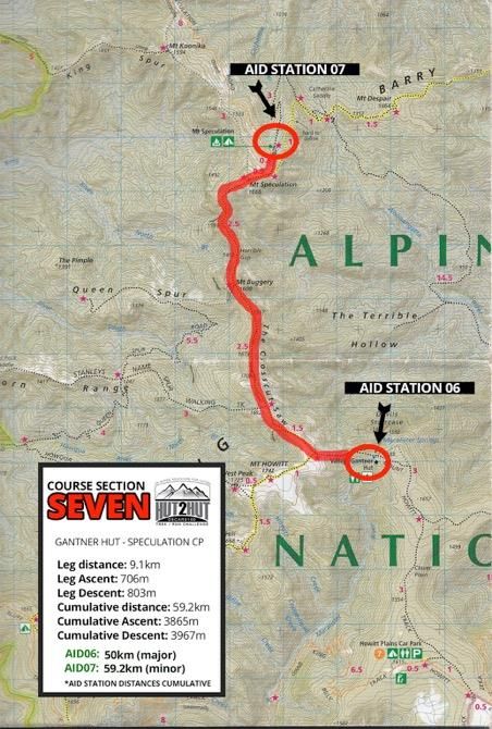
SECTION THREE
EIGHT MILE –
REFRIGERATOR GAP
At the Eight Mile Checkpoint,
get your huff’n’puff on as you
have a 5km section rising a
whopping 850m vertical
metres. Be sure to spin around
every so often to take in the
views back to Mt Buller.
Nearing the top, you will swing
east onto Rocky Ridge, a
beautiful pasture of knarled
gums and great views across to
the Bluff (deep breath, you
climb that soon). Follow the
trail that soon swings right
meeting with Bluff Link Road.

SECTION FOUR
REFRIGERATOR GAP
– BLUFF HUT
A marshal at Refrigerator Gap
will keep you on track – which
is to head directly up the road
(south east) for 900 metres
before turning off (veer right as
the road veers left) onto Bluff
Walking Track. Suck it up – you
now have a pinchy 1.5km/400
metre vertical ascent to the top
of the Bluff (1725m). From here
it is another 4.5km to Bluff Hut,
where you will meet the 4WD Bluff Track and a small aid station.
                                                                   Page 10 of 40
SECTION FIVE
BLUFF HUT –
LOVICKS HUT
A relatively straightforward section,
following (4WD) Bluff Track over Mt
Lovick (1684m) and on to Lovicks Hut,
a major aid station. Note that about
4.8km from Bluff Hut there is a
singletrack veering off to the left,
which shortcuts the road, leading to
Lovicks Hut. Take this trail – it is the
official course route! (why stay on
road when there’s singletrack?).
NOTE: No runner is allowed to pass
Lovicks Hut after 2:00pm on
Friday. Any runner wishing to
progress past Lovicks on Friday
16th MUST LEAVE BEFORE THE
2PM CUTOFF. Any runners not out
of the checkpoint by the time the
sweeps leave at 2:00PM will be
required to camp the night.
Page 11 of 40SECTION SIX
LOVICKS HUT – AAWT – GANTNER HUT
From the refresher of Lovicks, it’s a little further on
the 4WD track – check a few of the viewpoints
along this stretch – they are special and take in
pretty much all of the huge loop you are trying to
get around, all the way back to Buller, which on a
clear day you will spy! Approximately 3km along
Bluff track, you will come to a marshalled turnoff
onto the Australian Alpine Walking Track (AAWT).
NOTE: after leaving AAWT the next major aid
station is approximately 18km, so please ensure
you are fully stocked with water and supplies for
this section prior to leaving AAWT
Any runner wishing to progress past the AAWT
checkpoint on Friday 15th must have left before
the 3:00pm cut off time. Any runners left at the
checkpoint, or yet to make it, once the timing
sweep has left cannot progress any further for the
day. Runners not through by 3pm must return to
Lovicks (with 4WD marshals okay) and commence
again the next morning from Lovicks!
Take AAWT trail left off the 4WD track and get
ready for potentially the best trail walking / running to be found in the State! Ahead is a series of peaks to be bagged and the famous ‘Crosscut Saw’ to be traversed. First
up, it’s Mt Magdala (1725m), on past Hells Window and up Big Hill (1668m). The rollercoaster continues, with Mt Howitt next up (1742m). Keep on the trail heading
north east (do NOT take the trail that heads back to West Peak and down Howitt Spur!). From Howitt it’s a single-track sweep to the turn-off to Vallejo Gantner Hut. It is
MANDATORY for all participants to take the out and back to Gantner, which is checkpoint only, with only emergency supplies stocked (it is a remote aid station, so we
can’t get enough supplies in for it to be a major aid station). *There is mobile reception at turn off to Gantner.
No runner is allowed to pass Gantner checkpoint after 5:00pm on Friday. Any runner wishing to progress MUST LEAVE GANTNER HUT BEFORE THE 5PM CUTOFF. If
not departed prior to 5pm runners will be required to emergency bivvy at Gantner Hut. They can leave at 5am the following morning.
Page 12 of 40SECTION SEVEN GANTNER HUT – MT SPECULATION CAR PARK
From Gantner, where you need to check in with our marshals, it’s back out to the main AAWT
trail (1.5km) and a right hand turn north up into the mighty Viking Wilderness Area and the jaw
dropping Crosscut Saw, a high, thin-wedge ridgeline that will have you hollering and whooping.
Simply awesome.
From Gantner, it’s 8.5km along the ridge, bagging Mt Buggery (1608m), via Horrible Gap to
eventually climb up Mt Speculation (1666m).
NOTE: there are some sections along this part of the course where the wilderness closes in,
gets a bit scratchy, there is some clambering and a few ‘big-step’ rock ledges to get up. Please
be extremely careful in this section – you are on a ridge so if you lose the course a little, stay
high and keep moving forward (better yet – get your mobile out, locate yourself on the Avenza
Map, and get back on course!).
Not more than 500 metres after the summit of Speculation, you will turn off the AAWT, taking
the trail left for another 500 or so metres to hit Mt Speculation Campsite and a small aid
station.
No runner is allowed to pass Mt Speculation checkpoint after 8:00pm on Friday. Any
runner wishing to progress past Mt Speculation on Friday 16 th MUST LEAVE BEFORE
THE 8PM CUTOFF. Any runners not out of the checkpoint by the time the sweeps
leave at 8:00PM will be required to camp the night (or choose to DNF).
Page 13 of 40SECTION EIGHT
MT SPECULATION CAR PARK –
KING VALLEY HUT
From the Speculation campsite /
aid station, follow the Speculation
Road which traverses Mustering
Flat (can you hear the echoes of
the pioneering horsemen!).
Run/trek for 7.6km from the
campsite before looking for the
left-hand turn, off the road and
down Muesli Spur Track. It’s
about to get fun and fast! This
single-track drops nearly 600
metres in 3.5km! Up top it’s
definitely scramble territory but
down lower it’s zoom, zoom,
zoom. At the bottom it’s another
kilometre in to the major aid
station at King Valley Hut.
NOTE: should you reach King
Valley Hut any time AFTER 8pm
Friday or 6pm Saturday, you will
be forced to stay here the night.
You will be allowed to leave again
at 5am. For RUNNERS, this
means you need to have run
71.5km in no more than 16
hours. For trekkers – well, enjoy
the campfire.
Page 14 of 40SECTION NINE
KING VALLEY HUT – CRAIG’S HUT
From King Valley, you may feel like you’re on the
home stretch with 28.5km to go. Don’t relax,
there’s some hard yards still to be done.
Out of King Valley Hut (you need to run into the
campsite, check in, before running back out the
way you came for a few hundred metres), you will
take an old 4WD trail after a small river crossing
on your right, and bang! Into a big climb. Feeling
those calves yet?
The 4WD track (nameless) will climb up towards
Peters Corner. But before you hit the that corner
and the main road, veer off to the right, up into a
single-track we call Bill’s Track. This cuts off some
of Circuit Road (take the single-track, trust us!).
Hitting Circuit Road (fairly well groomed 2WD
road), turn right and follow until the turn off to
Craig’s Hut. Climb left up Clear Hills Track for
about 1.5km before veering off right on a
singletrack – another shortcut that pops you out
in front of Craig’s Hut, as made famous in The
Man From Snowy River. Interesting fact: it’s a
great hut but indeed is a re-creation of a fake!
Craig’s Hut was only first built as a set for the
movie. It then became a tourist attraction, before
burning down and being rebuilt.
Cut offs @ Craigs Hut*:
Friday: 10.30pm
Saturday: 7.30pm
Sunday: 7.30am
*It is imperative that you keep moving at a decent speed – trekkers inclusive – hence these cut offs are to ensure you stay ahead of an overall DNF.
Page 15 of 40SECTION TEN
CRAIG’S HUT – MT STIRLING
Having savoured the faux (but representative)
history of Craig’s Hut, it’s time to keep
moving. Head to the car park off to the south
west and take the 4WD trail that is Clear Hills
Track. It’s a stunning track with some beefy
climbs that will lead you all the way to the
exposed Mt Stirling. As you pop out onto
Stirling flanks keep on the main dirt road
sweeping around south – don’t head towards
Geelong Grammar School Hut (unless in an
emergency). At Mt Stirling (1749m) you are
required (for the fun of it) to head up to the
summit – a short 180m trek up – and back
before continuing your journey.
SECTION ELEVEN
MT STIRLING – HOWQUA GAP HUT
Coming off Mt Stirling, keep to the Howqua
Gap 4WD track that sweeps around to your
left. Follow it on an undulating 4WD trail that
starts to descend, eventually sweeping back
right and dropping sharply! Here there is a
bunch of switchbacks and wash out mounds.
Uncomfortable trekking or walking, as it is
steep, especially given you’ve got more than
80km in the legs! The 4WD trail weaves down towards your next (and final) hut: Howqua Gap Hut, where you pop out.
Cut offs @ Geelong Grammar / Stirling*: Cut offs @ Howqua Gap Hut*: *It is imperative that you keep moving at a decent speed –
Friday: 11.30pm Friday: 12 midnight trekkers inclusive – hence these cut offs are to ensure you stay
Saturday: 8.30pm Saturday: 9pm ahead of an overall DNF.
Sunday: 8.30am Sunday: 9am
Page 16 of 40SECTION TWELVE
HOWQUA GAP HUT – MT BULLER – VILLAGE FINISH
Nearly home you can feel it. But as you’d expect there’s a small task yet, in a gradual climb up Wooly Butt Spur towards Corn Hill (1630m). Note that you are now
following a MTB track called ‘Trigger Happy’. Nearing the top of Trigger Happy, you will you need to take a dog leg turn back to your RIGHT, on a double track that wends
its way down to join Cornhill Track. Once you hit Cornhill, ensure you turn SHARP LEFT (west) to continue on towards Mt Buller. Cornhill Track will eventually come to an
intersection where numerous MTB trails converge: Cornhill, Clancy’s Run, Delatite River, Picnic Trail and Wombat. Now, as we get closer to the Buller resort, it’s
important to get your thinking and navigation cap on as there will be more trails criss-crossing to confuse you!
Pick up Wombat Trail. This will lead you down into a small skills section of the MTB trail, before spitting you out, back over Corn Hill Road, and into another small skills
section. The trail will lead you on up a small gradient along Split Rock Trail. Keep sidling to the left, don’t take any of the trails coming in at you from the right. Split Rock
switchbacks up to join Family Trail, a flat, wide trail. Turn left and travel along, noticing the Buller Village just above you. Indeed, the finish line is within cooee here but
first you have one last trying task to complete – a return to the Summit from whence you came! (It’s all about laying down some tradition and ‘completing the circle). So
keep running along Family, until you are directed up what looks like a steep ski run (Because that’s what it is).
Follow signage until you pick up the southern section of the Summit Nature Walk. This leads to the car park at the bottom of Buller Summit. Up you go. Collect your
medal (we have to get you to prove you’ve been up there somehow!), and then head back down, this time veering left (north) along Summit Nature Trail, which is
following your footsteps from when you came up here last at the start of the challenge. Back past Northside Discovery Centre, back to the Arlberg (don’t stop for a beer
just yet), down the road to pick up Athletes Walk and the chute down into the Village Square and the FINISH!
Page 17 of 40THE COURSE: EXPECTED TIMINGS
Take your expected finish time and then add some! That’s the experience from last year’s inaugural running. As a guide, the
2017 WINNER, Mick Keyte, usually runs Ultra Trail Australia 100km in around 11 hours. He took 16.5hrs on Oscars100
course!
ARE YOU A RUNNING TEAM OR SOLO RUNNER?
Timings based on first runner from 2017 event No sleep over on course.
Fastest moving participant/s
> arrives bottom 4 Mile // 6.50am
> arrives 8 Mile // 7.30am
> arrives Refrigerator Gap // 8.50am
> arrives Bluff Hut // 10am
> arrives at Lovicks Hut post // 10.50am Friday ( arrives at King Hut post // 5pm Friday (12hrs total time 71.5km)
> arrives Craigs Hut // 6:50pm
> arrives Geelong Grammar Hut // 7.30pm
> arrives Howqua Gap Hut // 7.55pm
> arrives Buller // 9.30pm (16.5 hours total time for 100km).
Average mid pack moving run participant / no sleep over / approximations
> arrives at Lovicks post 12 noon Friday (two hours ahead of cut off)
> arrives at Kings post 8pm Friday (one hour ahead of cut off)
> arrives Buller post 1.30am Saturday
> LAST RUN PARTICIPANT due at Buller finish 2.30am Saturday.
ARE YOU A TREKKING TEAM?
Slowest moving trek participant:
> arrives at Lovicks post 2pm Friday (10 hour moving time for 37.5km) REST/SLEEP OVER leaves Lovicks 5am Sat
> arrives at Kings post 6pm Saturday (13 hours moving time for 34km) SLEEP OVER leaves Kings 5am Sunday
> Arrives Buller prior 12 noon cut off (7 hours moving time for 28km)
Slowest moving competitor: 30 hours moving time + 13hrs rest Lovicks + 9hrs rest Kings = 52 hours total on course (cut off
= 55 hours)
NOTES RE: runners:
There is one golden rule for competitors – cut offs are mandatory and non-stretchable!
NOTES RE: trekkers:
You will need to nominate where you expect to sleep over - be that Lovicks and King Valley or just Lovicks or King Valley.
Use the timings above to judge what your approach is, and have a plan! You are either planning on doing the course in
- up to two days (one sleep over - King Valley or Lovicks); or
- two and a half days (two sleep overs - Lovicks, then King Valley).
It is important you are realistic about making the judgment and devising your trek plan as our logistics revolve around it!
NOTES RE: trekker sleeping gear logistics: All trekkers will be required (mandatory) to carry own sleeping bag (lightweight
is fine) and sleeping mat. Plan your backpack choice carefully as you need to carry this around the entire course, along
with the other mandatory items and water. All competitors also need to supply their own tents, however tents will be
tagged and collected prior to the start of the challenge (at the Thursday briefing) and transported to the nominated sleep
over stations (so you do not carry your tents). Those sleeping over at Lovicks will then have their tents transported around
to King Valley for the second night, also. You can stash small items such as plates, personal cutlery etc in your tents so long
as it does not significantly increase the size of your tent bag!
Page 18 of 4004.
MAPPING &
NAVIGATION: NOTES
Oscars100 Hut2Hut takes place over a
distance of 100km with most of the
course passing through remote, thick,
challenging wilderness areas. This is an
adventure, after all.
You will travel along dirt roads (4WD /
2WD) for some stretches, while others
will be formal way marked trails, such
as the Australian Alpine Walking Track.
Others again are 'trails' in that they can
be found on maps, but as is the way
with the Australian bush, that doesn't
mean the way forward is obvious or
clear in many parts. Even the AAWT can get closed in with thick brush at times and there can be animal tracks leading off to
confuse (and signs aren't exactly prolific!).
To be clear, while we will be marking sections of the course and major intersections (only), we cannot and will not be
marking the course heavily with 'confidence markers' as you may find at a shorter trail run / walk event. You will need
have some confidence in being in the wilderness and keep your wits about you. You will need to think and make judgement
calls and minor navigational decisions (with major consequences). This is NOT to say that you need to be an expert
navigator or orienteering champ! You will be on gazetted trails, most of which have 'footfall markings' - that is, look down
and you will see clear signs of foot traffic having passed along the route. Plus, you will have read up on the course (won't
you?!).
What we are saying is that you need to know how to look at a map, recognise a trail, read topographical lines and generally
get a sense of where you are according to a map and more importantly, where you need to get to.
As mandatory for ALL COMPETITORS, you need to have on your person / team
1 Physical map of the course, preferably laminated and/or in waterproof slip. Self-supply. $12-15. See online
sales links below.
2 Mobile phone, with spare battery charge, pre-loaded with AVENZA MAPS APP with the course downloaded
into the App. The beauty of this system is that you don’t need regular phone reception for the map to
work including a locator beacon telling you where you are in relation to the marked course. So really,
you should never get off course – just turn on your phone, open the map within the App, and you can
see on a topographical map where you are in relation to the course (hopefully on it!). Self-organise.
FREE. SEE EVENT MANGER IF YOU CAN’T WORK IT OUT.
As optional you can also download the GPX file to upload (available on Hut2Hut website) on to your GPS-
enabled device (GPS handheld unit with AU map installed is best or use on your GPS-enabled watch (one with
tracking ability).
Page 19 of 40MAPPING & NAVIGATION: NOTES
ON COURSE MARKING: will consist of red 'Tour de Trails' arrows used at major turning points and sometimes pink and pink
reflective ribbons (although we will use this sparingly).
Sections on course to be mindful of as they will be the hardest to navigate:
3 Four Mile Spur (on course from approx 2.5km mark through to 10.5km). Difficult
terrain. No one will be running the first four kilometres. It is rocky
underfoot, steep and closed in bush. Be alert and do not drop off either
side of the spur. From approx 4km the going gets a little easier. But be
mentally prepared for slow going in this section.
4 Viking Wilderness Area (Cross Cut Spur)- (on course from approx 51km through
to 59km) mostly good and clear going, but as you get closer to Mt Buggery
and Mt Speculation, there are some sections where trail marking is
nonexistent, and bush closes in tightly (MT Buggery in particular). Another
good section to have your GPS Unit or mobile with Avenza open as you go.
5 Muesli Spur - (on course from approx 67 -through 71km) turning left down off Mt
Speculation 4WD road onto Muesli Spur Track, you will find some steep
sections. Again, check your bearing and use your navigation aids here,
especially if coming down in the dark.
Page 20 of 40MAPPING & NAVIGATION: TOOLS
These Hut2Hut course downloads are for course approximation and research purposes. They do show the true
route but the elevation data on the GPX is incorrect as the data consists of several tracks edited, a process that
has corrupted the true elevation values with some drop out.
The GPX can, however, be used to navigate on a GPX / GPS compatible unit.
- KML (for Google Earth)
- GPX files (useable on nav devices, Google Maps etc)
*use at your own risk.
You can DOWNLOAD THESE ON THE EVENT WEBSITE FOUND AT THE NAVIGATION page.
PHYSICAL MAPS MANDATORY
We suggest investing in the Outdoor Recreation series Buller-Howitt Alpine Area bushwalking map, 1:50,000,
published by SV Maps. They give a level of detail as seen on the course sections found on The Trails page of this
website. You can pre purchase this map today online via:
- Bogong Equipment
- Hema Maps
- Spatial Vision
You can carry the map as is, or we also recommend scanning (or photographing) relevant course sections,
printing out and laminating as easy-grab weatherproof cards.
AVENZA MAPS – mapping App for Oscars Hut 2 Hut MANDATORY
Once set up, the app works WITHOUT mobile reception, locating you on a 1:50,000 topo map. You need to
download the App onto your smartphone, then download the full high-res course map into the App.
Download the instructions as a PDF from the relevant link - print out if you need to:
• Apple
• Android
• Windows
MAP LINK FOR AVENZA
As per instructions in PDFs, you will need to copy and paste this link below (long press on top of the link & select
“copy”) to load the map into your Avenza App:
http://www.eventsafetyservices.com.au/eventmaps/oscars-100-hut-2-hut-v010218-1212hrs.tif
USING AVENZA MAPS
To make full use of Avenza maps, GPS must be turned on in your device.
• On the map, key locations are marked with yellow labels, and the route is marked as a semi-transparent blue line.
• The latitude and longitude numbers at the bottom of screen correspond to the point that the cross-hairs are
targeting at centre screen.
• Therefore, you can scroll around to any position on the map & determine the co-ordinates of the point between
the cross-hairs.
• Your current GPS location is displayed on the map as a blue dot.
Press the ‘Location Button’ to centre in on your current location. Once this is done, your current lat/long co-
ordinates will match the lat/longs displayed on the screen. This will only work if you are physically located within
the map boundaries.
Page 21 of 4005.
MANDATORY EQUIPMENT LIST
As this event will take you through the wilderness of Victoria’s Alpine region you will be required to carry, as a
minimum, a range of mandatory gear.
We have put together this list based on having average seasonal temperatures so please treat the mandatory
gear list as the minimum you should carry. It will be your responsibility to ensure you are best prepared for the
weather conditions. Weather in the Victorian Alps can change quickly so while you may only want to take the
lightest mandatory gear it may not be enough should it get cold.
Mandatory kit will be checked at race briefing, plus random checked throughout the event..
ALL (RUNNERS AND TREKKERS)
• suitable backpack for carrying items below
• PLB Beacon – supplied by event
• SPOT Tracker – supplied by the event
• Waterproof and windproof jacket with hood and sealed seams
• Waterproof and windproof pants with sealed seams
• Long sleeved thermal top and long johns (polypropylene, wool or similar). Cotton, coolmax, lycra and
any compression garment will not be acceptable
• Beanie/balaclava
• Windproof gloves
• Map of the trails, preferably 1:50,000 Buller-Howitt Alpine Area Outdoor Recreation Guide trekking map
by Spatial Vision. See NAVIGATION PAGE for where / how to buy online.
• Course notes (preferably laminated or in a waterproof map case or zip lock bag)
• Compass (must be manual compass) or GPS plus spare batteries for GPS. Find out how to use your map
and compass here.
• Lighter or waterproof matches
• Whistle (pea-less)
• Basic First Aid kit including: emergency space blanket or equivalent; Triangular bandage; personal
medicinal requirements; band aids / blister wraps; 10cm elastic bandage for snake bites/sprains. NB:
cotton crepe bandages are NOT acceptable.
(https://www.chemistwarehouse.com.au/buy/90006/snake-bite-bandage-10cm-x-10-5m)
• Fully charged mobile phone PLUS minimum 1x portable mini power bank (1 phone per solo runner/2
per team or relay team—Telstra provides the only coverage in patches).
• pre-loaded Avenza Maps App on your smartphone PLUS the course map downloaded into App. See
INSTRUCTIONS HERE for how to organise.
• Torch/headlamp PLUS spare batteries. Second back up headlamp preferred.
• Food—for the run and emergency food if lost
• Water carrying capacity —minimum 2-litres. More recommended if forecast is hot.
• Waterproof bag to keep your compulsory clothing dry (plastic bags/zip lock bags or dry sacks are fine)
• Sunscreen (roll on or tube)
REMINDER NOTE: As mandatory, you need to carry a mobile phone, with back up charge battery, with the
Avenza Maps App loaded PLUS the course map downloaded into App. See INSTRUCTIONS HERE for how to
organise.
Page 22 of 40MANDATORY EQUIPMENT LIST continued
TREKKERS ONLY (i.e. PLANNING TO STAY OVER AT EITHER OR BOTH LAY OVER HUT AID STATIONS)
• Trekkers only: second warmth layer top
• Trekker only: sleeping bag, lightweight
• Trekkers only: sleeping mat lightweight
• Trekkers only: other comfort items for overnight stay
The above items MUST BE CARRIED ON PERSON.
NOTE: trekkers will be required to supply own tent (two man for both team members), however you will
NOT have to carry it. Tents (only) will be transported out to your designated sleepover aid stations. So please be
realistic about where you are likely to sleep over. Those who are staying at the first (Lovicks), we will also
transport your tent around to Kings for your second night stop. We expect MOST teams will only stay over one
night (Friday) at Kings Hut. See our guide to expected timings to judge how you think you will fare.
INVITATIONAL RUNNERS ONLY: NON-CARRY MANDATORY
You are still required to bring and supply to organisers at registration a tent, sleeping bag and mattress. We will
take this to King Hut as emergency shelter should you not make cut off. This is MANDATORY.
ALL PARTICIPANTS: This gear won't be accepted so please don't include this in you mandatory gear
If you bring this equipment, and don’t have suitable mandatory gear, you will NOT be permitted to start until
you do.
• Water resistant jackets/over-pants
• Jacket without a hood
• “Skins” or equivalent are not acceptable as thermal top/bottom
• Non elasticised snake bite bandage less than 10 cm
Be Aware
There will be mandatory gear check at random checkpoints. If you are not carrying the mandatory gear you will
be detained at the checkpoint until you can access the required gear. If you cannot obtain the required gear you
will not be allowed to continue and you will be removed from the event. This list of equipment has been put
together to protect you and protecting you is something we take very seriously.
YOU MUST CARRY ALL MANDATORY GEAR WITH YOU AT ALL TIMES WHILE ON THE COURSE. THERE
WILL BE GEAR CHECKS EASH DAY AND YOU WANT BE ABLE TO PROGRESS IF YOU”RE NOT CARRYING
THE MANDATORY GEAR
Page 23 of 4006.
SLEEPING/GEAR/FOOD LOGISTICS
Do you have to carry your own sleeping bag and mat? YES. IF YOU ARE A TEAM ENTRANT. As with events like
the Marathon des Sables, due to the logistics of getting so much gear into very remote locations, we require trekkers
planning on staying either one night (King Valley) or two (Lovicks and King Valley), to carry their own lightweight sleeping
bag and mat. We suggest NOT taking your biggest, heaviest bag! Lightweight, compact bags are available at reasonable
prices. We don’t expect it to be too cold overnight, but let’s face it, this is a challenge and there is a chance you may not get
the best sleep you’ve ever had – but it’s not about being comfortable! Your bag, together with your clothing, only need
keep you warm enough to be SAFE! Not necessarily super comfy! Beside, you’ll be in a two person tent – snuggle. Worse
case, get your emergency space blanket (mandatory) out, and use it!
IF YOU ARE A SOLO INVITATIONAL RUNNER you still need to supply a tent, sleeping bag and mattress, but yours will be
forwarded to King Hut for emergency use only should you not make the 16hr cut off. Two-person teams – please do not
ask if your sleeping bag and mat can be forwarded also – the answer is no – if you qualify this year as a solo invitational,
you then get the benefit of not carrying sleeping bag and mat the following year!
Aren’t there huts to sleep in? There are huts, but they are not for sleeping in, officially. Should anything go awry, a
tent is lost or you feel you’d be warmer in the hut on a super cold night, of course you can sleep in the hut. But officially,
we need to sleep in tents and honestly, they are warmer and more comfortable than the often rat-visited huts anyway!
What about a tent? How does that work? YOU NEED TO SUPPLY YOUR TWO-PERSON TENT AT REGISTRATION,
ONE PER TEAM, with it clearly marked / tagged with your names, contact numbers and which sleepovers you are planning
on resting overnight at. This is so we can plan our transport logistics. YOU DO NOT HAVE TO CARRY YOUR TENT. We will
transport between stages and then back to the finish for pick up.
Can I send a drop bag of goodies / gear out on course? YES but ONLY to one or either of the sleepover aid
stations, and ONLY a small contained bag with your tent. We need to limit the number of bags / sheer volume as we only
have limited 4WD transport to get out on course and need to prioritise aid station gear. Drop bags are only for a little extra
food or clothing only, they are NOT for sleeping bags and mats, and they should be packed together with your tent in a
SMALL bag.
What will I eat out on course? The aid stations will have basic supplies supplied. Minor aid stations will have water,
some SOS Rehydration (coconut), lollies, muesli bars, chips, nuts, bread and spreads. The two major aid stations that are
overnight (LOVICK’S and KING VALLEY), we will supply some form of basic BBQ (sausages, burgers, vege burgers, noodles)
and basic cereals and UHT milk, tea and coffee. It won’t be gourmet, but we’ll do our best! You can use a drop bag to add in
any special food items you would like, but please note, it needs to be a small bag, clearly labelled and preferably
lightweight.
I’m a Solo runner – do I need to worry about sleeping bags, tents and mats? YES. As per above you still (as
mandatory) need to bring a sleeping bag, mat and tent. We will collect them from you at registration, and forward them to
King Valley as emergency supplies should you not make Friday night 9pm cut off. If this happens you will be required to stay
over at King Hut (or DNF if you want to go back to Buller).
DROP BAGS – limited to a 20L bag (small daypack) max, clearly marked with name and contact number, AND which
station you would like it dropped at. This must include your tent inside the bag.
There are only two places you can send a bag drop:
➢ Lovicks Hut (37.5km)
➢ King Valley Hut (71.5km)
Whilst all care and responsibility will be taken with drop bags, we suggest that you use something that is not overly
valuable and easily replaceable, as will not be responsible for any lost baggage (explanation: we rely on a huge team of
volunteers out on course and cannot micro-manage. Experience shows that while our vollies do an awesome job,
sometimes things go missing / astray purely because of the huge logistical effort involved, the sheer amount of equipment
and gear being transported, and we’re all only human. Dropbags and contents will not be replaced / compensated for.
Page 24 of 4007.
CREW / SUPPORT COURSE ACCESS (PLEASE NOTE PACERS ARE NOT
ALLOWEDON COURSE AT ANY STAGE – this is a lesson we learnt last year).
As Oscars100 is more about the doing than the winning, competitors can have crew assist on course. HOWEVER NOTE that
the majority of the course can only be accessed via fairly technical 4WD roads. We suggest, if you do intend having crew
meet you on course to resupply that the 4WD is suitable to the terrain – that is, an AWD will not suffice, nor in general will
a stock standard 4WD (i.e. tradie SUV / ute). We recommend a proper 4WD with high clearance and 4WD tyres as
minimum. Oscars100 and its contractors will not be held responsible for those crews attempting to access the course.
Those crews driving out on to the course do so at their own risk. If you get in trouble, you will be responsible for extracting
you and your vehicle. If our team is in the area and can help without impacting their responsibilities to the event and its
competitors, they will do so, however the primary responsibility for all volunteers, 4WD staff and event staff is to those
trekking and running in the event, and all priority will be afforded to them. We suggest that any driver willing to access the
course on the 4WD section be a proficient 4WDer with at least some experience in the field. Suggested crew meet ups are:
2WD ACCESS FROM SOUTH (PINK)
➢ Mt Buller (2km into course)
➢ Howqua River CP / bottom of Four Mile (11.5km into course)
➢ 8 Mile Flat CP (18km into course)
4WD ACCESS – FROM SOUTH (YELLOW)
➢ Refrigerator Gap (25km into course) - easy 4WD / All Wheel Drive i.e. a Subaru would get here
➢ Bluff Hut (32km into course)
➢ Lovicks Hut (37.5km into course) - serious 4WD
4WD ACCESS – FROM NORTH (YELLOW)
➢ Speculation Road Car Park (59km into course) - serious 4WD
➢ King Huts (71.5km into course) - easy 4WD / All Wheel Drive i.e. a Subaru would get here and we’ve proven an
Nissan XTrail can get in (the hard way even!)
➢ Mt Stirling (83km into course) - serious 4WD
2WD ACCESS FROM NORTH (PINK)
➢ King Huts (71.5km into course) - easy 4WD / All Wheel Drive i.e. a Subaru would get here and we’ve proven an
Nissan XTrail can get in (the hard way even!)
➢ Craigs Hut (78km remaining on course) / access to within 800m of Craigs Hut
➢ Howqua Gap Hut (87.5km into course)
➢ Mt Buller – village / summit
The following 2WD /
4WD access indicator
map and table with
Google Map links
shows base details
regards access. If you
intend driving out on
course (2WD Pink or
4WD Yellow sections)
you should have a
GOOD topographical
map that is up to
date for the region.
There is not always
phone GPS
connectivity out on
course so do not rely
on it soley.
Page 25 of 40COURSE KM DESCRIPTION ZONE ACCESS POINT/S VIA ROAD NOTES ACCESS MAP
BRACKET
0-3.5km Village - Summit – Four 1 Summit Road via Village Summit Road / dirt roads to 2WD 2WD + 4WD
Mile Drop off (Koflers Koflers Corner / Zwiers Zig
Corner / Zwiers Zig Zag) Zag
3.5km – 11km Four Mile - Gardiners 2 Gardiners Hut Buller Road > Howqua Track No crew access along 2WD + 4WD https://goo.gl/maps/gSgfPQN13g82
Hut > Sheepyard Flat > Brocks section. End of section
Road > Gardiners Hut only.
2WD to Gardiners Hut Aid
Station (bottom of Four
Mile)
11km – 18km Gardiners Hut – Eight 2 1.Gardiners Hut Buller Road > Howqua Track 2WD 2WD + 4WD https://goo.gl/maps/7Fa5iZFeLPE2
Mile Flat 2. along Brocks Rd > Sheepyard Flat > Brocks Several access points along
3. Seven Mile Road > Brocks Road. Participants
4. Eight Mile also use Broack Road as on
course for some stretches.
18km – 25.1km Eight Mile Flat – 3-4 1. Eight Mile Buller Road > Howqua Track No crew access on section. 4WD https://goo.gl/maps/TBXgkgKenXR2
Refrigerator Gap 2. Refrigerator Gap > Sheepyard Flat > Brocks 4WD Vehicle access only at
Road > Eight Mile Gap > Bluff either end of section.
Link Rd > Refrigerator Gap
25km – 32km Refrigerator Gap – Bluff 3-4 1. Refrigerator Gap Buller Road > Howqua Track 4WD only Refrigerator Gap 4WD https://goo.gl/maps/bH36SEwKvA42
Hut 2. Bluff Walking Track > Sheepyard Flat > Brocks to Bluff Hut. Access only at
Car Park Road > Eight Mile Gap > Bluff either end of course
3. Bluff Hut Link Rd > Refrigerator Gap > section (Bluff Track Car
Bluff Link Road > Bluff Track > Park + Bluff Hut)
Bluff Hut
32km – 37.5km Bluff Hut – Lovicks Hut 5 1. Bluff Hut Buller Road > Howqua Track 4WD Access to participants 4WD https://goo.gl/maps/Qn4xC1py8252
2. along Bluff Track > Sheepyard Flat > Brocks all section as they use Bluff
3. Lovicks Hut Road > Eight Mile Gap > Bluff Track 4WD trail between
Link Rd > Refrigerator Gap > Bluff Hut and Lovicks Hut.
Bluff Link Road > Bluff Track >
Bluff Hut > Bluff Track
37.5km – 50km Lovicks Hut via AAWT to 6 1. Lovicks Hut 1./2. Buller Road > Howqua 4WD Crew access only to 4WD https://goo.gl/maps/Emg2LvxkPeq
Gantner Hut** 2. Gantners Hut via Track > Sheepyard Flat > AAWT turn off. Condition
Howitt Plains Car Park Brocks Road > Eight Mile Gap of King Billy Track
**Gantner Hut remains (walk in 4.5km) > Bluff Link Rd > Refrigerator unknown.
an ‘access point’ for Gap > Bluff Link Road > Bluff
emergency and Track > Bluff Hut > Bluff Track AAWT – Speculation is all
volunteer marshal > AAWT turn off (ONLY) inaccessible by crew unless
station ** walk in.
3. Gantners Hut Access > as
above > + King Billy Track Can access Gantners Hut
via Howitt Plains Car Park,
however drive time to get
there may preclude access
to participants elsewhere
on course.50km – 59km Gantner Hut – Mt 7 1. Gantner Hut 1. as above 4WD Vehicle access to 4WD https://goo.gl/maps/9ogw9f14RSL2
Speculation Car Park 2. Speculation Car Park 2. Mirimbah Picnic Ground > participants only at either
Mt Stirling Road > Telephone end of section (Speculation
Box Junction > Circuit Road > or Howitt Plains Car Park –
> Speculation Road > walk in to Gantners)
Speculation Campsite
59km – 71.5km Mt Speculation Car Park 8 1. Speculation Car Park 1. Mirimbah Picnic Ground > 4WD Vehicle access to 4WD https://goo.gl/maps/uGNT8dEdMDy
– King Hut 2. along Speculation Mt Stirling Road > Telephone participants all along
Road Box Junction > Circuit Road > Speculation Road from Mt
3. King Basin Road / King Speculation Rd > [King Hut] > Speculation Campsite back
Hut Speculation Road > to Muesli top trailhead.
Speculation Campsite Vehicle Access to
participants at bottom of
Muesli Trail.
71.5km – 78km King Hut – Craigs Hut 9 1. King Hut Mt Buller Resort > Corn Hill 4WD quickest access 4WD – all https://goo.gl/maps/axC4nHntDT12
2. Circuit Rd Rd > Corn Hill Track > between King Hut – Craigs
3. Clear Hills Track Howqua Gap Hut > Howqua Hut is Via Speculation Rd > 2WD access to Craig’s Hut
4. Craigs Hut Gap Trail > Clear Hills Track > Circuit Rd
Craigs Hut AWD access to King Hut
2WD access can be gained
to nearby Craigs Hut.
AWD access in to King Hut
is possible via Circuit >
Speculation Rd / 4WD
access to King Hut via King
Basin Rd.
78km – 100km Craigs Hut – Stirling – 10/11/12 1. Craigs Hut As above covers. 4WD – all Craigs Hut
Howqua Gap Hut – Mt 2. Clear Hills Track 2WD access can be gained https://goo.gl/maps/Vj9a3ni8VPL2
Buller Summit – Buller 3. Mt Stirling (Geelong to nearby Craigs Hut. Short 2WD access to Craig’s Hut,
Village Gramma Hut accessible) Walk in. Howqua Hut, Mt Buller only Howqua Gap Hut:
4. Howqua Gap Trail (if 2WD acces can be gained https://goo.gl/maps/uuX6pNc6zwx
used – Stonefly MTB to Howqua Gap Hut
track may be used
permission pending) 5.
Howqua Gap Hut 6.
Corn Hill Track (note:
participants use MTB
trails to south) 7. MTB
Skills Park / Corn Hill
Track
8. Village Trail / Nature
Trail / Summit / Nature
Trail / Arlberg / Village.
Page 27 of 40ACCESS: Gardiners Hut ACCESS: 8 Mile Plain ACCESS: Refrigerator Gap
ACCESS: Bluff Hut ACCESS: Lovicks Hut ACCESS: Howitt Plain Car Park > Gantners Hut
Page 28 of 40ACCESS: Howqua Gap Hut ACCESS: Mt Stirling
ACCESS: Craigs Hut ACCESS: King Valley Hut ACCESS: Mt Speculation Car Park
Page 29 of 4008.
SAFETY / FIRST AID / COMMUNICATIONS
The event will employ the services of a professional event safety management company, Event Safety Services, headed by
experienced event safety expert Lucas Trihey. They will be responsible for providing first aid response across the event
footprint along with safety advice, direction and assistance with communications. The Event Safety Services team will be
based at the Event HQ and at strategic positions on course, with primary
locations at Lovicks Hut and King Valley Huts (the two overnight locations). Two- MEDICAL EXPERIENCE
three crews of two resources will be based in appropriate mobile units with a Event Safety Services
capacity to respond across the course as necessary. A Medical Commander will be (www.eventsafetyservices.com.au) has
static and located within a medical marquee at the event HQ, Mt Buller Resort. managed the medical and safety needs
of Australia’s biggest remote and
In the event of a patient transport requirement, it is most likely the patient will adventure events including: Ultra Trail
need to be evacuated from a wilderness location not accessible by Ambulance Australia (100km/50km, Blue Mountains
Victoria vehicles. Thus, Event Safety Service and/or 4WD Marshal response teams NSW) // Buffalo Stampede (Bright, Vic)
will if able access patient and following critical care, transport patient directly to // Big Red Run (Simpson Desert, Qld) //
Mansfield Hospital (as taking patients back to Mt Buller to meet any ambulance Wild Endurance 100km, Blue
would only be an unnecessary distance and time diversion). Mountains.
The nearest hospital to all venues is Mansfield District Hospital, approximately
30 minutes from Mirimbah (base of Buller – likely nearest ‘extraction to main road’ point). NOTE: if the injury or illness is
considered serious, arrangements will be made to transfer the patient to the appropriate metropolitan or regional health
service. In many instances this will be to Northeast Health Wangaratta. Being an unfunded service, patients will be charged
by Ambulance Victoria if transferred from Urgent Care.
All participants are encouraged to take out ambulance subscription
prior to the event. The event will not be responsible for costs
incurred in any medical evacuation i.e. helicopter which can cost
thousands!
EMERGENCY CONTACTS
EMERGENCY POLICE, FIRE, AMBULANCE 000
Event Safety Services Lucas Trihey 0410 312 433
RACE DIRECTOR Chris Ord 04303 76621
PARKS VICTORIA Bart Smith, Ranger 0427 547 571
PARKS VICTORIA Tamara Watson 0417 651 036
PARKS VICTORIA Duty Officer 131 963
DSE Duty Officer 136 186
MANSFIELD SHIRE 03 5775 8500
Police Duty Desk 000 / 03 5775 2555
Hospital Duty Desk 03 5775 8800
CFA Region 23 // Duty Desk // Paul Horton 03 5721 4122 // 0437 458845
IF YOU NEED TO WITHDRAW AT ANY TIME: it is mandatory that you contact immediately (if
possible) or as soon as possible the Race Director to advise your withdraw, the reason and what actions are being taken to
transport you back to Mt Buller Resort. We ask that you also, as safety, advise the next marshal you come across, and ask
that they also contact the Race Director to advise NAME, BIB NUMBER, and details of the withdraw.
Page 30 of 40You can also read