Hazard Insufficient preparation for flooding - Developed and maintained by the NFCC
←
→
Page content transcription
If your browser does not render page correctly, please read the page content below
Hazard
Insufficient preparation for flooding

       Developed and maintained by the NFCC
Contents
Hazard - Insufficient preparation for flooding ................................................................................... 3
     Control measure - Prepare for flooding ........................................................................................... 6
     Control measure - Liaise with local emergency planning groups ................................................ 9
     Control measure - Warn, inform, instruct and update people: Flooding ................................. 10
     Control measure - Plan reception centres ...................................................................................... 11
     Control measure - Evacuation: Flooding ........................................................................................ 12
     Control measure - Clearly defined area of operations: Flooding ............................................... 13
     Control measure - Cordons: Water rescue and flooding ............................................................. 14

This content is only valid at the time of download - 29-06-2022 00:51                                                           2 of 17
Hazard - Insufficient preparation for flooding Hazard Knowledge Floods and flood waters can present significant hazards to responders and communities. Floods are often predictable and fire and rescue services should use weather and tide forecasting to inform their response to incidents. This may not always be possible as some types of flood may occur with little or no warning. Fire and rescue services should identify the potential causes of flooding in their area and plan accordingly. Weather conditions Sustained heavy rainfall, melting snow or ice can cause heavy run-off, causing water to rise above or break the banks of a river. Fast flows and increased hydrostatic pressure can overcome flood defences causing flooding in areas where it had not been anticipated by forecasting agencies. Ground conditions in catchment areas can affect the likelihood of flooding. For example, areas with clay soil or developed areas with paved or hard surfaces will not absorb water, increasing the risk of flooding regardless of conditions prior to rainfall. Rural catchment areas or those with more permeable soil will allow a certain portion of water run- off to be absorbed, decreasing peak flow into channels and absorbing water from flooded channels. This reduces the likelihood of flooding, but sustained periods of rainfall will cause the ground to become saturated and increase the likelihood of flooding. Flood plains are generally low-lying sections of land that can be flooded deliberately to prevent flooding in other areas. This may be achieved naturally or by reversing locks and activating water management systems. However, even unpopulated flood plains may be used as grazing land or contain informally established temporary dwellings such as tents or caravans. Obstructions and breaches Blockages in channels or drainage systems may result in flooding. This can include major flooding caused by landslides or a build-up of debris in channels. Blockages in channels are often linked to narrowing of channels around man-made structures such as bridges or water management systems. More localised events where blockage of drainage systems can cause flooding of properties in the immediate vicinity. Breaches in flood defences can result in the creation of fast moving and destructive flows of water. As the size of the breach increases the pressure and speed of flow will reduce. Depending on the This content is only valid at the time of download - 29-06-2022 00:51 3 of 17
size of the affected channel or body of water resulting flooding may be severe. Although regular
inspections and reports on the condition of flood defences are completed the location, size and
number of breaches are difficult to predict.

Breaches or failures of dams can result in significant and unexpected flooding.

Storm surge

Storms increase the tidal range beyond their normal levels. Low pressure and high winds increase
the size of waves and the water level of bodies of water. If wind direction, atmospheric conditions
and high tides align it can result in major flooding across a significant area and cause river flooding
upstream. The damage caused by storm surges can be extreme. They may affect several areas and
possibly countries at once and have a long-lasting impact, stretching resources and requiring a
longer-term response.

Leakages

Burst water mains, failures of water management systems and breaches in flood defences can
cause unexpected flooding. The severity and scale will be dictated by the size of the leak and how
much water is contained. Most leakages will be localised but the effects on residents of affected
properties may be severe. Leakages of foul water systems may require responders to consider the
risk of contamination.

Flood types

Floods can create fast-moving waters, static or semi-static conditions. Because of the additional
risks presented by floods, all flood water should be treated as moving water.

Ground water flooding will often be localised, occur quickly and may recede quickly after weather
conditions change.

Flash floods rise quickly and often recede relatively rapidly, but can create dangerous conditions for
responders as flow rates are likely to be higher and conditions will alter rapidly.

Slow moving or semi-static flooding will provide a greater lead time to response.

The rate at which flood water recedes will vary and depend on ground conditions, drainage and
weather conditions in the local area. Upstream and downstream conditions will also affect the
duration and effects of a flood. Pooling may occur in dips or low areas and in some cases these
areas may require pumping out.

Most flood types can be modelled and forecasters should be able to provide accurate scenarios for
likely development of conditions.

This content is only valid at the time of download - 29-06-2022 00:51                            4 of 17
Hazards related to flooding

Floods are moving incidents that follow physical rather than administrative boundaries such as
areas represented by resilience forums. They are often long duration, multi-agency events.

Hazards in flooded areas can include fast flowing water, entrapment hazards, displaced street
furniture, contaminated water, flood waters affecting electrical facilities or water treatment plants,
limited access and rising waters affecting egress.

Assessing the quality of flood water requires professional assistance. Without confirmation from a
responsible body, flood water should be treated as contaminated as it may contain biohazards and
hazardous materials. Flood water may also affect biosecurity as non-native species can move freely.

See National Operational Guidance: Environmental Protection – Biosecurity.

Working durations during flood events may be extended and risks to personnel include fatigue and
physiological stress.

See National Operational Guidance: Operations – Physiological stress

Displaced or submerged street furniture and waterborne objects can present a range of hazards to
responders. Drain covers may be lifted, creating trip hazards and the risk of falling into an obscured
hole. Waterborne objects may affect responders; hydrostatic pressure may lift large objects like
rocks, trees or vehicles. Railings and other semi-permeable objects will become strainers when
submerged presenting a risk of limb entrapment.

The following legislation and guidance is applicable to flood incidents and relevant to emergency
planners and responders:

Flood Risk Management Act (Scotland)

National Strategy for Flood and Coastal Erosion Risk Management in Wales

Flood and Water Management Act 2010 (England and Wales)

The European Floods Directive 2007/60/EC

National Planning Policy Framework

Technical Guidance to the National Planning Policy Framework

The Pitt flooding review

National strategies Future Water

This content is only valid at the time of download - 29-06-2022 00:51                            5 of 17
Localism Act

The Building regulations 2010

Water Framework Directive

Flood Rescue Concept of Operations

            Control measure - Prepare for flooding

Control measure knowledge

Given the highly-developed status of weather and flood forecasting in the UK, most flooding can be
predicted. Preparation is vital to reduce the effects of flooding and incidents should be managed as
an intelligence-led planned event. The expected impact of a flood event may dictate the level of
multi-agency involvement. Voluntary organisations and any organisations that may assist or
provide information but are not considered to be Category 1 or 2 responders should be considered
during planning phases in addition to nationally registered assets.

Assessment of the response required during the preparation phase should consider not only the
direct movement of flood water but the potential effects on access and egress to fire and rescue
sites and the impact on critical infrastructure. Business continuity plans should consider potential
interdependencies such as loss of electricity and resulting effect on mobilisation systems when
assessing hazards and risks. Back-up power systems may also be affected such as electrical
generators in basements.

Effective management of a flood incident requires joint planning and preparation recognising Joint
Emergency Service Interoperability Principles (JESIP). Forecasting and flood mapping can indicate
the areas likely to be affected, although the creation of flood defences and changes in the built
environment will affect the flooding. Historical information such as markers of water height and
distributions are useful indicators when considering preparation for a flood event.

Planners need to decide in advance what they will do when they receive a flood warning. These Are
provided by the Flood Forecasting Centre (FFC) in England and Wales and the Scottish Flood
Forecasting Service (SFFS) in Scotland. The Met Office and Rivers Agency have co-operative
arrangements to provide similar services to Northern Ireland. Flood guidance statements are
provided by the FFC in England and Wales, and the SFFS in Scotland. They detail general flood risk
by county as opposed to the more specific detail covered by responsible agencies’ flood warnings

This content is only valid at the time of download - 29-06-2022 00:51                           6 of 17
over a five-day period. Flood guidance statements allow for a broader risk assessment. Similar
information is provided by appropriate government bodies in devolved administrations, these
include the Rivers Agency in Northern Ireland and Scottish Environment Protection Agency (SEPA).
Fire and rescue services should be aware of which level of warning will trigger action by their
organisation and pre-emptive deployment should be considered at the earliest opportunity.
Planners should consider the time needed to mobilise and deploy teams into the affected area
before roads and bridges are rendered impassable or washed away.
Mobilising or repositioning resources based on flood warnings and mapping may improve
response to incidents and protect the assets of a fire and rescue service and those of its
employees.
Response to a major costal event flooding can be considered to occur in five phases:
1. Early warning: Over five days out. Early alert from the Flood Forecasting Centre (or
equivalent). Low confidence of exact path and impact. Early warning may be up to eight days
out for certain events but confidence intervals in these circumstances are very low.
2. Assessment: Three to five days out. Stronger confidence in path. First official statements and
warnings may be issued. Resource considerations begin. Confidence of forecasting may
remain as low as 50% at the three days out marker. Critical National Infrastructure that may
be affected should be identified and assessed. Where possible, mitigation activities should be
considered.
3. Preparedness: Three days to hours out. Key decision-making phase for mitigation and
prioritisation. It is during this phase fire and rescue services should consider and enact
business continuity plans, prioritisation and request for national resources, including
establishment of strategic holding areas and command groups. At one day out, confidence
should be high when identifying areas affected and impact for inundation. However, damage,
vandalism or failure of flood defences can cause unexpected impacts.
4. Impact: Few hours to receding of flood waters. The response phase may last for an extended
period depending on weather conditions and consequences of flooding.
5. Recovery: Post-flood rebuilding and recovery. For extreme events such as an East coast
inundation this may last several years.
Lead times for flooding events may vary, depending on cause, but where possible this model
should be followed and the preparedness phase should begin as soon as practicable. Due to low
levels of confidence in forecasting, services may be required to make important decisions based on
imperfect information with low levels of certainty.
The primary and secondary effects of flooding should be considered when deciding where to
establish strategic co-ordinating groups (SCG). Loss of power, isolation by flood waters and loss of
communications will affect the emergency response.
This content is only valid at the time of download - 29-06-2022 00:51 7 of 17Evacuation and access routes should be assessed during the assessment phase. Planned routes
may be blocked by other activity and other routes may be in flood-affected areas. Consideration
should be given to the impact of public evacuation using identified evacuation routes on fire and
rescue service response to incidents.
Ad-hoc local arrangements for support may leave areas exposed if the incident develops. Any
request for mutual aid made outside of formal National Resilience arrangements should consider
the potential development of the flood and any potential national requests for assistance.
Some areas have signage to indicate safe routes for the public. These routes may become
congested during the immediate response to flooding. Their use by emergency services may slow
the evacuation, so other routes should be identified where possible.
Strategic actions
Fire and rescue services should:
Identify areas vulnerable to flooding and develop risk management plans and processes
Develop business continuity plans for flooding in their area
Liaise with local authorities and emergency planning groups to develop contingency plans
Consult and liaise with site owners or controllers (particularly specific risks including the
Environmental Permitting Regulations (EPR) and Control of Major Accident Hazard (COMAH)
sites) to develop tactical guidance and support arrangements
Work with emergency services and other agencies to co-ordinate flooding responses
Establish mechanisms to receive and communicate flood warnings
Develop procedures to support action on receipt of a severe weather warning
Develop information sharing policies to allow identification of vulnerable groups or
individuals
Consider pre-mobilisation of resources that may be affected by flooding
This content is only valid at the time of download - 29-06-2022 00:51 8 of 17Tactical actions
Incident commanders should:
Implement flood plans based on available intelligence
Consider establishing pre-designated strategic holding areas and forward control points
Identify and update safe routes and holding areas as the incident develops
Control measure - Liaise with local emergency
planning groups
Control measure knowledge
Information is critical to emergency response and recovery, yet maintaining the flow of information
between agencies, with partners, and to the wider public, is extremely challenging under
emergency conditions. The importance of information for emergency responders and those
affected by events must not be underestimated.
Effective information management depends on the appropriate preparatory measures being in
place to build situational awareness and on developing a Common Recognised Information Picture
(CRIP) at the local, sub-national and national levels (if appropriate). Such measures will need to
support:
Transmitting and collating potentially high volumes of information from multiple sources
Assessing collated information to ensure its relevance, accuracy, timeliness, accessibility,
interpretability and transparency
Translating available information into appropriate information products; for example, briefing
the Strategic Co-ordinating Group or national groups, or releasing it to the media for public
information
Particular challenges that may need to be addressed in collating, assessing, validating and
disseminating information under emergency conditions may include:
Information management procedures varying between agencies
This content is only valid at the time of download - 29-06-2022 00:51 9 of 17Perspectives on the event or situation differing
Mistakes and misunderstandings occurring under pressure
Overloaded communications
Strategic actions
Fire and rescue services should:
Work with others to establish systematic information management systems and embed them
in multi-agency emergency management arrangements to enable the right balance to be
struck - in particular, sharing information in a way that is responsive to the needs of
emergency responders, and is compliant with data protection and other legislation, needs to
be thoroughly understood and tested
Ensure terms and definitions come from national standards and publications rather than
local initiative and invention - parochial usage may interfere with interoperability and co-
operation with local partners and neighbouring areas, and may hinder co-ordination at the
sub-national and national levels, which also applies to concepts of operation, doctrine and
structures
Expect a shared understanding of respective roles and responsibilities, operational
capabilities, procedures, guidance and terminology - this may be further enhanced with
robust multi-agency plans for managing the foreseeable risks identified in the National Risk
Assessment and Community risk registers
Tactical actions
Incident commanders should:
Use common terminology contained in the Cabinet Office Lexicon
Be familiar with the responsibilities of other Category 1 and 2 responders and the roles of
their representatives that may attend operational incidents
Consider requesting information that may be held by other category 1 and 2 responder
agencies
Control measure - Warn, inform, instruct and
update people: Flooding
This content is only valid at the time of download - 29-06-2022 00:51 10 of 17Control measure knowledge
The appropriate government bodies will be responsible for warning the public. Any messages
related to flooding should be co-ordinated by the appropriate agency and services should not
deviate from publicly issued advice.
Strategic actions
Tactical actions
There are no tactical actions associated with this control measure.
Control measure - Plan reception centres
Control measure knowledge
Depending on the scale and nature of the incident, suitable locations and logistics for the safe
reception of large numbers of people may need to be identified and arranged. Reception centres in
the form of survivor reception centres, emergency rest centres and humanitarian assistance
centres are designed to cater for the needs of all casualties and others involved.
Experience has shown that in the immediate aftermath of an incident many people will travel to the
scene or to meeting points, such as travel terminals, if they believe their family or friends may have
been involved in an emergency. Friends and relatives who may be feeling intense anxiety, shock or
grief, need a sympathetic and understanding approach. Appropriate and effective liaison and
control must be in place to ensure that information is accurate, consistent and non-contradictory.
Local authorities work with statutory and specialist agencies and the voluntary sector who can
provide additional specialist assistance at a large scale incident or one which requires additional
logistical and public support. Such agencies include:
Voluntary Sector Civil Protection Forum
Red Cross — emergency response
Disaster Action
This content is only valid at the time of download - 29-06-2022 00:51 11 of 17Salvation Army Trust
Samaritans
St. John Ambulance / St. Andrews Ambulance (Scotland)
Royal Voluntary Service — formerly Women's Royal Voluntary Service
For further information, see: Emergency Response and Recovery Non statutory guidance
accompanying the Civil Contingencies Act 2004
Strategic actions
Fire and rescue services should:
Make appropriate arrangements with local authorities and partner agencies for pre-planned
public reception centres as part of the community risk assessment
Develop local guidance and appropriate arrangements on the available support services for
people affected by emergency incidents
Ensure that incident commanders have an understanding of the processes and arrangements
for local emergency public support services
Tactical actions
Incident commanders should:
Carry out timely liaison with partner agencies on the establishment of reception centres
Instigate local arrangements for emergency public support services
Control measure - Evacuation: Flooding
Control measure knowledge
Flood evacuation may occur several days prior to impact when levels of certainty in forecasting
warrant pre-emptive action. This may include a requirement to establish reception centres and
other care facilities and should be carried out in conjunction with local and national responses.
In some circumstances vertical evacuation (the movement of people to a higher floor in their own
property) may be considered. This strategy is unsuitable for certain property types and vulnerable
This content is only valid at the time of download - 29-06-2022 00:51 12 of 17groups and its effectiveness is limited for longer term flooding as the effect on utilities, the
availability of clean drinking water and the health risk associated with flooding may force longer
term full evacuation. Properties affected by flooding may no longer be habitable and the relevant
agencies should consider the need for long-term rehousing following evacuation.
Transient populations may be living in areas that are not registered and may need to be identified
using other means such as aerial assessment or thermal imaging. During evacuation, services
should consider the need to evacuate and accommodate communities in vulnerable properties
such as holiday homes and caravan parks.
Some communities may not respond to traditional methods of communication such as
megaphones, flood alerts, TV or radio. This may be because the community does not have access to
the required technology or does not understand the language that is being used. Where necessary,
alternative means of communication such as pictorial warning systems, translation sheets or
community champions may assist in providing flood warnings.
Large-scale evacuations rely on effective management. Failure to manage evacuations can result in
members of public taking actions that are not compatible with the overall evacuation strategy and
may affect the success of future evacuations. Messages should be clear and reception centres
should be established and ready to accept people prior to the need to evacuate.
Strategic actions
Fire and rescue services should:
Establish appropriate evacuation plans for foreseeable floods, working with partner agencies
and lead local authorities to develop emergency plans
Tactical actions
Incident commanders should:
Implement evacuation arrangements for people at risk from the effects of flooding and rising
flood waters
Control measure - Clearly defined area of
This content is only valid at the time of download - 29-06-2022 00:51 13 of 17operations: Flooding
Control measure knowledge
The area of operations during a flood may be vast. To help manage wide area flooding, it can be
sub-divided. Intelligence reports will contribute to defining the area of operations and the
development of a common operating picture (COP). The defined area may be dynamic and require
updating regularly.
Sectors identified for search-related tasks should be searchable within an operational period for
the assigned asset and have clearly identifiable boundaries. There should be a clear plan of action
to deal with flood casualties and survivors.
Strategic actions
Fire and rescue services should:
Ensure incident commanders understand the principles of search co-ordination
Tactical actions
Incident commanders should:
Implement a co-ordinated search plan, define parameters and sub-divide the area where
necessary
Control measure - Cordons: Water rescue and
flooding
Control measure knowledge
When working near, on or in water, it may be appropriate to establish hazard zones to restrict
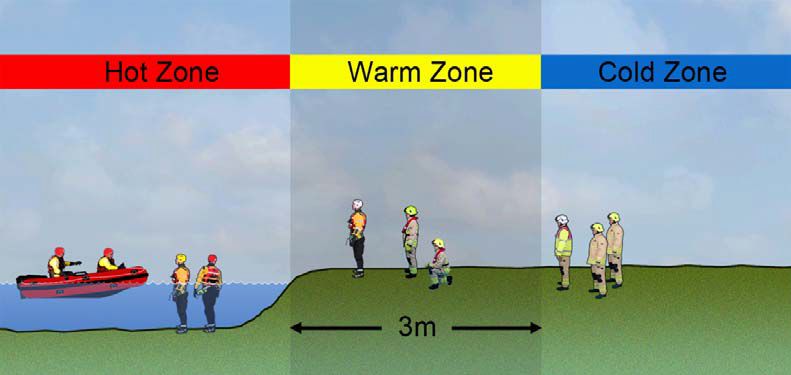
This content is only valid at the time of download - 29-06-2022 00:51 14 of 17movement of personnel depending on levels of training and available equipment. Where possible, areas should be indicated using physical barriers and access should be controlled but due to the large geographical area covered by some flooding and water incidents this may not be feasible. Where cordons or hazard zones are required it may be necessary to control access using comprehensive briefings and physical landmarks. Hazard zones are separated into hot, warm and cold zones. It may not always be appropriate to establish any zones, or access to the hot zone may be prevented depending on the risk assessment. Known bodies of water, with limited risk may not require any hazard zones to be established. The hot zone is usually defined as the area of water or unstable surface. This area may be expanded based on the risk assessment of the incident commander. The hot zone is the area of greatest risk where rescues will be carried out and should only be entered by rescuers with the appropriate training and personal protective equipment (PPE). The warm zone is the working area adjacent to the hazard, usually within three metres but this distance may be extended or reduced following a risk assessment. There may be a significant risk of uncontrolled entry into the water in this area. A warm zone may not be required when accidental entry into water can be prevented, or the hazard from entry is minimal such as still bodies of water with known depths. Personnel working in the area should be suitably trained, equipped and briefed to carry out specific tasks. The cold zone is the safe area located outside the hazard zones. Equipment dumps, holding areas, casualty reception centres and marshalling areas should all be located in this area. The cold zone is usually established 3 metres from the water’s edge, but this distance will depend on the ground conditions, slope and presence of barriers around the edge of the water and may be extended or reduced depending on the hazard and risk of uncontrolled entry. It is important that control zones are established, effectively implemented and communicated to all emergency responders as early as possible to maintain safe working areas and to assist in defining role responsibilities and objectives. This content is only valid at the time of download - 29-06-2022 00:51 15 of 17
Hazard zones for water related incidents

The geographic scale of operations during responses to wide area flooding can make management
of personnel difficult. To establish greater levels of command and control incident commanders
should consider logging the number of personnel committed to the risk area. This should include
the times of entry of personnel, assigned tasks and equipment. If necessary, consider placing
appropriate limits on durations committed to the risk area. The duration of commitment will
depend on the required tasks and environmental conditions. Regular radio contact should be
maintained and where possible a dedicated officer appointed to manage the safety of personnel.

Strategic actions

Fire and rescue services should:

      Provide appropriate means of implementing control zones and cordons at incidents involving
      water

      Provide all operational firefighters with water awareness training

Tactical actions

Incident commanders should:

      Consider establishing control zones at incidents involving water and communicate to all

This content is only valid at the time of download - 29-06-2022 00:51                         16 of 17
responders
Consider using cordon control gateways at incidents involving flooding
Ensure that personnel operate on the safe side of existing guarding near water or unstable
surfaces
Consider establishing an exclusion zone around any body of water or unstable surface where
no guarding exists
Manage hazards in the working environment that could lead to slips, trips and falls into
bodies of water or unstable surfaces
This content is only valid at the time of download - 29-06-2022 00:51 17 of 17You can also read