High-Resolution Annual Forest Carbon Monitoring Utilizing Remote Sensing - MCCC Mitigation Working Group March 16, 2021
←
→
Page content transcription
If your browser does not render page correctly, please read the page content below
High-Resolution Annual Forest Carbon
      Monitoring Utilizing Remote Sensing

Dr. George Hurtt, Dr. Carlos E. Silva, Rachel Lamb, Lei Ma and Quan Shen

                   MCCC Mitigation Working Group
                         March 16, 2021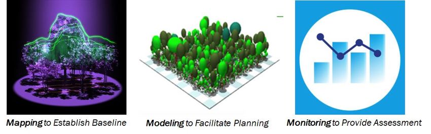
Overarching Project Goal:
  To provide an annual geospatial estimate of
forest carbon flux that can be used to evaluate
progress under the state’s climate action goals.
Use of consistent science products across spectrum of applications
Basic Workflow
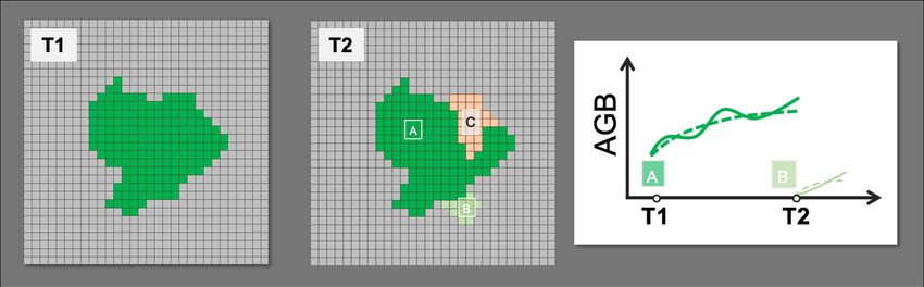
Annual Net Carbon Flux = Carbon Gains - Carbon Losses + Carbon Regrowth
Gains = ongoing growth over forested fraction of gridcell
Losses = amount of carbon in deforested area
Regrowth = amount of carbon reaccumulated on gridcells (new/expanded tree cover)
Versioning

                                                        Forest Area
                                                                         AGB Growth Drivers in ED
Version              Goal                  Period      Changes (RS)
                                                       Gain     Loss   Meteorology     CO2       Disturbance
          Efficacy of capturing remotely
  V1                                       2011-2019   NLCD     GFW    climatology   constant     constant
          sensed changes in forest area
             Efficacy of using transient   1980-2018    --       --     transient    transient    constant
  V2      drivers (meteorology, CO2 and
               disturbance) in model       1980-2018    --       --     transient    transient    transient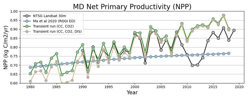
Annual Datasets
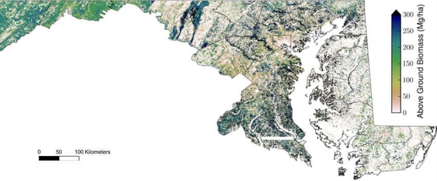
AGB GAIN AGB LOSS
AGB trajectories from ED model (2011 – 2311, 90 m resolution) Observed forest loss by year (2000 – 2019, 30 m resolution)
(Hurtt et al. 2019, Ma et al. 2020 in review) (Hansen et al. 2013) version 1.7 2000-2019
Decadal Dataset - GFW                                                        AGB REGROWTH (New Tree Cover)
                                                                       Detected gains per ~decade (30 m resolution, Hansen et al. 2013)

•   Binary classification over time period
•   No attribution by year
•   No attribution by cause (under development)
•   Sensitive to “forest” algorithm
•   2000-2012 data published now
•   Will incorporate when available

GWF definition : global forest cover (gain)
Defined as the inverse of loss, or a non-forest to forest change entirely within the study period. Encoded as either 1 (gain) or 0 (no gain)
Triennial Dataset - NLCD

• Attribution over 3-5 yr period    AGB REGROWTH
• Sensitive to “forest” detection   (New Tree Cover)
• 2011, 2013, 2016 cover            Detected gains per ~decade
  transitions                       (30 m resolution, NLCD 2011, 2013, 2016)

• Can incorporate 2019 data once
  released
Exploration of ED Drivers- Air Temperature & Precipitation

                                                             9
Exploration of ED Drivers- CO2 & Disturbance
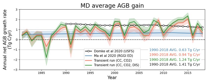
10NPP of transient runs
11AGB growth rate of transient runs
12Key Takeaways
1. Created monitoring prototype that is consistent with our existing suite of
mapping and modeling products, based on high-resolution remote sensing and
prognostic ecosystem modeling in concert with USFS data.
2. We found that we can get consistent monitoring results with the USFS, but with
added wall-wall coverage, increased temporal resolution, and added process
detail.
3. We seek to operationalize these products within Maryland and Delaware, expand
to other states and via USCA.
4. For MD, we are planning on v3, updated for use in MD 2020 inventory, summer
2021.
5. Through NASA CMS we have recently been selected to continue this work, and
expand the coverage nationally/globally (harnessing GEDI, ICESat-2, Landsat).References Hurtt, G. C., M. Zhao, R. Sahajpal, A. Armstrong, R. Birdsey, E. Campbell, K. Dolan, R. Dubayah, J. P. Fisk, S. Flanagan, C. Huang, W. Huang, K. Johnson, R. Lamb, L. Ma, R. Marks, D. O’Leary III, J. O’Neil-Dunne, A. Swatantran, H. Tang. (2019) Beyond MRV: High-resolution forest carbon modelling for climate mitigation planning over MD, USA. Environmental Research Letters. https://doi.org/10.1088/1748-9326/ab0bbe Hurtt, G. C., Q. Shen, C. E. Silva, L. Ma, R. L. Lamb. (2020) High-resolution monitoring of forest carbon sequestration to meet climate goals AGU Fall Meeting. Poster. Earth and Space Science Open Archive. https://doi.org/10.1002/essoar.10505479.1 Lamb, R., G. Hurtt, T. J. Boudreau, E. Campbell, E. C. Sepúlveda, H.-H. Chu; J. de Mooy, R. Dubayah, D. Gonsalves, M. Guy, N. Hultman, S. Lehman, B. Leon, A. Lister, C. Lynch, L. Ma, C. Martin, N. Robbins, A. Rudee, C. Silva, C. Skoglund, H. Tang. (2021-in press) Context and Future Directions for Integrating Forest Carbon into Sub-National Climate Mitigation Planning in the RGGI Region of the U.S. Environmental Research Letters. https://doi.org/10.1088/1748-9326/abe6c2 Tang, H., L. Ma, A. Lister, J. O’Neill Dunne, J. Lu, R. Lamb, R. Dubayah, G. Hurtt. (2021) High-Resolution Forest Carbon Mapping for Climate Mitigation Baselines Over the RGGI Region, USA. Enviromental Research Letters. https://doi.org/10.1088/1748-9326/abd2ef Ma, L., G. Hurtt, H. Tang, R. Lamb, E. Campbell, R. Dubayah, M. Guy, W. Huang, A. Lister, J. Lu, J. O’Neill Dunne, A. Rudee, Q. Shen, C. Silva. (2021-in press) High-resolution forest carbon modeling for climate mitigation planning over the RGGI region, USA. Environmental Research Letters. https://doi.org/10.1088/1748-9326/abe4f4
You can also read