IN POSEIDON'S REALM XXVI - Conference Folder 18.04.2021
←
→
Page content transcription
If your browser does not render page correctly, please read the page content below
DEGUWA Annual Meeting on Underwater Archaeology
IN POSEIDON’S REALM XXVI
Safety and Waterways
from May 8, 2021 through May 9, 2021
Online Conference in Cooperation with the TRANSMARE Institut of
the University of Trier
Under the Patronage of the President Prof. Dr. Michael Jäckel
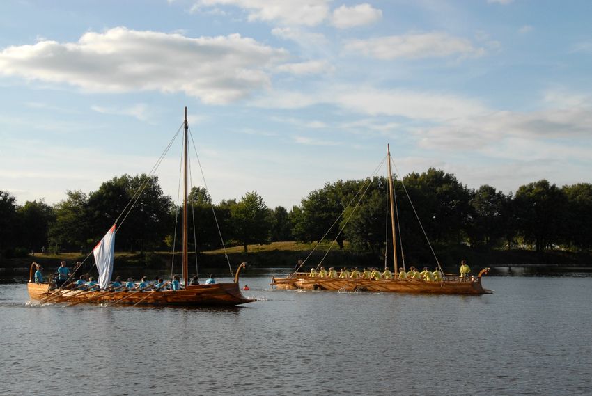
VICTORIA and LUSORIA RHENANA at joint patrol on the “Haltener See”
Photo: transmare institut
Stand: 19.04.2021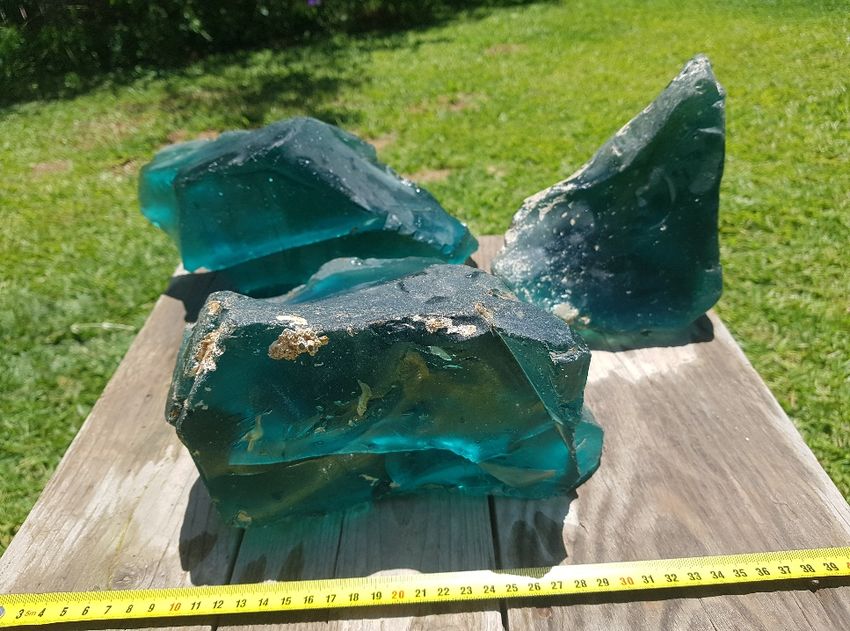
Organizing Committee:
Julian Heinz,, Ralph Kunz, Katharina Meyer-Regenhardt,
                                     Meyer Regenhardt, Georg Osterfeld, Thomas Reiser,
Christoph Schäfer, Peter Winterstein

Scientific Committee:
Ronald Bockius, Christoph Eger, Winfried Held, Marcus Nenninger, Christoph Schäfer, Peter
Winterstein

Executive Committee:
Julian Heinz,, Ralph Kunz, Katharina Meyer-Regenhardt,
                                     Meyer             Patrick Reinard, Christian Rollinger,
Christoph Schäfer, Birgit Sommer, Piotr Wozniczka,

                                                                                  Page 2 | 25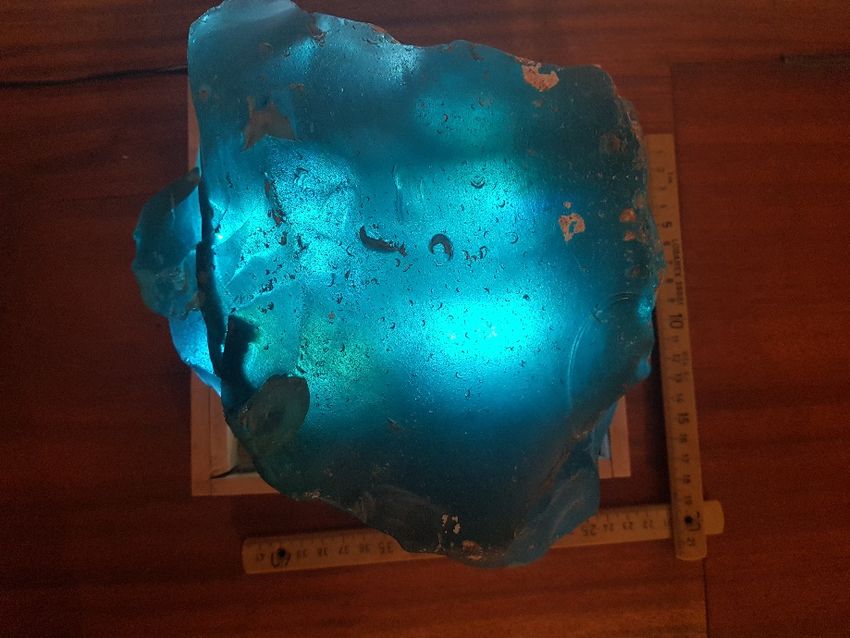
Program
Saturday, May 8, 2021
Lectures I
Instructions
Chair          Schäfer, Christoph
Time:          09.15-09.30 a.m.
Opening and Greetings
Winfried Held, President of the DEGUWA
Michael Jäckel, President of the University Trier
Time:          09.30-10.30 a.m.
Spanos, Stefanos
Schiffsdarstellungen auf Mykenischer Keramik. Die seltsame Darstellung eines
Schiffswracks von Koukounaries auf Paros
Coffee break
Time:          10.30-11.00 a.m.
Lectures I (cont.)
Chair:         Reiser, Thomas
Time:          11.00-12.30 p.m.
Reich, Alexander
Terra et aqua. - Untersuchung der Hafenbecken Milets unter nautischen Gesichtspunkten
Auriemma, Rita et al.
The underwater archaeology tells of Salento: Recent research in the Adriatic and Ionian
seas
Auriemma, Rita et al.
Shipwrecks stories in a “trap bay”: Research and valorization in Torre S. Sabina (Brindisi,
Italy)
Discussion
Time:          12.30-1.00 p.m.
Lunch break
Time:          1.00-2.30 p.m.
Lectures I (cont).
Chair:         Schmidhuber, Gabriele
Time:          2.30-3.30 p.m.
Wintjes, Jorit
Quartered safe out there? Towards a typology of Roman naval bases
Warnecke, Heinz
Safety first: the Mahdia wreck as a result of improper loading
                                                                                  Page 3 | 25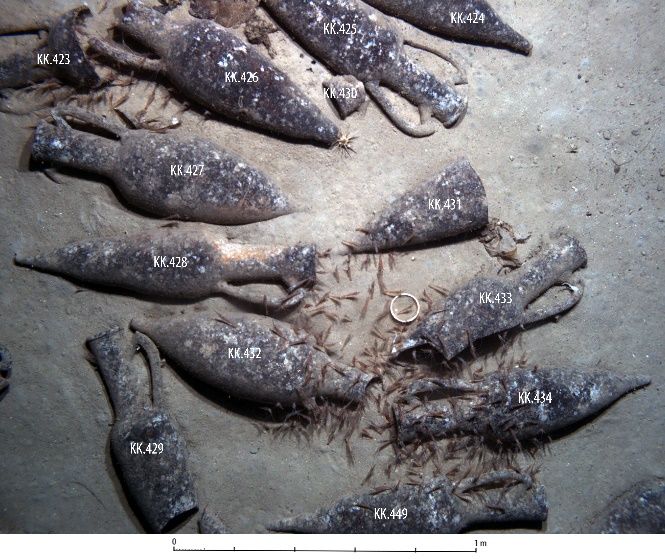
Coffee break
Time:          3.30-4.00 p.m
Lectures I (cont.)
Chair:         Heinz, Julian
Time:          4.00-5.00 p.m.
Reinard, Patrick
“Jeden Tag warten wir auf unsere Entlassungsurkunde”. Ägyptische Seefahrer und die
stadtrömische Verwaltung
Selke, Valeria and Franke, Regina
Neue Ergebnisse zu den Grabungen am Hafen der CUT
Discussion
Time:          5.00 p.m.
(Public) Evening Lecture
Schäfer, Christoph
Die römischen Militärschiffe von Oberstimm und Mainz und der Nasse Limes an Rhein
und Donau – Rekonstruktion, Tests, Ergebnisse
Time:          7.00 p.m.
WONDER & WINE – Evening Event
Time:          8.00 p.m.
Sunday, May 9, 2021
Lectures II
Chair:         Held, Sebastian
Time:          9.00-10.30 a.m.
Reinfeld, Michaela
“Don’t marry a skipper, you have no husband in summer, no money in winter”
Novichenkova, Maria V.
About the Roman Military Equipment of Augustus’ reign from the sanctuary Gurzufskoe
Sedlo as the archaeological evidence of the Roman military actions in the Northern Black
Sea region
Olkhovskiy, Sergey et al.
Phanagorian port construction according to archaeological and geological data
Coffee break
Time:          10.30-11.00 a.m.
Lectures II (cont.)
Chair:         Osterfeld, Georg
Time:          11.00-12.00 a.m.

                                                                                Page 4 | 25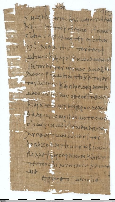
Fiederling, Max
Hin und wieder zurück. Das Wrack Portiței A: Interdisziplinäre Erforschung eines
römischen Handelsschiffes vor der Schwarzmeerküste Rumäniens
Discussion
Time:           12.00-12.30 p.m.
Lunch break
Time:           12.30-2.00 p.m.
Lectures II (cont.)
Chair:          Wozniczka, Piotr
Time:           2.00-3.30 p.m.
Grossmann, Eva
Glass from Apollonia/Israel
DellaPorta, Katerina P.
«Μηδείς φοβείσθω το πέλαγος» Ιωάννης Χρυσόστοµος (PG 50)
Σωτήρες γαρ εισίν οι θεοί, Αρτεµίδωρος, Ονειροκριτικά
Opait, Andrei; Davis, Dan and Brennan, Michael L.
A Case Study of Rhodian Wine Export: The Knidos K and J Shipwrecks
Coffee break
Time:           3.30-4.00 p.m.
Lectures II (cont.)
Chair:          Thurn, Maurice
Time:           4.00-5.30 p.m.
Byford-Bates, Alistair
The Assessment of the Environmental Risk from Casualties of War
Cundy, Ian and Hristov, Hristomir
NAS – Welsh Wreck Web – Research Project (2020)
Heine, Eike-Christian
Research in an extreme environment: Historical perspectives on underwater archaeology
Discussion
Time:           5.30 p.m.
Farewell Words
Chair:          Schäfer, Christoph

Subject to alteration.

                                                                               Page 5 | 25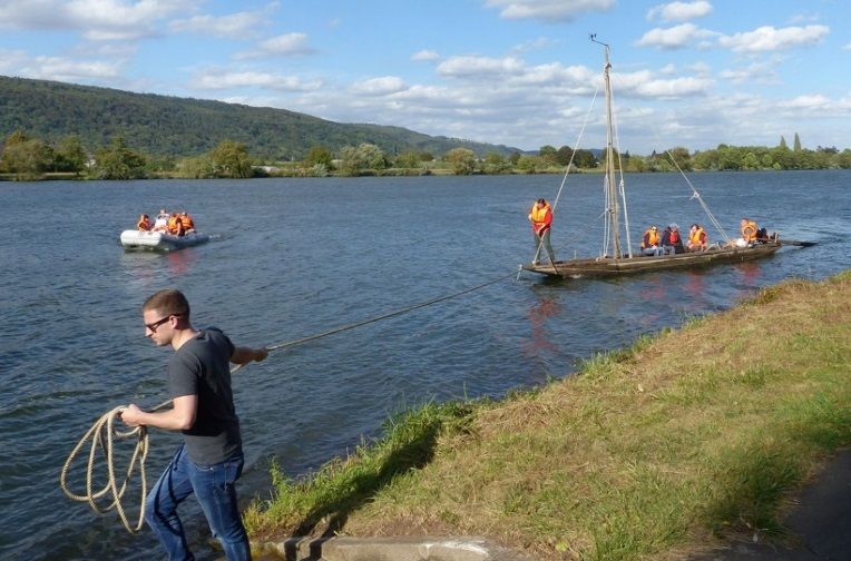
Abstracts

Auriemma, Rita - Buccolieri, Mino - Coluccia, Luigi - D’Ambrosio, Paolo -
Picciolo, Andrea - Rugge, Michela
                       The underwater archaeology tells of Salento:
                     Recent research in the Adriatic and Ionian seas

During September through October 2020,           Also in the “Le Cesine” Natural Reserve
underwater surveys were carried out by the       (Adriatic) the survey led to the identification
University of Salento in the crystalline         of new archaeological evidence. Of great
waters of southern Puglia.                       interest is the discovery of a big pier
                                                 perpendicular to the coast that lies a few
In the Porto Cesareo MPA of (Ionian sea),
                                                 meters deep. Investigated for a hundred
new evidence has been added to the
numerous ones already known (among which         meters, it has two parallel curtains of large
the submerged area of a Bronze Age               squared blocks, 8 meters thick. The structure,
settlement, the navis lapidaria wreck of the     which may have belonged to a port complex
                                                 of the Augustan age, could prove crucial to
Roman Imperial age, other wrecks of
                                                 the understanding of other buildings, closely
mediaeval and modern epoch, etc.): some
                                                 located.
spectacular formations (“blocks”) scattered
in a vaste area of the sea bottom, between 3.5   Some of this evidence seem to be significant
and 5.5 m deep, and composed uniquely by         markers of sea level changes and the
cemented sherds of Tripolitanian amphorae        seascapes evolution; furthermore, they have a
(2nd cent. AD), have been identified as          big potential for sustainable projects of in
remains of a supertanker sailing from the        situ preservation and valorization.
North African province to the Eastern
Mediterranean, along a direct route.

Auriemma, Rita; Coluccia, Luigi; Rugge, Michela, University of Salento – R. Auriemma first
author
Buccolieri, Mino, Coordinamento Ambientalisti pro Porto Cesareo ONLUS
D’Ambrosio, Paolo; Picciolo, Andrea , Porto Cesareo MPA

UnderwaterMuse
www.italy-croatia.eu/web/underwatermuse
www.facebook.com/Project-UnderwaterMuse-106106884192806/
Archeologia Subacquea – Università del Salento
www.unisalento.it/scheda-utente/-/people/rita.auriemma/didattica/1182442019/scheda
https://www.facebook.com/ArcheoSubUniSalento/

                                                                                      Page 6 | 25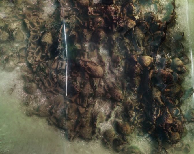
Auriemma, Rita - Antonazzo, Antonella - Calantropio, Alessio -
Chiabrando, Filiberto - Coluccia, Luigi - Leone, Danilo - Maschio, Paolo
Felice - Turchiano, Maria - Spanò, Antonia – Volpe, Giuliano
                            Shipwrecks stories in a “trap bay”:
              Research and valorization in Torre S. Sabina (Brindisi, Italy)

The 2020 underwater archaeological research       Thanks to the collaboration with the
in the inlet of Torre Santa Sabina - Baia dei     Polytechnic of Turin, the entire stretch of
Camerini (Municipality of Carovigno,              coast was mapped with drone flights, in order
Brindisi, Italy) represented the first phase of   to reconstruct the coastal landscape in the
the pilot intervention of the Interreg Italia-    various phases, starting from the Bronze
Croatia UnderwaterMuse project, which aims        Age.
to enhance and make accessible the huge
                                                  Targeted interventions were carried out on
underwater heritage of the areas involved
                                                  the Roman wreck of the imperial age,
through the creation of submerged
                                                  beached and abandoned at the ancient shore
archaeological parks and the narrative and
                                                  and now submerged due to the relative rise in
communicative use of the virtual reality. The
                                                  sea level, and on the remains of on-board
Puglia Region - Department of Tourism,
                                                  equipment of a ship of the Serenissima, the
Economics of Culture and Valorization of the
                                                  Galea Magna (1598).
Territory, partner of the UnderwaterMuse
project, launching these researches aimed at      Another important focus was represented by
valorisation, has involved the three regional     the stratigraphy of cargos resulting from the
Universities thanks to an agreement.              various shipwreck episodes, accumulated at
                                                  the foot of the western cliff.
The fruitful synergy between the various
actors involved and the support of the            Keywords: underwater cultural heritage, in
territory and the community have allowed the      situ protection and valorization, underwater
achievement of the objectives of this             archaeological    park,    VR,     seascapes
campaign, preliminary to the broader and          archaeology, wrecks, Roman ship, galley,
more articulated intervention foreseen for the    cargo.
next year.

Auriemma, Rita; Coluccia, Luigi, University of Salento – first author
Antonazzo, Antonella, TPP – Regione Puglia
Calantropio, Alessio; Chiabrando, Filiberto; Maschio, Paolo; Spanò, Antonia, Polytechnic
University of Turin
Leone, Danilo; Turchiano, Maria, University of Foggia
Volpe, Giuliano, University of Bari

UnderwaterMuse
www.italy-croatia.eu/web/underwatermuse; www.facebook.com/Project-UnderwaterMuse-
106106884192806/
Archeologia Subacquea – Università del Salento
www.unisalento.it/scheda-utente/-/people/rita.auriemma/didattica/1182442019/scheda
https://www.facebook.com/ArcheoSubUniSalento/

                                                                                      Page 7 | 25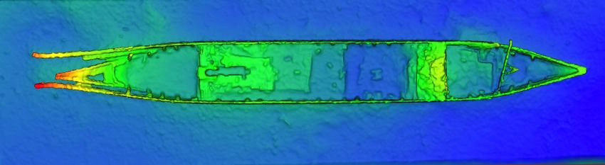
Auriemma, Rita - Antonazzo, Antonella - Beltrame, Carlo - Costa, Elisa -
Kamenjarin, Ivanka - Leone, Danilo - Pizzinato, Claudia - Šuta, Ivan -
Turchiano, Maria - Volpe, Giuliano
               The “invisible” heritage to the challenge of the valorization:
                                The UnderwaterMuse Project

The Adriatic sea is dotted with wrecks and its     archaeological park (or eco-museum)
                                                                                    eco
coasts are scattered by a lot of underwater        through innovative and/or experimental
sites. The routes, the types of hulls and their    methodologies and techniques in order to try
cargos, the different types
                          es of coastal sites in   to reduce the loss of important cultural
some cases have been well studied, in others       heritages as well as to guarantee an economic
only the coordinates are known. The UM             spin-off
                                                        off deriving directly from the creation of
project focuses on some of them, in order not      a sector linked to the tourist-cultural
                                                                                   tourist
only to increase knowledge, but above all to       promotion of the context of reference.
make them visitable by as many people and
                                                   An immersive virtual reality (VR) approach
in different wayss as possible, always paying
                                                   renders underwater sites accessible to a wider
the utmost attention to their integrity.           public, including people with different kinds
The project aims at applying on sample areas       of disabilities. Training diving guides will
(maritime landscapes of Torre Santa Sabina,        improve the immersive experience
                                                                                 experienc     of
Grado,        Resnik/Siculi,     Caorle)      a    underwater sites. Based on the experience
methodological and technological protocol          gained, an innovative promotional GIS tool,
based       on     research/knowl
                   research/knowledge       and    the ‘UnderwaterMuse MAP’ for promoting
development/communication of underwater            underwater sites with accessibility standards,
archeological sites that are complex and           will be developed. The ‘UnderwaterMuse
multi-stratified,
       stratified, characterized by strong         MAP’ will be promoted at transnational,
diversity. The project’s objective is therefore    national and local level, in the Adriatic and
to transform the site into an underwater           beyond.

Auriemma, Rita, University of Salento – first author
Antonazzo, Antonella, TPP – Regione Puglia
Beltrame, Carlo; Costa, Elisa, Ca’ Foscari University of Venice
Kamenjarin, Ivanka; Šuta, Ivan Civic Museum of Kaštela
Leone, Danilo; Turchiano, Maria, University of Foggia
Pizzinato, Claudia, Informest – FVG
Volpe, Giuliano, University of Bari

                                                                                        Page 8 | 25
Byford-Bates, Alistair
           The Assessment of the Environmental Risk from Casualties of War

In 2015 Wessex Archaeology were                  We demonstrate how using a combination of
commissioned by the UK Ministry of               publicly available primary and secondary
Defence’s Salvage and Marine Operations to       sources related to the construction, history
carry out a study examining the                  and loss of the vessel combined with recent
environmental risk from vessels under their      published research into environmental
purvey, predominantly lost during the            pollution risks, hazard analysis and
conflicts of the 20th Century, or sunk in the    assessment have allowed vessels at risk to be
immediate aftermath, as part of the disposal     ranked and remediation put in place. This
of hazardous munitions at the end of the         allows for more targeted pre-emptive action
Second World War. These vessels include          to be planned, replacing the current more
warships lost between 1870 and 1982, and         reactive approach to responding to
merchantmen and tankers from both World          environmental emergencies brought about by
Wars, as well as later conflicts, that were      the effects of decades underwater. The caveat
under Admiralty control. Geographically          to this is ongoing issue of ordnance and its
these vessels are spread across the world, and   mitigation. The use of standardized
in some cases potentially under multiple         approaches to environmental risk assessment
national jurisdictions.                          of potentially polluting wrecks, allows for an
                                                 international       multiagency/governmental
                                                 approach to be developed in the future for
                                                 managing existing, and future military and
                                                 civilian ship casualties.

Alistair Byford-Bates
Senior Marine Archaeologist
Wessax Archaeology

                                                                                      Page 9 | 25
Cundy, Ian - Hristov, Hristomir
                   NAS – Welsh Wreck Web – Research Project (2020)

In 2002, the Welsh Government’s Historic         The project is due to run until the end of
Environment Service (Cadw), asked the            2020, and at the time of writing, 61-    61
Malvern Archaeological Diving Unit               researchers, based in 13-countries,
                                                                            13            are
(MADU) to examine a shipwreck in Cardigan        engaged in researching 185-vessels,
                                                                          185         and 45-
Bay, West Wales, that is designated under the    reports have already been submitted. For the
United Kingdom’s Protection of Wrecks Act        latest information, see:
(1973). The exercise was to determine            http://www.madu.org.uk/Page%204.42%20-
                                                 http://www.madu.org.uk/Page%204.42%20
whether the remains on the seabed were from      %20www%20Research%20Project%20
                                                 %20www%20Research%20Project%20-
a vessel known as the Diamond that wrecked
                                                 %202020.dwt
in 1825.
                                                 One of the project’s researchers Dr. Hristov
During MADU’s investigations, a database
                                                 took on research into the loss of two vessels
was compiled of 453-vessels
                      vessels known to have      from the database which would serve as
been involved in maritime incidents in the
                                                 examples underlining the project’s variety as
vicinity of the site.                            to different types of ships investigated,
In 2020, with Covid-19  19 restrictions being    chronological range and nature of incidents –
imposed on many people around the world, a       the sailship De Jung Jacob that was driven
project was developed for anyone interested      ashore in 1800, and the tanker Lucellum that
in carrying out on-line
                   line research and reporting   caught fire in 1941. He will recount his
on some of the many vessels on the database,     experience of taking part in the project, and
see:                                             the results derived from his locked down, on-
                                                                                            on
                                                 line, investigations during
                                                                           ing the Covid-19
                                                                                      Covid
https://www.nauticalarchaeologysociety.org/
                                                 pandemic.
welsh-wreck-web-research-project
                          project

                                                                   Map of North Cardigan
                                                                   Bay, West Wales, taken
                                                                   from "Shipwrecks of
                                                                   North Wales" by Ivor
                                                                   Wynne Jones, (This map
                                                                   shows around 33% of the
                                                                   wrecks on the “www
                                                                   Research      Project’s”
                                                                   database)

Ian Cundy B.Sc. M.A. (principle at the Malvern Archaeological Diving Unit (MADU), &
Welsh regional representative for the Nautical Archaeology Society (NAS), United Kingdom)
Dr. Hristomir Hristov (senior expert and researcher at the Naval Museum Varna Branch of
the National Museum of Military History, Sofia, Bulgaria)

                                                                                   Page 10 | 25
DellaPorta, Katerina P.
«Μηδείς φοβείσθω το πέλαγος» Ιωάννης Χρυσόστοµος (PG 50)
Σωτήρες γαρ εισίν οι θεοί, Αρτεµίδωρος, Ονειροκριτικά.
According to Greek mytho- It seems that the cult of St.
logy, many were the sea gods Phocas as the patron saint of
and demons that sailors sailors was displaced by the
turned to either to seek their cult of St. Nicholas, but was
protection, or to appease saved, like that of St. Isidore
them with sacrifices and in the coastal and island
prayers and to prevent toponyms of the Greek seas,
impending calamities. declaring capes and generally
dangerous areas for
For today's sailors, Saint
Nicholas is the most popular navigation.
saint and his cult, as the These places are located and
protector of sailors, is preserved in ruins in chapels
widespread throughout the and small churches dedicated
Christian world from the to the worship of the two
Middle Ages until today. Saints Phocas and Isidore, in
However, until the 7th century proportion to the ancient
and for the entire early Greek sanctuaries of
Byzantine period, the patron Poseidon scattered through-
out Greece. The present study
saint of the Byzantine sailors
was Saint Phocas, with his on the worship of these saints
center of worship was in for the protection of seafarers
is based on information from
Sinope in the Black Sea,
while much less known as the the lives of the saints, on the
patron saint of sailors was indications of medieval and
Saint Isidore the sailor from modern maps, on the
insularia as well as on the
Chios island.
iconography.
Archaeologist
Ministry for Culture
Director of the Byzantine and
Christian Museum
Page 11 | 25Fiederling, Max
Hin und wieder zurück. Das Wrack Portiței A
Interdisziplinäre Erforschung eines römischen Handelsschiffes vor der
Schwarzmeerküste Rumäniens
Im Zentrum des Dissertationsvorhabens von Dadurch wird es möglich sein, neue
Max Fiederling steht die archäologische Erkenntnisse zu regionalspezifischen
Auswertung des kaiserzeitlichen Schiffsbautechniken und römischen
Schiffswracks Portiței A, welches im März Handelsrouten im Schwarzen Meer zu
2016 im Rahmen eines liefern. Aufgrund der Erhaltungsbedin-
Kooperationsprojektes der Bayerischen gungen stehen auch bisher in der Forschung
Gesellschaft für Unterwasserarchäologie, der wenig beachtete Objektgruppen wie das
LMU München und dem ICEM Tulcea Ballastmaterial oder kleinste botanische
entdeckt und anschließend bis Ende 2018 Reste im Fokus der Untersuchungen.
erforscht werden konnte.
Bei dem Handelsschiff mittlerer Größe
Das vorrangige Ziel ist die detaillierte handelt es sich außerdem um den ersten in
Auseinandersetzung mit der Bautechnik und situ erhaltenen Leerguttransporter seiner Zeit,
konstruktiven Merkmalen, sowie der Ladung was weitere Fragen zum Handelsnetz und
des Schiffes. Ebenso stehen die Herkunft, das den Spezifika des betreffenden Wirtschafts-
Ziel und die Besatzung sowie die genauen raumes in römischer Zeit auf den Plan ruft.
Umstände seiner Havarie im Fokus.
Das Wrack ist aufgrund seiner exzeptionellen
Erhaltung von herausragender (schiffs-)
archäologischer Bedeutung. Im Gegensatz zu
den bisherigen, durchaus spektakulären
antiken Wrackfunden im Schwarzen Meer,
die im Rahmen der Forschungsmissionen von
Robert Ballard und dem MAP Projekt in den
letzten Jahren gemacht wurden, liegt das
Wrack Portiței A im Flachwasser. Es ist
daher im Schwarzmeerraum das erste seiner
Art, das umfassend und mit modernen
Methoden prospektiert und ergraben werden
konnte.
Page 12 | 25Grossmann, Eva
Glass from Apollonia/Israel
Glass production and
glass artifacts can be
traced on the eastern
Mediterranean coast as
early as the first century
AD, but excavations
show that one of the most
important centres during
the Byzantine period was
at Apollonia. At our
maritime survey at
Apollonia we discovered
chunks of glass ingots at
the store-houses and next
to the break-waters,
which most probably fall
when loading to ships.
Through this period were at
Apollonia numerous glass
furnaces, which when out of
use were abounded and new
constructed.
The glass from Apollonia
was clear blue, but there are
places where greenish glass,
due to change of
temperature, can be traced
Page 13 | 25Heine, Eike-Christian
Research in an extreme environment:
Historical perspectives on underwater archaeology
I am neither an archaeologist nor a diver. I In a first step I will tell the story how and
am, however, a historian who ended up being why Frost, Peter Throckmorton (1928-1990)
interested in the history of both activities. and Frédéric Dumas (1913-1991) initiated
While researching for my second book I fieldwork in 1958. They started one of the
stumbled upon the papers of Honor Frost first projects to carry out a systematic
(1917-2010), which are collected in campaign under the water surface. I will
Southampton. present the archaeological questions asked as
For me, the DEGUWA-meeting would be an well as the concrete problems and working
excellent forum in two respects: methods employed at the coast of Asia
Minor. After this first step tells a story from a
First, it would offer the possibility to discuss narrow perspective of the history of science,
findings with actual underwater the second part of my presentation widens its
archaeologists. angle. I will argue that underwater
Second, I hope to be pointed towards archaeology was only one field, in which
historical material that would allow an technological innovation opened up new
understanding of the formation of underwater research possibilities. Under the specific
archaeology as a discipline. conditions of the Cold War, global extreme
environments increasing became new spaces
In my presentation I would like to do two for research in various disciplines.
things.
Dr. Eike-Christian Heine, TU Braunschweig, Institut für Geschichtswissenschaft
eike-christian.heine@tu-bs.de
Page 14 | 25Novichenkova, Maria V.
About the Roman Military Equipment of Augustus’ reign from the sanctuary
Gurzufskoe Sedlo as the archaeological evidence of the Roman military actions in the
Northern Black Sea region
About the Roman Military Equipment of group of the Roman military equipment is
Augustus reign from the sanctuary presented by Roman military equipment of
Gurzufskoe Sedlo as the archaeological Augustus rule. It contains the details of gladii
evidence of the Roman military actions in the of type Mainz (fig. 2), helmets, shields,
Northern Black Sea region. chain-mail Lorica Hamata, cingulum
The paper deals with questions of militare, early Aucissa fibulae, surgical
instruments, military camp tools, an Arezzo
archaeological sources of Roman military
naval actions with high probability which Terra Sigillata, metal ware. By this period
date the 53 of Roman Augustus coins, the
took place in the Northern Black Sea region
Bosporan coins of Asander, Dynamis,
during the Augustus reign, in particular, M.
Polemo I1. The bulk of pieces of Augustus
Vipsanius Agrippa Roman military naval
reign from Gurzufskoe Sedlo typologically
expedition in Bosporus (Oros. VI. 21. 28;
correspond with finds of personal military
Dio. Cass. LIV. 24; Jos. Ant. XVI, 2).
equipment of the of Roman naval camps of
The most massive archaeological source Marcus Vipsanius Agrippa, early Roman
which correlates with these events are the legionary camps and auxilia castells of Limes
materials of the Scytho-Tauri sanctuary Germanicus – Lower Germanic and Upper
Gurzufskoe Sedlo in Mountain Taurica (fig. Germanic-Rhaetian Limes of the right bank
1) where the war trophies of Roman armour of Rhine and the valley of the Lippe River
of the 2nd c. BC – the 3rd c. AD were during the time of Drusus (13–9 BC) and
revealed, and the major and the largest for Tiberius (8–7 BC, 4–5 AD) military
this period for the Northern Black Sea region campaigns.
Fig. 1. The view on sanctuary near the pass Fig. 2. A bronze silvered handguard of gladius type
Gurzufskoe Sedlo (1434 m) from the North-East. Mainz, 20s of 1st c. BC. Sanctuary near the pass
Gurzufskoe Sedlo.
M. V. Novichenkova Ph.D., Scientific Researcher, Institute of Archaeology ,National
academy of Sciences of Ukraine, Kiev, Email: novichenkovamaria@gmail.com
1
Stored in archaeological funds of Yalta Historical and Literary Museum.
Page 15 | 25Olkhovskiy, Sergey – Khotylev, Aleksey – Mayorov, Alexander
Phanagorian port construction according to archaeological and geological data
A stone mound of 190-200 meters in length As it turned out, the height of the mound is
and up to 60 meters wide, which is, most over 2.5 meters, and the total volume of
likely, remains of a pier or a jetty, was found
stone it’s composed of is between 65000 and
during a hydromagnetic survey in the water 75000 cubic meters. A stratigraphic research
area of Phanagoria, an Ancient Greek city showed that the mound was built in at least
located in the Taman Bay of the Black Sea. four stages, which differ in material and
Phanagoria did not possess a natural harbor,building technology. Based on ceramics
but still wanted to become a maritime trade found in the two pits, we suggest that the first
center, so the construction of a big port three stages of construction were carried out
seems to be reasonable. But was this port in V-III centuries B.C., while the fourth stage
built all at once or step by step, in different
is dated to VIII-IX centuries A.D. The
stages? When was it built and what from? bottom layer of the mound is composed of
How long did it function? local limestones, the next two stages are built
In order to answer these questions, we made with stone brought from outside of the north
two survey pits, one in the seaward part of coast of the Black Sea. It is not clear why
the mound and one — in the coastal. would anybody want to carry out the fourth
stage of construction in IX century A.D., as
by them the port of Phanagoria was half-sunk
and could not accept seafaring ships.
Page 16 | 25Opait, Andrei; Davis, Dan and Brennan, Michael L.
A Case Study of Rhodian Wine Export: The Knidos K and J Shipwrecks
In 2010-2011, two ancient shipwrecks were small groups on a few shipwrecks, and a few
discovered and documented by the E/V badly plundered sites appear to represent
Nautilus expedition near Knidos at the cargoes. In the eastern Mediterranean, the
western tip of the Datça peninsula in best example is the badly looted Akandia A
southwest Turkey. High-resolution imagery site off Rhodes city, which managed to
from both wreck sites permits a preliminary preserve 270 amphorae. Recent underwater
analysis of their cargoes. Knidos K (wreck research in the Adriatic as well as in the
mound: 15 x 8 m) was carrying three variants central and western Mediterranean have
of Rhodian amphorae (small, medium, and increased the numbers of sites and are
large capacities) dating to the 1st century sharpening the picture of its distribution
AD, as well as a Cretan amphora (type AC3) networks. Knidos J and K add important
and a jug. Knidos J (13 x 6 m) was carrying information regarding the local networks
medium and large variants of the same involved during the initial stages of
amphora type, in addition to a Knidian distribution. The modest size of these ships
amphora. Just 7 kilometers separate the would have allowed them to sail into and out
wrecks, both of which lie 5 km offshore. of the many bays, gulfs, harbors and ports
Kilns that manufactured these amphorae are that indent the coastlines of the Datça and
known in Rhodes, its Peraia, and in Caria; Bozburun peninsulas. We speculate that they
one of the most important production centers were destined for a large emporium, such as
seems to have been Kallipolis near the head Knidos or Rhodes, to offload their
of the Gulf of Gökova (ancient Kerameios consignment for transshipment elsewhere in
Sinus). The amphora type is associated with the Empire, but foundered in a heavily-
the famous sweet Rhodian dessert wine trafficked sea-lane known for heavy winds
passum, although evidence of other products and occasional bad weather.
such as figs, possibly also preserved in
passum, have also been found. This wine
seems to have been less famous than Chian
and Lesbian wines, but its widespread and
voluminous distribution in the
Mediterranean, western Europe, Britain and
even India during the first two centuries AD
demonstrate mass consumption and high
demand. In spite of numerous terrestrial
discoveries over the past four decades,
however, shipwrecks with early Roman
Rhodian amphora type are rather rare. The
type has been identified as singletons or in
Page 17 | 25Reich, Alexander
Terra et aqua.
Untersuchung der Hafenbecken Milets unter nautischen Gesichtspunkten
Die antike Stadt Milet (Türkei) besaß durch Die Bearbeitung der Fragestellung erfordert
ihre Lage am Ausgang des Mäanderdeltas an neben der Neubewertung von Bohrkernen die
der südionischen Küste eine strategisch Analyse der nautischen Bedingungen, die für
günstige Position. Strabon zufolge verfügte Milet erstmalig rekonstruiert werden sollen.
die Stadt über vier Häfen (Geographica Dazu werden auch die Winde und
14.1.6). In mehreren Kampagnen wurden die Strömungen in dem Gebiet betrachtet, da sie
Gebiete mit geophysikalischen Surveys und direkten Einfluss auf die Navigation und
Bohrkernproben durch H. Stümpel und somit die Zugänglichkeit gehabt haben
H. Brückner untersucht, wodurch die könnten. Aufgrund der Verlandung des
geomorphologischen Entwicklungen der Gebietes handelt es sich dabei um schwer
milesischen Halbinsel nachvollzogen werden nachzuvollziehende Faktoren, weshalb
können, die von der Archaik bis in die Lösungen und Untersuchungsansätze
Kaiserzeit besonders starke Veränderungen vorgeschlagen werden sollen. Zudem werden
aufweisen. verschiedene Schiffstypen untersucht, da sie
In meinem Vortrag beschäftige ich mich mit unweigerlich von all diesen Einflüssen
der Rekonstruktion der mittlerweile betroffen gewesen sein müssen. Um ein
versandeten Hafenbecken mit Fokus auf den vollständigeres Bild zu erhalten, sollen
Hellenismus und die frühe römische Phase, zusätzliche Orte für Bohrkernproben in
um mithilfe des nautischen Profils die Aussicht gestellt werden. Die
Leistungsfähigkeit der Häfen in Bezug auf geoarchäologischen Ansätze können,
Zugänglichkeit und Umschlagsvolumen zu zusammen mit den bisherigen klassisch
analysieren und baue dafür auf den archäologischen Methoden, ein besseres Bild
geoarchäologischen Arbeiten auf. davon vermitteln, wie und in welchem
Umfang die Becken angefahren werden und
welches Handelsvolumen die milesischen
Häfen bewältigen konnten.
Alexander Reich, B.A.
Institut für Archäologie und Kulturgeschichte des antiken Mittelmeerraumes
Universität Hamburg
Alexander.reich@studium.uni-hamburg.de
Page 18 | 25Reinard, Patrick
Jeden Tag warten wir auf unsere Entlassungsurkunde.
Ägyptische Seefahrer und die stadtrömische Getreideversorgung
Die Lebensmittelversorgung (cura annonae) Selten wird jedoch auf die papyrologische
der Stadt Rom ist ein bemerkenswertes Überlieferung geachtet, die eindringliche
Beispiel für die zum Teil staatlich gelenkte – Informationen über Schiffer und ihr
oder besser gesagt: motivierte – Mobilität „Agieren“ innerhalb der vom Staat
von Gütern, Personen und Schiffen auf dem vorgegebenen administrativen Strukturen
Mittelmeer. Das konstante Bedürfnis der liefert. Als ein Beispiel soll in dem Vortrag
Versorgung der Stadtbevölkerung war ein Papyrusbrief (BGU 1/27; 2./3. Jh.
politisch hochbrisant, da die Akzeptanz der n.Chr.) aus Ostia / Portus vorgestellt und
Kaiserherrschaft u.a. mit der Sicherung des analysiert werden. Absender des Briefes ist
Getreidebedarfs zusammenhing. Deshalb ein ägyptischer Getreideschiffer. Seine
wurden im 1. Jh. n.Chr. eine beachtliche Nachricht eröffnet einen unmittelbaren
Infrastruktur (horrea, Hafenerweiterung, Einblick in die Situation des Schiffers, bietet
Leuchttürme etc.), eine strikt hierarchische konkrete Zeitangaben und lässt sich in den
Administration (praefectus annonae etc.) aus epigraphischen, literarischen und
sowie juristische Anreize gegenüber den archäologischen Quellen bekannten Kontext
collegia der navicularii entwickelt, die eine der cura annonae sehr gut einordnen.
Sicherung und Kontrolle der Lebensmittel- Anhand dieser Quelle wird die zeitliche
versorgung garantieren sollten. In Ostia, Abfolge der verschiedenen Vorgänge
Portus und Rom kann dies anhand (Löschen der Seeladungen, Umladen auf
epigraphischer, literarischer und archäolo- Flussschiffe der codicarii, Transport nach
gischer Quellen untersucht werden. Rom etc.) ersichtlich.
Photo: Christoph Schäfer, Alte Geschichte, Universität Trier
Papyrus:
BerlPap. Berliner Papyrusdatenbank:
https://berlpap.smb.museum/01700/
Page 19 | 25Reinfeld, Michaela
“Don’t marry a skipper, you have no husband in summer, no money in winter”
In the 19th and 20th centuries, transport In addition to the scientific investigations,
shipping on the waterways in the Mark numerous illicit excavations took place,
Brandenburg was truly no picnic. The rising which make a clear identification of the ship
capital of Berlin and the province of owner largely impossible today.
Brandenburg needed huge amounts of
The lecture gives an overview of past and
building materials for the numerous brick
current research on the “Kaffenkähne” in the
and other buildings. But the skipper who
Werbellinsee. Due to the increasing decay
transported these building materials were
and the threat posed by the invasive nature of
simple people and shipping was a family
the quagga mussel, the documentation of the
business where everyone had to lend a hand.
sunken shipwrecks is becoming more and
For more than ten years, the association more urgent. Which successes but also
Kaffenkahn e.V. has been dealing with the problems arise will also be discussed in the
witnesses of the Wilhelminian time, the lecture.
sunken “Kaffenkähne” in the Werbellinsee.
Meanwhile, our association knows about 14
boats, from the splendidly built “Butzer”,
over the elongated “Spitzkahn”, to the
“kleiner Kahn” (“little boat”), an
indispensable companion of its big sister.
Four of these boats alone could only be
located or certainly identified in the last two
years. Various excavations have already been
carried out on individual wrecks, giving
insights into the life of the skippers and the
equipment of the historical barges. Fig. 2: Excavation scene at a “Kaffenkahn”
Nonetheless, the individual fates of the
skippers who owned the respective transport
boat are largely unknown.
Fig. 1: 3D model of a “Kaffenkahn” as depth map (photo: Kaffenkahn e.V., 3D modelling: B. Fritsch)
Michaela Reinfeld (Deutsches Archäologisches Institut/Römisch-Germanische Kommission)
Page 20 | 25Schäfer, Christoph
Die römischen Militärschiffe1 von Oberstimm und Mainz und der Nasse Limes an Rhein
und Donau – Rekonstruktion, Tests, Ergebnisse
In Oberstimm und Mainz wurden in den Dabei lässt sich die Veränderung in der
letzten Jahrzehnten die besten Schiffsbautechnik mit Messwerten
archäologischen Befunde römischer untermauern. Im Zuge der Erforschung
Militärschiffe bzw. -boote entdeckt. dieser Nachbauten wurde ein elektronisches
Fahrzeuge dieser Art bildeten das Rückgrat nautisches Messinstrumentarium etabliert,
der flussgestützten Verteidigung des das die präzise Analyse der Schiffe erlaubt.
Imperium Romanum. Diese wurde umso Daraus ergeben sich weitreichende
wichtiger als im 3. Jh. n.Chr. der Limes Folgerungen hinsichtlich der Maßnahmen zur
aufgegeben werden musste und die Ströme Sicherung der Wasserwege bzw. des „Nassen
Rhein und Donau zu Verteidigungsgrenzen Limes“, der Steuerungsmechanismen der
wurden. Die Befunde stellen eine Reichszentrale sowie der Kommunikations-
hervorragende Grundlage dar für wege und der Logistik. Nicht zuletzt lässt
Rekonstruktionen, anhand derer wir viele sich auch die Einstellung der Römer zu
Details über die antike Schiffsbautechnik und technologischem Fortschritt beleuchten.
das Leistungsvermögen dieser Fahrzeuge
wiedergewinnen können.
Lusoria Flächenaufbau Lusoria Spanten
1
Streng genommen handelt es sich um offene Mannschaftsboote, denen das Deck fehlt, das Schiffe aus-
macht. Da sich der Ausdruck Schiffe für die Wracks eingebürgert hat, wird er hier weiter verwandt.
Page 21 | 25Selke, Valeria; Franke, Regina
Neue Ergebnisse zu den Grabungen am Hafen der CUT.
Der Flusshafen der CUT und ihrer Am römischen Rheinufer wurden spätestens
Vorgängersiedlung lag vor der nordöstlichen ab den 40er Jahren des 1. Jahrhunderts eine
Stadtmauer der späteren Koloniestadt. Der Uferbefestigung, eine mehrfach umgebaute
Rhein beschrieb zur Römerzeit einen flachen hölzerne Kaianlage und ein Schiffshaus
Bogen direkt vor der kaiserzeitlichen errichtet. Der Hafen wurde mindestens bis
Ansiedlung. Durch das ständig zur Mitte des 3. Jahrhunderts, wahrscheinlich
durchfeuchtete Bodenmilieu und die fehlende aber bis in die Spätantike weiter genutzt.
moderne Überbauung zählen die
Hafeneinbauten und weitere zugehörige
Strukturen zu den am besten überlieferten
zivilen Flusshäfen der Nordwestprovinzen
des Imperium Romanum.
Page 22 | 25Stefanos, Spanos
Schiffsdarstellungen auf Mykenischer Keramik.
Die seltsame Darstellung eines Schiffswracks von Koukounaries auf Paros.
Der Fall der mykenischen Paläste markierte Das Schiff von Paros kann mit der
eine radikale Veränderung in der Darstellung eines Schiffes von Skyros und
geopolitischen Karte des prähistorischen einen zweiten Darstellung eines Schiffes von
Griechenland. Die Ausgrabungen zeigten, Tragana verglichen werden. Der Bug ist wie
dass unmittelbar nach der Zerstörung der bei diesen beiden Schiffen gebogen. Das
mykenischen Zentren auf dem griechischen Segel ist durch den Wind aufgeblasen.
Festland eine Gruppe mykenischer
Die Darstellung erinnert eher an eine
Flüchtlinge nach Paros floh, wo sie einen
Schiffswrack Szene wie die an der Nordwand
Hügel besetzten, den sie in eine mykenische
des großen Tempels von Medinet Habu.
Akropolis verwandelten. Es folgte eine Zeit
des Wohlstands, wie verschiedene Funde Die Funde aus Koukounaries auf Paros
zeigten, wie z. B. Elfenbein, Bergkristall, zeigen, dass nach dem Zusammenbruch der
Bronze, bemalte Keramik aus der späten Mykenische Paläste des Festlandes eine
helladischen IIIC mitten-Zeit. Periode des Wohlstands folgte, die auf der
Wiederbelebung der Künste und des Handels
Eine tiefe Schale (Skyphos) aus dieser Zeit
beruhte. Luxusfunde aus Paros belegen, dass
aus Koukounaries bietet eine seltene
Koukounaries bedeutende
Darstellung eines Schiffes. An der Innenseite
Überseeverbindungen mit den Kykladen
läuft eine Band um den Rand. Draußen ist
Inseln hatte, die sich an der Kreuzung des
ein Schiff kopfüber dargestellt Es ist eine
Seehandels mit Kleinasien, Ägypten, Syrien,
seltene Darstellung eines mykenischen
Zypern und Kreta befinden.
Schiffswracks.
Page 23 | 25Warnecke, Heinz
Safety first: the Mahdia wreck as a result of improper loading
Safety first: Das Mahdia-Wrack als Resultat unsachgemäßer Beladung
Safety at sea has often been compromised by Die Sicherheit auf See wurde oft durch
improper loading of cargo. The famous fehlerhaftes Laden der Fracht beeinträchtigt.
Mahdia ship which sank off the Tunisian So sank das mit ca. 300 t Architekturgliedern
coast while transporting approx. 300 tons of und Kunstgütern beladene Mahdia-Schiff vor
architectural elements and artworks suffered der tunesischen Küste infolge der vertikal
damage of incorrect vertical weight ungünstig gestauten Fracht. Der Vortrag
distribution of the cargo. The lecture rekonstruiert die Anordnung der Frachtstücke
reconstructs the arrangement of the freight anhand des Fundhorizontes sowie der Reste
items on the basis of the find horizon and the des Schiffskörpers.
remains of the hull.
Da der Gewichtsschwerpunkt des beladenen
Since the center of gravity of the loaded ship Schiffes zu hoch über dem Auftriebs-
was too high above the center of buoyancy schwerpunkt lag, war die Seetüchtigkeit
the seaworthiness was so much reduced that derart gemindert, dass der antike Frachter
the ancient freighter could by no means have keineswegs den über 700 sm langen Seeweg
covered the 700 nm long sea route from von Athen bis Tunesien zurückgelegt haben
Athens to Tunisia as is postulated in kann, wie in der Archäologie postuliert wird.
archeology. An important indication thereof Ein gewichtiges Indiz dafür sind die
are also the Lead seals which have the Bleiplomben der Waren, die die
stamps of the Roman province of Africa Prägezeichen der römischen Provinz Africa
Proconsularis. Because the youngest artefacts Proconsularis aufweisen. Da die jüngsten
among the Mahdia wreck cargo have not Artefakte der Fracht des Mahdia-Wracks
been manufactured prior to the middle of the nicht vor der Mitte des 1. Jhs. v.Chr. gefertigt
1 st century BC the freight does not bear wurden, kann es nicht von der sullanischen
witness to the Sullan sacking of Athens in Plünderung Athens im Jahr 86 v. Chr.
86 BC. zeugen.
Because the column shafts were stowed on Zudem hatte das Mahdia-Schiff aufgrund der
deck the Mahdia ship had too high a center auf Deck gelagerten Säulenschäfte einen zu
of gravity which so impaired the stability of hohen Systemschwerpunkt, der die
the ship to such an extent that the wreckage Sicherheit des Schiffes derart beeinträchtigte,
occurred in only a few miles distance from dass die Havarie nur wenige Seemeilen nach
the port of Thapsus. Probably the freight dem Auslaufen aus dem Hafen von Thapsus
begets the high tributes Thapsus had to pay erfolgte. Das mit vielen Spolien beladene
to Julius Caesar after the loss of the 46 BC Mahdia-Wrack zeugt vermutlich von den
battle. hohen Tributen, die die afrikanische Stadt
Thapsus nach der verlorenen Schlacht
46 v.Chr. an Julius Cäsar entrichten musste.
Dr. Heinz Warnecke, In der Mulde 10 b, D-51503 Rösrath +49 2205 83758
Page 24 | 25Wintjes, Jorit
Quartered safe out there? Towards a typology of Roman naval bases
For more than five centuries naval forces The proposed paper focusses on one key
were stationed at or near the frontiers of the aspect of operating naval forces: the base.
Roman empire. From the classics Britannica While Roman forts and harbours are
operating off the coasts of Gaul and Britain sometimes identified as naval bases - an
to the elusive classis Nova Libyca and identification that is usually based on very
Roman naval forces in the red sea, these limited evidence – to this date no proper
units provided an important capability to the "typology" of Roman naval bases exists, as
Roman army. Despite their importance opposed to other elements of the Roman
however the study of these units is hampered army; thus, while newly-found Roman forts
by a lack of sources, and consequentially can be identified for example as bases of
they are in general poorly understood. cavalry units with a fair degree of certainty
based on criteria derived from the special
requirements of mounted units. The paper
will therefore propose a set of criteria for a
naval base based on the actual operational
requirements of a Roman naval unit. These
criteria will then be applied to a number of
forts and harbours on Rome’s “wet frontiers”
which are usually identified as naval bases.
Page 25 | 25You can also read