Incident and Feedback Report 2017 Floods - Making Montréal a Flood-Resilient Community - Ville de Montréal
←
→
Page content transcription
If your browser does not render page correctly, please read the page content below
Incident and Feedback Report
2017 Floods

Making Montréal a Flood-Resilient Community

Service de sécurité incendie de Montréal (SIM)
Direction de la sécurité civile et de la résilience (DSCR)
December 12, 2017
AK N O W L E DG E M E N TS
The coordinator of civil protection for the Montréal agglomeration and the DSCR (Direction de la
sécurité civile et de la resilience—civil protection and resilience division) would like to thank all
employees of the agglomeration’s coextensive municipalities, boroughs and central city
departments, along with external partners, residents and volunteers, who have devoted their
time and energy to reducing the impact of flooding on residents and the agglomeration. We also
thank all those who participated directly and indirectly in producing this report.

2017 Flooding—Event Report                                                                         2
CONTENTS

AKNOWLEDGEMENTS ................................................................................................. 2

1 EXECUTIVE SUMMARY ............................................................................................ 7

2 MAKING MONTRÉAL A FLOOD-RESILIENT COMMUNITY .................................... 9

3 BACKGROUND........................................................................................................ 10

   3.1 SPRING FLOODS .......................................................................................................................... 10
   3.2 DEPLOYING OSCAM................................................................................................................... 10
           3.2.1       Mobilisation Timeline ................................................................................................... 10
           3.2.2       Declaration of State of Emergency ........................................................................... 12
   3.3 PROFILE OF IMPACT AND CONSEQUENCES .................................................................. 12
   3.4 FINANCIAL IMPACT ....................................................................................................................... 13

4 PREVENTION........................................................................................................... 14

   4.1 MONTRÉAL AGGLOMERATION FLOODPLAIN MAPPING .............................................................. 14
   4.2 LAND-USE PLANNING AS A PREVENTIVE MEASURE .................................................................. 15
           Floodplain Regulations ............................................................................................................. 16
   4.3 STRUCTURAL AND GREEN INFRASTRUCTURAL MEASURES ...................................................... 17
   4.4 PLANNING THE RECOVERY OF BUSINESSES AND BUSINESS LOCATIONS ................................ 18

5 PREPARATION........................................................................................................ 19

   5.1 THE MONTRÉAL AGGLOMERATION’S CIVIL PROTECTION PLAN (PSCAM) .............................. 19
   5.2 FLOOD RESPONSE PLAN ............................................................................................................. 20
           5.2.1       Mobilisation Monitoring Indicators ............................................................................. 20
           5.2.2       Support Tools ............................................................................................................... 21

6 RESPONSE .............................................................................................................. 22

   6.1 COORDINATION AMONG STAKEHOLDERS .................................................................................. 22
           6.1.1       Emergency Measures Coordination Centre (CCMU) ............................................. 23
           6.1.2       COUS............................................................................................................................. 24
           6.1.3       COUA/COUV ................................................................................................................ 25
           6.1.4       Provincial and Federal Government Support .......................................................... 25
   6.2 PROTECTING RESIDENTS, THEIR PROPERTY AND INFRASTRUCTURE ...................................... 26

2017 Flooding—Event Report                                                                                                                               3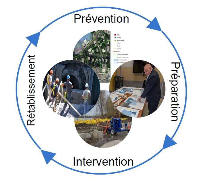
6.2.1      Coverage of Flooded Sectors by Emergency Services ......................................... 26
           6.2.2      Logistical Support......................................................................................................... 26
           6.2.3      Dykes ............................................................................................................................. 27
           6.2.4      Protecting infrastructure.............................................................................................. 28
           6.2.5      Flooded Homes and Evacuations.............................................................................. 28
           6.2.6      Traffic Management..................................................................................................... 29
   6.3 ASSISTANCE TO FLOOD VICTIMS ................................................................................................ 30
           6.3.1      Emergency Shelter and Multiservice Assistance Centres ..................................... 30
           6.3.2      Data Compilation.......................................................................................................... 31
   6.4 COMMUNICATION ......................................................................................................................... 31
           6.4.1      With the Media and Public.......................................................................................... 31
           6.4.2      With Flood Victims ....................................................................................................... 32
           6.4.3      At-Risk Persons............................................................................................................ 33
   6.5 HUMAN AND FINANCIAL RESOURCE MANAGEMENT................................................................... 33
           6.5.1      Psychological Assistance to Personnel .................................................................... 33
           6.5.2      Relief/Mutual Assistance/Resource Sharing............................................................ 34
           6.5.3      Financial Management................................................................................................ 34
   6.6 VOLUNTEER SERVICES AND ASSISTANCE FROM RESIDENTS ................................................... 35

7 RECOVERY.............................................................................................................. 36

   7.1 OSCAM’S ROLE .......................................................................................................................... 36
   7.2 RETURN TO HOMES/BUSINESSES ............................................................................................... 36
   7.3 EQUIPMENT CLEAN-UP AND RECOVERY .................................................................................... 37
           7.3.1      Management of Waste and Unused Materials ........................................................ 37
           7.3.2      Clean-Ups ..................................................................................................................... 37
   7.4 POST-FLOOD RECONSTRUCTION AND LAND-USE PLANNING ................................................... 38
           7.4.1      Government Order ....................................................................................................... 38

8 CONCLUSION.......................................................................................................... 41

9 SUMMARY OF RECOMMENDATIONS ................................................................... 42

APPENDICES ............................................................................................................... 53

2017 Flooding—Event Report                                                                                                                                4
ABBREVIATIONS AND ACRONYMS

      CAM                    Centre d’aide multiservices (multi-service assistance centre)
                             Centre de coordination des mesures d’urgence (emergency measures
      CCMU
                             coordination centre)
      CEHQ                   Centre d’expertise hydrique du Québec (Québec hydrological expertise centre)

      CGMU                   Centre de gestion de la mobilité urbaine (urban mobility management centre)

      CF                     Centre de fonctionnement (operations centre)

      CGC                    (Cellule de gestion de crise) (crisis management cell)

      CHU                    Centre d’hébergement d’urgence (emergency shelter)
                             Centres intégrés universitaires de santé et services sociaux (integrated
      CIUSSS
                             university healthcare and social service centres)
      CLSC                   Centres locaux de services communautaires (local community service centres)

      CMM                    Communauté métropolitaine de Montréal (Montréal metropolitan community)
                             Centre des opérations d’urgence des missions d’agglomération (agglomeration
      COUA
                             emergency operations centre)
                             Centre des opérations d’urgence des missions d’agglomération (emergency
      COUM
                             operations centre for borough missions)
                             Centre des opérations d’urgence sur le site (on-site emergency operations
      COUS
                             centre)
                             Centre des opérations d’urgence de ville (municipal emergency operations
      COUV
                             centre
      CR                     Canadian Red Cross

      SC                     Site coordinator

      BM                     Borough manager

      GM                     General manager
                             Direction de la sécurité civile et de la résilience (civil protection and resilience
      DSCR
                             division)
      DRSP                   Direction régionale de santé publique (regional public health division)

      CAF                    Canadian Armed Forces

      ARLUPD                 Act respecting land use planning and development

      EMS                    Emergency management software

      MAMOT                  Ministère des Affaires municipales et de l’Occupation du territoire
                             Ministère du Développement durable, de l’Environnement et de la Lutte contre
      MDDELCC
                             les changements climatiques

2017 Flooding—Event Report                                                                                          5
Abbreviations and acronyms (suite)

      MSP                    Ministère de la Sécurité publique
                             Organisation régionale de la sécurité civile (regional civil protection
      ORSC
                             organisation)
                             Organisation de sécurité civile de l’agglomération de Montréal (Montréal
      OSCAM
                             agglomeration civil protection organisation)
                             Organisation de la sécurité civile du Québec (Québec civil protection
      OSCQ
                             organisation)
                             Plan métropolitain d’aménagement et de développement—Metropolitan Land
      PMAD
                             Use and Development Plan
      PC                     Command post

      PPI                    Plan particulier d’intervention (emergency response plan)

      PPRLPI                 Protection Policy for Lakeshores, Riverbanks, Littoral Zones and Floodplains
                             Plan de sécurité civile de l’agglomération de Montréal (Montréal agglomeration
      PSCAM
                             civil protection plan)
      RDP                    Rivière des Prairies
                             Regroupement des organismes humanitaires et communautaires pour les
                             mesures d’urgence à Montréal (association of humanitarian and community
      ROHCMUM
                             organisations for emergency measures in Montréal)

                             Schéma d’aménagement et de développement (land use and development
      SAD
                             plan)
      SDÉ                    Service de développement économique (economic development department)

      SIM                    Service de sécurité incendie de Montréal (Montréal fire department)
                             Service des infrastructures, de la voirie et des transports (department of
      SIVT
                             infrastructure, roads and transportation)
      SMVT                   Service de mise en valeur du territoire (land-use development department)

      SPVM                   Service de police de la Ville de Montréal (Montréal police department)

      STM                    Société de transport de Montréal (Montréal transit authority)

      PW                     Public works

      US                     Urgences - santé (emergency health services)

2017 Flooding—Event Report                                                                                    6
1 EXECUTIVE SUMMARY
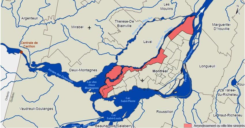
The Montréal agglomeration, like more than 260 Québec municipalities, suffered severe flooding in the
spring of 2017 - the worst since 1976. These floods struck many boroughs and coextensive municipalities
along Lac des Deux-Montagnes, Rivière des Prairies, Lac Saint-Louis and the St. Lawrence River. It was
clearly the worst disaster involving civil protection services to have hit Montréal since the 1998 ice storm.
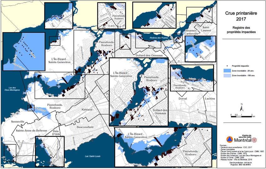
These events caused damage—occasionally severe—to property and to some infrastructure. Over 430
homes were flooded and some 1,100 residents displaced in the boroughs of L’Île-Bizard–Sainte-
Geneviève, Pierrefonds-Roxboro, Ahuntsic-Cartierville, Rivière-des-Prairies–Pointe-aux-Trembles
boroughs and the coextensive municipalities of Ville de Sainte-Anne-de-Bellevue and Village de
Senneville.
The seasonal flood watch by the DSCR (Direction de la sécurité civile et de la resilience) began March
15, 2017 and continued through to April 6, 2017, when the Montréal agglomeration’s civil protection plan
(PSCAM) shifted to STANDBY mode as a response to flood thresholds being reached and in view of
weather forecasts by the CEHQ (a unit of the MDDELCC).
Following a swift rise in water levels, the PSCAM was placed in RESPONSE mode from May 3 to 19.
2017, resulting in the mobilisation of OSCAM (Organisation de sécurité civile de l’agglomération de
Montréal —Montréal agglomeration civil protection organisation) at the CCMU (Centre de coordination
des mesures d’urgence—emergency measures coordination centre) and operations centres. The ORSC
(Organisation régionale de sécurité civile—Regional civil protection organisation) and the Canadian
Armed Forces (CAF) provided support to OSCAM’s staff at the CCMU. A total of some 2,000 responders
(fire fighters, police officers and blue and white collar workers, as well as professionals from the city and
its coextensive municipalities) were deployed, either in the field and the operations centres.
The unique access to the island sector of Mercier, in the L’Île-Bizard–Sainte-Geneviève borough, was
closed following its inundation. With emergency services unable to reach the island, the coordinator of
civil protection issued an evacuation order on May 5, 2017, at the height of the response. Many residents
refused to comply and remained in their homes. Lack of access to the island posed a major challenge to
emergency responders. The issue was partially resolved by establishing a round-the-clock land and water
watch by Montréal police and fire fighters. This watch ensured emergency responses for calls to first
responders, as well as to reports of break-ins, vandalism or fire. The emergency response coordinator
then authorised those residents who wished it to remain in their homes.
In view of this extraordinary situation, the severity of the flooding and the scale of the disaster area, the
1
Mayor of Montréal announced a two-day state of emergency on May 7, as per the Civil Protection Act.
On May 9, the Agglomeration Council issued a five-day extension of the state of emergency, extending
the status to May 14.
The various measures implemented under this state of emergency by the city and the coordinator of civil
protection for the Montréal agglomeration were aimed at controlling flooding, ensuring resident safety and
protecting property and infrastructure.
This report’s recommendations—based on observations, lessons from the response and a feedback
session with responders—are intended to make the Montréal agglomeration more resilient to flooding, by
improving responder preparedness and our overall knowledge of with respect to this risk.
1
CQLR, c. S-2.3
2017 Flooding—Event Report 7The report’s recommendations are designed to meet six goals: 1) Improve knowledge of potential risks and impacts so that mitigation measures can be proposed. Meeting this goal will involve updating and expanding flood zone maps, while developing and defining a land-use policy for flood zones. 2) Improve the state of preparedness of different responders with respect to floods by updating the COUS (on-site emergency operations centres), the coordination/management structure, training content and requirements, the flood response plan (PPI — Inondations) and related operational factors as well as planning more extensively for the RECOVERY phase. 3) Improve coordination among responders by considering the possibility of establishing a faster and more flexible process for approving requests for government assistance (such as deploying the Canadian Armed Forces). 4) Improve communication with victims, at-risk persons and the general population, by updating the communication plan and improving flood response tools. 5) Improve support for Montréal agglomeration workers by developing emergency measures workforce relief plans for the boroughs and coextensive municipalities. 6) Improve preparedness of the agglomeration’s corporate citizens to optimise recovery with respect to commercial activities and places of business. 2017 Flooding—Event Report 8
2 Making Montréal a Flood-Resilient Community
The Montréal agglomeration, like more than 260 Québec municipalities, suffered severe flooding in the
spring of 2017 - the worst since 1976. Many boroughs and coextensive municipalities along the
waterways surrounding the Montréal agglomeration were hit by Montréal’s worst disaster since the 1998
ice storm.
As Québec’s largest city, Montréal must not only be able to prevent or cope with extreme events, but
respond to them proactively, mitigating risk to residents and organisations, while providing for essential
needs and ensuring quality of life.
This report has been prepared to highlight lessons learned from the 2017 spring floods and, as such,
accompany Montréal in its efforts to become more resilient. These lessons will allow recommendations
with respect implementing preventive measures, improving the Montréal agglomeration’s preparedness
and enhancing its disaster-recovery abilities.
The recommendations of this report, based on lessons learned from the flood response, as well as a
feedback session with responders, are listed according to their related risk-management phase:
PREVENTION, PREPARATION, RESPONSE or RECOVERY.

-   Taking preventive action will enable Montréal to plan its urban development in a way as to minimise
    hazards, maintain essential community services and limit impact in at-risk sectors.
-   “Preparing” means defining activities that would mitigate the identified impacts, based on risk assessment
    and evidence. Response can then be formulated by adapting emergency measure plans, response
    procedures, training and simulations accordingly.
-   Taking effective action so Montréal can engage in a coordinated response to such events.
-   Recovering quickly from a disaster to support the resumption of Montréal’s economic activities and rebuild
    damaged infrastructure, while restoring pre-disaster living, economic and social conditions.
-   Engaging in broader, multiagency planning, enabling Montréal to mitigate or avoid disasters and identify or
    reduce social, economic and cultural factors that could impair effective response.

2017 Flooding—Event Report                                                                                   9
3 Background
3.1 Spring Floods
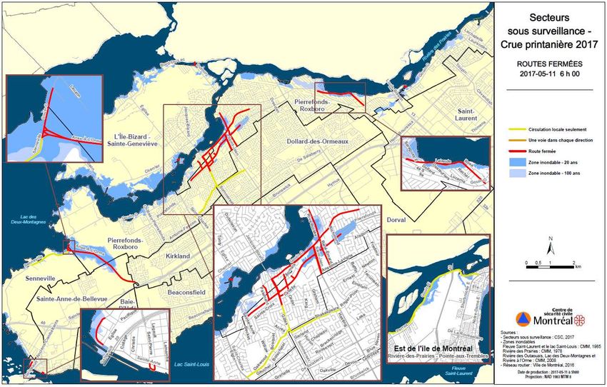
On the night of May 2-3, 2017, water levels bordering the boroughs of L’Île-Bizard–Sainte-Geneviève, de
Pierrefonds-Roxboro, Ahuntsic-Cartierville, Rivière-des-Prairies–Pointe-aux-Trembles, as well as Ville de
Sainte-Anne-de-Bellevue and Village de Senneville, rose abruptly, triggering Montréal’s worst floods since
1976 (see map of affected sectors in Appendix 1).
These events resulted from a juxtaposition of meteorological and hydrological factors. Large snowfalls
that had accumulated in catchments throughout the winter melted quickly following a sudden rise in
2
temperature and heavy April-May rains. Runoff to rivers and lakes boosted flow rates in tributaries of the
Ottawa River and the Carillon Dam—the only dam controlling the Ottawa River’s flow. This was followed
3
by a considerable rise in water levels of Lac St-Louis, Lac des Deux-Montagnes and Rivière des Prairies.
3.2 Deploying OSCAM
3.2.1 Mobilisation Timeline
According to the Montréal agglomeration civil protection plan (PSCAM) and flood response plan (PPI —
Inondations), members of OSCAM (Organisation de sécurité civile de l’agglomération de Montréal—
Montréal agglomeration civil protection organisation) were gradually mobilised and deployed from March
15, 2017 until they were fully deployed from May 3 to 16.
2
According to Environment Canada, the Montréal agglomeration received heavy rainfall in April and May 2017:
• April: 156 mm (normal = 68 mm), including 80 mm from April 4 to 7.
• May 1 to 16: 82 mm (normal = 78 mm), including 75 mm from May 1 to 7.
3
See Table 3 in Appendix 2 for maximum flow rates and water levels in the spring of 2017.
2017 Flooding—Event Report 10The DSCR’s spring flood watch began March 15, 2017. On April 6, 2017, following upwardly revised
hydrological forecasts by the CEHQ (MDDELCC) and forecasted rainfall quantities, the Montréal
agglomeration’s coordinator of civil protection set the PSCAM to STANDBY mode because the possible
impact on residents.
Once the PSCAM went to STANDBY, various preventive measures, such as sand bag preparation, were
applied locally by the boroughs and coextensive municipalities to lessen the potential impact of flooding
on different sectors.
The CCMU (Centre de coordination des mesures d’urgence—emergency measures coordination centre)
was opened for three different periods: April 7-8, April 19-21 (in ALERT mode) and May 3-19 in
RESPONSE and RECOVERY modes. The CCMU was open 24/7 for 17 days in a row, from May 3 to 19.
4
Between May 3 and 18, the agglomeration missions, the Canadian Armed Forces (CAF) and the ORSC
(Organisation régionale de sécurité civile—regional civil protection organisation) were mobilised at the
CCMU, on in their operations centres, to coordinate activities within the agglomeration.
Some 2,000 responders were deployed, including firefighters, police officers, blue and white collar
workers and professionals from the city and coextensive municipalities. Crews from DRSP, US
(Urgences-santé—emergency health services) and CIUSS (centres intégrés universitaires de santé et
services sociaux—integrated university healthcare and social service centres) also worked with the SIM
(Montréal fire department) in inspecting flooded residences.
Table 1: Timeline of OSCAM Deployment and Declaration of State of Emergency
Month Date Event
March 15 Start of DSCR WATCH.
4 Upwardly revised forecasts by the CEHQ, based on meteorological
conditions.
6 PSCAM set to STANDBY mode.
7-8 PSCAM set to ALERT mode.
CCMU opened in reduced mode.
April
9-17 PSCAM set to STANDBY mode (reduced water levels and flow
rates)
18-23 PSCAM set to ALERT mode.
CCMU opened April 19-21 in reduced mode.
April 23-May 1 Set to STANDBY mode.
2 Set to ALERT mode.
3-15 Set to RESPONSE mode.
CCMU completely opened 24/7.
7 Declaration of state of emergency.
Arrival of Canadian Armed Forces
May 9 State of emergency extended.
14 State of emergency ended.
16 PSCAM set to RECOVERY mode.
19 CCMU closed.
20 and 27 Cleanup operations.
May 22 Withdrawal of armed forces.
4
Administrative and logistical support, communications, essential infrastructure, water, transport of people, peace and order, saving lives and protecting
property, health and the environment.
2017 Flooding—Event Report 113.2.2 Declaration of State of Emergency
In view of the extraordinary situation resulting from spring flooding, the severity of the disaster and the
magnitude of the area affected, the Mayor of Montréal declared a two-day state of emergency on May 7,
5
as per the Civil Protection Act. The Agglomeration Council extended the state of emergency for five days
on May 9, extending the status to May 14.
The declaration of a state of emergency gave the civil protection coordinator additional powers:
1. Controlling access (or applying special regulations) to roads and the sectors in question.
2. Granting authorisations and waivers in areas falling under municipal jurisdiction for a duration
deemed necessary to allow for prompt and effective response.
3. When no other protective measures were available, ordering the evacuation of people from all or
part of a given sector - in accordance with recommendations from public health officials - as well
as seeing to their needs including, if they had no assistance, providing for their lodging, food,
clothing and safety.
4. Requesting assistance from able residents in aiding response crews.
5. Requisitioning, within territorial limits, necessary private support and accommodations, other than
those needed for the deployment of a civil protection plan adopted under this chapter or Chapter
VI.
6. Approving contracts and making the expenditures the coordinator deems necessary.
3.3 PROFILE OF IMPACT AND CONSEQUENCES
Spring flooding affected more than 1,100 people and caused damage—occasionally major—to properties,
possessions and some infrastructure.
Impact on people
- More than 1,100 flood victims.
- Order to evacuate Île Mercier.
- Voluntary evacuation of many homes.
Impact on property and possessions
- More than 430 residences flooded.
Impact on essential infrastructure and other public/private infrastructure
- Closure of a fire station, a Montréal police (SPVM) station and a road in Pierrefonds-Roxboro
borough.
- Rerouting of more than 8 STM bus lines because of street closures.
- Closure of many bridges, overpasses and streets:
o Chemin de l’Anse-à-l’Orme
o Chemin Senneville
o Pont Galipeault (Highway 20)
o Pont de l’île Mercier
o Pont Oakridge
o Boulevard Gouin
o Boulevard Saint-Jean
o Boulevard Pierrefonds
5
CQLR, c. S-2.3
2017 Flooding—Event Report 12- Evacuation of three healthcare centres and monitoring of several other sites by the CIUSSS du
Centre-Sud, which oversees emergency measures for Montréal agglomeration healthcare
institutions:
o Pavillon Albert-Prévost (6555, boul. Gouin Ouest)
o Centre hospitalier de soins de longue durée (CHSLD) Vigi Pierrefonds (14755, boul. de
Pierrefonds)
o Centre d’hébergement Notre-Dame-de-la-Merci (555, boul. Gouin Ouest)
o Résidence Berthiaume-du-Tremblay (1635, boul. Gouin Est)
o CLSC Laurendeau (1725, boul. Gouin Est)
o Centre jeunesse Rose-Virginie-Pelletier (6469, boul. Gouin Ouest)
o CLSC Pierrefonds (13800, boul. Gouin Ouest)
o CHSLD Château sur le lac (16289, boul. Gouin Ouest)
- Closure of many shops
- Closure of many schools
3.4 Financial Impact
The flooding gave rise to massive, unanticipated expenditures for the affected boroughs and coextensive
municipalities, particularly in deploying protective measures, opening reception and information centres
for flood victims, opening emergency shelters and employee overtime.
6
The Montréal agglomeration spent an unplanned $8,014,316.80 because of the 2017 spring flooding.
6 Service des finances, 2017-11-23
2017 Flooding—Event Report 134 Prevention
Prevention is “the set of permanent measures aimed at eliminating risk, as well as reducing the chance of
7
unanticipated hazards and mitigating their potential impact” and remains the key focus of investment in
boosting community resiliency. Prevention measures can be structural (dykes) or non-structural (land-use
8
policies).
Because watercourses can be complex and hydrological forecasts uncertain, many conventional
solutions, such as dam construction, have often yielded unexpected and undesirable results, such as
habitat fragmentation of watercourses and wetlands, transfer of impacts to other sectors and sometimes
an even greater impact on the protected site if the solution fails. In addition, forecast uncertainty has now
been amplified by climate change.
To improve Montreal’s resilience to floods, we must start by improving our understanding of Montréal’s
hazard probabilities and existing vulnerabilities. A better understanding of flood risk will enable us to
improve our preventative measures by adapting our in land-use planning and implementing appropriate
structural approaches and green infrastructure projects.
4.1 Montréal Agglomeration Floodplain Mapping
The floods highlighted opportunities for more accurate forecasting of changes in watercourses and their
resulting impact.
Several technical reports are currently used in calculating 2-year, 20-year and 100-year flood benchmark
levels for their respective watercourses:
- Rapport technique de 1985 pour le fleuve Saint-Laurent et le lac Saint-Louis [1985 Technical
Report for the St. Lawrence River and Lac Saint-Louis].
- Rapport technique de 1990 pour le tronçon Varennes-Grondines [1990 Technical Report for the
Varennes-Grondines Navigation Corridor].
- Rapport technique de 2006 pour la rivière des Prairies (RDP) [2006 Technical Report for Rivière
des Prairies].
- Rapport technique de 2006 pour la rivière des Outaouais et le lac des Deux-Montagnes, incluant
la rivière à l’Orme [2006 Technical Report for the Ottawa River and Lac des Deux-Montagnes,
Including Rivière à l’Orme].
The CMM [Montréal Metropolitan Community] used the 2006 technical reports in mapping the floodplains
of Lac des Deux-Montagnes and Rivière à l’Orme in 2008. However, the floodplains of Rivière des
Prairies (RDP) were not mapped. Emergency response services still use the RDP floodplain maps, which
9
were produced by the CEHQ and based on benchmark levels defined in its now-outdated 1978 technical
report. Updated maps are, accordingly, required.
7
Ministère de la Sécurité publique (2008). Pour planifier la réponse au sinistre – Guide à l’intention des municipalités, Gouvernement du Québec, September
2008, 98 pages, Online at:www.securitepublique.gouv.qc.ca/fileadmin/Documents/securite_civile/publications/guide_reponse_sinistre/guide.pdf
8
Public Safety Canada (2015). About Disaster Mitigation, Government of Canada, Online: www.publicsafety.gc.ca/cnt/mrgnc-mngmnt/dsstr-prvntn-mtgtn/bt-
dsstr-mtgtn-en.aspx
9
”In 2017, following organisational restructuring, the CEHQ’s units were placed under the Ministère du Développement durable, de l’Environnement et de la
Lutte contre les changements climatiques.”
2017 Flooding—Event Report 14In addition to updating maps based on the latest technical reports, consideration should be given to
climate change-induced uncertainty, which could influence the flood probabilities.,. Furthermore, the
impact of increased urbanisation of catchment areas on local flow should be considered. Maps should
not only show flood zones, but the evolution of such zones and their vulnerability to flooding. The flood
management strategy should accordingly be based on comprehensive maps that are regularly updated
and include more than just probabilistic levels based on historical events
The floods of 2017 also provided a chance to collect new data and acquire fresh knowledge that could be
used to prevent the impact of future flooding:
- Real-time data on watercourse levels and flows.
- A moving potential inundation line determined by various techniques, with results applied to
identifying Montréal’s flood-risk areas.
- Identification of the most vulnerable residences and infrastructure.
This new information and knowledge should be used to create flood-risk maps.
Recommendations
1. Finalise Montréal’s hazard maps, incorporating knowledge acquired from the 2017 floods and
determine the value of including these maps in the Schéma d’aménagement et développement
(SAD—Land Use and Development Plan). Then, contribute to the formulation of a technique for
identifying the Montréal archipelago’s flooding zones. In particular, we recommend the following
measures:
a. Task the Division de la géomatique of the Direction des infrastructures, which is part of the
Service des infrastructures, de la voirie et des transports) (SIVT), in conjunction with the
Service de mise en valeur du territoire (SMVT), with completing hazard maps based on the
2006 CEHQ report, while integrating knowledge acquired from the 2017 floods.
b. Task the Direction de l’urbanisme of the Service de mise en valeur du territoire) (SMVT) with
assessing the value of incorporating maps produced by the Division de la géomatique of the
Direction des infrastructures, which is part of the Service des infrastructures, de la voirie et des
transports) (SIVT) in the SDD (Schéma d’aménagement et développement—Land Use and
Development Plan).
c. Task the Direction de l’urbanisme of the Service de mise en valeur du territoire (SMVT) with
working conjunction with the CMM to develop a uniform technique for identifying flood zones
throughout the archipelago.
2. Task the DSCR, with the support of the Division de la géomatique of the Direction des
infrastructures, which is part of the Service des infrastructures, de la voirie et des transports (SIVT),
with developing a risk map based on catchment evolution and uncertainty due to climate change, to
predict the impact on vulnerable areas of the agglomeration and identify adaptation options.
4.2 Land-Use Planning as a Preventive Measure
Land-use planning can play an important role in mitigating the risk of spring floods, by reducing the
exposure of people, property and infrastructure to the occurrence of floods as well as to their potential
intensity. Adequate planning must, however, be based on scientific knowledge of the phenomenon, with
maps drawn in line with such knowledge. The identification of floodplains and maps showing them can be
used to create and apply a specific regulatory framework to define permitted uses and types of
construction, and the conditions to which they will be subjected. This regulatory framework must then be
incorporated in land-use planning documents and planning by-laws for the municipalities in question.
2017 Flooding—Event Report 15There are a variety of flood risk management strategies for cities. They range from complete protection
for the built environment to respect for watercourse behaviour. Historically, however, the general trend
has been to protect the urban setting by encroaching on shorelines, floodplains and occasionally the
coastline, with sometimes disastrous consequences.
Sealing surfaces catchment soil surfaces through development can alter their hydrological regime and
increase volumes of water draining into watercourses. Development can also destroy wetlands that are
part of the watercourses’ hydrological regime and act as buffers by absorbing excess water.
The spring flooding of 2017 raised a number of issues concerning flood risk knowledge and land-use
planning:
- Some flooded sectors were in low-velocity zones (20-100 year flood zones) or were located
outside low-velocity zones, while some high-velocity zones (0-20 year flood zones) were
unaffected.
- Some sensitive uses were present in low-velocity zones:
o Certain healthcare institutions had to be evacuated on a precautionary basis because of
the vulnerability of patients residing in them.
o Sites critical to emergency response measures, such as a fire station, a local police
station and a municipal roadwork station were closed and their activities relocated.
- Essential infrastructure, bridges, overpasses and roads had to be closed, include the Pont de l’Île
Mercier, the only access to the island’s residential community.
Floodplain Regulations
The MDDELCC’s Protection Policy for Lakeshores, Riverbanks, Littoral Zones and Floodplains (PPRLPI),
established a regulatory framework for activities in these sectors. The policy was adopted in 1987 to
protect lakes and waterways, as well, more generally, to protect “water” because of developmental
pressures on shorelines, the coast and floodplain threatening lake and waterway quality.
The Act respecting land use planning and development (ARLUPD), which serves as the legal framework
for Québec’s land-use planning, obliges regional county municipalities (RCMs) and local municipalities to
incorporate the PPRLPI in their planning documents and town-planning by-laws. Furthermore, the
ARLUPD requires that planning documents take natural constraints into account. Identification of such
zones inevitably results in limits on development, with a direct impact on economic development.
PPRLPI regulations are minimal, which means RCMs and municipalities can opt for stricter standards.
They can even submit a management plan for a shoreline, coastline or floodplain in response to special
situations in view of the local environment and the extent to which natural shorelines and floodplains have
10
been eliminated.
10 MAMOT (2017). Outils de protection de l’environnement, La protection des rives, du littoral et des plaines inondables, Guide La de prise de décision en
urbanisme, Viewed July 21, 2017, online at: www.mamot.gouv.qc.ca/amenagement-du-territoire/guide-la-prise-de-decision-en-urbanisme/protection-de-
lenvironnement/protection-des-rives-du-littoral-et-des-plaines-inondables/
2017 Flooding—Event Report 16The CMM (Communauté métropolitaine de Montréal) is responsible for creating and implementing a
PMAD (Plan métropolitain d’aménagement et de développement—Metropolitan Land Use and
Development Plan). A PMAD should, in particular, identify major constraints shared by different RCMs
that could influence risks or trigger disasters. The PMAD SHOULD also incorporate the PPRLPI’s minimal
standards requiring RCMs to include them in their SADs (land use and development plans).
The CMM’s current PMAD includes the objective of “3.2 Protecting Greater Montréal’s shorelines,
coastline and floodplains,” with the first criterion (3.2.1) being “floodplain identification.” These guidelines
highlight the fact the proper land-use planning and effective environmental protection are based on
knowledge of the floodplains.
The Montréal agglomeration’s SAD incorporates the PPRLPI’s requirements and INCORPORATES
floodplains for each of its watercourses, along with mapping available for some agglomeration shorelines.
In view of the applicable regulatory framework, a metropolis-wide approach to the hydrological regime
and an updated set of regulations for the agglomeration is needed, particularly including the PPRLPI’s
option of imposing stricter standards or formulating a floodplain management plan that reflects issues
specific to the Montréal agglomeration.
Recommendation
3. Task the Direction de l’urbanisme du Service de la mise en valeur du territoire, in conjunction with
the DSCR and all other applicable Montréal corporate departments with defining a floodplain
management policy and formulating long-term solutions reflecting existing risks, covering such
issues as acquiring land in floodplains, protecting more aquatic environments, defining measures for
minimising surface sealing in catchments, etc.
4.3 Structural and Green Infrastructural Measures
Despite new knowledge of flood risks, adequate mapping and a regulatory framework tailored to
Montréal’s actual shorelines and floodplains, some parts of the island may remain at risk to possible
flooding.
For this reason, the feasibility of installing structural mitigation measures (permanent dykes) and green
infrastructure (such as green spaces) could be considered to protect people, buildings and infrastructure.
Implementing such initiatives involves many technical, financial and legal constraints:
- Every dyke construction site or green infrastructure facility should be initially identified according
to the intentions of the various stakeholders, such as city or the borough in question, the
municipal corporate department concerned and the public.
- Once a potential site has been identified, the technical feasibility of a particular structure or
facility, as well as its environmental impact up- and downstream of the site, should be evaluated
by a variety of specialists.
- Depending on the site’s location, certain measures could require an environmental impact
assessment.
- The cost of dyke maintenance and management should be estimated and accepted by the
stakeholders and should be less than the cost of damages that may be caused by another flood.
As such, the implementation of such measures must be the result of strategic planning and of
appropriately identified sites in an effort to avoid creating a false sense of security in the public or
development in vulnerable areas.
2017 Flooding—Event Report 17Recommendation
4. Task the DSCR and the Bureau de la résilience, in conjunction with the Service des infrastructures,
de la voirie, et des transports (SIVT), the Service du développement économique (SDÉ), the Service
de l’eau, the Service de l’environnement, the Service de la mise en valeur du territoire (SMVT) and
all other relevant municipal corporate departments, with planning resilient techniques, standards and
construction, along with green infrastructure.
4.4 Planning the Recovery of Businesses and Business Locations
Despite the rollout of business continuity initiatives, some companies remain more vulnerable to a
disaster than others. Small and medium-sized businesses often lack the know-how and resources to
reduce risk. The city must accordingly play a role in supporting these local businesses so they can rapidly
resume activity following a disaster.
Recommendation
5. Task the DSCR and the Bureau de la résilience, in conjunction with the Service du développement
économique (SDÉ) with planning a post-disaster recovery phase for commercial activities and places
of business.
2017 Flooding—Event Report 185 Preparation
11
Preparation is the set of activities and measures aimed at enhancing disaster response capabilities.
This phase includes planning, creation of a resource inventory and implementation of exercise programs
12
and training sessions. It also serves in developing up-to-date, effective emergency measure plans.
Making Montréal a resilient city requires applying the effort needed to ensure continuous improvement of
the agglomeration’s general preparedness—which means preparedness of the public, municipal
corporate departments, boroughs and coextensive municipalities. The floods of 2017 provided an
opportunity to reassess our preparedness and preparedness efforts, and to identify potential changes in
both areas.
To respond effectively, Montréal needs significant preparation and planning by the different missions of
OSCAM (civil protection organisation). Officials must also devote the necessary efforts to enhance their
departments’ preparedness.
Recommendation
6. That agglomeration mission directors report on their preparedness to the Direction générale, with
this responsibility included in their job description. Ensure that an administrative framework applies
to this recommendation.
5.1 The Montréal Agglomeration’s Civil Protection Plan (PSCAM)
Established in conjunction with the city’s corporate departments, as well as the Montréal agglomeration’s
boroughs and coextensive municipalities, the PSCAM constitutes the cornerstone of civil protection
planning and strategic coordination. It provides general rules on the strategic coordination structure and
consists of the agglomeration and local mission plans, as well as emergency response plans. It can be
activated for three alert and mobilisation levels—STANDBY, ALERT and RESPONSE.
The agglomeration’s 10 mission plans fall under the responsibility of Montréal’s corporate departments,
quasi-municipal entities and non-municipal organisations. Montréal’s boroughs and coextensive
municipalities are responsible for the four local mission plans.
Table 2: Agglomeration and Local Missions
Agglomeration Missions Local Missions
- Protecting lives and property - Assistance to flood victims
- Peace and order - Communications
- Healthcare - Public works
- Transportation of people - Administrative and logistical support
- Essential infrastructure
- Water
- Environment
- Communications
- Logistical support
- Administrative support
11
Ministère de la Sécurité publique (2008) Approche et principes en sécurité civile, Gouvernement du Québec, 70 pages, Online
at:www.securitepublique.gouv.qc.ca/fileadmin/Documents/securite_civile/publications/approche_principes/approche_principes.pdf
12
Centre de sécurité civile. La gestion du risque, 4 phases de gestion des risques, Ville de Montréal, Online at:
ville.montreal.qc.ca/portal/page?_pageid=7637,82029670&_dad=portal&_schema=PORTAL
2017 Flooding—Event Report 192017’s spring floods demonstrated the importance of the RECOVERY phase following a disaster. Since
the PSCAM provide little detail about recovery, the DSCR and SIM’s Centre de services – Expertise et de
développement de prevention had to develop a spontaneous recovery plan with respect to residents
reoccupying their residence. This plan can now serve as a useful model in developing permanent PSCAM
standards for recovery.
It was also determined, based on the events of 2017, that the coordination of emergency measures is key
in maintaining an integrated and holistic view of events which, in turn, aids in better anticipating their
outcome. As such, the RECOVERY phase must also be planned as a coordinated effort with all
appropriate responders.
Recommendation
7. Task the DSCR and SIM, in conjunction with OSCAM’s partners, with updating and modifying the
PSCAM based on the lessons of 2017 and past Plan activations. These changes should include
13
updating alert and mobilisation levels to include a recovery phase, accompanied by clarified roles
and responsibilities.
5.2 Flood Response Plan
The flood response plan (PPI — Inondations) deployed for the 2017 floods was prepared to ensure
monitoring of Montréal’s watercourses and to provide an effective, coordinated response to emergencies
resulting from high waters. The plan delineates mobilisation indicators and responder roles and
responsibilities.
Despite the set of preventive actions performed and communications disseminated in conjunction with
internal and external municipal partners during STANDBY and ALERT periods, the Montréal
agglomeration still faced a substantial and unpredictable rise in water levels in the night of May 2-3. The
actual situation far exceeded hydrological forecasts, requiring a rapid deployment of personnel to limit
impacts.
During the RESPONSE phase, directives within the PPI were at times questioned, particularly with
respect to the different roles and responsibilities of the boroughs, coextensive municipalities and
emergency services operating in the field.
5.2.1 Mobilisation Monitoring Indicators
Water flows at specific sites (dam and measuring stations) serve as flood response plan (PPI —
Inondations) indicators for setting PSCAM activation levels. OSCAM’s responses were based on real-time
data and the 48-hour CEHQ forecasts. However, the 2017 flooding far exceeded its predicted impact
suggesting the need for longer-range (more than 48-hour) forecasts that would permit better preparation
actions by responders.
It was also observed that, for many responders, the flows recorded at dams and used as mobilisation
criteria failed to suggest the actual field impact of rising water levels. We must, accordingly, be able to
translate recorded flows into water levels.
13
Please refer to the Recovery section for additional information on this topic.
2017 Flooding—Event Report 205.2.2 Support Tools
Mobilised responders developed a variety of tools throughout deployment to ensure effective
management of the response phase, particularly for tracking orders of equipment, while keeping track of
number of victims and flooded homes, as well as the return of victims to their homes, plus a street
reopening procedure. These tools proved their worth in the response to flooding and should be enhanced
and standardised, so they can be incorporated into the PPI for future use.
Recommendations
8. Task the DSCR, in conjunction with OSCAM’s partners, with modifying and improving the flood-
response plan (PPI — Inondations) based on recent lessons learned. This change should include
updating indicators, clarifying roles and responsibilities, enhancing support tools and developing a
specific RECOVERY phase section.
9. Task the DSCR, following modification of the flood-response plan (PPI — Inondations) with
developing and deploying a training and exercise plan for all responders concerned, including
changes to the flood response plan and to the roles and responsibilities of the different missions.
10. Task the DSCR, in conjunction with the various bodies concerned (Ministère de la Sécurité
publique—MSP, MDDELCC, Environment Canada, etc.), with updating water flow and level
forecasting procedures and mechanisms, to improve short-, mean- and long-term decision-making.
2017 Flooding—Event Report 216 Response
The response phase of risk management constitutes intervention in actual or anticipated disasters. It
represents the application, as well as any adaptation, of measures and resources planned during the
14
preparatory phase, according to the nature and scope of the disaster.
The next section will discuss actions, observations and recommendations pertaining to PSCAM activation
phases, as well as topics relating to coordination of responders, protection of the public, property and
infrastructure, assistance to flood victims, communications, management of human and financial
resources and management of offers of assistance from volunteers and private citizens.
6.1 Coordination Among Stakeholders
The PSCAM provides for several disaster-management decision centres: a crisis management cell
(CGC—cellule de gestion de crise), an emergency measures coordination centre (CCMU—Centre de
coordination des mesures d’urgence), an on-site emergency operations centre (COUS—centre des
opérations d’urgence sur le site), borough (COUA) and city (COUV) emergency operations centres and
agglomeration mission emergency operations centres (COUM), as well as command posts (PCs) and
operations centres (CFs) (Figure 1). Each of these decision centres has a director, a response site and
specific responsibilities, while corresponding to distinct management levels (political, strategic, tactical
and operational).
Figure 1: OSCAM Deployment Coordination Levels
14
Ministère de la Sécurité publique (2008) Approche et principes en sécurité civile, Gouvernement du Québec, 70 pages, Online at:
www.securitepublique.gouv.qc.ca/fileadmin/Documents/securite_civile/publications/approche_principes/approche_principes.pdf
2017 Flooding—Event Report 226.1.1 Emergency Measures Coordination Centre (CCMU)
The CCMU (Centre de coordination des mesures d’urgence), which is headed by Mr. Bruno Lachance,
Coordinator of Civil Protection for the Montréal Agglomeration, is the strategic decision centre for the
coordination of the Montréal agglomeration’s emergency response. The CCMU was in operation 24/7
during flooding from May 3 to 19.
The PSCAM provides for a management cycle that can be tailored to events. To ensure adequate and
regular information transfers during flooding, the following management cycle was established at the
CCMU:
- Overview of the situation to the coordinator by 7:00 a.m.
- Coordination meeting with representatives of missions of the agglomeration, and the flooded
boroughs and coextensive municipalities, as well as with various experts, such as Environment
Canada and the CEHQ at 9:00 a.m.
- Transmission of status report to OSCAM’s partners in the afternoon.
- Late afternoon coordination meeting, as required.
In addition to the presence of representatives from the agglomeration missions concerned, a
representative of the ORSC (Organisation régionale de sécurité civile—regional civil protection
organisation) and a Canadian Armed Forces (CAF) liaison officer were present at the CCMU.
Management Cycle and Coordination Meetings
Comments made during the feedback process indicate that responders generally valued the morning
coordination meetings. These meetings provided an overall picture of the situation and near-term impact
in affected areas, while raising each organisation’s issues. Various recommendations were made to
shorten the length of conference calls and instead have more frequent roundtable discussions at the
CCMU during the day to obtain situation updates. also It was also suggested to consider creating
subcommittees to handle specific issues pertaining to the event in progress (disaster assessment, street
openings, etc.).
Status Reports
The afternoon status reports provided a portrait of the situation as described in the morning conference
call, along with its evolution during the day. Because of the partners’ different information needs, it seems
necessary to produce status reports more quickly after coordination meetings and to supplement these
with updates when necessary.
Solutions of this kind are now being applied. They include using a specific feature of emergency
management software (EMS), which is now being deployed among the agglomeration and local missions,
to merge status reports from each department, city and borough, providing a more comprehensive and
easily updated overall status report.
Recommendation
11. Task the DSCR with implementing the EMS quickly and updating the status report production
process using mission, borough and coextensive municipality status reports.
Request Management
CCMU successfully handled over 600 requests from the coextensive municipalities, boroughs and certain
departments during the response. Some requests were sent directly to the coordination assistant, while
others were addressed directly to the agglomeration missions in the CCMU or in the COUS. These
different, non-uniform practices resulted in some duplication of requests and a difficult follow-up of their
fulfillment. A standardised emergency measure request management would minimise the risk of mistakes
with respect to any specific request, while ensuring rapid and trackable request processing.
2017 Flooding—Event Report 23You can also read