2019 USA Special Report - SpaceCraft
←
→
Page content transcription
If your browser does not render page correctly, please read the page content below
2019 USA Special Report
Activation: 2019 Severe Weather Special Report
Situation Report 1 – period covered: March, April, May 2019
Prepared by: Humanity Road / Animals in Disaster
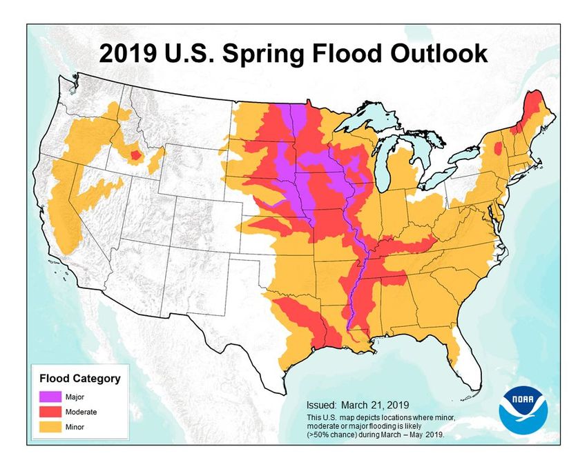
Situation Overview Highlights:
This special USA situation report provides detailed state summaries for storms, tornadoes, straight
line winds and flooding for the past 90 days across the United States.
According to the National Weather Service, there were nearly 4,400 individual reports of severe
weather reported in May alone. These included tornadoes, hail and straight-line winds, and was the
highest recorded since May since 2011. Record-breaking rainfall in Oklahoma and Kansas resulted in
historic flooding throughout the Arkansas River Basin, along with remnant flooding in the Missouri and
Mississippi River. Record rainfall swamped the south-central U.S. over the past few weeks, leading to
catastrophic flooding along the Arkansas River in both Oklahoma and Arkansas. In several locations,
the river was at its highest level ever recorded, including Fort Smith, Ark. basins. source
Twitter handles Facebook pages
@Humanityroad Humanity Road
@DisasterAnimals Animals in Disaster
@jAIDdog
@DAFNReady
About Humanity Road: Founded in 2010 as a 501(c)3 non-profit corporation, Humanity Road is a
leader in the field of online disaster response. Through skilled and self-directed work teams,
Humanity Road and its network of global volunteers aim to provide the public and disaster
responders worldwide with timely and accurate aid information. Providing such information helps
individuals survive, sustain, and reunite with loved ones. For more information, please visit
www.humanityroad.org.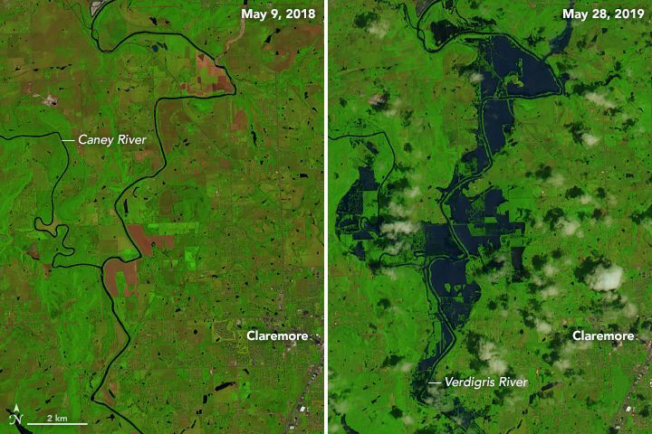
Table of Contents
Situation Overview 3
Significant Updates (most recent first) 4
National Links 4
USA States Impacted 5
Alabama 12 of 67 counties 5
Arkansas - 16 of 75 Counties 7
California - 28 of 58 Counties and 3 Indian Reservations 9
Colorado 0 counties of 64 counties 10
Florida - 4 of 67 Counties 11
Georgia - 6 Counties of 159 Counties 11
Illinois- 34 Counties of 102 12
Indiana - 8 Counties of 92 14
Iowa - 75 of 99 Counties and 1 Tribe 14
Kansas - 63 of 105 Counties 17
Kentucky- 57 of 120 Counties 19
Louisiana- 10 Counties of 64 Counties 21
Mississippi - 22 counties of 82 counties 22
Missouri - 12 Counties of 114 counties 23
Montana- 8 Counties of 56 counties 26
Nebraska - 80 of 93 Counties and 4 Native American 26
New Mexico - 2 Counties of 33 counties 28
North Carolina 5 of 100 counties 29
North Dakota - 2 Counties of 53 counties 29
Ohio - 21 counties of 88 counties 30
Oklahoma - 77 Counties of 77 counties 32
Oregon - 5 Counties of 36 counties 33
Pennsylvania - 6 Counties of 67 counties 34
South Carolina - 0 Counties of 46 counties 35
Tennessee - 57 Counties of 95 counties 36
Texas - 26 Counties of 254 counties 36
Washington - 9 Counties of 39 counties 38
Response and Recovery efforts 39
Special Needs and vulnerable populations 40
Maps and Reports 40
Volunteers Reporting 40
support@humanityroad.org www.humanityroad.org Support our work Page 2 of 42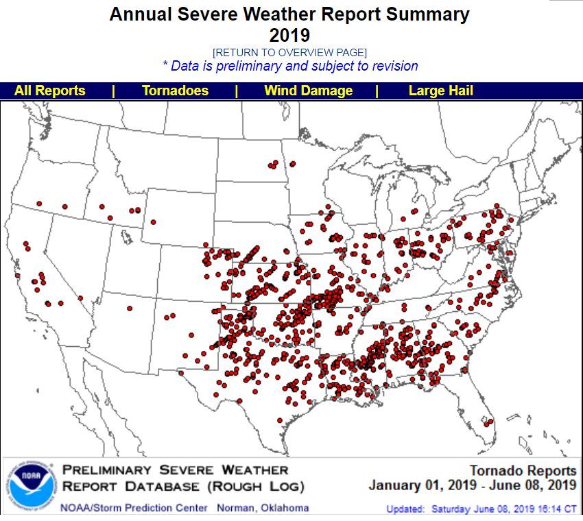
Appendix 41
Situation Overview
The Southern and Central United States have been battered by Tornado outbreaks and drenched by
rainstorm after rainstorm in the spring of 2019, leading to widespread flooding. Across the continental
United States, river gauges at 404 locations were above flood stage on May 29, with the vast majority
along the Missouri, Mississippi, and Arkansas rivers and their tributaries.
The problem was most acute in late May along the Arkansas River. As of May 29, the National
Weather Service reported flooding at 22 gauges along the river in Kansas, Oklahoma, and Arkansas,
not including nearby tributaries and lakes. Major flooding was observed at 13 of those gauges. News
media and forecasters predicted flooding in every major community along the river in the coming
days. Every county in Oklahoma was in a state of emergency, and evacuations were ordered or
recommended in several communities in Arkansas. source The image pair below shows flooding on
the northeast side of Tulsa, along the Caney and Verdigris rivers, which flow into the Arkansas.
support@humanityroad.org www.humanityroad.org Support our work Page 3 of 42
Significant Updates (most recent first)
● In the past 90 days 27 states and 650 counties and parishes have been impacted by
significant weather events including tornadoes, straight line winds, hail and flooding.
● Receding flood waters are revealing damage to roads and bridges source
● California, the La Jolla band of Luiseno, Cahuilla band of Indians, and Soboba Indian
reservation have all experienced flooding, landslides and mudslides FEMA DR 4425.
● Oklahoma: The Muskogee and Cherokee Nations closed riverfront casinos. source
● Oklahoma: Cherokee Nation Tribal responding to flood damage from the Arkansas River at the
local public schools and the tribal head start building. source
● In the following report, tornado items appearing in red are EF 2 or higher.
National Links
FEMA
● Website https://www.fema.gov/
● Twitter https://twitter.com/fema
● Facebook https://www.facebook.com/FEMA/
National Weather Service (NWS)
● Website https://www.weather.gov/
● Twitter https://twitter.com/nws
● Facebook https://www.facebook.com/nws
American Red Cross
● Website http://www.redcross.org/
● Twitter http://www.twitter.com/redcross
● Facebook https://www.facebook.com/redcross
Distress Line
● Website https://www.samhsa.gov/find-help/disaster-distress-helpline
● Twitter https://twitter.com/distressline
● Facebook https://www.facebook.com/samhsa
Humanity Road
● Website: https://humanityroad.org
● Twitter: https://twitter.com/humanityroad
● Facebook https://www.facebook.com/humanityroad
ITDRC
● Website https://itdrc.org
support@humanityroad.org www.humanityroad.org Support our work Page 4 of 42● Twitter: https://twitter.com/itdrc
● Facebook https://www.facebook.com/itdrc
USA Childcare Aware
● Website usa.childcareaware.org
● Twitter https://twitter.com/childcareaware
● Facebook https://www.facebook.com/ChildCareAware/
Crisis Cleanup
● Website https://t.co/XPj8kzCKGR
● Twitter https://twitter.com/CrisisCleanup
● Facebook https://www.facebook.com/CrisisCleanup/
USA States Impacted
Alabama 12 of 67 counties
Social Media Accounts
Twitter: https://twitter.com/AlabamaEMA
Facebook: http://www.facebook.com/AlabamaEMA
Website: http://ema.alabama.gov/
General Summary
As of June 6, a total of 13 counties in Alabama were declared a disaster from recent severe storms,
straight line winds, tornadoes and flooding ( Blount, Cherokee, Colbert, DeKalb, Franklin,
Greene, Jackson, Lee, Lamar, Madison, Marion, Morgan, Winston). For year to date 2019
NOAA reports 1 a total of 351 Severe Weather reports for Alabama including 75 Tornadoes, 35 Hail
reports and 241 Wind Reports. In the past 90 days, there have been 47 tornadoes impacting
communities across 32 counties.
Tornado Summary
Alabama on average has 47 tornadoes each year. As of April 22, 2019 a total of 54 tornadoes had
already been reported source. An EF4 tornado struck Beauregard, Alabama on March 3 killing 23
people and leaving thousands without power. The tornado was nearly a mile wide in Lee County
source. On March 5, a presidential major disaster declaration was made following severe storms,
straight-line winds, and tornadoes that impacted Lee County on March 3rd. source.
Below is a summary of tornado and storm related disaster declarations in past 90 days for Alabama.
Mar 3
● Tornado Outbreak
County EF Location
○ Macon-Lee EF4 Beauregard - NW of Society Hill & NE of Smiths Station
○ Barbour EF2 Weedon Field NE of Old Town Creek Recreation Area
1
https://www.spc.noaa.gov/climo/online/monthly/states.php?month=00&year=2019&state=AL
support@humanityroad.org www.humanityroad.org Support our work Page 5 of 42○ Barbour EF2 County Rd 79 SSW of Batesville & SW Lugo
○ Macon-Lee EF2 Davisville ESE of Liverpool & S of Griffen Mill
○ Geneva EF1 NNE of Fadetter & S of Slocomb
○ Washington EF1 SW of Mcintosh
○ Washington EF1 S of Chatom
○ Crenshaw-Pike EF1 NW of Honoraville
○ Henry EF0 SE of Shorterville
○ Bullock EF0 County Rd 8 SSW of Inverness SW Lugo
○ Autauga EF0 County Rd 33 ENE of Mulberry
Mar 4
● Severe Storms, Straight-line Winds, And Tornadoes
○ FEMA DR-4419 Declared on Monday, March 4, 2019 - 19:00
○ Map: https://gis.fema.gov/maps/dec_4419.pdf
○ Counties: Lee County
Mar 14
● Tornado Outbreak
County EF Location
○ Elmore EF2 WNW of Holtville & NE of Ten Cedars Estates
○ Autauga EF1 S of Dawson Mill & SSW of Vida Junction
○ Cullman EF1 NNW of Hanceville & NNw of Holly Pond
○ Perry-Chilton EF1 ESE Ellards & NE of Oakmulgee
○ St. Clair EF1 SE St Clair Springs & N of Wattsville
○ Blount-Etowah-StClair EF1 SW Allgood to N of Camp Sumatanga
○ Chilton-Coosa EF0 NNW of Gap of the Mtn & SSE of Marble Valley
○ Perry-Douglass EF0 NNW & NNE of Central Mills
○ Marengo EF0 ENE of Dayton & SW of Uniontown
○ Calhoun EF0 N of Ohatchee
○ Perry EF0 ENE of Morgan Springs & Heiberger
○ Tuscaloosa EF0 S of Bankhead Lock & Dam & WSW Bull City
○ Blount EF0 NW of Allgood & W of Oneonta
○ Randolph EF0 SSW of Wedowee & SSW Woodland
○ Coosa EF0 ESE of Parkdale & N of Goodwater
Apr 8
● Tornado Outbreak
County EF Location
○ Blount EF1 ESE of Blountsville & SSW of Brooksville
○ Blount EF0 SW Hayden & NE Hayden
Apr 13
● Tornado Outbreak
County EF Location
○ Franklin EF1 ENE of Red Bay & NNE of Red Bay
○ Marion EF1 SSW of Shottsville & WSW Shottsville
○ Marshall EF1 NNW of Douglas and S of Guntersville
Apr 14
● Tornado Outbreak
County EF Location
○ Colbert EF1 WSW of Leighton
○ Etowah EF1 NNE of Glencoe - NNE Hokes Bluff
support@humanityroad.org www.humanityroad.org Support our work Page 6 of 42○ Tuscaloosa EF1 NE of Low Gap and N of Hagler
○ Pike EF1 WSW of Troy
○ Crenshaw-Pike EF0 W of Goshen
○ Pike EF0 W of Henderson
○ Russell EF0 SE of Phenix City
○ Shelby EF0 WNW of Calera - SSE of Shelby Cty Airport
○ Shelby EF0 SE of Oak Mountain Lake & W of Shoal Creek Golf Club
○ Perry EF0 ENE of Sprott & SW Oakmulgee
○ Hale EF0 NE of Gallion & E of Cedarville
Apr 16
● Severe Storms, Straight-line Winds, Tornadoes, And Flooding
○ FEMA DR-4426 Declared on Tuesday, April 16, 2019 - 20:00
○ Map: https://gis.fema.gov/maps/dec_4426.pdf
○ Counties: Blount, Cherokee, Colbert, DeKalb, Franklin, Greene, Jackson,
Lamar, Madison, Marion, Morgan, Winston
May 8
● Tornado Outbreak
County EF Location
○ DeKalb EF1 SSE of Fyffe
○ Marshall EF1 NE of Albertville
○ Madison EF0 N of Hazel Green
May 12
● Tornado Outbreak
County EF Location
○ Houston EF0 Dothan
Arkansas - 16 of 75 Counties
Social Media Accounts
Twitter: https://twitter.com/AR_Emergencies
Facebook: http://www.facebook.com/Aremergencies
Website: https://www.adem.arkansas.gov/
General Summary
As of June 7, severe storms and flooding have impacted 16 counties: Arkansas, Conway, Crawford,
Desha, Faulkner, Franklin, Jefferson, Johnson, Lincoln, Logan, Perry, Pope, Pulaski, Sebastian,
Washington, and Yell
On May 28, the Arkansas River in western Arkansas was at its highest water level ever recorded.
source Near the Oklahoma border at Fort Smith, Arkansas (pop 300,000), the river rose to two feet
above its previous all-time high on Tuesday morning, and was predicted to rise at least another two
feet before cresting on Wednesday. As of May 31, Along the Arkansas River in Arkansas,
support@humanityroad.org www.humanityroad.org Support our work Page 7 of 42communities prepared for more record-breaking crests. Officials ordered mandatory evacuations for
about 500 homes that sit within the levee system in Jefferson County, just southwest of Little Rock.
source Arkansas Department of Health is waiving the $17 fee for flood victims to have private wells
tested for bacterial contamination. A water sampling kit is available for free at each of the state's 75
local county health units
By June 6 flooding was finally receding in most parts of Central Arkansas along the Arkansas River,
but at Lake Conway, flooding is still a major problem for many residents. Arkansas Game and Fish
Commission explains that floodwater from the Arkansas River is flowing backward through Palarm
Creek, filling Lake Conway. source
Tornado Summary
For 2019 NOAA reports 2 a total of 197 severe weather events including 24 Tornadoes, 34 Hail and
139 Wind reports.
Mar 9
● Tornado Outbreak
County EF Location
○ Pulaski / Lonoke EF1 E of Wrightsville NNW of Keo
○ Lonoke / Prairie EF1 S of Culler S of Screeton
○ Lonoke / Prairie EF1 S of Parkers Corner WNW of Slovak
Apr 30
● Tornado Outbreak
County EF Location
○ Boone EF1 SSE of Berman WSW South Lead Hill
May 2
● Tornado Outbreak
County EF Location
○ Pulaski EF0 NNW of Sylvan Hills, SSW of Olmstead
○ Faulkner EF0 SW of Otto NNE of Cato
○ Prairie EF0 WSW of Des Arc to NNW of Des Arc
○ Jacson EF0 ese OF sWIFTON
○ Greene EF0 NE of Lafe
May 8
● Tornado Outbreak
County EF Location
○ Jefferson EF0 ENE of Pine Bluff
May 18
● Tornado Outbreak
County EF Location
○ Le Flore / Sebastian EF1 SSW of Arkoma to NE of Ft Smith
○ Sebastian EF1 NW of Greenwood to NE of Greenwood
○ Sebastian / Crawford EF1 NW of Barling to SW of Kibler
○ Sebastian / Franklin EF1 SE of Lavaca to NNE of Charleston
2
https://www.spc.noaa.gov/climo/online/monthly/states.php?month=00&year=2019&state=AR
support@humanityroad.org www.humanityroad.org Support our work Page 8 of 42○ Crawford EF1 NW of Mulberry to ENE of Mulberry
○ Prairie EF0 W of Slovak
May 21
● Arkansas Severe Storms And Flooding (EM-3414)
○ FEMA EM-3414 Declared on Wednesday, May 29, 2019 - 20:00
○ Counties: Arkansas, Chicot, Conway, Crawford, Desha, Faulkner, Franklin,
Jefferson, Johnson, Lincoln, Logan, Perry, Pope, Pulaski, Sebastian, Yell
California - 28 of 58 Counties and 3 Indian Reservations
Social Media Accounts
Twitter: https://twitter.com/Cal_OES
Facebook: https://www.facebook.com/CaliforniaOES
Website https://www.caloes.ca.gov/
General Summary:
A presidential disaster declaration was made for the La Jolla Indian Reservation on March 26, for the
Cahuilla Indian Reservation on March 27, and for the Soboba Band Luiseno Indians on April 9, 2019
due to the impact of severe storms, flooding and landslides in February. Public Assistance was
approved. (Assistance to State, Local, Tribal and Territorial governments and certain
private-non-profit organizations for emergency work and the repair or replacement of
disaster-damaged facilities). In addition, All areas within the La Jolla Band of Luiseño
Indians, the Cahuilla Indian Reservation, and the Soboba Band Luiseno Indians are eligible
for assistance under the Hazard Mitigation Grant Program.
In May, an additional 28 counties were declared a disaster due to winter storms, flooding,
mudslides and landslides. In 2019 NOAA reports 3 35 severe weather reports including 14
tornadoes, 8 hail and 13 wind reports.
Feb 2
County EF Location
Colusa EF0 2 m E of Stegeman
Mariposa EF0 2 m NNW of Ben Hur
Sutter EF0 5 m SSW Yuba City S
Feb 15
● Tornado Outbreak:
County EF Location
Madera EF0 5 m SE of Knowles
Mar 26
● La Jolla Band of Luiseño Indians Severe Storms, Flooding, Landslides, And Mudslides
3
https://www.spc.noaa.gov/climo/online/monthly/states.php?month=00&year=2019&state=CA
support@humanityroad.org www.humanityroad.org Support our work Page 9 of 42○ FEMA DR-4422 Declared on Tuesday, March 26, 2019 - 20:00
○ Map: Mar 26 La Jolla Band Disaster Declaration Storms, mudslides, landslides
○ Counties: L a Jolla Indian Reservation
Mar 28
● Cahuilla Band of Indians Severe Storms And Flooding (DR-4423)
○ FEMA DR-4423 Declared on Wednesday, March 27, 2019 - 20:00
○ Map: Mar 27 Cahuilla Indian Reservation Disaster Declaration
○ Counties: Cahuilla Indian Reservation
Apr 8
● Soboba Band Luiseno Indians Severe Storms And Flooding (DR-4425)
○ FEMA DR 4425 Major Disaster Declaration declared on April 08, 2019
○ Map: Map Soboba Band Luiseno Indians Severe Storms And Flooding
(DR-4425)
○ Counties: Soboba Indian Reservation
May 1
● California Severe Winter Storms, Flooding, Landslides, And Mudslides
○ FEMA DR-4431 Declared on Tuesday, April 30, 2019 - 20:00
○ Map: Map California Severe Winter Storms, Flooding, Landslides, And Mudslides
○ Counties: Calaveras, Colusa, Marin, Mariposa, Mendocino, Modoc, Napa,
Riverside, Santa Barbara, Shasta, Trinity
May 17
● California Severe Winter Storms, Flooding, Landslides, And Mudslides
○ FEMA DR-4434 May 17 California Severe Winter Storms, Flooding, Landslides,
Map: https://gis.fema.gov/maps/dec_4434.pdf
○ Counties: Amador, Butte, Colusa, Del Norte, El Dorado, Glenn, Humboldt,
Lake, Marin, Mariposa, Mendocino, Monterey, Napa, Sonoma, Tehama,
Trinity, Tuolumne
Colorado 0 counties of 64 counties
Social Media
Twitter: https://twitter.com/COEmergency
Facebook: https://www.facebook.com/COEmergency
Website: http://www.coemergency.com/
General Summary
As of June 7, 2019 there have been no disaster declarations for the state of Colorado. For year to
date 2019 NOAA reports4 113 severe weather reports including 26 tornadoes, 64 hail reports and 23
wind reports. Currently Avalanche debris causing blockages leading to potential flood threats.
Updates can be accessed at http://www.coemergency.com/
4
https://www.spc.noaa.gov/climo/online/monthly/states.php?month=00&year=2019&state=CO
support@humanityroad.org www.humanityroad.org Support our work Page 10 of 42Tornado Summary: In May, tornadoes were reported in several Colorado counties including Weld,
Adams, Lincoln, Kiowa, Prowers and Bent. Most of the twisters were on the ground for five minutes or
less and none of them caused any damage
Florida - 4 of 67 Counties
Social Media
Twitter: https://twitter.com/FLSERT
Facebook: http://www.facebook.com/FloridaSERT
Website: http://www.floridadisaster.org/
General Summary
In 2019 year to date, NOAA reports that Florida experienced a total of 265 severe weather events, 14
Tornado reports, 38 Hail reports and 225 wind reports. No significant flooding however, current and
recent thunderstorms this week brought heavy rainfall and led to flooded roadways across South
Florida, leaving thousands of people without power. Currently no streams are in flood stage.
USGS Flood Map
Tornado Summary
May 3 Tornado outbreak Florida Map The strongest tornado was rated EF-3 in Leon/Jefferson
County, Florida. This was only the second F3 or EF-3 to affect Leon County since 1945. In Jackson
County 16 homes were damaged by an EF1.
Mar 3
● Tornado Outbreak:
County EF Location
Leon & Jefferson County EF3 Leon County
Jackson County EF1 Jackson County
Walton County EF0 Walton County
Gadsden County EF1 Gadsden County
Georgia - 6 Counties of 159 Counties
Social Media
Twitter: https://twitter.com/GeorgiaEMA
Facebook: http://www.facebook.com/GEMA
Website: http://georgia.gov/agencies/georgia-emergency-management-agency
General Summary:
support@humanityroad.org www.humanityroad.org Support our work Page 11 of 42For year to date 2019 NOAA reports 5 352 severe weather events including 53 tornadoes, 38 hail
reports and 261 wind reports. More than 460 people are still staying in 26 Red Cross and community
shelters and that number could rise as new storms threaten and flood waters continue to overflow the
river banks. source
Flooding Summary: On April 19th, 2019 a very heavy rainfall lead to flash flooding in several areas
some received 6 inches of rain. source In May the downtown area of Helen, Georgia flooded due to
the Chattahoochee river with business damage and road damage. source. Flooding Map
Tornado Summary
Mar 3
● Tornado Outbreak:
County EF Location
○ Crawford EF2 Greer Rd, Wesley Chapel Rd
○ Stewart EF2 Wesley Chapel Rd & Philadelphia Rd
○ Webster EF2 Wester
○ Columbia EF2 Evans
○ Harris EF2 along Gray Rock Rd & Ellerslie
○ Talbot EF2 Talbotton
○ Harris EF1 Pine Mountain & Hwy GA-18
○ Peach EF1 Taylors Mill Rd, Vinson Rd
○ Muskogee EF1 near Winding Ridge Rd
○ Quitman EF1 Lakepoint Resort State Park
○ Twiggs EF1 Huber near KaMin factory
○ Wilkinson EF1 S of Toomsboro
○ Washington EF1 S of Heards Bridge Rd
○ Washington EF1 Oconee, Kaolin Rd & Hwy 272
○ Bibb EF0 Macon
○ Telfair EF0 E of Workmore, Big Horse Creek Rd
○ Telfair EF0 Workmore S of McRae
○ Macon / Peach EF0 E of Marshallville
○ Taylor EF0 S of Ruper
Illinois- 34 Counties of 102
Social Media
Twitter: https://twitter.com/ReadyIllinois
Facebook: http://www.facebook.com/ReadyIllinois
Website: http://iema.illinois.gov/iema/index.asp
General Summary:
On May 3, 2019, after major flooding, the governor issued a state disaster declaration for 34 of the
102 counties in Illinois. Illinois has seen record river crests, residential evacuations and flood-related
washouts and road buckling. As of May 31, About 200 Illinois National Guard members had been
5
https://www.spc.noaa.gov/climo/online/monthly/states.php?month=00&year=2019&state=GA
support@humanityroad.org www.humanityroad.org Support our work Page 12 of 42deployed along the Illinois and Mississippi rivers to assist with flood and levee monitoring. flooding in
the state has been ongoing for about 80 days and is expected to reach “historic highs.” It comes amid
spring flooding across the Midwest . John Sullivan of the Illinois Department of Agriculture says just
35% of corn crops and 14% of soybeans had been planted this season because of heavy rainfall
source
Tornado Summary:
For year to date 2019 NOAA reports 6 a total of 294 severe weather events including 21 tornadoes,
61 hail reports and 212 wind reports. While there were 21 tornadoes in the past 90 days in Illinois,
none were rated higher than EF1. There are no disaster declarations related to tornadoes in Illinois.
May 3
● Severe Flooding and Storms
○ Governor declares 34 counties battling floods disaster areas source
○ Map: USGS Illinois Flood Map
○ Counties: Adams, Alexander, Brown, Bureau, Calhoun, Carroll, Cass, Fulton,
Greene, Grundy, Hancock, Henderson, Jackson, Jersey, Jo Daviess, LaSalle,
Madison, Marshall, Mason, Mercer, Monroe, Morgan, Peoria, Pike, Putnam,
Randolph, Rock Island, Schuyler, Scott, St. Clair, Tazewell, Union, Whiteside,
Woodford
May 23
● Tornado Outbreak
County EF Location
○ Sangamon, Menard, Logan EF1 SW of Cantrall to W of Broadwell
○ Logan EF1 N of Lincoln
○ Piatt EF1 N of Cisco
○ Vermilion EF1 Muncie
○ Clay EF0 WSW of Xenia
May 24
● Tornado Outbreak
County EF Location
○ McDonough EF1 N of Industry
○ McDonough EF1 NE of Industry
○ Champaign EF1 Champaign
○ Champaign EF1 Urbana
○ Champaign EF1 SW of St Joseph
○ Fulton EF0 W of Lewistown
May 27
● Tornado Outbreak
County EF Location
○ Kendall EF0 NNW of Plattville
○ Will EF0 SW of Romeoville
○ Knox EF0 S of Dahinda
○ Vermillion EF0 S of Henning
6
https://www.spc.noaa.gov/climo/online/monthly/states.php?month=00&year=2019&state=IN
support@humanityroad.org www.humanityroad.org Support our work Page 13 of 42○ Lee EF0 SW of Paw Paw
○ Cook EF0 SSE of Sauk Village
○ Woodford EF0 NW of Benson
May 29
● Tornado Outbreak
County EF Location
○ Christian EF0 NNW of Stonington
○ Christian EF0 N of Edinburg
○ Christian EF0 NE of Stonington
○ Macon EF0 E of Blue Mound
Indiana - 8 Counties of 92
Twitter: https://twitter.com/IDHS
Facebook: http://www.facebook.com/pages/Indiana-Department-of-Homeland-Security/22183791246
Website: http://www.in.gov/sema/
General Summary
For year to date 2019 NOAA reports 7 294 severe weather events including 21 tornadoes, 61 hail
reports and 212 wind reports. As of June 10, 2019 there have been no disaster declarations for the
state of Indiana.
Tornado Summary
There were at least 500 structures damaged in the Pendleton area when an EF-2 tornado swept
across Madison County on Memorial Day. According to preliminary damage estimates roughly 1,500
structures in the storm's path were surveyed and about 33 percent of those structures suffered some
level of damage. At least 30 to 40 of those structures were either destroyed or heavily damaged
May 27
● Tornado Outbreak
County EF Location
○ Miami, Fulton EF3 N of Macy to SSE of Silver Lake
○ Blackford, Wells EF3 N of Roll to S of Nottingham
○ Madison EF2 Pendleton
○ Grant EF2 SSW of Somerset
○ Wabash EF1 NW of Manchester
○ Henry EF1 S of Middletown
○ Henry EF1 ESE of Middletown
Iowa - 75 of 99 Counties and 1 Tribe
7
https://www.spc.noaa.gov/climo/online/monthly/states.php?month=00&year=2019&state=IN
support@humanityroad.org www.humanityroad.org Support our work Page 14 of 42Social Media
Twitter: https://twitter.com/IowaHSEMD
Facebook: https://www.facebook.com/IowaHSEMD
Website: https://www.homelandsecurity.iowa.gov/
General Summary:
As of June 7, 2019, Iowa state disaster proclamations were made for 75 of the 99 counties in Iowa.
Ten streams are in flood stage as of June 10, 2019 Map
Presidential declarations were made for 58 counties and 1 tribe as a result of severe storms and
flooding. Counties: Adair, Adams, Allamakee, Appanoose, Audubon, Boone, Bremer, Buena Vista,
Butler, Calhoun, Carroll, Cass, Cedar, Cherokee, Clay, Clinton, Crawford, Dallas, Davis, Decatur,
Des Moines, Dickinson, Emmet, Fayette, Franklin, Fremont, Greene, Guthrie, Hamilton, Hancock,
Hardin, Harrison, Henry, Howard, Humboldt, Ida, Iowa, Iowa, Jasper, Johnson, Kossuth, Lee, Louisa,
Lucas, Lyon, Madison, Mahaska, Marion, Marshall, Mills, Monona, Monroe, Montgomery, O'Brien,
Osceola, Page, Palo Alto, Plymouth, Pocahontas, Polk, Pottawattamie, Pottawattamie, Sac, Scott,
Shelby, Sioux, Tama, Union, Van Buren, Wapello, Wayne, Webster, Winnebago, Winneshiek,
Woodbury, Wright, source
Since March 2019 Iowa has been in flood stage due to rain, melting snow, and ice jams. Iowa was
declared a state of emergency by March 16th, 2019 for the following counties; Fremont, Harrison,
Louisa, Mills, Monona, Pottawattamie, Scott, Shelby, Woodbury. Missouri Valley evacuated 2,000
residents. Primghar, Iowa had record rainfall levels at 50.8 mm in 24 hours. Currently there are 20
stream gauges flooding. source
Tornado Summary:
For year to date 2019 NOAA reports 8 112 severe weather reports including 27 tornadoes, 37 hail
reports and 48 wind reports. 56 counties Multiple tornadoes ripped through eastern Iowa in May
damaging several homes, barns and trees. source
Mar 12
● Severe Storms And Flooding
○ FEMA DR-4421 Declared on Friday, March 22, 2019 - 20:00 FEMA DR-4430
Declared on Sunday, April 28, 2019 - 20:00
○ Map: May 10 2019 Severe Storms and Flooding PDF
○ Public Assistance Counties: Adair, Adams, Allamakee, Audubon, Boone,
Bremer, Buena Vista, Butler, Calhoun, Carroll, Cass, Cherokee, Clay,
Crawford, Dallas, Decatur, Dickinson, Emmet, Fayette, Franklin, Fremont,
Greene, Guthrie, Hamilton, Hancock, Hardin, Harrison, Howard, Humboldt,
Ida, Iowa, Jasper, Kossuth, Lyon, Madison, Mahaska, Marshall, Mills,
Monona, Montgomery, O'Brien, Osceola, Page, Palo Alto, Plymouth,
Pocahontas, Polk, Pottawattamie, Sac, Shelby, Sioux, Tama, Union,
Webster, Winnebago, Winneshiek, Woodbury, Wright
○ Individual Assistance Counties: Fremont, Harrison, Louisa, Mills,
Monona, Pottawattamie, Scott, Shelby, and Woodbury.
8
https://www.spc.noaa.gov/climo/online/monthly/states.php?month=00&year=2019&state=IA
support@humanityroad.org www.humanityroad.org Support our work Page 15 of 42Mar 13
● Sac and Fox Tribe of the Mississippi in Iowa Severe Storms And Flooding
○ FEMA DR-4430
○ Map : Mar 13 Sac and Fox Tribe Severe Storms and Flooding
○ Counties: Sac and Fox Tribe of the Mississippi in Iowa
May 22
● Tornado Outbreak
County EF Location
○ Adair, Guthrie EF2 Adair
○ Cass EF1 SE of Anita
May 24
● Tornado Outbreak
County EF Location
○ Johnson EF1 Iowa City
○ Cedar EF0 NE of West Branch
May 27
● Tornado Outbreak
County EF Location
○ Van Buren EF3 ENE of Cantril
○ Floyd EF1 Charles City
○ Howard EF1 S of Saratoga to Lime Springs
○ Lee EF1 Houghton
○ Howard EF0 SW of Elma
○ Des Moines EF0 SW of Burlington
May 27
● Tornado Outbreak
County EF Location
○ Poweshiek EF1 NNE of Barnes City
○ Humboldt EF0 SE of Bradgate
○ Iowa EF0 SE of Victor
○ Poweshiek EF0 NE of Deep River
○ Hardin EF0 ESE of Garden City
○ Poweshiek EF0 SE of Guernsey
○ Iowa EF0 E of Guernsey
○ Johnson EF0 NW of Kalnone
○ Hardin EF0 E of New Providence
○ Hardin EF0 SW of Eldora
○ Hardin EF0 WNW of Owasa
○ Hardin EF0 E of Steamboat Rock
June 4
● Gov. Kim Reynolds issued a disaster proclamation May 29 for 10 counties in
response to heavy rains, hail, straight-line winds, tornadoes, widespread flooding,
and flash flooding beginning May 17 and continuing. She also issued proclamations
on May 30 for Van Buren County, May 31 for Appanoose, Cedar, Davis, Johnson,
support@humanityroad.org www.humanityroad.org Support our work Page 16 of 42Lucas, Monroe, and Pottawattamie counties, and on June 4 for Union County for
severe weather beginning May 17.
● Counties: Appanoose, Cedar, Clinton, Davis, Des Moines, Henry, Iowa, Johnson,
Lee, Louisa, Lucas, Marion, Monroe, Pottawattamie, Scott, Van Buren, Union,
Wapello, Wayne
Kansas - 63 of 105 Counties
Social Media
Twitter: https://twitter.com/KansasEmergency
Facebook: https://www.facebook.com/KansasEmergency/
Website: http://www.kansastag.gov/kdem_default.asp
General Summary:
On June 4, 2019 Atchison, Bourbon and Ford Counties were added to the state disaster proclamation
signed by Governor Laura Kelly May 9 which brings the total to 63 of the 105 counties in Kansas.
Counties currently named in the declaration are: Allen, Anderson, Barber, Barton, Butler, Chase,
Chautauqua, Cherokee, Clark, Clay, Cloud, Coffey, Comanche, Cowley, Crawford, Dickinson,
Doniphan, Douglas, Edwards, Elk, Ellsworth, Franklin, Geary, Gray, Greenwood, Harper, Harvey,
Hodgeman, Jefferson, Kingman, Leavenworth, Lincoln, Linn, Lyon, Marion, Marshall, McPherson,
Meade, Montgomery, Morris, Nemaha, Neosho, Norton, Osage, Ottawa, Pawnee, Phillips,
Pottawatomie, Pratt, Reno, Rice, Riley, Rush, Russell, Saline, Sumner, Wabaunsee, Washington,
Wilson, and Woodson. source
Lakeside Village in Jefferson County is without water supply as a result of flooding. The Kansas
National Guard, in partnership with Fort Riley’s 1st Infantry Division and the Nebraska National
Guard, will be transporting six HIPPOs (Load Handling System Compatible Water Tank Racks) to the
community to fill their pump house to supply their water system. A liaison officer has also been sent
to the area to coordinate with local officials.
All American Red Cross shelters are currently closed. Ten shelters are on standby. All pet shelters
have been closed with four on standby. The Kansas State Animal Response Team is supporting pet
shelter needs, as needed.
On May 28, a presidential emergency declaration was made for 33 counties for public assistance.
Flood Map
Tornado Summary:
For year to date 2019, NOAA reports 9 a total of 645 severe weather reports including 97 tornadoes,
287 hail and 261 wind reports.
9
https://www.spc.noaa.gov/climo/online/monthly/states.php?month=00&year=2019&state=KS
support@humanityroad.org www.humanityroad.org Support our work Page 17 of 42On May 17, 2019 an EF3 long-tracked tornado passed near the towns of Minneola and Bloom,
significantly damaging multiple farmsteads. A semi-truck was blown off the road near the beginning of
the path. Homes sustained major structural damage, including roof and exterior wall loss. Barns and
outbuildings were completely destroyed, including a metal-framed structure that was severely
mangled. Farm machinery was thrown and damaged, trees were snapped and denuded, and a
wooden projectile was speared into a dirt road. source
On May 28, 2019 an EF4 tornado touched down south of Lawrence about 6:15 pm and continued
northeast for more than 31 miles before lifting in Leavenworth County. Douglas County officials said
the storm injured 17 people, three of them seriously, and damaged more than 60 homes. source The
tornado developed in southwestern Douglas county Kansas and tracked to the east-northeast while
strengthening. EF-3 damage occurred in northeastern Douglas county, then the storm gained
strength and produced EF-4 damage in southern Leavenworth county Kansas.
May 17
● Tornado Outbreak
County EF Location
○ Meade, Clark, Ford EF3 SE of Fowler to W of Ford
○ Ford, Edwards EF2 Ford, Edwards
○ Edwards EF2 Lewis to N of Belpre
May 20
● Tornado Outbreak
County EF Location
○ Cherokee EF1 S of Chicopee
○ Crawford EF1 S of Pittsburg
May 21
● Tornado Outbreak
County EF Location
○ Nemaha EF3 Bern
○ Jackson EF2 SW of Mayettato S of Whiting
○ Dickinson EF1 SSE of Enterprise to S of Chapman
○ Nemaha EF1 SW of Oneida
○ Atchison EF1 NW of Effingham
○ Dickinson, Geary EF0 E of Chapmanto ENE of Milford
○ Shawnee, Jackson EF0 E of Rossvilleto SW of Mayetta
May 22
● Tornado Outbreak
County EF Location
○ Cherokee EF1 Treece
May 24
● Tornado Outbreak
County EF Location
○ Marshall EF1 Marysville
○ Nemaha EF1 N of Seneca
○ Butler EF0 Douglass
support@humanityroad.org www.humanityroad.org Support our work Page 18 of 42May 24
● Tornado Outbreak
County EF Location
○ Kansas EF1 NE of Cimarron
○ Ford EF1 N of Ford
○ Hodgeman EF1 NE of Hanston
○ Thomas EF1 W of MIngo
May 27 (May 9 and Continuing)
● Tornadoes And Flooding
○ FEMA EM-3412 Declared on Monday, May 28, 2019 - 20:00
○ Map: https://waterwatch.usgs.gov/new/index.php?r=ks&id=ww_flood
○ Public Assistance Counties: Allen, Anderson, Butler, Chautauqua,
Cherokee, Coffey, Cowley, Crawford, Dickinson, Doniphan, Douglas, Elk,
Franklin, Geary, Greenwood, Harvey, Jefferson, Leavenworth, Linn, Lyon,
Marshall, Montgomery, Morris, Neosho, Osage, Pottawatomie, Reno,
Riley, Saline, Sumner, Wabaunsee, Wilson, Woodson
May 28
● Tornado Outbreak
County EF Location
○ Douglas, Leavenworth EF4 ENE of Overbrook to Linwood, Bonner Springs
○ Russell, Osborne, Jewell, Mitchell EF2 W of Waldoto S of Tipton
Kentucky- 57 of 120 Counties
Social Media
Twitter: https://twitter.com/KentuckyEM
Facebook: https://www.facebook.com/KentuckyEM/
Website: https://kyem.ky.gov/Pages/default.aspx
General Summary:
As of June 7, 2019 there are 57 of the 120 counties in Kentucky that have received a Presidential
disaster declaration.
In early April, Gov. Matt Bevin sent a letter requesting a Presidential Disaster Declaration for 58
Kentucky counties that were impacted during a severe weather event in February and March. The
system produced extended episodes of strong winds and torrential rain which caused flooding, flash
flooding, landslides, and mudslides. The weather system caused over $41 million in damages
statewide, the majority of that related to highways, bridges, and utility infrastructure. Three
Kentuckians lost their lives during this event, along with many minor injuries.
support@humanityroad.org www.humanityroad.org Support our work Page 19 of 42Severe storms in February increased water levels at dams in central and western Kentucky, resulting
in record water releases at Wolf Creek Dam in Jamestown that have caused flooding. The Kentucky
Division of Emergency Management has received state of emergency declarations from 36 counties
and 11 cities. Flood Map
Tornado Summary
For year to date 2019 NOAA Reports 10 164 severe weather events including 13 tornadoes, 25 hail
reports and 126 wind reports.
On March 14, 2019, Scattered supercell thunderstorms developed ahead of a cold front on the 14th
as it swept east across our region during the day. The supercell activity was preceded by widespread
rain and thunderstorms the previous night. The overnight rain was locally heavy, causing some
flooding in western Kentucky. Throughout the event, strong gradient winds associated with a strong
low pressure system gusted up to 50 mph at times and 6 tornadoes were reported.
An EF2 tornado impacted the counties of McCracken, Ballard, and Carlisle. The tornado developed
near Cunningham and quickly intensified and widened, reaching 300 yards wide just west of
Lovelaceville. The tornado reached its maximum intensity of EF-2 intermittently from just north of
Lovelaceville to just southeast of Barkley Regional Airport (west of Paducah). At least a dozen homes
sustained major structural damage, including walls blown outward and partial roof loss. Four cows
were killed near Lovelaceville. Dozens of barns, outbuildings, garages, and grain bins were
destroyed. Dozens of homes sustained minor damage, such as loss of shingles. A mall on the west
side of Paducah sustained some roof damage, as well as an adjacent strip mall. Extensive tree and
power line damage caused power outages for thousands. The only reported injury occurred when a
grain bin was blown onto a pickup truck on U.S. Highway 62. source
March 14
● Tornado Outbreak
County EF Location
McCracken, Ballard, Carlysle EF2 Cunningham to Lovelaceville
Union EF1 Morganfield
Henderson EF0 Smith Mills
Henderson, Webster EF0 Sabree
Webster EF0 Slaughters
Graves EF0 Hickory
April 17
● Severe Storms, Straight-line Winds, Flooding, Landslides, And Mudslides
○ FEMA DR-4428 Declared on Tuesday, April 16, 2019 - 20:00
○ Map: https://gis.fema.gov/maps/dec_4428.pdf
○ Counties: Adair, Ballard, Bell, Boyd, Breathitt, Butler, Campbell, Carlisle,
Carroll, Carter, Casey, Clay, Crittenden, Cumberland, Edmonson, Elliott, Estill,
Floyd, Grant, Greenup, Hancock, Harlan, Henderson, Henry, Jackson, Johnson,
Knott, Knox, Laurel, Lawrence, Lee, Leslie, Letcher, Livingston, Madison,
Magoffin, Marion, Marshall, Martin, McCracken, McCreary, Metcalfe, Morgan,
10
https://www.spc.noaa.gov/climo/online/monthly/states.php?month=00&year=2019&state=KY
support@humanityroad.org www.humanityroad.org Support our work Page 20 of 42Owsley, Pendleton, Perry, Pike, Powell, Rockcastle, Russell, Trigg, Union,
Washington, Wayne, Webster, Whitley and Wolfe.
Louisiana- 10 Counties of 64 Counties
Social Media
Twitter: https://twitter.com/GOHSEP
Facebook: http://www.facebook.com/gohsep
Website: www.gohsep.la.gov
General Summary:
For year to date 2019, NOAA reports 11 297 severe weather events for Louisiana including 52
tornadoes, 53 hail events and 192 wind reports. State of emergency declared for flooding that began
on May 10, 2019 due to tornadoes with 373 homes damaged and public property and infrastructure.
As of June 10, eight stream gauges are in flood in Louisiana Current Flood Map
Tornado Summary
On June 3, 2019, a federal disaster declaration was made for the parishes of Lincoln, Morehouse,
and Union. The request was made after tornadoes in April hit the area, doing more than $12 million
of damages. Two people were killed. Louisiana Tech University was also affected. source
The Governor of Louisiana declared a state of emergency following the tornado outbreak of April
25-26, 2019 after multiple road closures, power outages, downed trees, debris and structures
damages were reported in Lincoln, Union, Bienville, Caddo, DeSoto, LaSalle, and Morehouse
parishes. During the early morning hours of April 25, a large tornado of EF3 intensity caused major
damage in Ruston, Louisiana, including portions of the Louisiana Tech University campus. Numerous
homes and businesses were damaged or destroyed, vehicles were lofted, and two people were killed
when a large tree crushed a house. Another early-morning wedge tornado tracked from Morehouse
Parish, Louisiana into Ashley County, Arkansas, mowing down hundreds of trees at EF2 intensity.
Near Jena, Louisiana, an EF2 tornado ripped half of the roof off of a house and downed many trees.
source
On May 8 an outbreak of 10 - 12 tornadoes ripped through TX AR and LA. All were EF1 or lower and
damage was limited to one or two homes and uprooted and snapped trees. source
Mar 9
● Tornado Outbreak
County EF Location
Caddo Parish EF1 2 m NE Vivian to 3 E of Mira
Bossier Parish EF1 2 m SW of Carterville to 1 m E of Carterville
Webster Parish EF1 .5 W of Springhill to .2 E of Springhill
Apr 24- 25
11
https://www.spc.noaa.gov/climo/online/monthly/states.php?month=00&year=2019&state=LA
support@humanityroad.org www.humanityroad.org Support our work Page 21 of 42● Tornado Outbreak
County EF Location
○ Lincoln EF3 Ruston
○ Morehouse Parish / Ashley EF2 WNW of Beekman SSW of Hamburg
○ Lasalle EF2 7 m W of Jena
○ Caddo EF1 1 m ENE of Mooringsport
○ Sabine TDS NE of Converse
○ Bienville TDS 1 m NNE of Lucky
○ Bienville TDS 3 m E of Bienville
○ Union TDS 5 m NNE of Downsville
○ LaSalle TDS 5 m N of Midway - Summerville
○ Vernon TDS 5 m NW of Sugartown
● Louisiana Severe Storms And Tornadoes (DR-4439)
○ FEMA DR-4439 Declared on Sunday, June 2, 2019 - 20:00
○ Counties: Lincoln (Parish), Morehouse (Parish), Union (Parish)
May 8
● Tornado Outbreak Radar Animation Map
County EF Location
○ De Soto Parish EF1 Near Keatchi, LA
○ De Soto Parish EF1 Near Stonewall
○ De Soto Parish EF1 East of Stonewall
○ Natchitoches Parish EF1 Near Readhimer
○ Jackson Parish EF1 South/East of Jonesboro
○ Jackson Parish EF1 South of Jonesboro
○ Jackson/Lincoln Parish EF1 Clay/S. Ruston
May 10 (and continuing)
● Louisiana Flooding (EM-3413)
○ FEMA EM-3413 Declared on Tuesday, May 28, 2019 - 20:00 source
○ Counties: To be determined
Mississippi - 22 counties of 82 counties
Social Media
Twitter: https://twitter.com/MSEMA
Facebook: https://www.facebook.com/msemaorg
Website: http://www.msema.org/
General Summary:
On April 23, 2019, a federal disaster declaration was approved for 23 counties in Mississippi following
severe storms, straight-line winds, tornadoes, and flooding from Feb. 22 – March 29, 2019.
On March 25, 2019, a Mississippi congressional congregation requested full consideration of
Mississippi Governor Phil Bryant’s request for a federal disaster declaration in the event of the
support@humanityroad.org www.humanityroad.org Support our work Page 22 of 42devastating weather events and record flooding across the state. The delegation’s letter referenced
preliminary damage reports that show 43 of Mississippi’s 82 counties have been affected. The letter
also referenced Governor Bryant’s request, which documented at least 1,323 lost or damaged
homes, 126 affected businesses, 839 destroyed or damaged roads, 35 impacted bridges, and one
fatality. Fifteen Mississippi counties are currently experiencing flooding, which will cause these initial
assessments to increase. source
Flood Map
Tornado Summary
As of April 30, 2019, there were 76 tornadoes in Mississippi. The National Weather Service confirmed
44 tornadoes in Mississippi from the April 18 outbreak, tying the record for a single event. The
one-day total exceeds Mississippi’s annual average of 43 tornadoes during the years 1991-2010.
source
2019 Tornadoes in Mississippi ESRI map
May 22 (Feb 22 - Mar 29)
● Mississippi Severe Storms, Straight-line Winds, Tornadoes, And Flooding
○ FEMA DR-4429 Declared on Monday, April 22, 2019 - 20:00
○ Map: Map Apr 23 Severe Storms, Straight-line Winds, Tornadoes, And Flooding
(DR-4429)
○ Counties: Alcorn, Calhoun, Carroll, Chickasaw, Clay, Coahoma, Grenada,
Itawamba, Lafayette, Lee, Leflore, Lowndes, Montgomery, Panola,
Pontotoc, Prentiss, Quitman, Sunflower, Tallahatchie, Tishomingo, Union,
Washington, Webster, Yalobusha
Missouri - 12 Counties of 114 counties
Social Media
Twitter: https://twitter.com/MoSEMA_
Facebook: https://www.facebook.com/MissouriSEMA/
Website: https://sema.dps.mo.gov/
General Summary
On May 20, 2019, a presidential disaster declaration was made for 12 counties impacted by severe
storms, straight line winds, and flooding from March 11 to April 16, 2019. Public Assistance was
approved, but individual assistance was not approved. source
More than a month after the flooding began, Governor Parson declared a state of emergency on
March 23, 2019, after 13 counties were inundated by severe flooding. “Many of the affected
communities have engaged in flood-fighting activities due to severe flooding along the Missouri and
Mississippi Rivers,” the letter stated. “The severity and magnitude of the flooding has caused several
communities to be evacuated and has resulted in the destruction of homes, farms, and businesses.
support@humanityroad.org www.humanityroad.org Support our work Page 23 of 42Parson also asked that five of the 13 counties—Andrew, Atchison, Buchanan, Holt, and
Platte—receive individual assistance, which will allow residents to apply for aid to pay for temporary
housing, home repair and replacement of damaged belongings. source
Flood Map
Tornado Summary
Year to date in 2019, NOAA reports 12 512 severe weather events for Missouri including 88
tornadoes, 145 hail reports and 279 wind reports.
On May 22, 2019, About two dozen people were reportedly injured when a “wedge” tornado ripped
through Jefferson City, Missouri at 11:43 p.m. The twister left a 3-square-mile trail of destruction.
Authorities had received reports of collapsed apartment complexes and shredded mobile homes.
People called to say they were trapped in their homes. Yet, there were no reported fatalities.
Earlier in the night, tornadoes flew around southwest Missouri, near the Oklahoma border, setting off
alarms in Joplin, where on the same date eight years earlier a tornado killed 161 people. Tornadoes
caused damage in the nearby town of Carl Junction and in Golden City, where three people were
killed. Despite the widespread damage, authorities announced with relief that injuries in Jefferson City
had been minimal, that there were no fatalities and no reports of missing people. source
April 30
● Tornado Outbreak
County EF Location
○ Christian/Greene EF2 Ozark / SE Greene County
○ McDonald/Barry EF1 Wheaton
○ Lawrence EF1 Miller #1
○ Lawrence/Dade EF1 Miller #2
○ Polk EF1 Eudora
○ Greene EF1 Willard #1
○ Greene EF1 Willard #2
○ Stone/Christian EF1 Galena / South Christian
○ Taney/Ozark EF1 Theodosia
○ Dallas EF1 Long Lane
○ Douglas EF1 Squires
○ Douglas EF1 Hunter Creek
○ Texas EF1 Bucyrus
○ Wright EF1 Dawson
○ Wright EF1 Macomb
○ Wright EF1 Norwood
○ Phelps EF1 NE Jerome
○ Phelps EF0 Edgar Springs
○ Howell EF0 Willow Springs
○ Barry EF0 Pleasant Ridge
○ Texas EF0 Northern Texas
○ Wright EF0 Mountain Grove
○ Wright EF0 Hartville
12
https://www.spc.noaa.gov/climo/online/monthly/states.php?month=00&year=2019&state=MO
support@humanityroad.org www.humanityroad.org Support our work Page 24 of 42○ Dallas EF0 North Buffalo
○ Douglas EF0 Brushy Knob
○ Douglas EF0 Goodhope
○ Taney EF0 Branson
○ Barry EF0 Cassville
○ Barry EF0 Shell Knob
May 20
● Tornado Outbreak
County EF Location
○ Barton EF1 S. of Pittsburg KS to SE of Mindenmines MO
May 20 (Mar 11 - Apr 16)
● Missouri Severe Storms, Straight-line Winds, And Flooding (DR-4435):
○ FEMA DR-4435 Declared on Sunday, May 19, 2019 - 20:00
○ Map: https://gis.fema.gov/maps/dec_4435.pdf
○ Counties: Andrew, Atchison, Buchanan, Carroll, Chariton, Holt, Mississippi,
New Madrid, Pemiscot, Perry, Platte, Ray, Ste. Genevieve
May 21
● Tornado Outbreak
County EF Location
○ Webster EF1 W of Marshfield
○ Wright EF1 W of Mansfield to W of Manes
○ Phelps EF1 E of Beulah to ESE of Edgar Springs
○ Callaway EF1 E of Yucatan
○ Franklin, St. Charles EF1 W of Labadieto NE of Augusta
○ Greene EF0 WSW of Bassville
May 22
● Tornado Outbreak
County EF Location
○ Miller, Cole, Callaway EF3 Eldon to Jefferson City
○ Audrain EF0 WNW Rush Hilltop S of Santa FE
May 23
● Tornado Outbreak
County EF Location
○ Laclede EF1 Southern Laquey
May 24
● Tornado Outbreak
County EF Location
○ Jackson EF0 Longview Lake
○ Jackson EF0 Lake Lotawana
○ Lafayette EF0 Ne of Altamont
May 28
● Tornado Outbreak
County EF Location
○ Clay EF2 SSE of Kearney
May 29
support@humanityroad.org www.humanityroad.org Support our work Page 25 of 42● Tornado Outbreak
County EF Location
○ Scott EF1 NE of Miner
Montana- 8 Counties of 56 counties
Social Media
Twitter: https://twitter.com/MontanaDES
Facebook: https://www.facebook.com/montana.des
Website: http://readyandsafe.mt.gov/Emergency
General Summary
On May 24, 2019, Governor Steve Bullock announced that FEMA has granted the State of Montana
its requested Presidential Disaster Declaration for spring flooding. The declaration will provide for
flood recovery efforts in Daniels, Lake, McCone, Park, Powder River, Stillwater, Treasure and Valley
Counties.
“Early spring flooding caused widespread damage to roads, culverts and private residences,
particularly affecting rural communities across Montana,” said Governor Bullock. “I am thankful for
FEMA’s diligence and for working with us to secure this funding. Montanans can rest assured that we
continue to stand ready to assist in protecting lives and property, cleaning up from this spring
flooding, and in mitigating future disasters.” Governor Bullock and Montana Disaster and Emergency
Services (MT DES) submitted the request for a Presidential Major Disaster Declaration on May 9 for
an estimated $2.2 million in damages. source
For year to date in 2019, NOAA reports 13 17 significant weather reports, 8 of which were wind
reports.
Flood map
May 24
● Flooding
○ FEMA DR-4437 Declared on Thursday, May 23, 2019 - 20:00
○ Map: https://gis.fema.gov/maps/dec_4437.pdf
○ Counties: Daniels, Lake, McCone, Park, Powder River, Stillwater, Treasure and
Valley
Nebraska - 80 of 93 Counties and 4 Native American
Social Media
Twitter: https://twitter.com/NEMAtweets
13
https://www.spc.noaa.gov/climo/online/monthly/states.php?month=00&year=2019&state=MT
support@humanityroad.org www.humanityroad.org Support our work Page 26 of 42Facebook: https://www.facebook.com/nema.page
Website: http://www.nema.ne.gov/preparedness/homeland-security-home.html
General Summary
In Nebraska, out of 93 counties in the state, Presidential public assistance disaster declarations have
been approved for 81 counties, 3 Native American Reservations and 1 Tribal Designated Statistical
area.source A total of 27 counties have been approved for individual assistance. There has been
damage to 27 state bridges and 200 miles of pavement. At the peak of the flooding, over 3,300 miles
of roads were closed due to blizzard conditions or water on the roads. By March 23rd, as the waters
receded, less than 200 miles remained closed. source Flood Map
Tornado Summary
For year to date in 2019, NOAA reports14 242 severe weather reports including 30 tornadoes, 160 hail
reports and 52 wind reports.
Mar 21 (Mar 9 - Apr 1)
● Severe Winter Storm, Straight-line Winds, And Flooding
○ FEMA DR-4420 Declared on Wednesday, March 20, 2019 - 20:00
○ Map PDF https://gis.fema.gov/maps/dec_4420.pdf
○ Individual Assistance Counties: Antelope, Boone, Boyd, Buffalo, Burt, Butler,
Cass, Colfax, Cuming, Custer, Dodge, Douglas, Hall, Howard, Knox,
Madison, Nance, Nemaha, Pierce, Platte, Richardson, Saline, Sarpy,
Saunders, Stanton, Thurston, Washington, and the Santee Sioux Nation
○ Public Assistance Counties: Adams, Antelope, Banner, Blaine, Boone, Box
Butte, Boyd, Brown, Buffalo, Burt, Butler, Cass, Cedar, Cherry, Cheyenne, Clay,
Colfax, Cuming, Custer, Dakota, Dawes, Dawson, Deuel, Dixon, Dodge,
Douglas, Fillmore, Franklin, Frontier, Furnas, Gage, Garden, Garfield, Gosper,
Greeley, Hall, Harlan, Holt, Howard, Jefferson, Johnson, Kearney, Keya Paha,
Kimball, Knox, Lancaster, Lincoln, Logan, Loup, Madison, Merrick, Morrill,
Nance, Nemaha, Nuckolls, Omaha Indian Reservation, Otoe, Pawnee, Phelps,
Pierce, Platte, Polk, Ponca (TDSA), Richardson, Rock, Sac and Fox Indian
Reservation (Also KS), Saline, Santee Indian Reservation, Sarpy, Saunders,
Scotts Bluff, Seward, Sheridan, Sherman, Sioux, Stanton, Thayer, Thurston,
Valley, Washington, Wayne, Webster, Wheeler, Winnebago Indian Reservation,
York
May 17
● Tornado Outbreak
County EF Location
○ Frontier EF3 NE of Stockville to SW of Farnam
○ Red Willow EF2 ESE of Culbertson to NW of McCook
○ Frontier-Dawson EF1 W of Eustisto NE of Farnam
○ Dawson EF1 NE of Cozad
○ Custer EF1 SE of Oconto
○ Frontier EF0 SW of Stockville
14
https://www.spc.noaa.gov/climo/online/monthly/states.php?month=00&year=2019&state=NE
support@humanityroad.org www.humanityroad.org Support our work Page 27 of 42○ Frontier EF0 NE of Stockville
○ Frontier EF0 Northwestern Stockville
○ Frontier EF0 NE of Stockville
○ Dawson EF0 W of Eddyville
May 26
● Tornado Outbreak
County EF Location
○ Franklin EF1 SW of Upland
May 27
● Tornado Outbreak
County EF Location
○ Chase EF1 NW of Imperial
○ Chase EF0 N of Imperial
○ Chase EF0 NNE of Imperial
New Mexico - 2 Counties of 33 counties
Social Media
Twitter: https://twitter.com/nmdhsem
Facebook: https://www.facebook.com/nmdhsem
Website: http://www.nmdhsem.org/
General Summary
For year to date in 2019, NOAA reports 15 126 severe weather reports including 17 tornadoes, 68 hail
reports and 41 wind reports.
Tornado Summary
Jun 4
● Otero County EMA reports a small tornado struck outside of town near Alamagordo.
Pending official review Source
Mar 7
● Ironworks Fire
○ FEMA FM-5281 Declared on Thursday, March 7, 2019 - 19:00
○ Map:
https://www.facebook.com/nmdhsem/photos/a.1037399226293007/2380570628
642520/?type=3&theater
○ Counties: Valencia
May 26
● Tornado Outbreak
County EF Location
○ Roosevelt EF2 SE of Dorato NE of Rogers
15
https://www.spc.noaa.gov/climo/online/monthly/states.php?month=00&year=2019&state=NM
support@humanityroad.org www.humanityroad.org Support our work Page 28 of 42North Carolina 5 of 100 counties
Social Media
Twitter: https://twitter.com/NCEmergency
Facebook: https://www.facebook.com/NCEmergency/
Website: https://www.ncdps.gov/ncem
General Summary
Over the weekend of June 8 and 9, areas of North Carolina experienced over 12 inches of rain.
Flood waters are highest it’s been in some areas since severe flooding of 1949. North Carolina
Governor Roy Cooper held a press conference to address the flooding across the state and reported
that over 80 swift water rescues have been performed. The Catawba river is cresting over Lookout
Shoals dam source . Emergency declarations have been made for Alexander, Caldwell and Catawba
counties. Multiple roads and bridges are closed across the state due to flooding including US401 in
NE Wake County/South Franklin county, a road collapse in Hickory, and Woodland Hills Drive near
Icard. USGS Flood Map
Tornado Summary
On April 19, 2019, there were a total of 12 tornadoes in North Carolina including 1 EF2, 6 EF1, and 5
EF0 tornadoes.
Apr 19
● Tornado Outbreak
County EF Location
Orange EF2 Whitecross
Moore EF1 Robbins in NW Moore County
Chatham EF1 Siler City
Sampson/Johnson EF1 Spivey’s Corner to Meadow
Nash/Halifax EF1 Rocky Mount to W. of Whitakers
Edgecombe/Halifax EF1 Sunnyside - Battleboro - Whitakers
Halifax/Northampton EF1 SW of Weldon to Greensville County VA
McDowell EF0 N of Ashford
Gaston/Lincoln EF0 N of Lincolnton
Alexander EF0 N of Hiddenite
W Northampton EF0 4 m W of Gaston
Northampton EF0 Jackson to Margarettesville
North Dakota - 2 Counties of 53 counties
Social Media
https://twitter.com/NDDES
https://www.facebook.com/NDResponse/
support@humanityroad.org www.humanityroad.org Support our work Page 29 of 42http://www.nd.gov/des/
General Summary
For year to date in 2019, NOAA reports 16 43 severe weather reports including 3 tornadoes, 22 hail
reports and 18 wind reports. Flood Map
Tornado Summary
May 24
● Tornado Outbreak
County EF Location
○ Barnes EF1 Leal
○ Barnes EF0 Rogers
○ Steele EF0 NW of Hope
Ohio - 21 counties of 88 counties
General Summary
On June 10, 2019 Governor Mike DeWine announced he will be seeking assistance from the
government for the 21 tornadoes that touched down. source At least 5 million people lost power in
May due to tornadoes that tore across Ohio. 2 shelters were setup in Western Ohio due to the severe
storms. At least 385 people were treated at hospitals due to storm-related injuries.
On April 8, 2019, a federal disaster declaration was approved for 20 counties impacted by severe
storms, flooding, and landslides between February 5-13, 2019. Approved for public assistance were
Adams, Athens, Belmont, Brown, Gallia, Guernsey, Hocking, Jackson, Jefferson, Lawrence,
Meigs, Monroe, Morgan, Muskingum, Noble, Perry, Pike, Ross, Scioto, Vinton, and
Washington counties. source
Flood map
Tornado Summary
During the tornado outbreak of May 27-28, 2019, there were 21 tornadoes reported across Ohio
including one F4, three F3, and three F2 tornadoes. Damage summaries from the National Weather
Service can be found here. Below is a summary is only for the F4 Brookville tornado.
The largest tornado initially touched down just west of Brookville. Numerous homes suffered
significant roof damage and removal, with exterior wall collapse, and complete garage destruction.
The tornado then carved a path east through Trotwood where damage consistent with EF2 wind
speeds was widespread, with some homes sustaining damage consistent with EF3 wind speeds
which again featured roof removal and exterior wall collapse. This was particularly true on the south
16
https://www.spc.noaa.gov/climo/online/monthly/states.php?month=00&year=2019&state=ND
support@humanityroad.org www.humanityroad.org Support our work Page 30 of 42You can also read