Indonesia and the United States Team up to Reduce Impacts from Dangerous Volcanoes
←
→
Page content transcription
If your browser does not render page correctly, please read the page content below
Indonesia and the United States Team up to Reduce Impacts
from Dangerous Volcanoes
With 75 historically active volcanoes, Indonesia is the world’s
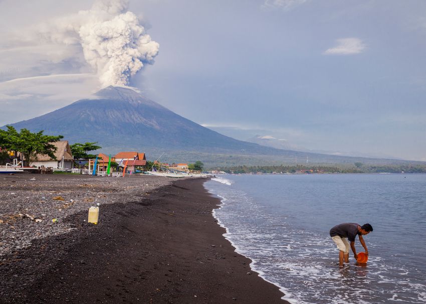
Q uiet since its 1963 eruptions killed more than 1,000 people,
Mount Agung in Indonesia suddenly awoke in September
2017 from its long slumber with hundreds of felt earthquakes
most volcanically active nation. Its volcanoes are legendary
throughout the world, with the notorious 19th-century eruptions at
Mount Tambora (1815) and Krakatau (1883), and the eruption that
that caused great concern for the tens of thousands of people created the giant Toba Caldera in Sumatra (75,000 years ago)—the
living nearby in eastern Bali. Steam emissions from the volcano Earth’s largest volcanic eruption in the past 100,000 years. Just in the
were increasingly visible, and one question rose to the forefront past 20 years, more than 36 volcanoes have erupted, some multiple
of everyone’s mind: was Mount Agung about to erupt again? times, threatening millions of people. The Government of Indonesia
Indonesia’s Center for Volcanology and Geologic Hazards responds to this daunting volcanic threat from CVGHM’s offices in
Mitigation (CVGHM) quickly mobilized, improving monitoring Bandung. From there, dozens of staff members coordinate operations
at 77 small observatories spread out across the 5,000-kilometer-long
at local observatories near Agung and dispatching a rapid-
(3,100-mile-long) archipelago that is Indonesia.
response team to Bali from their headquarters in Bandung, on
For more than 50 years, the United States has worked in
the neighboring island of Java. Soon thereafter, members of the partnership with the Government of Indonesia to reduce the risk of
U.S. Geological Survey’s (USGS) Volcano Disaster Assistance volcanic eruptions and to save lives. Today, the two governments
Program (VDAP) traveled from the United States to assist cooperate through an agreement between CVGHM and VDAP. The
CVGHM with the rapidly escalating volcanic crisis. work is funded by the U.S. Agency for International Development
(USAID) together with the USGS Volcano Hazards Program.
Each year CVGHM and VDAP representatives convene to discuss
priorities for the upcoming 12 months. They outline a series of
training efforts, field campaigns, equipment deployments, and timely
topics that require further exploration and development.
View of Mount Agung, Island of Bali, Indonesia, during its 2017 eruption.
Photograph by Andri Tambunan/Getty Images, used with permission.
U.S. Department of the Interior Fact Sheet 2019–3074
Printed on recycled paper
U.S. Geological Survey April 2020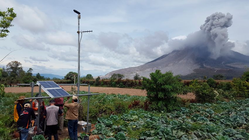
Sinabung

                      Padang            Sumatra
                                                                                                                                                M

INDIAN OCEAN                                                                                                                 INDON
                                                                                                 Java Sea
                                                                     Jakarta Bandung
Map of Indonesia showing volcanoes where
scientists from the U.S. Volcano Disaster                                              Dieng             Surabaya            Bali Lombo
Assistance Program (VDAP) and Indonesian             Tangkubanparahu
Center for Volcanology and Geologic Hazards                                      Java                                    Ijen Batur
Mitigation (CVGHM) have collaborated to                                                   Merapi
deploy monitoring equipment between 2005                                                                Kelud       Raung
and 2020. Red triangles mark the sites of VDAP-                                                                                   Agung
CVGHM collaborations; orange triangles mark
other Indonesian volcanoes.
                                                                                                                       Denpasar

                                                                               Cooperation between the two agencies was greatly accelerated
                                                                        in 2004, when a joint CVGHM-VDAP plan was developed to
                                                                        better monitor the volcanoes in Sulawesi and islands of Indonesia’s
                                                                        remote northeast. With equipment provided by the USAID through
                                                                        government-to-government agreements, the two staffs modernized
                                                                        real-time seismic monitoring at Soputan, Lokon-Empung, and seven
                                                                        other volcanoes in North Sulawesi and the Sangihe Islands. The
                                                                        success of the collaboration led to further equipment deployments
                                                                        and joint work by CVGHM and VDAP—on volcanoes of Java, Bali,
                                                                        Lombok, Flores, and Sumatra. Overall, between 2005 and 2018,
                                                                        VDAP and CVGHM worked together to improve monitoring at 22
                                                                        volcanoes and USAID-donated equipment was installed at more than
                                                                        65 volcanoes.
                                                                               VDAP and CVGHM also share knowledge through training
                                                                        programs. In Bandung and at other Indonesian sites, joint workshops
                                                                        have focused on volcanic earthquakes and deformation, database
                                                                        technologies, hazard mapping, and eruption forecasting and modeling.
                                                                        Field seminars have focused on geologic mapping, aerial photography
                                                                        and photogrammetry, and volcanic gas surveillance. Training
                                                                        abroad for Indonesian and other international volcano scientists and
                                                                        technicians occurs through an annual 7-week course at the University
                                                                        of Hawaii’s Center for the Study of Active Volcanism in Hilo, Hawaii,
    Workshops between collaborators from the U.S. Geological
                                                                        and USGS Cascades Volcano Observatory in Vancouver, Washington,
    Survey (USGS) and Indonesia’s Center for Volcanology and
                                                                        both in the United States. This VDAP-sponsored course is taught
    Geologic Hazards Mitigation focus on best practices for a wide
                                                                        partly by VDAP staff and each year introduces one or more CVGHM
    variety of situations. Here, USGS Volcano Disaster Assistance
                                                                        staff to other volcano observatory staff and students from all over
    Program staff and their Indonesian colleagues review seismic
                                                                        the world. Finally, VDAP supports travel for CVGHM staff to select
    data to identify earthquake characteristics that may be useful
                                                                        international meetings to share their knowledge and research results
    as eruption precursors. Photograph by Jeffrey Marso, USGS.
                                                                        with the global volcanology community.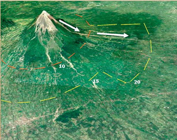
Sangihe
                       Islands                   Awu
                                                Karangetang
                     Mahawu
               Lokon-Empung
                                                 Ruang    Dukono                                 PACIFIC OCEAN
                                               Tongkoko      Ibu
                          Ambang                            Gamkonora
                                              Soputan    Gamalama

       Sulawesi                                             Maluku
Mamuju                                                      Islands

                                                                                                                          New
ESIA                                                                                                                     Guinea
                                                 Banda Sea

ok   Flores
                Paluweh

                                       Timor

           Commonly, CVGHM and VDAP can collaborate during
     volcanic crises without the need for any travel. Modern
     communication tools and satellite technologies permit
     surveillance from space and critical discussions in near-real-
     time. For example, on October 22, 2010, Indonesian scientists
     recognized that the frequently active Merapi volcano was
     experiencing earthquakes, gas emissions, and ground movements
     far more intense than usual. By using available satellite data,
     and tasking additional satellites, VDAP and CVGHM staff were
     able to track growth of a lava dome at the volcano’s summit.
     Cloud-penetrating satellite radar provided images that indicated
     rapid growth of the lava dome, helping CVGHM to recognize the
     potential for large and deadly pyroclastic flows (scorching clouds
     of ash and rock particles that sweep downhill). On November 4,
     based on the remote sensing information and increased seismicity,
     CVGHM called for evacuations to be extended to 20 kilometers
     (12 miles) from the summit. Just hours later, the largest eruption
     at Merapi in 100 years generated pyroclastic flows and surges
     that decimated the landscape, traveling as far as 15 kilometers (9
     miles) from the summit. Overall, 279,000 people were evacuated,
     and at a minimum, 10,000 to 20,000 people who lived in the
     devastated zone were saved by the evacuations.                       Merapi volcano towers above this densely populated part of
           Successful forecasting of volcanic events depends on           central Java in Indonesia—approximately 4 million people
     understanding what has happened in the past and having tools         live within 30 kilometers of the summit. In 2010, the decision
     to monitor and evaluate volcanic signals. VDAP creates and           to extend the evacuation zone from 10 kilometers (red dashed
     distributes software that is used globally to assist volcano         line) to as much as 20 kilometers (yellow dashed line), likely
     observatories with data assessment and interpretation. VDAP          saved more than 10,000 lives when pyroclastic flows and floods
     teams up with global partners to create databases that document      (arrows) raced 15 kilometers down the mountain. Base map
     past activity at volcanoes around the world. These data are used     image from Google, DigitalGlobe, 2017.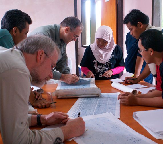
Installation of a telemetered, solar-powered scanning spectrometer in 2016 at Sinabung volcano—which has been continuously erupting since
2013—in Sumatra, Indonesia. The instrument is used to measure the amount of sulfur dioxide gas emitted from the volcano, which helps scientists
understand and forecast volcanic eruptions. Photograph by Christoph Kern, USGS.

in statistical models to help make reliable forecasts. Such tools proved          During increasing volcanic unrest in September and October
helpful in 2015, when VDAP worked with CVGHM to estimate that               2017, more than 130,000 people were evacuated from their homes
lava emissions at Sinabung volcano in northern Sumatra were likely          near Mount Agung. CVGHM and VDAP staff collaborated to install
to extend for a number of years, and that long-term evacuations and         and repair monitoring equipment, improve computer systems, model
community planning might be necessary.                                      potential eruption scenarios, analyze seismic and ground deformation
       One recent focus for VDAP and CVGHM has been at Kawah                data, and develop new strategies for sampling gases in volcanic clouds.
Ijen, a dangerous acid lake in eastern Java. “Wet” volcanoes such           After a month of intense earthquake activity, the volcano temporarily
as Ijen pose different challenges for monitoring because changes in         quieted in mid-October, but then finally erupted in late November
temperature and gas discharge are masked by the presence of large           2017 and into the following year. The eruption was relatively small and
water bodies. The Kawah Ijen lake itself poses a hazard, as slugs of        no one was injured, but the volcanic episode at Mount Agung taught
toxic gas periodically burst through and pose risks to miners, tourists,    valuable lessons to CVGHM and their VDAP collaborators, and further
and local communities. Recently, gas monitoring stations and a              strengthened a notable decades-old partnership.
multinational workshop organized by CVGHM at Kawah Ijen afforded
new insights into the dynamics of gas output from the volcano and                    Jacob B. Lowenstern, Kasbani, John S. Pallister,
the seasonal buildup of toxic gas. Through training and mentorship,                              and David W. Ramsey
CVGHM staff have become experts at deploying and maintaining
USGS-designed and VDAP-donated gas monitoring equipment.                                         Edited by Monica Erdman
       No country faces more volcanic risk and experiences more                               Layout and design by Cory Hurd
erupting volcanoes than Indonesia. By accepting assistance from foreign
countries, CVGHM has been able to make giant strides in growing their                       For more information, contact:
monitoring networks and training their staff. International partnerships                   Volcano Disaster Assistance Program
serve both CVGHM, but also the foreign collaborators that provide                              Jacob B. Lowenstern, Chief
the support. In addition to the United States (through VDAP), Japan,                               jlwnstrn@usgs.gov
Belgium, Australia, France, Singapore, and others assist CVGHM and                                   vdap@usgs.gov
its efforts to mitigate the effects of volcanic eruptions. Together, they
                                                                                  Center for Volcanology and Geological Hazard Mitigation
gain invaluable experience testing new instruments, refining software
                                                                                                       Kasbani, Chief
tools, evaluating protocols to enhance community preparedness, and
                                                                                                    pvmbg@esdm.go.id
understanding volcanism at some of the world’s most active volcanoes.
                                                                                                                       ISSN 2327-6916 (print)
                                                                                                                       ISSN 2327-6932 (online)
                                                                                                                       https://doi.org/10.3133/fs20193074
You can also read