Innovation in meteorology for maritime navigation - CIBM
←
→
Page content transcription
If your browser does not render page correctly, please read the page content below
Innovation in meteorology
for maritime navigation
cooperative and GNSS based observations - data assimilation - weather routing

  COSMEMOS project WORKSHOP
  23 October 2013                   9:00 -17:00

             Port of Livorno
             Venue: Main hall of Corsica Ferries ship “Mega Express Two”

  COSMEMOS project aims at exploiting the amount of information virtually
  available at sea from common sensors on board ships and from innovative
  processing of the new GNSS signals, in order to upgrade fine-scale forecasts and
  generate a new class of services for marine transportation, from safety to cost
  reduction.
  The aim of this workshop is to discuss the adopted approaches and initial
  scientific results of the project in a wider context of international experts.
  The workshop want to combine a deep attention to the different scientific issues
  with an active presence of professional users, towards which comparing the
  capability of the project to fit main needs. Main topics discussed will be those of
  cooperative and GNSS-based observations, data assimilation into local meteo-
  marine models and weather ship-routing, looking at the present state of the art
  and at the most promising directions for future developments.

                                www.cosmemos.eu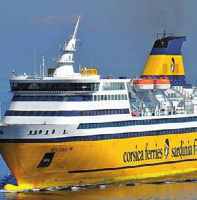
COSMEMOS       innovation in meteorology for maritime navigation

Workshop Programme 23.10.2013
9:00 Opening session
    Greetings from the hosting company.
    Corsica Ferries
    Greetings from the organising company.
    Bernardo Gozzini, Consorzio LaMMA
    Needs and target of ship companies: the vision of Corsica Ferries.
    Gabriele Luschi, Corsica Ferries
    Safety and routing services: the vision of the Italian Coast Guard.
    Italian Coast Guard (TO BE CONFIRMED)
    COSMEMOS: a GNSS-based prototype from observations to services.
    Alberto Ortolani, CNR IBIMET - Consorzio LaMMA

10:00 Observing solutions
    Frontier observing solutions for atmospheric and sea-state assessment
    Chairperson: Prof. Torben Shueler
    GNSS meteorology from ships as moving platforms.
    Torben Shueler, Institute of Geodesy and Navigation, University FAF Munich, Germany
    A Bayesian approach for atmospheric sounding from GNSS signals.
    Andrea Antonini, Consorzio LaMMA
    GNSS-R wave measurements: the Oceanpal instrument .
    Erwan Motte, STARLAB Barcelona
    Smart solutions for data transmission from marine areas.
    Nazzareno Marchese, ITSLab
    The upcoming sensor network in North Tyrrhenian and Ligurian sea for waves and oceanography.
    Carlo Brandini, CNR IBIMET- Consorzio LaMMA

12:00 Weather forecasts
    Upgrading local forecasts by assimilating local data
    Chairperson: Dr. Jordi Moré Pratdesaba
    “Many a little, makes a mickle”: the concept of cooperative data collection towards data assimilation.
    Riccardo Benedetti, Consorzio LaMMA
    Impact of local measurements on limited area forecasts.
    Jordi Moré Pratdesaba, Cataluna Weather Service
    GNSS and radar data assimilation in mesoscale models.
    Thomas Schwitalla, Institute of Physics and Meteorology, University of Hohenheim (DE)

13:00 LUNCH

                                         www.cosmemos.eu
COSMEMOS innovation in meteorology for maritime navigation
Workshop Programme
14:00 Navigation tools and services
Knowledge based tools for safety and cost reduction in marine activities
Chairperson: Prof. Dario Bruzzone
Optimization of ship routes: meteorological navigation “by numerical process” .
Andrea Orlandi, Consorzio LaMMA
Review and state of the art of ship powering, energy efficiency and emissions control, technical
problems and related international rules.
Andrea Coraddu, Dept. of Naval Engeneering (DITEN), University of Genoa
Added resistance in waves, computational techniques and impacts on fuel consumption.
Dario Bruzzone, Dept. of Naval Engineering (DITEN), University of Genoa
Dangerous phenomena in adverse weather and sea conditions: when stability criteria need
to be supplemented by recommendations to the master.
Alberto Francescutto, Dept. of Naval Architecture, University of Trieste
Wave spectral data in ship weather routing.
Roberto Vettor and Carlos Guedes Soares, Centre for Marine Technology &
Engineering, Institute Sup. Tecnico, Lisbon
Algorithmic approaches for optimal ship route planning
Fabio Schoen, Dept. of Information Engineering, University of Florence
Seakeeping analysis and decision support tools for ship operations.
Alessandro Grasso, RINA Services S.p.a.
16:30 Achievements and perspectives
Chairperson: Dr. Enrico Barro
What we have learned today and what for COSMEMOS as a project and as a future service.
Fabio Riva, VITROCISET Belgium
Growing opportunities in Horizon 2020.
Carmen Aguillera, GSA
TECHNICAL NOTES
Workshop participation is free but registration is requested.
To register send an email to: cosmemosworkshop@lamma.rete.toscana.it
English will be the official language of the workshop. No translation provided.
See more on workshop web page: http://www.lamma.rete.toscana.it/cosmemos-workshop
www.cosmemos.euCOSMEMOSproject
innovation in meteorology for maritime navigation
A collaborative project, developing new meteorology data acquisition
and processing at sea, exploiting new GNSS signals, namely Galileo, The Project
aimed at improving marine navigation safety and cost reduction. COSMEMOS
In the maritime navigation - both commercial and yachting - meteorological information is a two years R&D
are crucial. The scarcity of real-time in situ measurements, indispensable for running project, funded by the
precise regional meteo models, is a constrain factor for the improvement of forecasting European
capabilities on local scale. Commission, 7th
Framework Programme,
COSMEMOS propose an original and challenging approach based on: managed by the
An innovative cooperative schema, for gathering marine-weather data, where users of European GNSS Agency
meteo services cooperate with their own data. Available meteo data are provided from grant agreement
private ships in navigation, normally from the sensors already installed, but in some n°287162.
cases also from other two types of innovative sensors, using an adaptive data-transfer
Partners are:
solutions for optimising efficiency and costs.
• VITROCISET Belgium
New sensors aboard, exploiting the value given by the joined GPS and Galileo
(leader)
positioning systems through particular techniques to determine the significant wave • LaMMA consortium
height and the vertical profiles of atmospheric parameters (essentially temperature and (Italy)
humidity). These on-board techniques are completely new. • ITSLab (Italy)
Innovative data processing, through advanced data-fusion procedures to extract • Starlab (Spain)
information from this amount of data, with a proper quality for the assimilation into high • Institute for Geodesy
resolution meteorological models, for improving meteo-marine forecasts. and Navigation
This new class of weather information enables the development of new services for (Germany)
• SPMJ (Great Britain).
maritime navigation, tailored on short-distance navigation, as needed for highly
• Forship S.p.A. (Italy)
detailed weather routing and navigation assistance services at the Mediterranean scale.
owner of the brand
Such services will be based on the integration of accurate models of the characteristics Corsica, Sardinia and
of each ship with improved high-resolution meteo-marine forecasts, also allowing Elba Ferries.
frequent envoyage re-routing.
COSMEMOS è un progetto collaborativo che sviluppa nuove soluzioni per
l’acquisizione e l’elaborazione di dati meteo in mare sfruttando i nuovi
segnali GNSS, in particolare Galileo, per migliorare la sicurezza della
navigazione marittima e ridurne i costi.
Nella navigazione marittima -sia commerciale che da diporto- le informazioni
meteorologiche sono cruciali. La scarsità di misure in situ disponibili in tempo
reale, indispensabili per la meteorologia di precisione, è un fattore limitante per il
miglioramento delle previsioni a scala locale.
COSMEMOS propone un approccio totalmente nuovo basato su:
Un nuovo schema cooperativo per la raccolta di dati meteo-marini, in cui gli utenti di
servizi meteo cooperano con i propri dati. I dati meteo vengono forniti da navi private
in navigazione, misurati dai sensori normalmente già installati, e in alcuni casi anche da
altri due tipi di sensori innovativi, utilizzando soluzioni adattative per il trasferimento
dei dati, per ottimizzarne efficienza e costi.
Nuovi sensori a bordo, che sfruttano il valore congiunto dei sistemi di navigazione
satellitare GPS e Galileo tramite tecniche specifiche per determinare l’altezza
significativa delle onde e i profili verticali di parametri atmosferici (temperatura e
umidità). Queste tecniche per misure a bordo sono completamente nuove.
Elaborazione innovativa di dati, attraverso procedure avanzate di data-fusion per
estrarre informazioni dall’insieme di dati disponibili, con opportune caratteristiche
che ne consentano l’assimilazione nei modelli meteorologici ad alta risoluzione, per
migliorare le previsioni meteo-marine.
Questa nuova classe di informazioni meteo consente lo sviluppo di nuovi servizi Institute for Geodesy
per la navigazione marittima, focalizzati alla navigazione su rotte brevi, necessari and Navigation -
Germany
per l’ottimizzazione meteorologica delle rotte e l’assistenza alla navigazione su scala
mediterranea. Tali servizi saranno basati sull’integrazione di un’accurata modellistica
delle caratteristiche di ogni nave con previsioni meteo-marine ad elevata risoluzione, in
modo da consentire anche il calcolo di correzioni ricorsive lungo la rotta.
www.cosmemos.euYou can also read