NORTH DAKOTA STATE WATER COMMISSION CELEBRATES ONE-YEAR ANNIVERSARY OF NORTH DAKOTA RISK ASSESSMENT MAPSERVICE
←
→
Page content transcription
If your browser does not render page correctly, please read the page content below
FEMA REGION 8 FEBRUARY 2021
NORTH DAKOTA If you require a reasonable
RISK MAP UPDATE accommodation or an alternative
format of available information
such as American Sign Language
format, audio, or other format,
please submit your request to:
Region8AccommodationRequest@
fema.dhs.gov.
NORTH DAKOTA STATE WATER COMMISSION
CELEBRATES ONE-YEAR ANNIVERSARY OF
NORTH DAKOTA RISK ASSESSMENT MAPSERVICE
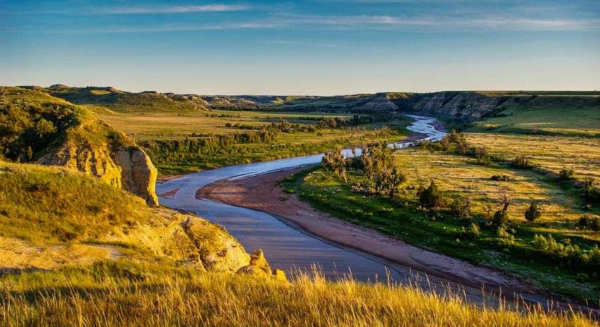
This past fall, the North Dakota State Water Commission celebrated the one-year anniversary of the North Dakota Risk
Assessment MapService (NDRAM). NDRAM is a tool that allows users to visually display current flood risks, including
non-regulatory floodplains from Base Level Engineering (BLE) and effective regulatory floodplains from FEMA’s National
Flood Insurance Program (NFIP).
NDRAM is a joint effort between FEMA and the Water Commission. In 2018, the two organizations partnered to create NDRAM
because two-thirds of North Dakota did not have access to authoritative flood risk data. Without this data, many cities and
rural populations had little information to make local floodplain management regulations and decisions.
BLE forms accurate flood risk data through high-resolution ground elevation data and modeling software. BLE focuses on
unknown, unmodernized, and unmapped areas to provide data for areas without flood maps. North Dakota provided the
ground elevation data, and FEMA funded the engineering analysis through its engineering provider. Together, they created
a BLE dataset for the entire state of North Dakota – the first state to have flood risk data for every county.
NDRAM makes the BLE data and existing state flood maps accessible to the public. It was designed to be a one-stop shop
for flood risk information. NDRAM uses state-of-the-art technology to provide more than 47 terabytes of data that is free
and available for download on the Water Commission website at www.swc.nd.gov.
1
FEMA REGION 8                                                                                                      FEBRUARY 2021
NORTH DAKOTA
RISK MAP UPDATE

NDRAM allows users to view water surface elevations and flood depths; download engineering model data, depth and velocity
grids; and print customized maps. NDRAM also allows residents to type in their address (house number, zip code and county)
to get parcel-specific information. The address look-up feature leverages the state’s 911 location and address information.

NDRAM recently added new innovations in order to enhance the platform’s functionality. When using the NDRAM tool, the users
can now access a weather tab that displays current warnings, observed river stages, significant river flood outlooks, and snow
water equivalent. These additional features provide increased capabilities, expertise, and information for residents, emergency
managers and community leaders seeking flood information.

To celebrate the one-year anniversary, the Water Commission launched a new NDRAM tutorial video. The tutorial was created
to provide additional support to users. The nearly ten-minute video is a step-by-step guide on how to navigate NDRAM and
helps users access useful data. You can view the video at www.swc.nd.gov.

                                                 A screenshot of the NDRAM, which provides flood risk data for every county in North Dakota.

                                                                                                                                               2
FEMA REGION 8                                                                                               FEBRUARY 2021
NORTH DAKOTA
RISK MAP UPDATE

The tutorial is just one of many outreach efforts the Water
Commission has implemented to encourage public awareness                 You can access the NDRAM at www.ndram.swc.
and use of the robust NDRAM tool. Water Commission                       nd.gov or contact Laura Horner, North Dakota’s
staff members provided several training opportunities and                Risk MAP Coordinator at lmhorner@nd.gov for
demonstrations of the platform at various events in 2019,                more information.
including the LaMoure County Flood Preparedness event.
Water Commission staff provided additional outreach to the
City of Mandan and Morton County staff, the Emergency Management Institute – Cooperating Technical Partners (CTP), the
Morton County Water Board, and North Dakota Floodplain Administrators. Staff also presented demonstrations of NDRAM
to elected officials, emergency managers, water resource districts, and community leaders.

NDRAM is critical to developing flood risk data and benefits the entire state. The tool replaced outdated information,
facilitated the phasing-out of paper-only map inventory, and provided data to counties where there was none. NDRAM can
also be used as the best available data for mitigation and post-disaster grant applications, bolstering efforts in North Dakota
communities to better prepare and plan for natural disasters. Finally, NDRAM has helped prioritize FEMA flood mapping
studies for future funding.

In recognition of NDRAM’s success and benefits, CTP Collaboration Program recognized the tool as a Best Practices Case Study.
The Best Practices Case Study noted that throughout the past year, NDRAM has provided beneficial flood risk information for the
whole state of North Dakota and complimented three noteworthy components of the tool. It has: 1) provided a statewide BLE
dataset; 2) enhanced engagement and outreach; and 3) created data sharing in a user-friendly format.

                                                                                                                                  3
FEMA REGION 8                                                                                                                 FEBRUARY 2021
NORTH DAKOTA
RISK MAP UPDATE

PREPARING FOR SPRING SNOWMELT                                                            HAVE FLOOD INSURANCE?
Quickly warming temperatures in the spring cause snow to                                 Below are some additional actions you can take now
melt and, depending on conditions, can result in flooding.                               to prepare for potential flood conditions this spring:
The amount of flooding depends on a variety of different
factors, including depth of snowpack, how quickly the snow                               ◆ Check your sump pump and install
melts, how saturated the ground was going into winter, and                                   a battery backup.
rainfall or snowfall amounts in the spring.1                                             ◆ Install a water alarm.
                                                                                         ◆ Clear debris from gutters and downspouts.
Flooding is one of the most common and widespread
disasters and can cause significant damage and devastation.                              ◆ Anchor fuel tanks.
In 2019, flooding throughout the spring and summer cost                                  ◆ Itemize and take photos of possessions.
more than $6.2 billion in damages and caused four deaths                                 ◆ Move furniture, valuables and important
across North Dakota, South Dakota, Nebraska, Iowa, Missouri,                                 documents to a higher space in your home.
Minnesota, Wisconsin and Michigan.2                                                      ◆ Put together an emergency supply kit.
                                                                                         ◆ Make a pet plan.
This past spring, the Red River at Grand Forks reached
                                                                       ◆ Take photos and videos to conduct
moderate flood levels, and the spring snowmelt was
                                                                          household inventory.
manageable, compared to 2019. But while flooding in spring
2020 was more contained, this year’s snowmelt could still lead         ◆ Sign up for local weather alerts – Stay informed!
to delays and challenges with crop planting and cause damage
to roads, bridges, levees and dams.3 According to FEMA insurance specialists, just 1 inch of water can cause $25,000 worth of
damage, and the average flood insurance claim over the past five years was $69,000.

Predictions and spring outlooks will be available from the National Weather Service in February and March 2021, but you can
take steps now to prepare for snowmelt.

PREPARE WITH FLOOD INSURANCE:
For property owners, the best thing you can do is buy or renew flood insurance. Most traditional homeowners and renters
insurance do not cover flood damage, so it’s important to check and protect yourself against the damage a flood can bring.

You can purchase flood insurance at any time, but it can take up to 30 days before the policy goes into effect, so it is best to
purchase early before flooding happens.

Flood insurance covers flooding from weather events, including
overflow of inland waters (such as a lake or river), pooling or                             The NFIP offers coverage for your building,
runoff of surface waters from any source like heavy rainfall,                               belongings and basement. Visit floodsmart.gov
mudflows, and collapse of land along the shore of a lake or other                           for more information and to get coverage today.
body of water. All conditions that will be useful to North Dakotans!

1
    https://weather.com/safety/winter/news/2020-02-26-march-weather-winter-spring-snow-rain-wind-severe
2
    https://www.climate.gov/news-features/blogs/beyond-data/2010-2019-landmark-decade-us-billion-dollar-weather-and-climate
3
    https://weather.com/safety/floods/news/2020-02-13-spring-flood-risk-plains-midwest-south

                                                                                                                                                  4
FEMA REGION 8 FEBRUARY 2021
NORTH DAKOTA
RISK MAP UPDATE
YOUR COUNT Y’S RISK MAP PROGRESS
YOUR COUNTY RISK MAP PROGRESS All 53
Counties
YEAR
1 North Dakota is the f irst state to have
risk analysis completed in every county
Phase 1
DISCOVERY Oliver
MEETING Mercer
McLean
Logan
5 Active Risk MAP Projects Golden Valley
(non-legacy) in North Dakota– FY19 Funded
more detailed f lood risk
information is being created:
Phase 2 Stutsman
LaMoure
ENGINEERING Dickey
& MODELING
FY18 Funded
YEAR Emmons
2-4 Williams Burleigh
FY15 & FY 18 Funded Phase 3
FLOOD RISK FY18 Funded
REVIEW
Stark
FY17 Funded
Phase 4
FLOOD RISK
PRELIMINARY Ward
MAP RELEASE
FY07 Funded
Phase 5
APPEAL
PERIOD
YEAR
3-5+
Phase 7 Phase 6
ADOPTION LETTER OF FINAL
& COMPLIANCE DETERMINATION
Phase 8 Phase 9
RESILIENCE EFFECTIVE
Timing and sequence
MEETING MAPS
may vary by county
5You can also read