The Future Direction of Flood Hazard Mapping in the US The Role of TFMA and TMAC to Help FEMA Make a More Resilient Nation - Scott Edelman
←
→
Page content transcription
If your browser does not render page correctly, please read the page content below
Scott Edelman                               February 19, 2015

                             The Future Direction of Flood
                             Hazard Mapping in the US

The Role of TFMA and TMAC
to Help FEMA Make a More Resilient Nation
What does our 2050 future look like?
450MM
US Population
315MM
55MM
Texas Population
40MM
27MM 25%
Floodplains
What is TMAC?

                             TMAC = Technical Mapping
                                Advisory Council

 The TMAC provides advice
and recommendations to the
  Administrator of FEMA.

                             The duties of the TMAC are
                              solely advisory in nature.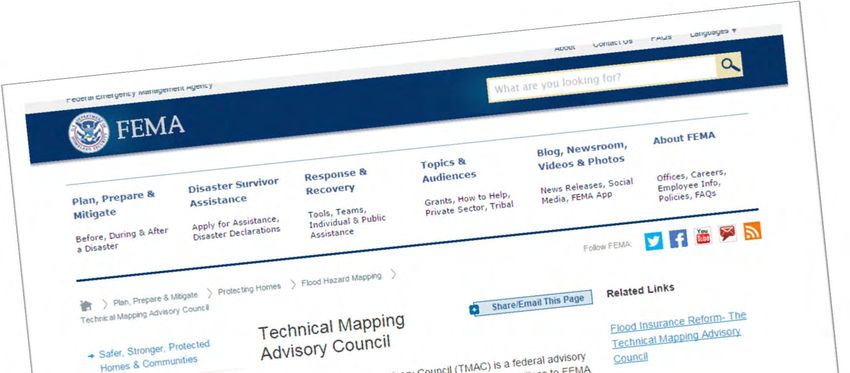
TMAC Overview Federal advisory committee established by the Biggert-Waters Flood Insurance Reform Act of 2012 amended by the Homeowner Flood Insurance Affordability Act of 2014
Objectives of TMAP
How to improve in a cost-effective
manner the:
– Accuracy, general quality, ease of use, and
distribution and dissemination of flood
insurance rate maps and risk data; and
– Performance metrics and milestones
required to effectively and efficiently map
flood risk areas in the United States.
Objectives of TMAP
Mapping standards and guidelines for:
– Flood Insurance Rate Maps (FIRMs); and
– Data accuracy, data quality, data currency,
and data eligibility;
How to maintain, on an ongoing basis,
FIRMs and flood risk identification; and
Procedures for delegating mapping
activities to State and local mapping
partners.
Objectives of TMAP
The TMAC recommends to the
Administrator and other Federal
agencies participating in the Council:
– Methods for improving interagency
and intergovernmental coordination
on flood mapping and flood risk
determination; and
– A funding strategy to leverage and
coordinate budgets and expenditures
across Federal agencies.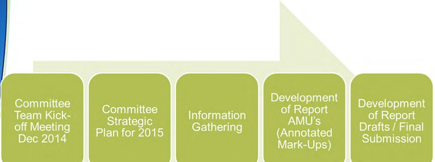
TMAC Reporting Requirements

                                 Anticipated
Report Name                      Delivery

Review Report                    TBD

Future Conditions Risk
                                 October 2015
Assessment and Modeling Report

TMAC Annual Report               October 2015
Report Requirements

Legislative Requirements                                     Required Reports

                                                             Future Conditions                       TMAC Annual Report
                                                             Risk Assessment      National Mapping     of Activities and
                                                               and Modeling      Program Technical    Recommendations
                                                                  Report               Review        to the Administrator
Consult with scientists and technical experts, other
Federal Agencies, States, and local communities to
develop recommendations on how to:
•   Ensure FIRMs incorporate the best available climate
    science to assess flood risks
•   Ensure that FEMA uses the best available
    methodology to consider the impact of:
      •    the rise in sea level
      •    Future development on flood risk
Recommend to the Administrator how to improve in a
cost-effective manner the accuracy, general quality, ease
of use, and distribution and dissemination of FIRMs and
risk data
Recommend to the Administrator how to improve in a
cost-effective manner the performance metrics and
milestones required to effectively and efficiently map
flood risk areas in the United States
Recommend to the Administrator mapping standards and
guidelines for Flood Insurance Rate maps

Recommend to the Administrator mapping standards and
guidelines for data accuracy, data quality, data currency,
and data eligibility
Report Requirements

Legislative Requirements                                      Required Reports

                                                              Future Conditions                       TMAC Annual Report
                                                              Risk Assessment      National Mapping     of Activities and
                                                                and Modeling      Program Technical    Recommendations
                                                                   Report               Review        to the Administrator
Recommend to the Administrator how to maintain, on an
ongoing basis, Flood Insurance Rate maps and flood risk
identification
Recommend procedures for delegating mapping activities
to State and local mapping partners

Recommend to the Administrator and other federal
agencies participating in the Council methods for
improving interagency and intergovernmental
coordination on flood mapping and flood risk
determination
Recommend to the Administrator and other federal
agencies participating in the Council a funding strategy to
leverage and coordinate budgets and expenditures across
federal agencies
The FEMA Administrator shall implement a flood mapping
program for the National Flood Insurance Program, only
after review by the Technical Mapping Advisory Council,
that, when applied, results in technically credible flood
hazard data in all areas where Flood Insurance Rate maps
are prepared or updated. TMAC will deliver their review
report to the Administrator and the Administrator must
also submit the TMAC’s report to Congress
TMAC Timeline
Report Development Process
TMAC Strategic Plan 2015 Provides overall guidance What items TMAC should accomplish in 2015 vs future years – Congressional mandates – TMAC committee member recommendations – Past report recommendations
Current Phase - Information Gathering

                     Determine who should
                     be invited to speak at
                      TMAC or workgroup

                                              Determine
      Information
                                              what data
       meetings
                                              or analysis
         can be
                                              may need
       in-person
                                                 to be
        or virtual
                                              generated

                      Focuses speakers on
                     issues TMAC wants to
                        address in 2015
Subject Matter Experts/Technical Advisors The TMAC may hear from subject matter experts/technical advisors (“SMEs”) who will be asked to provide specialized information or assistance as appropriate and approved by the Designated Federal Officer (DFO). Individual TMAC members may request SMEs, by expertise or skillset, to appear before the TMAC, as needed. Member requests will be made to the Chair for consideration and consultation with the TMAC DFO. FEMA will not compensate SMEs for their services but they may be reimbursed for travel and lodging expenses.
The TMAC will hold quarterly plenary sessions Meeting agendas are developed by the DFO in coordination with the TMAC Chair Meeting notices are published in the Federal Register 15 days prior to the meeting
Who is a part of TMAC?
Member                TMAC Category                 Title and Organization
Doug Bellomo          FEMA Designee                 Director, Risk Analysis Division, FEMA
                                                    Director, National Geodetic Survey, National Oceanic nad Atmospheric
Juliana Blackwell     NOAA Designee
                                                    Administration (NOAA)
Nancy Blyler          USACE                         Geospatial Community Leader, U.S. Army Corps of Engineers (USACE)
Richard Butgereit     State GIS                     GIS Administrator, Florida Division of Emergency Management
Mark DeMulder         USGS                          GSGS National Geospatial Program
                                                    Director, Emergency Management Division, Geospatial and Technology
John Dorman           State CTP
                                                    Management Office, North Carolina State Government
                                                    Director, State Cooperating Technical Partner (CTP) Program and National Flood
Leslie Durham         State CTP
                                                    Insurance Program (NFIP), Alabama
Scott Edelman         Mapping                       Division Director for North America, AECOM Water Resources
Steve Ferryman        State Mitigation Officer      Mitigation and Chief Engineer, Clark County Regional Flood Control District
                      Regional Flood and            General Manager and Chief Engineer, Clark County Regional Flood Control
Gale Wm. Fraser, II
                      Stormwater Management         District
                                                    Senior Policy Advisor, Mayor’s Office of Long-Term Planning and Sustainability,
Carrie Grassi         Local CTP
                                                    New York City
Christopher Jones     Engineering                   Registered Professional Engineer
                                                    Professor of Decision Sciences and Public Policy, Department of Operations and
Howard Kunreuther     Risk Management
                                                    Information Management, The Wharton School, University of Pennsylvania
Wendy Lathrop         Surveying                     President and Owner, Cadastral Consulting, LLC
                                                    Senior Project Engineer, Urban Drainage & Flood Control District’s Floodplain
David Mallory         Local CTP
                                                    Management Program, Denver, Colorado
Robert Mason          DOI Designee                  Deputy Chief, Office of Surface Water, Department of Interior (DOI)
Sally Ann McConkey    Floodplain Management         Illinois State Water Survey Prairie Research Institute, University of Illinois
                      State NFIP Coordination
Christine Shirley                                   NFIP Coordinator, Oregon State
                      Office
Cheryl Small          Flood Hazards Determination   Vice President of Operations, CoreLogic Flood Services
TMAC Resources • www.fema.gov/TMAC
TMAC Potential Items for Future Conditions Report Map accuracy and uncertainty Human induced change Environment induced change Best available science Building design and construction Data requirements Riverine / Coastal
Clarifying
Confusing
Standards
for Public
We need to inform the public on the
underlying assumptions

        All structures operate correctly
                 and will not fail

        Structures will not be obstructed
                   with debris

            Only existing conditions
                are considered
Structures will operate properly
ASSUMPTION
and will not failStructures will not be ASSUMPTION blocked with debris
Only existing conditions are
ASSUMPTION reflected on the maps
FEMA / AECOM
National Climate Change Report
Released
by
Whitehouse
June 2013
Example Change: Q100
SIGNIFICANT TECHNICAL SIGNIFICANT FINANCIAL
FINDINGS: FINDINGS IN TODAY’S DOLLARS:
By Year 2100 riverine floodplains Average loss cost per policy will
will increase by 50% in size, increase by approximately 90%
Coastal areas will increase by Individual premiums will increase
55% in size 10% to 40%We have confused the public with different definitions Bridge Standard Flood Plain Elevation
Statistics are used to predict the future
Statistics use confidence limits to show
range of likely results
Statistics use confidence limits to show
range of likely results
What Causes Sea Level to Change? Thermal expansion (~ 1 meter potential) Water exchange with continents (potential) – Greenland ice (7 meters) – Antarctic ice (60 meters) – Mountain glaciers (0.5 meter) – Terrestrial water storage variations (< 0.5 meter) – Other (halosteric, etc.) SOURCE: Doug Marcy, NOAA December 2014 ∆SL Total = ∆SL Thermosteric + ∆SL Greenland + ∆SL Antarctica + ∆SL Glaciers+ ∆SL Storage+ ∆SL Other
Greatest source of uncertainty?

SOURCE: Doug Marcy NOAA December 2014c   Source: NASA
Just give me a number – please!

SOURCE: Doug Marcy NOAA December 2014c
Variability within IPCC projections
Global SLR scenarios

We also know of course that sea level change will
vary regionally and locally
SOURCE: Doug Marcy NOAA December 2014c; Parris et al, 2012
Intergovernmental panel on
climate change
IPCC has recommendations
for uncertainty
IPCC Uncertainty
How can TFMA help? Contribute on areas that can be improved Submit a whitepaper on TFMA position Be available for SME’s
You can also read