JOINT UNESCO WORLD HERITAGE CENTRE/ ICOMOS ADVISORY MISSION TO THE WORLD HERITAGE SITE OF THE HISTORIC CENTRE OF FLORENCE, ITALY - REPORT 22-25 ...
←
→
Page content transcription
If your browser does not render page correctly, please read the page content below
REPORT

JOINT UNESCO WORLD HERITAGE CENTRE/ ICOMOS
ADVISORY MISSION TO THE WORLD HERITAGE SITE OF
THE HISTORIC CENTRE OF FLORENCE, ITALY

22-25 May 2017
Cover: View across the city towards Santa Croce, from the belvedere of the Bardini Garden

This report is jointly prepared by the mission members: Ms Isabelle Anatole-Gabriel
(UNESCO World Heritage Centre) and Mr Paul Drury (ICOMOS International).

                                                2
CONTENTS
ACKNOWLEDGEMENTS ...................................................................................................................... 5
EXECUTIVE SUMMARY AND RECOMMENDATIONS ................................................................. 6
1.      BACKGROUND TO THE MISSION ........................................................................................... 8
2.      NATIONAL AND LOCAL POLICY FOR PRESERVATION AND MANAGEMENT ...... 9
3.      IDENTIFICATION AND ASSESSMENT OF ISSUES .............................................................. 10
     3.1.       Introduction ............................................................................................................................. 10
     3.2.       Airport expansion ................................................................................................................... 11
     3.3.       The High Speed Rail Link ...................................................................................................... 12
     3.4.       Mobility in the historic centre and the developing tram system .................................. 13
     Context ................................................................................................................................................. 13
     The strategic tram network.............................................................................................................. 14
     A possible underground metro link? .............................................................................................. 15
     The impact of the tramways ............................................................................................................. 15
     3.5.       Parking in the historic centre ............................................................................................... 16
     3.6.       Waste Management ................................................................................................................ 18
     3.7.       Re-use of public buildings in the Historic Centre............................................................ 19
     Introduction.......................................................................................................................................... 19
     A case study: the relocation of the Law Courts .......................................................................... 20
     Other city projects ............................................................................................................................. 21
     3.8.       The Management Plan and Heritage Impact Assessment............................................... 21
     3.9.       Managing tourism .................................................................................................................... 23
     The need for a tourist strategy ........................................................................................................ 23
     Use of public space in the historic centre ..................................................................................... 25
4.      ASSESSMENT OF THE STATE OF CONSERVATION OF THE PROPERTY .................. 27
     4.1.       Management ............................................................................................................................. 27
     4.2.       Historic fabric .......................................................................................................................... 27
     4.3.       Infrastructure ........................................................................................................................... 28
     4.4.       Integrity and Authenticity...................................................................................................... 28
5.      CONCLUSIONS AND RECOMMENDATIONS .................................................................... 30
     Infrastructure works........................................................................................................................... 30
     Use of monumental complexes........................................................................................................ 30
     Management and Heritage Impact Assessment ............................................................................ 31

                                                                               3
6.     ANNEXES ......................................................................................................................................... 32
     6.1. Statement of Outstanding Universal Value, as retrospectively adopted by the
     World Heritage Committee in 2014 .............................................................................................. 32
     6.2.     Terms of Reference of ICOMOS Advisory Mission, May 2017 ................................... 35
     6.3.     Composition of the Mission Team ...................................................................................... 37
     6.4.     Itinerary and Programme ...................................................................................................... 38
     6.5.     Participants ............................................................................................................................... 44
     6.6.     Illustrations ............................................................................................................................... 47

                                                                             4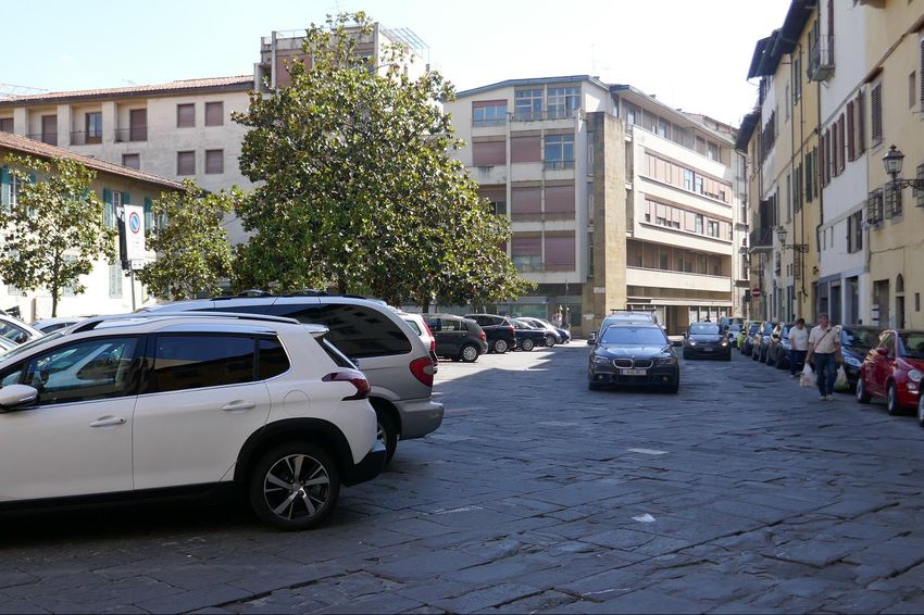
ACKNOWLEDGEMENTS

 The two members of the mission sincerely thank the authorities of the Republic of Italy,
 represented by the Ministry of Cultural Heritage, Activities and Tourism, for their support
 and assistance. Special thanks are due to Adele Cesi, World Heritage Focal Point, who was
 present throughout the mission, who with her colleagues contributed so effectively to its
 success.

 The Municipality of Florence were unfailingly generous with their expertise, time and
 hospitality. Dario Nardella, the Mayor, both in formal and informal meetings, took great
 interest in our work, demonstrating his commitment to the cultural heritage of the city at
 the highest level. Carlo Francini, Site Manager of the World Heritage Property, guided us
 expertly through the programme and the city, drawing on his deep knowledge of Florence
 and the organisations involved in managing it, abily supported throughout by Chiara
 Bocchio, Heritage City_Lab - World Heritage Office of the City and University of Florence.
 We are especially grateful to them for their role in ensuring the success of the mission,
 and for making our stay so enjoyable. We are also grateful to the many other
 representatives of the municipality who joined our sessions and made available their
 particular expertise and knowledge, along with staff of the University of Florence who are
 working on projects with the city, and of Rete Ferroviaria Italiana and Florence Airport
 who presented their projects to us.

 We were also pleased to be able to hear the views of civil society organisations, including
 the Angeli del Bello Foundation and several organisations who are concerned about the
 effects of proposed infrastructure works and the changing character of the city, particularly
 in the face of tourist pressures. We have taken these into account in arriving at our
 conclusions.

                                             5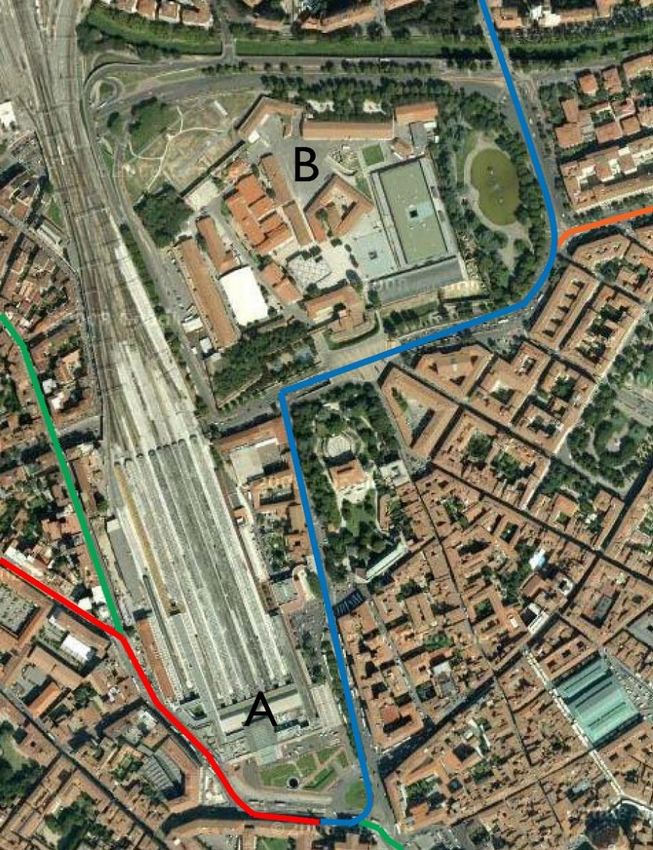
EXECUTIVE SUMMARY AND RECOMMENDATIONS

 Maintaining a balance between tourism and sustaining other aspects and functions of the
 life of the historic City of Florence as a metropolitan centre is a matter of constant
 negotiation between competing interests, in which every decision can have wider
 consequences. The proposed new airport runway and high-speed rail link will not, in the
 mission’s opinion, cause harm to the OUV of the property (indeed the former has benefits
 for the setting of two of the (separately inscribed) Medici villas), but will change the number
 and potentially the type of visitors to the city.

 Great progress has been made in implementing a sustainable movement strategy for the
 historic centre, with the introduction of the first tram line, limitations on car use, greater
 pedestrianisation of the public realm, and electric vehicles. Completion of the strategic
 tram network, in stages around the Viali di Circonvallazione, and with a loop to the Piazza
 San Marco early in the programme, is desirable, taking large motor buses out of the centre
 and contributing to the tourism management strategy. However, in the mission’s opinion
 an aspiration for an underground tram line across the historic centre (but not currently in
 any programme) should be decisively abandoned, because of risks of subsidence, the impact
 of stations, and conflict with a strategy of encouraging tourists to take ‘alternative
 pathways’ to and from the centre.

 The mission considered the possibility of a car park under the Piazza Brunelleschi against
 this background of progress in transforming the environment of the historic centre. While,
 if technical issues can be resolved, the project (including replacing a redundant university
 laboratory) might be achieved with limited harm to the OUV of the property, creating
 public car parks in the historic centre accessed other than directly from the Viali di
 Circonvallazione was contrary to the content, trend and benefits of current policy. Proposals
 (including this one) should be firmly resisted, in line with City policy, despite the special
 pleading that will inevitably be associated with them.

 In the Mission’s view the City’s underground waste containers represent a very significant
 improvement over the previous (and standard) approach of surface level bins. The system
 is as neat and unobtrusive as its function permits. The archaeological sampling of the city
 through the excavation of the pits is in effect a research project delivering useful results.

 The City’s action, after the removal of the Courts, has secured appropriate new uses for
 the vacated buildings, setting an example in bringing their own staff into historic buildings
 in the centre, while securing investment in and a new public-facing use for a monumental
 building on terms in which the City retains the long-term interest in the building. The City
 is taking an active role in securing new uses, more rapidly than was the case with the
 Murate complex, and progress is being made to secure a new use for former convent of
 Sant’Orsola. While overall the condition of the historic fabric is good, a systematic
 approach to identifying and securing the future of unused and/ or deteriorating buildings
 that make a contribution to OUV could be helpful, alongside the very useful HECO
 initiative aimed at encouraging appropriate repair being piloted by the site management.

                                              6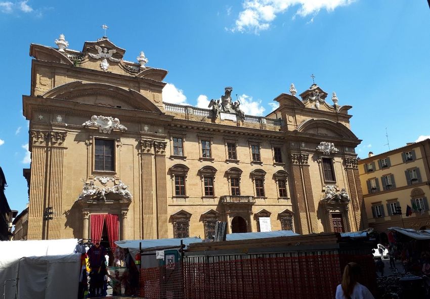
The 2016 revision of the Management Plan is commendably strategic, based on extensive
consultation. It would be improved (at the next review) by identifying more clearly how
the Outstanding Universal Value is expressed through the physical and social fabric.
Heritage Impact Assessment should be embedded as a process in managing the city, and
particularly for infrastructure projects, should begin when concepts are first suggested and
be developed through and influence all subsequent stages of project development.

The mission supported the City’s approach to its emerging tourist strategy, and ongoing
initiatives to spread the load beyond the small core area where the dominance of tourism
is tending to erode the living character and culture of the city. The sequence of city
regulations (2010-17) illustrates how difficult it can be to address issues which face not
only Florence but many other heavily-visited historic cities. The city is to be commended
for its courage and determination to do so, providing an example from which others may
learn.

We recommend that the state party, through the Municipality of Florence:

R1 Consider the consequences of improved high-speed rail and airport capacity in
developing its tourist strategy, particularly the risk of increasing, both absolutely and in
proportion, the number of short-stay visitors.

R2 Definitively abandon the concept of a tramway link under the city core, both because
of the risks it would pose to the historic fabric and archaeology, and because a fast link
direct to the centre would be incompatible with the emerging visitor strategy of spreading
the load.

R3 As a general principle, not allow the creation of any more public car parks in the historic
centre accessed other than directly from the Viali di Circonvallazione, on the grounds that
such proposals are in conflict with the City’s commendable sustainable movement strategy
for the historic centre; and specifically to reject the proposal for the Piazza Brunelleschi.

R4 Specifically develop and maintain a register of buildings (regardless of ownership) that
contribute to the OUV of the city, but are ‘at risk’ as a result of under-use and/or decay,
as a basis for encouraging action by both public and private owners.

R5 At the next review of the management plan, identify more clearly how the Outstanding
Universal Value is expressed through the physical and social fabric, defining the attributes
of the site which carry its Outstanding Universal Value.

R6 Heritage Impact Assessment informed by the Guidance on Heritage Impact Assessments
for Cultural World Heritage Properties (ICOMOS, 2011) be embedded as a process in
managing the city. For infrastructure projects, it should begin when concepts are first
suggested, with a correspondingly strategic assessment of their potential impacts (both
direct and consequential) on cultural heritage, particularly OUV. HIA should then be
developed and applied through options appraisal and all subsequent stages of project
development.

                                            7
1. BACKGROUND TO THE MISSION

 The historic centre of Florence was inscribed on the UNESCO World Heritage List in
 1982 (no. 174) under criteria (i), (ii), (iii), (iv) and (vi). The boundary, drawn tightly around
 the edge of the formerly walled centre of the city, was amended by the addition of an
 extensive buffer zone in 2015.

 Since inscription, the World Heritage Committee has considered two potential threats to
 the property, a terrorist car bomb in the centre, near the Uffizi (1993), and the potential
 impact of high tension power lines on the site’s setting (1998).

 The State Party of Italy invited the 2017 ICOMOS Advisory Mission primarily to assess and
 advise on planned infrastructure projects within the World Heritage property and its buffer
 zone, most of which concern transport to the city and movement within it. The final Terms
 of Reference are at Annexe 6.2. In summary, major projects include the enlargement of
 the airport, the completion of the High-Speed Train line ultimately connecting Naples to
 Milan via Florence and Rome, the construction of tramway lines in and around the historic
 centre, the management of people and motor vehicles within it, waste management within
 the historic centre, and the re-use of public buildings. Advice was specifically sought on the
 process of preparing Heritage Impact Assessments.

 The proposed airport expansion would also affect (positively) the setting of two of the
 Medici Villas and Gardens in Tuscany, inscribed on the List in 2013 (no. 175) under criteria
 (ii), (iv) and (vi).

                                               8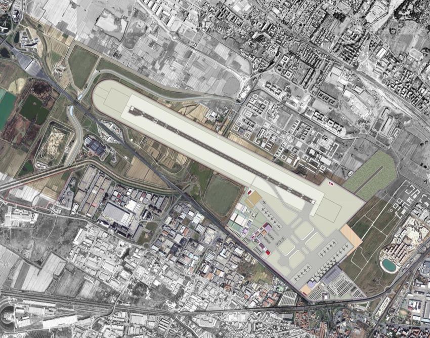
2. NATIONAL AND                     LOCAL          POLICY         FOR       PRESERVATION               AND
   MANAGEMENT

    The Ministry for the Heritage, Cultural Activities and Tourism (Ministero dei Beni e le Attività
    Culturali e del Turismo, ‘MiBACT’) is responsible for cultural heritage at national level, and
    thus for overseeing Italy’s responsibilities under the World Heritage Convention. Italy has
    also ratified the Granada (in 2015), Valetta (in 2015) and Florence (in 2006) Conventions
    of the Council of Europe, respectively relating to architectural heritage, archaeological
    heritage, and landscape.1

    The Heritage and Landscape Codex (2004),2 which consolidated legislative provisions, states
    as a principle that public bodies shall ensure both the conservation and the public
    enjoyment of their cultural heritage.3 The definition of cultural heritage is wide. MiBACT
    fulfils its responsibilities under the code through a regional structure, so in Tuscany as
    elsewhere there is a regional secretariat and technical/ scientific Soprintendenze responsible
    for all matters and decisions related to heritage and landscape protection and valorisation,
    including planning restrictions and the granting of permits. Municipalities, including
    Florence, play a major role in managing and promoting their cultural heritage, investing
    heavily in the restoration and maintenance of their historic assets, under the supervision
    of the Ministry. Nationally, from the start of the 21st century, public/private partnerships,
    sponsorship and donations from both charitable foundations and private sources have
    become more important, especially in consequence of declining public expenditure (2009-
    15). Tax relief is given on donations to and expenditure on cultural heritage, and subject to
    funding being available (which in recent years it rarely has been) the state can contribute
    to conservation work by private owners. 4

    Spatial planning in the City of Florence is governed by the Structure Plan (2010, revised
    2014) and the Town Planning Regulations (2015). The latter provide for management of
    the skyline in the buffer zone to protect the setting of the historic centre, and govern
    ‘transformations’ (modifications in the use or form of buildings) and public works during
    the period 2015-20, within the strategic framework provided by the Structure Plan.
    Provisions were subject to a Strategic Environmental Evaluation, adopted simultaneously
    (2014/15). Building Regulations (approved July 2015) include (in Part III) provisions on
    ‘Decorum and protection of the urban image’, governing external works on buildings,
    particularly those overlooking the street or public spaces. These documents in total form
    a comprehensive and up-to date framework for managing the city fabric, based on
    conservation and restoration. The current World Heritage Site Management Plan (2016) goes
    beyond the need to preserve and enhance the city’s physical fabric, to embrace maintaining
    and increasing relations between the traditional socio-economic activities and the cultural
    heritage of the city.

1
  http://www.coe.int/en/web/conventions/full-list
2
  Delegated decree 42/2004, as amended – see 2016 Management Plan, p54
3
  Art 1.3; 1.4 places wider responsibilities on national and local government, to ensure and sustain its
conservation and foster its public enjoyment and enhancement (UNESCO Cultural heritage laws database)
4
  Additional background information from the Council of Europe Compendium of cultural policies and trends in
Europe: http://www.culturalpolicies.net/web/countries-profiles-cr.php

                                                      9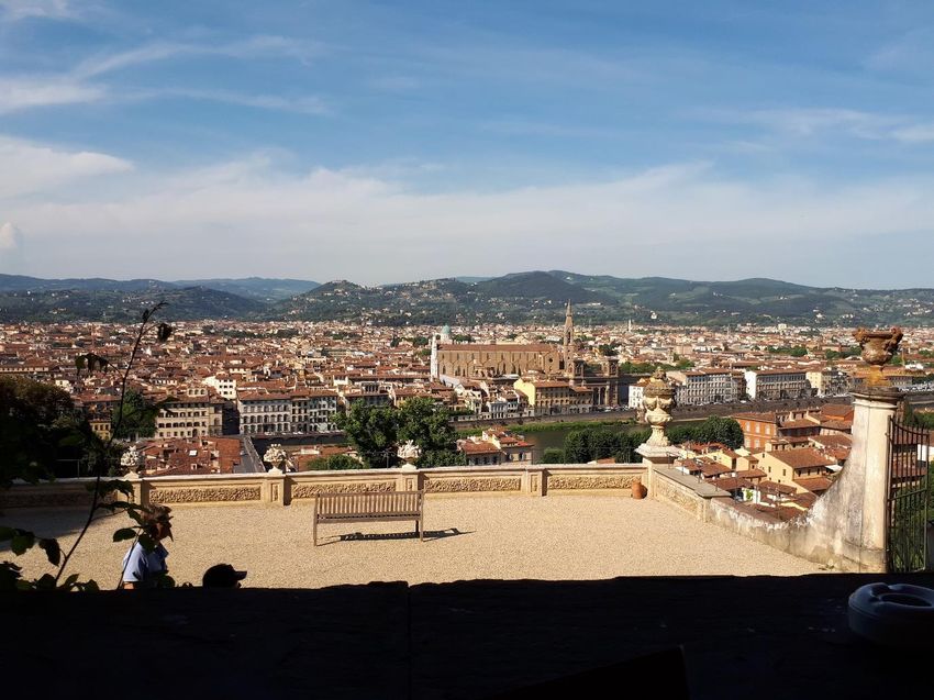
3. IDENTIFICATION AND ASSESSMENT OF ISSUES

      3.1. Introduction

      ‘The Historic centre of Florence can be perceived as a unique social and urban achievement, the
      result of persistent and long-lasting creativity, which includes museums, churches, buildings and
      artworks of immeasurable worth. Florence had an overwhelming influence on the development of
      architecture and the fine arts, first in Italy, and then in Europe. It is within the context of Florence
      that the concept of the Renaissance came to be. This heritage bestows upon Florence unique
      historical and aesthetic qualities’.5

      The cultural values of Florence have drawn scholars and tourists over centuries, but
      accommodating visitors is just one aspect, albeit an important one, of the role and
      economy of the city as a whole and the historic centre, the World Heritage property
      within the line of the former walls, in particular. It is a university city (although the main
      campus of the University of Florence has moved outside the historic centre), with many
      foreign universities maintaining institutes in Florence; and it is the commercial, retail and
      cultural centre of a prosperous metropolitan area. An impression that the historic centre
      is dominated by the demands of tourism soon dissipates as one moves beyond a corridor
      between the railway station, the Duomo, and the Palazzo Pitti across the Ponte Vecchio.
      Especially, but by no means wholly, to the south, north and east of this core, the varied
      life of a modern city with a substantial established population continues within its historic
      fabric.

      Maintaining a balance between tourism and sustaining other aspects and functions of the
      life of the city is a matter of constant negotiation between, and balancing of, competing
      interests, moderated by the Mayor and city authorities. Florence would be diminished if
      activities appropriate to the centre of a metropolitan region were displaced from the city
      core by mass tourism, but maintaining them demands easy access by people from the
      region to the centre. Managing movement of people to and around the city, the balance
      between public and private transport, affects almost every aspect of the social and
      economic life and potential of Florence.

      The city authorities have gradually changed how the limited street space is used, how
      competing interests are balanced. This represents an ongoing process of incremental
      change, at a rate that leads public opinion but maintains majority public support. The
      infrastructure projects considered in this report are part of that process, responses to
      current demands which bring consequences beyond physical change and its effects on the
      Outstanding Universal Value of the place, some immediate, some consequential and so
      inherently less predictable. They affect social behaviour: who uses the centre of the city
      and how they do so. This makes monitoring the effects of change, understanding the inter-
      connectedness of things, vital in the ongoing process of city management.

5
    The first paragraph of the Statement of OUV, reproduced in full as Annex 1

                                                       10
The City maintains a World Heritage Office headed by the site manager, Carlo Francini,
which champions its Outstanding Universal Value and engages in partnership and
collaborative working across the City Council, with regional and national government and
with a wide range of civil society actors. A recurring theme in the mission was a sense of
common purpose, between the city authorities and civil society, to maintain the dignity or
decorum of the city. This embraces for example shop signs, limiting advertising on
scaffolding,6 the cleanliness of the public realm, and inappropriate visitor behaviour, for
example eating picnics on church steps. There is, inevitably, less agreement about precisely
how the balance between the interests of residents and visitors (and business dependent
on them) is managed.
The organisation Angeli del Bello, which originated in public response to the 1966 flood,
brings together volunteers who help to clean away graffiti, maintain gardens and public
spaces, and other tasks which practically demonstrate its citizen’s pride in the appearance
of Florence. The Centre for UNESCO in Florence, in partnership with the City’s World
Heritage Office, has established Firenze per Bene [‘Florence the right way’]. Its volunteers
(alongside Angeli del bello) help tourists in the city, and promote7 a ‘decalogue’ – ten tips
on how to be a sustainable, sensitive visitor. Its development, with students of Syracuse
University in Florence, has helped to break down cultural prejudice between US and Italian
communities in the city.8 However, the mission observed that a careful approach must
guide the dialogue with representatives of the civil society in order to address true and
legitimate concerns expressed by a majority of the population or substantial segments of
the population. Special attention should also be given to civil society representatives,
which are engaged in constructive actions for the common good versus private interests
of a limited number of individuals.
3.2. Airport expansion
Florence Airport (Peretola), to the north-west of the historic centre, originated in the
1930s, with the first asphalt runway (1km) laid down in 1938-9, facing north-eastwards
across the valley, towards the Villa di Castello, one of the Medici Villas and Gardens in
Tuscany, which was inscribed on the World Heritage List in 2013. The runway was
extended in 1984 and again in 1996, to 1.75km, and the airport currently handles about
2.5million passengers a year from 33,000 aircraft movements.
The current proposal (Figs 1, 2) is for a replacement runway9 of 2.4km aligned West-East
along the Arno valley, with planes taking off towards and landing from the west, away from
the historic city and avoiding local residential areas, served by a new terminal building to
its south. The ‘go around’ flight path for missed approaches (0.1 – 0.4% of aircraft
6
Which is generally modest. The sign for Keesy, an automated check-in service for visitors staying in
apartments, was quite prominent in the Piazza della Stazione, on the end of scaffolding largely at right angles to
the street (Fig 12), but in the context of major infrastructure works, not a serious intrusion
7
Through digital media and on the back of a useful map of tourist facilities
8
As well as a high student population, 20% of tourists are from the USA
9
An earlier master plan drawing, SIA-PGT-01-TAV-002, February 2015, showed the existing runway retained
across the end of the new one
11movements) would pass to the north of the historic centre, along the foot of the hills.
Capacity would be almost doubled, to 4.5m passengers a year from 48,000 movements,
the new runway (to be built by 2020) accommodating larger planes. Moreover, the ability
to handle larger aircraft would extend the range of destinations (as far as Scandinavia,
Russia and the Middle East) and the services would become more reliable. This is seen as
particularly important by business travellers, and so to maintaining Florence as a
commercial centre. Currently adverse winds can force aircraft to divert to other airports.
Both existing and proposed runways lie within the buffer zone of the historic city, but at
such a distance that surface level infrastructure of normal scale would have no more effect
than that which currently exists. There would be no overflying, the impact of ‘go-around’
missed landings would be negligible and visibility of aircraft moving across the sky, seen
from high points in the city, would diminish. The direct effects on people’s ability to
appreciate the Outstanding Universal Value of the historic city in its setting might be thus
seen as neutral or marginally positive. The effect on the setting of the Villa di Castello and
the Villa La Petraia would, however, be significantly positive. Aircraft would no longer land
on a flightpath almost directly aligned towards the former, noise intrusion would be
reduced, and when (as is now proposed) the northern part of the existing runway is
returned to green landscape, the visual quality of the view could be substantially enhanced.
The mission concluded that while the direct effects of airport expansion would represent
an improvement on the current situation in relation to the Outstanding Universal Value
of the Historic City and the Medici Villas, it is also worth anticipating potentially negative
indirect impacts. Given that Florence received (in 2015) some 9m tourists (13.7m to the
metropolitan area), another 2m flight passengers may not represent a large proportionate
increase. But it would be unfortunate if bringing the city within a short direct flight from
almost anywhere in Europe, especially by low-cost carriers, attracted the sort of short-
stay ‘partying’ visitors who have had a negative impact in other World Heritage cities.
There is, we believe, a need to anticipate and deflect this risk through the City’s evolving
tourism strategy (see 3.9).
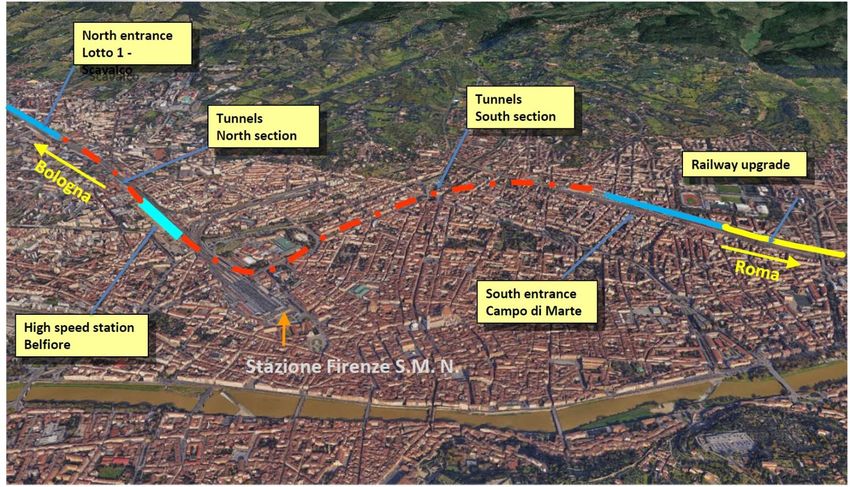
3.3. The High Speed Rail Link
High speed rail lines have been constructed north from Bologna and south from Rome,
but since Florence Santa Maria Novella station (1848; replaced 1934) is a terminus,
through trains must currently enter facing in one direction and leave in the other. The
proposal is for a pair of tunnels between these two sections, to make a continuous through
route (Fig 3). The tunnel portal has been formed on the south, and the box of a new
subterranean station to the north-west of Santa Maria Novella Station is in course of
construction, to link to the northern line, much of which is in tunnel. The transport
advantages of the project are seen as:
Reducing transit time by about 10 minutes;
12 Separating the high-speed line from local services, freeing capacity in Florence
Santa Maria Novella station for improved local and suburban services. Some
59million passengers per annum use the existing station;10
Local works to help facilitate the city tram system (see below).
The southern portal and the new station (designed by Foster + Partners) are both outside
the World Heritage property, alongside existing railway lines. Although in the buffer zone,
neither involve structures that would materially affect the setting of the property, nor do
they raise archaeological issues. The physical impact of the project on the property is thus
limited to boring twin tunnels beneath the two southern bastions of the Fortezza da Basso,
then eastwards under the Viale Lavagnini (one of the avenues created after demolition of
the city wall by Giuseppe Poggi, 1865-71), continuing through and beyond the Piazza della
Libertà, under the triumphal arch (Arco dei Lorena, 1738).
The tunnels will pass mostly through clay and gravel laucastrine deposits, the crowns about
13-15m (fortress) or 20m (arch) below the foundations of the monumental structures.
Tunnelling through plastic deposits inevitably results in a small volume loss (predicted to
be 0.4%-1%) and thus some subsidence. This would be expected to result in ‘very slight’
damage (fine cracks), or for part of the Fortezza, ‘slight’ damage, unless mitigation
measures are undertaken. Compensation grouting is therefore proposed beneath the
bastions of the Fortezza (Fig 4). Maximum settlement under the Arco dei Lorena (a free-
standing structure) is anticipated to be 10mm. The effects of the works will be monitored
using multiple measuring techniques.
The mission concluded that the proposals have been subject to intensive expert scrutiny
by the authorities. Permits were first issued for these works in 1999, but these having
expired, fresh applications were made in 2013, and new permits issued in March 2016.
While the Mission members are not civil engineers, on the evidence we saw both the
route and the precautions to be taken appear to have reduced the risk of harm to the
fabric of the monuments to a very low and acceptable level.
3.4. Mobility in the historic centre and the developing tram system
Context
The development of a tram network is part of an on-going-term strategy to modernise
the city’s transport infrastructure. The compact, dense character of Florence provides the
conditions ideal to support intensive public transport, and the problems of CO2 emission,
air pollution and congestion have provided the imperative to shift towards sustainable
ways of moving around the city. Change is inevitably incremental, for it depends on both
substantial investment and maintaining public support; but progress in recent years has
been impressive.
One tram line opened in 2010 and two more (including an airport connection) are due to
open in 2018, part of a developing system (with suburban rail improvements) intended to
10
http://www.grandistazioni.it/cms/v/index.jsp?vgnextoid=84db47db3c09a110VgnVCM1000003f16f90aRCRD
13move people easily and sustainably to, from and around the historic centre. This is
essential if the centre is to be easily accessible from the wider area and so able to support
the wide range of functions appropriate to a regional capital, as well as visitors. Within
the centre, pedestrianised areas have grown from 260,000 m2 in 2009 to 400,000 m2 in
2016, including the Piazza del Duomo. There are dedicated cycle paths; cycling is already
popular, with a public bike-sharing scheme being introduced in 2018, initially with 50
stations. About a third of the taxi fleet is currently electric or hybrid; by 2020 all of it must
be. Mini-electric buses have been introduced within the World Heritage property. The
mission experienced both in action; their only disadvantage is silent operation, with the
need (because of the novelty of this) for audible warning in shared-surface streets.
Daytime private car use in the historic centre is strictly controlled through a limited traffic
zone (LTZ) with 24 gates; entry is mostly limited to residents. There is automatic entrance
surveillance and eco road pricing; but also a traffic control room and remotely managed
traffic lights to minimise congestion outside the LTZ and the pollution it brings. As the
tram system develops the LTZ can be expanded to include more of the metropolitan area.
The strategic tram network
The historic centre north of the Arno is now defined by wide tree-lined avenues, the Viali
di Circonvallazione laid out in 1865-71 by Giuseppe Poggi, following the demolition of the
city walls. The Viali continue to be the major vehicle circulation route around the city
centre, and in the early 20th century there were trams running down the centre of the
avenues. The strategy for the new tram system, once it is fully developed, can be
summarised as bringing trams back to the avenues, with spur lines radiating outwards to
the suburbs and ‘park + ride’ facilities, and eventually to neighbouring municipalities. The
arc along the boulevards loops inwards around Santa Maria Novella station, reinforcing
the role of the piazza in front of the station as the public transport hub of the city (Figs 5,
6). Line 1 to Scandicci, in operation since 2010, now carries 13m passengers per annum.
Line 2 (to the airport) and Line 3.1 (to Careggi) are under construction. Line 4 will
continue the line along the north-west avenue to the Piazza della Libertà, with a loop into
the city through Piazza San Marco. One arm of line 7 will eventually complete the
boulevard route on the east side, to the Ponte San Niccolo, before turning east along the
Arno.
The choice of routes for tram lines is limited both by the physical constraints of the urban
fabric and the character and uses of spaces through which, in purely engineering terms, it
would be possible to route them. The avenues provide an easy route around the historic
centre on the north side of the river, but bringing lines into the centre is much more
problematic, other than the loop into the Piazza della Stazione, that area having taken on
its present, relatively open, form in the 1930s. The perception is that to make an effective
modal shift from the large numbers of motor buses that currently operate within the city,
trams (and potentially a metro line) need to offer access to other points across the city.
Switching to clean fuel would eliminate pollution, but not their vibrations adjacent to
historic buildings, nor their negative impact on pedestrian and cyclist experience of using
the historic streets.
14The initial proposal to bring trams beyond the Piazza della Stazione was to extend line 1
through the Piazza Duomo, then north along the Via Cavour to the Piazza della Libertà
(Fig 7). The current proposal (part of the next phase of tramway construction) is for a
spur south through Piazza San Marco, using two adjacent streets to form a loop from the
boulevard at the Piazza della Libertà (line 4). This would bring much more of the historic
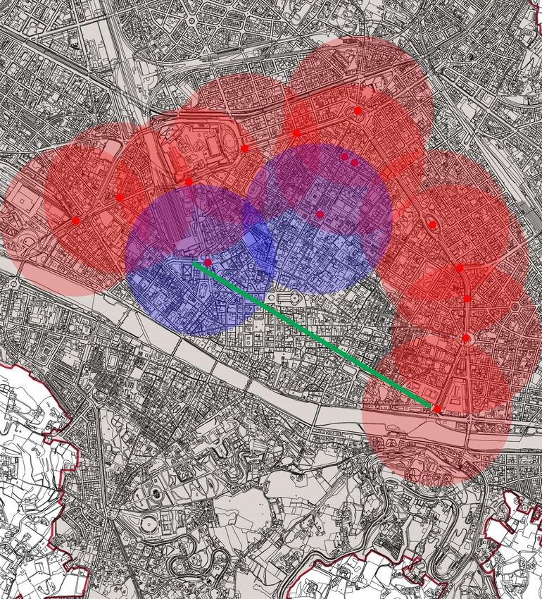
centre within 500m of a tram stop11 (Fig 9), while avoiding some of its most heavily
frequented streets and squares.
The mission concluded that this is the preferable option, maintaining the gains of
pedestrianisation by bringing trams relatively close to the Piazza Duomo rather than into
or through it. Given the current dominance of buses in the Piazza San Marco, it would
represent an improvement on the present environment of the square.
A possible underground metro link?
The completion of the present plan for the tram network, including Line 7, would still
leave the area centred on the Piazza della Signoria 900 to 1000m from a tram stop (Fig 9).
Presumably for this reason, and to provide rapid access from the railway stations direct
to the centre, an underground metro line has been suggested from the stations to the
proposed tram stop at the Piazza Piave, at the south-east corner of the northern part of
the historic city. Such a link does not form part of the current (2014 revision) Structure
Plan for the city and has therefore not been further considered by the current Mission.
The mission recommended that while closing the tram loop through an area where trams
cannot reasonably run seems logical, the risks from subsidence of boring shallow tunnels
through the soft, wet deposits of the Arno valley, right under the heart of the city and its
monuments, are quite simply too great. Moreover, constructing the stations would be
highly disruptive at best (if they could be located in open squares) or destructive at worst
(if demolition was needed), and the archaeological consequences would be substantial.
This is an idea which has been floated for some years, but in the Mission’s view should
now be decisively abandoned. Instead, if, as the system develops, there is a clear need to
improve coverage, the potential of a spur from the east, following the precedent of those
from the west and north, might perhaps be explored (Fig 9). However, most visitors enter
the city from the west; with local electric mini-buses and the wider use of cycling and
walking, the need for even coverage may be more apparent than real, while the possible
advantage of speed could be lost in the process of descending and ascending. Moreover,
a means of delivering large numbers of visitors arriving by high speed train or from a
suburban park + ride directly into the heart of the city sits uncomfortably with the
objective of dispersing visitors more widely (see 3.9).
The impact of the tramways
The Mission was able to see Line 1 in operation (Fig 8) and parts of Line 3 in an advanced
stage of construction, as well as engineering drawings of the imminent works. Technical
improvements will be incorporated from line 2 onwards to minimise noise from wheel to
rail contact, and in sensitive areas (including the San Marco loop) to minimise transmission
of vibration. Line 3 (Fig 6) begins in front of the railway station, follows the existing street
11
An arbitrary figure but roughly the distance between the Piazza della Stazione and the Piazza Duomo
15around its north-east flank, to turn across the south-east front of the Fortezza da Basso,
and then northwards around the boundary of a small park, part of Poggi’s improvements,
which borders the fortress on the north-east. In front of the fortress the tramway will
pass across an existing piazza (Beslan-Fortezza) formed on top of an existing underpass
on the line of Poggi’s boulevard, which here cuts between the fortress and the city, before
following the boundary of the park and continuing over the street, the latter sunk into an
underpass to facilitate the crossing. This is not an easy area into which to fit a tramway,
but it is being achieved with little impact on the existing built fabric. The only alteration is
that the west boundary wall of the late 19th century villa12 opposite the fortress, already
partly altered to accommodate a previous traffic scheme, will be set back.
Line 4 (Fig 7) will pass through more sensitive areas, both in the Piazza della Libertà and
in the loop through relatively narrow streets to the Piazza San Marco, along the Via
Cavour and returning along the Via La Pira. The masts supporting the contact wires
(where cables cannot be strung between buildings) are lightweight and relatively
unobtrusive – the effect can be judged from the existing line 1. There will be no stop in
the Piazza San Marco; instead stops are located in the flanking streets (Fig 10). In passing
around the Piazza della Libertà the tram will stop outside the triumphal arch, the Arco
dei Lorena (Fig 11). This is not ideal, but the short sides of the square are too short to
locate a stop there. In any case passing motor traffic means that the views are and will
continue to be very rarely uninterrupted.
The Mission concluded that while construction work around the station (Fig 12) is
causing some temporary disruption (and revealing some superficial archaeology),13 great
care has been taken in planning the route. The ongoing construction of line 3 will not
cause material harm to the Outstanding Universal Value of the property. The construction
of the tramways is seen as an opportunity to improve and enlarge pedestrian connections
and spaces, and ‘to characterise the tramway itself as an important part of the urban
quality’, through the design and materials used. Line 4 is less complicated, entirely following
existing streets, and every effort has been made to minimise the associated infrastructure.
Its impact on the street environment promises to be a significant improvement over the
existing heavy bus traffic, which physically it will displace. On that basis, given that it is a
reversible intervention,14 and notwithstanding the importance of the former Dominican
convent of San Marco (and the Arco dei Lorena), the balance of advantage lies clearly in
its construction.
3.5. Parking in the historic centre
The Piazza Pitti has been cleared of parked cars and reclaimed for public use, as has the
majority of the Nuova Piazza del Carmine (Fig 13). After extensive research, study and
consultation, the traditional stone paving of the latter is to be repaired (Fig 14) and trees
re-introduced on the side opposite the Carmelite church. A private sector initiative to
12
Since 1964 the Pallacongressi, formerly the Villa Vittoria by Gerolamo Passeri, a pupil of Giuseppe Poggi; built
1886-91, raised 1925; its landscape garden is part of Poggi’s urban plan
13
Related mostly to buildings demolished in the 20th century to create the piazza
14
Save for any shallow archaeology (most likely earlier street surfaces) which will be displaced by the track bed
16create a car park under the piazza has been rejected; it would not only have changed the
historic fabric and character of the place, but perhaps more importantly, would have
encouraged the presence and passage of cars in the southern part of the historic centre.
These are important and highly visible examples of the city having adopted a progressive
approach to reducing car use, both to reach the city centre and particularly to circulate
and stop within it. Priority continues to shift from cars to ‘soft mobility’ (walking, cycling)
supported by (electrified) public transport. This trend is, inevitably, closely linked to
attitudes to and provision for car parking within the historic city. The City’s strategy is
that cars approaching the historic city from the surrounding area will use park + ride
facilities and then suburban trains/ trams.15 The limited provision in existing underground
car parks off the perimeter ring road could provide for priority users and some city centre
residents, allowing parking in the historic centre to be further reduced. There are some
private commercial car parks within the historic centre, outside direct control of the city
authorities, but they are mostly small, old and poorly structured, squeezed into corners
of the historic urban fabric. Spaces in them should tend to decline, as tolls increase and
other, more valuable, uses for the sites and buildings become commercially more
attractive, in line with trends in other historic metropolitan centres.
The 2015 Town Planning Regulations, Article 41, identifies 21 potential locations for
private parking beneath streets and squares in the city ‘as services to the residents and to
economic activities’. Six of these are just inside or just outside the World Heritage
property (Fig 26), on or easily accessed from the Viali di Circonvallazione. If these are
brought forward (no concessions have yet been granted), spaces could only be purchased
by owners of real estate within 500m of the car park, with at least 70% reserved for
owners of residential units.16 All are anticipated as being of modest size, accessed by car
lifts rather than ramps; proposals will be judged on design quality in context and subject
to feasibility studies integrated with Heritage Impact Assessment,17which should comply
with published ICOMOS guidance.18
These policies and trends provide the background against which to assess a proposal to
create a 190-space car park on two levels beneath the Piazza Brunelleschi and through the
redevelopment of an adjacent redundant university laboratory (Fig 15). The piazza,
currently used partly for parking, to the detriment particularly of the Rotonda del
Brunelleschi,19 would be restored as a public space, although with a prominent two-lane
exit ramp on the west side. The laboratory, constructed in the mid-20th century in a
‘Florence vernacular’ style (Fig 16), is arguably neutral in its contribution to Outstanding
Universal Value, is unlikely to be of social value to residents, and is one of the few buildings
in the historic core whose replacement might reasonably be contemplated. The
15
Regolamento Urbanistico, 3.3, on mobility
16
The terms are governed by Municipal Regulations made in Deliberation 43/2016, under powers granted by
Law 122/89
17
We are grateful for a paper forwarded by Carlo Francini on 4 July 2017 clarifying the situation
18
Heritage Impact Assessments for Cultural World Heritage Properties: A publication of the International Council on
Monuments and Sites (January 2011)
19
An innovative octagonal church begun by Brunelleschi in 1433-34; later additions removed and completed in
‘stripped classical’ form in 1936-37. It is now part of the University of Florence.
17promotors, the Bufalini Estate, envisage the car park as largely serving the University and
the nearby Santa Maria Nuova Hospital. Vehicles travelling to it would only be able to
enter the limited traffic zone (LTZ) from the ring road if a place was pre-booked, and
would follow a prescribed route from the ‘gate’ (Fig 17).
The Mission concluded that subject to technical construction issues being resolved,
particularly potential effects on the water table, and to the replacement building being of
high architectural quality, well related to its context, the physical implementation of such
a project might be achieved with limited harm to the significance of the Piazza and the
Outstanding Universal Value of the property. The unavoidable impact would be the
prominent exit ramp, prominently placed in the centre of one side of the square. But
however well access is managed, the construction of a substantial car parking facility only
three blocks north-east of the Duomo,20 and whose access route would be within one
block of the Duomo, would run wholly counter to the now well-established policy of
steadily reducing the circulation of cars within the historic centre. While the proposed
access route to a car park in this location near the centre may not seem so exceptional
now, the trend of current policy suggests that it will be seen as intrusive a few years hence.
Yet given the financial investment that would be involved in creating the car park, once
approved and constructed its ongoing use could not reasonably be restricted or ended
without substantial compensation. Looking ahead, the private asset would likely become
a public liability, one that would not readily adapt to any other purpose, unlike the small
private car parks that exist in the city.
As a general principle, the mission concluded that creating car parks in the historic
centre accessed other than almost directly from the Viali di Circonvallazione should be firmly
resisted, in line with City policy, despite the special pleading that will inevitably be
associated with every proposal. Mapping this proposal in relation to potential car parks
sites intended primarily to serve residents, identified under Art. 41 of the Town Planning
Regulations (as we have done on Fig 26), illustrates very clearly the degree to which it is
contrary to the objectives of current policy to improve the environment of the city.
3.6. Waste Management
The ‘hyper-use’ of the historic centre generates large quantities of refuse, from residents,
businesses, and tourists. Few of the historic buildings have internal storage for waste
beyond what is generated day to day; the lack of ground level space means that bulky and
unsightly waste containers on the streets are intrusive, and incompatible with the decorum
of the historic city; in the summer food waste rapidly becomes unhygienic; and the
environmental (and financial) imperative to recycle now requires multiple bins to separate
different streams of waste. The problem is the concentration of waste, 15kg per 10 metres
of street every day.
To address these problems the City is installing, as a public utility, a network of 5m3
underground waste containers, which are emptied by a contractor (Alia Spa) which also
acts as technical consultant and installs the infrastructure (Fig 18). The tops of the
containers are flush with the pavement, with an upstanding hatch through which waste is
20
Within the line of the 12th century walls
18deposited. They are installed in groups, with separate containers for the different types of
waste. These are used by residents, businesses and tourists alike, so there is no need for
conventional litter bins which tend rapidly to overflow. They are emptied (rapidly) by
compactor vehicles capable of lifting both underground and surface containers. To date
45 have been installed, with 46 more to be installed by 2020 to achieve complete coverage
of the historic centre.
The Mission concluded that the containers represent a very significant improvement
over the previous (and standard) approach of surface level bins, as part of an efficient
strategy of public realm management which helps keep the city notably free of litter and
rubbish. They are as neat and as unobtrusive as their function permits (Fig 19), and their
impact on the streetscape, the setting of the city’s buildings, is readily reversible should a
better approach (or the quantities of rubbish) diminish in the future.
The only irreversible impact on the cultural value of the city lies in the need to construct
concrete-walled pits around 3m deep to house the containers, in an area of all of which is
potentially of archaeological significance. But through collaboration with the
Soprintendenza Archeologia, Belli arti e Paesaggio, the works are being treated as, in effect, a
programme of archaeological test excavations, which is already enriching understanding
of the evolution of the city and its buildings. The small loss of archaeological deposits is at
least balanced, if not outweighed, by the knowledge gained. Since the Soprintendenza must
give consent for the progress of the work, there is little risk of exceptional structural
discoveries being destroyed.
3.7. Re-use of public buildings in the Historic Centre
Introduction
Both the national government and, particularly, the City Council, are major landowners
within the city, of cultural sites, operational buildings, and in the case of the City, of social
housing and other public infrastructure. Operational needs change over time, so there is
an inevitable ‘churn’ of buildings falling vacant and needing new or reinvigorated uses,
whether by public authorities, charitable foundations or the private sector. Change of this
kind is an indicator of a living, thriving city. It presents a threat to its Outstanding Universal
Value only if buildings deteriorate through being left vacant or under-used (and in
consequence usually minimally maintained) for lengthy periods, or the proposed new uses
would require intervention on a scale that would materially harm their cultural heritage
values, including their social values to the community.
The City aims to ‘enhance and utilise all the municipal buildings…in the historic centre,
privileging public functions’ both to save the cost of renting offices and avoid degradation
through under-utilisation or abandonment. Under the Structure Plan about 250,000m2 of
disused buildings are proposed for ‘transformation’ to new uses. This policy extends to
the acquisition of property both within and beyond the historic centre, to preserve its
cultural value, public access, and to house public offices. Disposals of monumental
complexes are normally by way of a lease or agreement requiring investment in
19safeguarding the fabric and guarantees of public access through the uses proposed. There
is a strong policy to retain and expand housing within the historic centre, despite
commercial pressure for (and the value of) uses related to tourism.
A case study: the relocation of the Law Courts
The relocation of the law courts from the historic centre to a new Palazzo di Giustizia
outside it, on the former Fiat site, completed in 2012,21 meant that possession of several
buildings in the historic centre reverted to the City. The City administration is based in
the Palazzo Vecchio, and in 2013 adapted two of these buildings, close to the Palazzo, one
for its Property Management Department,22 the other for the headquarters of the Urban
Planning Department (Fig 20),23 which relocated from late 20th century rented offices
outside the centre. These moves are part of a general policy not only of retaining
Comunale offices in the historic centre but also actively relocating departments there, 24
helping to sustain one of its core city functions. There are now some 860 City office staff25
located in the historic centre. The Mission visited the Urban Planning Department, whose
director was firmly of the view that as a working environment it was preferable to the
standard recent office building they had formerly occupied, despite some inherent
constraints.
The former headquarters of the courts was in the San Firenze monumental complex, a
seminary of the Oratorians which developed through the late 17th and 18th centuries,
culminating in the coherent baroque façade that now dominates the Piazza San Firenze
(Fig 21). The former Oratory itself is in the south block and a church (still in use) in the
north block, with the former residential accommodation around a courtyard between
them. The ground and first floors (save for the church) have been assigned to the Zeffirelli
Foundation for 29 years, as a museum and school of the performing arts, based on Franco
Zeffirelli’s collections including his library. It was a condition that the roof covering of the
whole complex be renewed at the outset, the need for which was clear from the stains of
leaks from the parapet gutter into the plain vaulted upper rooms (Fig 22) during the period
of disuse (2012-17). The Oratory itself, a fine galleried hall, will continue to be used for
performances, and the Foundation is in negotiation to take over the remaining upper
floors for related educational activities. The Mission saw fitting out in progress; in the
exhibition rooms on the first floor, displays will be on a continuous panel lining, with all
the services contained within them, making the fit-out readily reversible and adaptable.
The mission concluded that the City’s action, after the removal of the Courts, has
secured appropriate new uses for the vacated buildings, setting an example in bringing
their own staff into historic buildings in the centre, while securing investment in and a new
public-facing use for a monumental building on terms in which the City retains the long-
21
The building, originally designed by Leonardo Ricci in the 1970s, makes a distinctive, jagged contribution to
the city skyline (in the buffer zone), on which local opinion seems to be divided; but as a major public building
it is appropriate that its place in the hierarchy of the city should be expressed by rising above the general
roofscape
22
Via dell’Anguillara 21
23
Piazza San Martino, a former convent
24
Including into a former University building (2013) and two former schools (2016)
25
Of which 370 are based in the Palazzo Vecchio and Palazzo Canacci
20term interest in the building. However, the museum element will add to the existing
concentration of attractions in an already heavily visited area (see 3.9).
Other city projects
The City has built a new opera house on the ring road on the west side of the historic
centre (a theatre is in progress as a second phase) and in consequence the former Teatro
Communale26 has been sold for mixed use conversion; work is expected to begin this
year. Towards the edges of the historic centre, especially in the east, and in the area south
of the Arno, the municipality makes available small buildings on modest terms to
accommodate social and cultural associations.
The Fortezza da Basso, until the 20th century a military site, was purchased in 2009 from
the state by the Tuscany Region, the Metropolitan City of Florence and the City of
Florence, as an exhibition centre, adjacent to the existing conference centre. In 2016 the
City acquired from the state the redundant Carabinieri school, including what was
historically the main cloister of the Dominican Priory of Santa Maria Novella. The cloister
buildings (seen by the Mission) will be opened as an extension to the Santa Maria Novella
museum, while commercial proposals are being sought to develop the rest as an
innovation centre.
In the east of the historic centre, where few tourists venture, the University of Florence
has set up a School of Architecture in the abandoned Santa Verdiana and Santa Teresa
detention complex; the former is in use, preliminary works are in hand on the latter (Fig
23). Not far away the Murate prison, closed in 1983, was converted (2000-11) into social
housing (73 units), public, cultural and commercial space; the remaining buildings are
currently being converted into a further 17 units. Architecturally and socially the spaces
are successful (Fig 24).27 Only now does the future of the former the Sant'Orsola convent,
later a tobacco factory (1810-1940), seem to be moving towards an appropriate resolution
after 30 years of indecision and an abandoned project.28 Identifying and implementing new
uses for these buildings has taken much longer than was desirable for the good of the
fabric (perhaps because of their previous uses and associations), but recent redundancies
of public buildings, like the former court buildings, have been addressed much more
quickly.29
3.8. The Management Plan and Heritage Impact Assessment
In January 2016, the City Council adopted a new Management Plan for the Historic Centre
of Florence, produced following wide community consultation (2013-15), and including the
Buffer Zone approved in July 2015.30 The plan aims ‘not only to preserve but to enhance
26
Although originating in the 1860s it has been greatly altered, most recently in 1961
27
Both seen by one of us (PD) after the end of the mission
28
A project put forward by a private sector consortium, and which has the support of the Municipality, is
currently being considered by the Soprintendenza Archeologia, Belli arti e Paesaggio and will be subject to public
consultation by 10 August (Information from Carlo Francini, e-mail 26 June 2017)
29
For further discussion of buildings in need of new uses see Section 4.2 below
30
39 COM 8B.44
21You can also read