Journal of the Social Sciences
←
→
Page content transcription
If your browser does not render page correctly, please read the page content below
Journal of the Social Sciences                                    January 2020 Volume 48 Number 1

        Journal of the Social Sciences
                                               J

                          E-ISSN: 0975-8935 P-ISSN: 0253-1097

                          Cosmos Impact Factor: 6.120 (2019)
                                 Journal of the Social Sciences

                                        www.apcjss.com

                                              19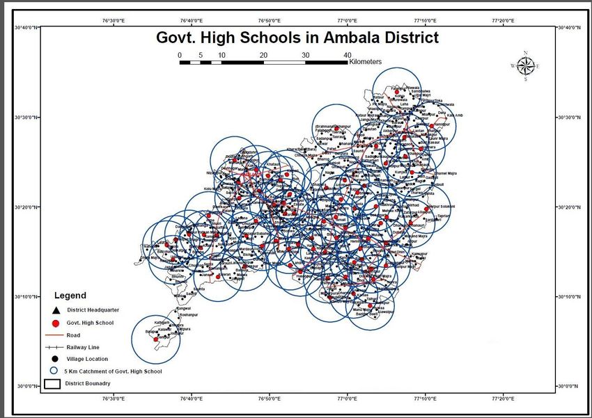
Journal of the Social Sciences                                              January 2020 Volume 48 Number 1

  Application of Geospatial Technology to the school mapping in District
                             Ambala, Haryana
                               Sandeep Kumar1,Sadanand2, Rajesh Moond3
                                              Project Assistant
                          Haryana Space Applications Centre, CCS HAU Campus Hisar

Abstract

Geospatial technology is a collection of tools and techniques that work on geographic information system data
and is used in analysis and education is an important part of any civil society. Education is an important part of
any civil society. Proper educational facilities generate high quality human resources for any nation. Therefore,
the government needs a skilled and better citizen who can help in analyzing the current state of education and
its progress.
The government also needs a system that can aid decision making and policy making. GIS technology can fulfill
the requirements mentioned not only for the government, but also for the general public. To meet the standards
of human development, it is very important for the government and decision makers to keep a close watch on the
current education policy and the status of its implementation. School mapping involves the creation of a
geospatial database of schools that aids in infrastructure development, policy analysis, and decision making. The
current research work is an attempt to support the Right to Education (RTE) and Sarva Shiksha Abhiyan (SSA)
programs run by the Government of India through the use of GIS.

             Key word: 1.School Mapping, 2.Catchment, 3.GIS, 4.GPS, 5.Sarva Shaksharta Abhiyan.

1.Introduction-

Education is an important part of any civilized society. Proper education facilities generate high quality and
best human resources for any nation. Therefore, the government needs an efficient system that can help
analyze the current state of education and its progress. It also requires a system that can aid decision making
and policy making. Geographical Information System (GIS) can fulfill the requirements mentioned not only for
the government, but also for the general public.
GIS is a collection of techniques and tools that work on geospatial data and is used in analysis and decision
making. GIS technology is required for very diverse fields from government to general public, from vocational
to social service, from science to defense. analysis, output, and distribution of spatial data and information to
devise spatial data from the real world for a particular purpose Storing and Receiving Equipment for
Changing and Receiving”. GIS is a system that works on spatial as well as attribute data.
Today the location components of data become very important. During recent times, the availability of
location data has increased rapidly due to the growth in the field of remote sensing, global positioning system
(GPS), GPS enabled smart devices, etc., resulting in increased demand for GIS technology and web. GIS can
now refer to most people, facilities, and events by location.
This research work is a very important and commendable effort to support the Right to Education (RTE) and
Sarva Shiksha Abhiyan (SSA) program under the Government of India which is the Right to Free and
Compulsory Education (RTE) Act, 2009, Indian It was added to the constitution, which provides the child with
the obligation on the government to complete elementary education, admission, attendance and elementary
education of the child.
In order to meet the standards of human development, it is very important for the government and decision
makers to keep a close watch on the current education policy and the status of its implementation. This

                                                       20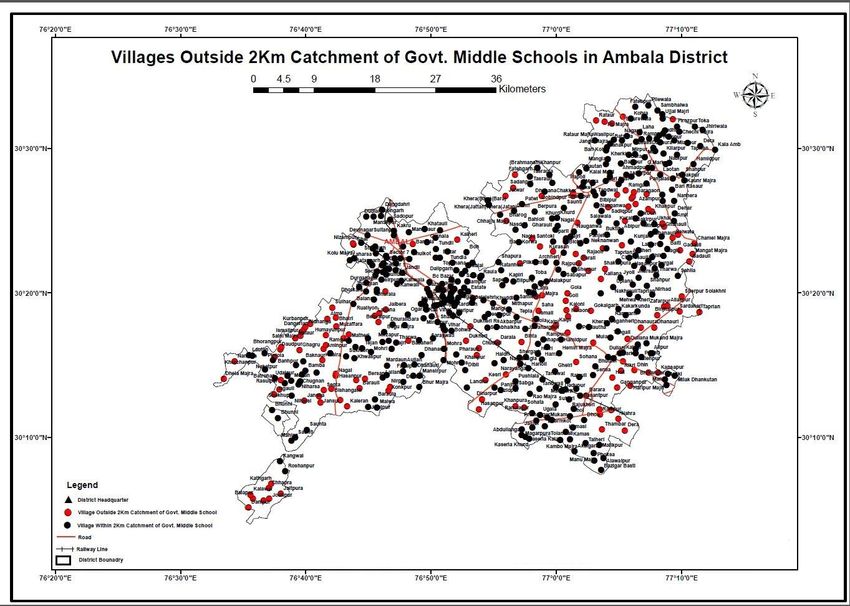
Journal of the Social Sciences                                             January 2020 Volume 48 Number 1

research work will be particularly helpful in assessing the success of any policy. In case of any discrepancies,
it will help to identify problem areas and can also help in finding remedial solutions to problems.

2.Study Area-

The Haryana is located in the northern part of India.It is divided into 22 districts.Ambala is one of the
important districts known for its educational and industrial significance. According to the administrative
division, Ambala district is sub divided into 4 community development block and 7 revenue tehsils.
Community development blocks are Ambala, Ambala cantt, Barrara, and Naraingarh. Tehsils are Ambala,
Ambala cantt, Barara, Mullana, Saha, Sahazadpur and Naraingarh, Literacy rate 87.46% and total in District
village 408.
District Ambala lies on the North-Eastern edge of Haryana between 27°39″45′N latitude and 74°33″53′E to
76°36″52′E longitude.

3. School Mapping-

School mapping is an important and special part of web GIS in the education sector. According to (Al-Hanabali
et al., 2005), "School mapping to build geospatial databases with relational databases of educational,
demographic, social and economic information from schools and educational directorates to support
educational planners and decision makers." There is art and science. ”So web GIS works as a visualization tool
and also helps in planning and decision making. It can be used in infrastructure development and upgrading
of schools by combining several indicators (Atfield et al., 2002). It provides tools and techniques that handle
education from a geographic perspective. At times, it helps executives when they need support to make
decisions such as:

Is a new school required?

• What should be the location of the new school?

• Is there an appropriate place for each student in the current school?

• What-if analysis?

How far is the school from the village?

Number of students available?

Number of teachers available?

In literature, some examples of school mapping can be found.discussed about the concept and development of
school mapping.

Another paper (S. Agrawal and R.D Gupta 2016 have shown the used GIS for education in the Jharsa
development block.

                                                      21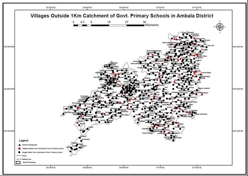
Journal of the Social Sciences                                             January 2020 Volume 48 Number 1

4. Data Collection-

In the present work, 289 schools have been taken in Ambala district for the school mapping which are
operational in 408 villages Following steps were taken for the collection of data.

Block               Govt. S.S. School     Middle                   High school            Primary school
Ambala-I (City)     20                    15                       27
Ambala-II (Cantt)   17                    8                        25
Barara              16                    15                       19
Naraingarh          16                    6                        29                     478
Saha                10                    14                       17
Sehzadpur           12                    5                        18
 Source-Haryana School Education Department.

4.1 Village Boundary Map-
Village boundary of Ambala District has been taken from Haryana Space Applications Centre, Haryana
Government of Haryana. It is used for prepetition of village boundary map through georeferencing and on-
screen digitization. Total 408 village boundaries have been digitized. An attribute table was built that consist
of village name, code etc.

4.2 GPS field survey
The location of each school of Ambala District has been collected using the hand held GPS. Trimble handheld
GPS with 2-5 meter real time accuracy has been used for this purpose. Some point take googles earth location
There are 289 major schools and primary school 478 in Ambala District. Field survey using GPS has been
done to collect the location of all these schools. This data was later downloaded on the computer and then
converted latitude and longitude into the point shapefile.

4.3 Attribute Data Collection
The school data in the school mapping research work has been taken from the Department of Education,
Government of Haryana and the Boundary of the village and district has been obtained from the toposheet by
Digitization.

5. Geospatial analysis of data
In this research work, the geographic Information System has been used under which geospatial analysis is
done on the data collected in this research work. Data was collected by GPS and converted to point size and
display the boundary of the district. And various spatial utility maps have been created, the results of the
analysis are shown as maps. The datum for these maps is WGS 84 and the projection system UTM Zone 43N.

5.1GovtSenior Secondary School within 5 km radius
In this map, the government senior secondary schools in Ambala district, which fall within 5 km distance,
show the villages that show how many government senior secondary schools are available in the villages
within 5 kilometers, It is very important for the students studying, through this map, information about the
school within 5 kilometers is available. With which he can easily choose the nearest school.

                                                      22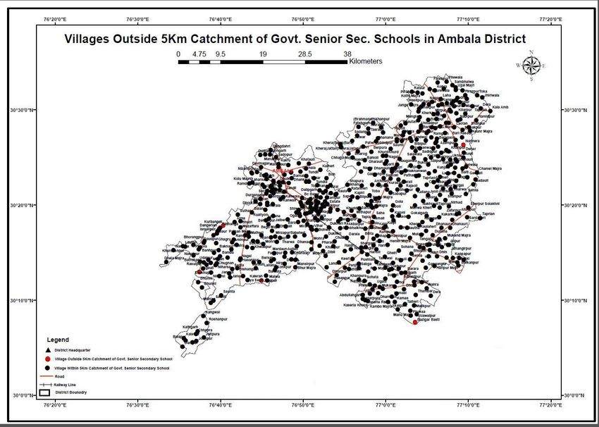
Journal of the Social Sciences                                             January 2020 Volume 48 Number 1

                          Figure.1Govt Senior Secondary School within 5 km radius

5.2 GovtSenior Secondary School outside the 5 km radius
In this map, the government senior secondary schools in Ambala district, which come outside the 5 km
distance, show the villages that show how many government senior secondary schools are available outside
the 5 km in the villages, which are available there. It is very important for the students studying, through this
map, information about the school outside 5 kilometers is available. With which he can easily choose the
nearest school.

                                                       23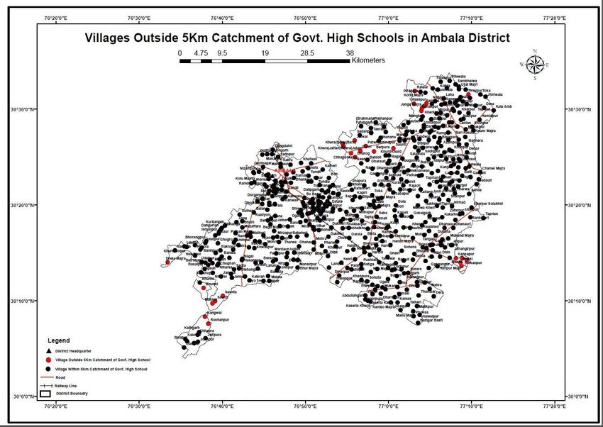
Journal of the Social Sciences                                                January 2020 Volume 48 Number 1

                        Figure.2 Govt Senior Secondary School outside the 5 km radius

5.3 High School within 5 km radius-
In this map, government high schools in Ambala district, which fall in 5 km radius are shown, which shows
that the availability of schools within 5 km in the villages, for the education and institutions of the district and
the people there. Is very important and necessary.

                                                        24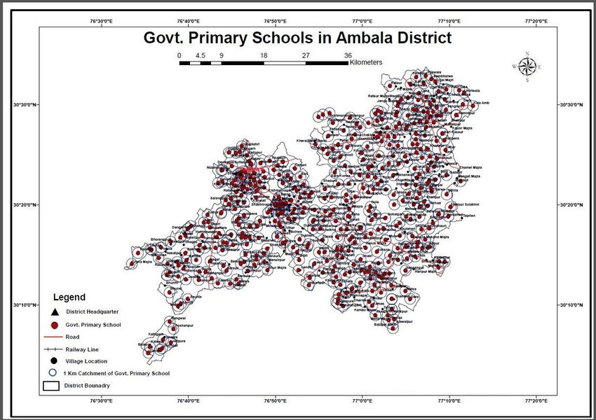
Journal of the Social Sciences                                            January 2020 Volume 48 Number 1

                                Figure.3 Govt High School within 5 km radius

5.4Govt High School outside the 5 km radius-
This map shows the government high schools in Ambala district which fall outside the 5 km radius, which
shows that the availability of the school outside the 5 km in the villages, which in the coming time there will
be new It can be helpful in opening schools and advancing academic work.

                                                      25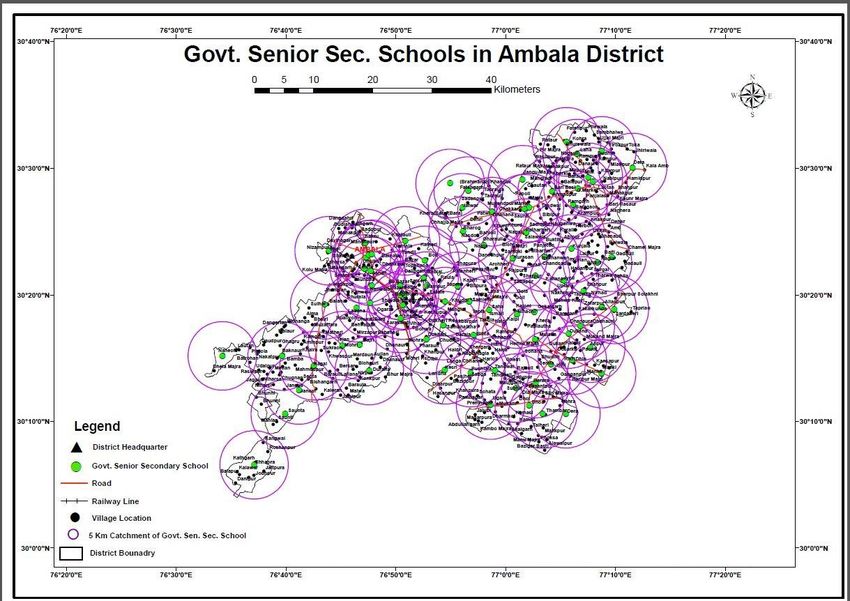
Journal of the Social Sciences January 2020 Volume 48 Number 1
Figure.4 Govt High School outside the 5 km radius
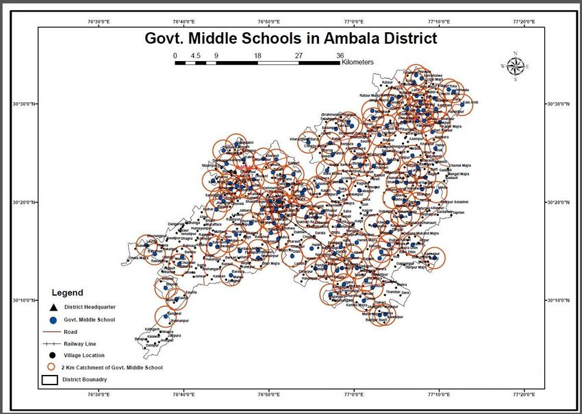
5.5Govt Middle School within 2km radius
In this map, the government middle schools in Ambala district, which fall within 2 km distance, show the
villages that show how many schools are available in the villages within 2 km, which is very much for the
students studying there. It is important to get information about the school within 2 kilometers through this
map.
26
Journal of the Social Sciences                                            January 2020 Volume 48 Number 1

                               Figure.5 Govt Middle School within 2km radius

5.6Govt Middle School outside the 2km radius
This map shows the government middle schools in Ambala district which fall outside the 2 km radius, which
shows that the availability of the school outside the 2 km in the villages, which in the coming time there will
be new It can be helpful in opening schools and advancing academic work.

                                                      27
Journal of the Social Sciences                                            January 2020 Volume 48 Number 1

                             Figure.6 Govt Middle School outside the 2km radius

5.7 Primary School within 1km radius
In this map, the government primary schools of Ambala district which fall within 1-kilometer distance, shows
the villages that show how many primary schools are available within 1 kilometer in the villages, which are
available for the students studying there. It is very important to get information about the school within 1 km
through this map. With which he can easily choose the nearest school.

                                                      28
Journal of the Social Sciences January 2020 Volume 48 Number 1
Figure.7 Primary School within 1km radius
5.8 Primary School outside the1km radius
In this map, the government primary schools in Ambala district, which fall outside the distance of 1 km, show
the villages that show how many primary schools are available in the villages outside of 1 km, which are
available for the students studying there. It is very important to get information about the school outside 1
km from this map. With which he can easily choose the nearest school.
29Journal of the Social Sciences January 2020 Volume 48 Number 1
Figure.8 Primary School outside the1km radius
6. Conclusions
Geographic information technology has contributed a lot in the school mapping
GIS is creating the innovative ways for the analysts and decision makers to critically examine the various
range of social and economic problems. this paper illustrates how the GIS will be employed in accessing the
present state of education and also in locating the probable places of concern within the study area. the
assorted analyses are administered on the mapped schools. The possible concerns are raised together with
each kind of analysis. These issues must be tackled for better education system. This paper provides the
framework of the appliance of GIS within the education field, particularly, school mapping and their
geospatial analysis required for the success of Right to Education (RTE) and Sarv Sikha Abhiyaan (SSA)
programme of government of India.
30Journal of the Social Sciences January 2020 Volume 48 Number 1
References-
1. Agrawal, Gupta R. D. (2016). School Mapping And Geospatial Analysis Of The Schools In Jasra
Development Block Of India, The International Archives Of The Photogrammetry, Remote Sensing And
Spatial Information Sciences, Xli-B2, Isprs Congress, Prague, Czech Republic.
2. Mehrotra, S. 2012. The cost and financing of the right to education in India: Can we fill the financing
gap?International Journal of Educational Development, 32, pp. 65–71.
3. Govinda, R., 1999. Reaching the unreached through participatory planning: School mapping in Lok
Jumbish, India. UNESCO Publishing IIEP: Paris
4. Ministry of Human Resource Development, 2016. Right to Education, India,
5. Ambala District Website (ambala.gov.in)
6. School Education Department (www.schooleducationharyana.gov.in)
7. Haryana School Shiksha Pariyojna parishad (www.hsspp.in)
8. Adelokun Adedapo Solomon, Adewole Israel Boluwatise Obafemi Awolowo University, Ile-Ife, Nigeria,
Designing a School Map for Expanding Public Primary School in Osun State, Nigeria (2018-2022) US-
China Education Review B, July 2017, Vol.7, No.7, 329-344
9. Widaningrum, D.L., 2015. A GIS–Based Approach for Catchment Area Analysis of Convenience Store.
Procedia Computer Science, 72, pp.511-518.
10. Mendelsohn, J. M., 1996. Education planning and management and the use of geographic information
system. UNESCO Publishing IIEP: Paris
11. Mehrotra, S., 2012. The cost and financing of the right to education in India: Can we fill the financing
gap? International Journal of Educational Development, 32, pp. 65–71.
12. Burrough, P. A., 1986. Principles of geographical information systems for land resources assessment,
Clarendon Press, Oxford.
31You can also read