Land suitability analysis using geographic information system (GIS): a case study in Soppeng district
←
→
Page content transcription
If your browser does not render page correctly, please read the page content below

Journal of Physics: Conference Series

PAPER • OPEN ACCESS

Land suitability analysis using geographic information system (GIS): a
case study in Soppeng district
To cite this article: S Wahyuddin et al 2021 J. Phys.: Conf. Ser. 1918 042154

View the article online for updates and enhancements.

                               This content was downloaded from IP address 46.4.80.155 on 05/09/2021 at 06:41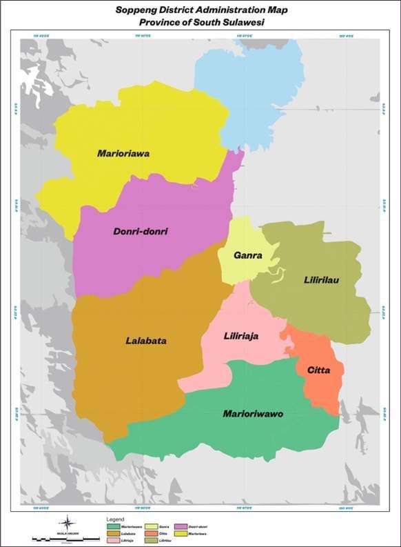
ICMSE 2020                                                                                                      IOP Publishing
Journal of Physics: Conference Series                         1918 (2021) 042154          doi:10.1088/1742-6596/1918/4/042154

Land suitability analysis using geographic information system
(GIS): a case study in Soppeng district

                     Wahyuddin S*, H Buchari, I I Wahab, Z Rahmat, and Z Fadli
                     Department of Informatics Management, AMIK Lamappapoleonro Soppeng, Indonesia
                     *
                         Corresponding author: wahyu@amiklps.ac.id

                     Abstract. The agricultural sector is a sector of the economy that is still the flagship in various
                     regions in Indonesia, especially Soppeng regency. The area of Soppeng hills is approximately
                     800 km2 and is at an average altitude of 200 m above sea level, and has no coastal area. The
                     utilization of Geographic Information Systems (GIS) promises resource management and
                     modeling, especially quantitative models, to be more accessible and simpler. GIS is an efficient
                     and effective way to know the characteristics of a region's land and its development potential.
                     Land suitability is the suitability of land for a particular purpose of use through the determination
                     of land value (class) and land use patterns connected to the territory's potential. It can be
                     attempted more targeted land use along with its sustainability maintenance efforts. The spatial
                     analysis involves modeling, testing, and interpreting model results to extract or form new
                     information from a collection of geographic elements. This research will be carried out for 12
                     Months (1 year) through 4 stages. The research aims to identify land use's suitability in the
                     analysis of agricultural land suitability using geographical information systems in Soppeng
                     regency area.

1. Introduction
Geographic Information System, abbreviated as GIS, is an information system designed to work with
spatially differentiated or geographically coordinated data. In other words, a GIS is a database system
with the special ability to handle spatially different data along with a set of working operations. Also,
GIS can combine data, organize data, and perform data analysis that will eventually produce output
referenced in decision-making on geography issues.
   Soppeng regency is one of the districts in South Sulawesi that has a large agricultural area. With
geographic information systems, people, companies, and government agencies can manage field data
more quickly and in detail. One of these services is the Department of Agriculture, Fisheries, and
Forestry of Soppeng Regency. The office has the main task of carrying out decentralized authority in
the field of agriculture in Soppeng Regency, agricultural data on both agricultural land and harvest
commodities so much in the field, so that the office desperately needs a Geographic Information System
for mapping agricultural land and commodity crops in Soppeng Regency. In addition to mapping
agricultural land and commodity crops, the office also records farmers' groups and farm landowners for
the distribution of government assistance[1].
   Determination of agricultural land should pay attention to the suitability of the land by its growing
requirements. To determine the choice of location is generally used a method of land suitability analysis.
According to Z. Maddahi [2], land evaluation or land suitability is an approach or way to assess a land
resource's potential. Land suitability classification in Indonesia and other developing countries currently
uses a land suitability classification system according to the FAO land evaluation framework of 1976

              Content from this work may be used under the terms of the Creative Commons Attribution 3.0 licence. Any further distribution
              of this work must maintain attribution to the author(s) and the title of the work, journal citation and DOI.
Published under licence by IOP Publishing Ltd                          1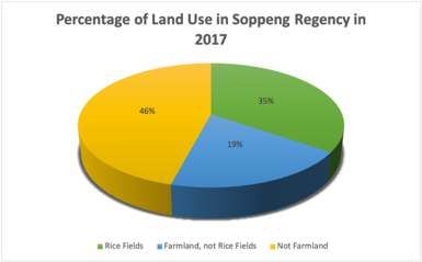
ICMSE 2020                                                                                  IOP Publishing
Journal of Physics: Conference Series           1918 (2021) 042154    doi:10.1088/1742-6596/1918/4/042154

[3]. Land use's success is heavily influenced by the fulfillment of requirements in land use[4]. Mistakes
in determining land use will affect the overall layout and have the potential to have a detrimental impact
on the environment and the economy[5].
    The benefits of this research can provide information to the public about the location of farmers
groups and agricultural superior commodity information in Soppeng Regency as well as as a
documentation facility for the Soppeng District Agriculture Office to know the location mapping and
superior commodity data handled in the service of farmers groups in Soppeng Regency.

2. Literature Review
Soppeng regency is dominated by agricultural land, both rice fields and not rice fields in 2017. The
agricultural land area in Soppeng amounted to 97,972 ha, while non-agricultural land amounted to
52,028 ha. The farmland consists of rice fields and farmland instead of rice fields. The area of
agricultural land in rice fields amounted to 29,081.8 ha or 19.39 percent of the total land area in Soppeng
Regency. While the area of agricultural land is not rice fields amounting to 68,890.2 ha or 45.93 percent
of the total land area in Soppeng Regency[6]. This can be seen in Figure 1 and Table 1.

(a)                                             (b)

Figure 1. (a) Percentage of land use in soppeng regency in 2017 (b) Rice fields in soppeng district in
2013-2017 (Ha).
              Table 1. Area of agricultural land by sub-district and type in soppeng district

                                   District        Fields     Addition      Summary
                       No                                      Fields
                     010     Marioriwawo         3,030.9      17,693.4      20,724.3
                     020     Lalabata            3,571.0      5,057.0       8,628.0
                     030     Liliriaja           4,371.9      4,816.1       9,188.0
                     031     Ganra               3,911.0      1,481.0       5,392.0
                     032     Citta                400.2       3,267.5       3,667.7
                     040     Lilirilau           2,121.9      15,626.1      17,748.0
                     050     Donri-Donri         4,615.0      16,240.0      20,855.0
                     060     Marioriawa          7,061.8      4,707.2       11,769.0
                                Total            29,083.7     68,888.3      97,972.0

    In Table 1 it can be seen that the largest rice field is in Marioriawa Sub-district of 7,061.8 hectares,
while the fewest is in the citta glasses of 400.2 hectares.
    From Figure 1b can see that every year the area of rice fields increases. The increase each year tends
to be stable, ranging from 1-2 percent from the previous year. The increase in rice fields every year is
due to the opening of new rice fields by the soppeng regency government in the last 5 years. The increase
in rice fields can undoubtedly support the strengthening of national food self-sufficiency and the welfare
of farmers, which is the priority of the development of soppeng regency[7].

                                                      2
ICMSE 2020 IOP Publishing
Journal of Physics: Conference Series 1918 (2021) 042154 doi:10.1088/1742-6596/1918/4/042154
3. Research Methodology
In agricultural surveys collected data on planting area or a number of trees, harvest area and productivity
per unit area or a number of production trees. As a complement, also collected mutation data such as the
area of the plant earlier in the month which according to the success rate, loss, and replacement of the
plant at the end of the month. Each plant is also asked about its intensification activities[8].
To monitor its success and obstacles, it also collected data on the extent of pest and disease attacks
and natural disasters. Its intensity measures each pest and disease attack. To assess the success of efforts
to increase productivity per hectare also collected data on superior seed fertilizers and types of irrigation.
Every beginning of the year also collected data on the area of rice fields and dry land according to its
use and reports of agricultural tools available and used[9][10].
The analysis method is a procedural analysis that aims to know more clearly how the system works
so that the system's advantages and disadvantages can be known. After conducting several analysis of
the problems faced, the design of the system development process was proposed on the solution built to
solve the problem and achieve the goals mentioned in the previous section[11].
Primary data collection through literature studies, interviews, and observations, software needs,
digitization of maps using ArcView/QGIS software. QGIS version 3.14 (formerly known as Quantum
GIS) is a desktop Geographic Information System (GIS) application that provides data display, editing,
and analysis. QGIS allows users to create maps with multiple layers[12][13]. After QGIS 3.14 software
is installed, the next stage is to build a database with MySQL, conducting system testing as the final
stage in analyzing agricultural land suitability using Geographic Information System (GIS) in Soppeng
Regency area[14]. Figure 2 shows the research flowchart.
Figure 2. Research flowchart
4. Result and Discussion
Increasing food production to support the strengthening of national food self-sufficiency is one of the
regional development priorities of Soppeng Regency by the region's potential. Therefore, land use for
food crops, especially rice, continues to be pursued by increasing irrigation efforts so that in one year it
can be planted several times.
3ICMSE 2020 IOP Publishing
Journal of Physics: Conference Series 1918 (2021) 042154 doi:10.1088/1742-6596/1918/4/042154
Table 2. Rice field area according to sub-district and realization of rice planting in a year in soppeng
regency in 2017 (Ha)
Realization in one year
Rice planting Not planted
District with rice
First Twice ≥ Three Planted by Not planted Sum
times other plants by other
plants
(1) (2) (3) (4) (5) (6) (7)
010 Marioriwawo 1.263,0 1.767,8 0,0 0,0 0,0 3.030,8
020 Lalabata 25,0 2.636,0 910,0 0,0 0,0 3.571,0
030 Liliriaja 0,0 4.342,0 18,0 10,0 0,0 4.370,0
031 Ganra 0,0 3.911,0 0,0 0,0 0,0 3.911,0
032 Citta 4,2 486,0 110,0 0,0 0,0 400,2
040 Lilirilau 1.103,7 1.005,0 0,0 13,3 0,0 2.122,0
050 Donri-Donri 275,0 4.340,0 0,0 0,0 0,0 4.615,0
060 Marioriawa 291,0 1.727,0 4.925,0 46,0 72,8 7.061,8
Total 2.961,9 20.014,8 5.963,0 69,3 72,8 29.081,8
In Table 2 it can be seen that the rice fields that have the realization of planting more or equal to 3
(three) times there in Marioriawa sub-district of 4,925 hectares, Citta sub-district of 110 hectares. While
other sub-districts did not experience the realization of planting three times or more.
In 2017 the largest irrigation rice fields area was in Marioriawa sub-district as 5,408 hectares, while
the fewest are in the glasses Citta as roughly 353.2 hectares. The largest rain-ed rice fields area is in
Marioriawa Sub-District of 1,635.7 hectares, and for Lalabata sub-district, which is at least 25 hectares.
The realization of rice planting in the rice fields of Marioriawa sub-district in 2017 can reach more than
three plantings. This happens in both irrigation fields and rain-covered rice fields. Descriptively it can
be stated that Marioriawa sub-district is the most likely sub-district to produce more agricultural
production compared to other sub-districts.
The area of land instead of the rice fields of Soppeng Regency tends to fluctuate. Over the past five
years, land is not the most widely used rice field as garden land. The land area instead of rice fields
began to be used a small part for the country's forests in 2015. The area of land used for the country's
forests continues to increase, reaching 19,602 hectares in 2017. The area of land, not rice fields from
2013 to 2017 has fluctuated before[7]. Figure 3 shows the Soppeng district administration map province
of South Sulawesi
4ICMSE 2020 IOP Publishing
Journal of Physics: Conference Series 1918 (2021) 042154 doi:10.1088/1742-6596/1918/4/042154
Figure 3. Soppeng district administration map province of South Sulawesi
5. Conclusion
The purpose of the research is to identify land use's suitability in the analysis of agricultural land
suitability using geographical information systems in Soppeng regency area. It concluded that QGIS
application is suitable for mapping the area of agricultural land in Soppeng district. From 2016 to 2017
there was a drastic reduction in the area of non-agricultural land. This is also in line with the increase in
the area of rice fields or non-rice fields in 2017. One of the efforts to increase the productivity of farmers
to come is by optimizing the government, resources and application of recommended technology
components in a location and efficient manner, it is expected that the increase in farmers' income
production, the expansion of employment opportunities, and the sustainability of the environment and
natural resources can be achieved.
Acknowledgment
I would like to sincerely thank Prof. Dr. H. Imran Ismail, M.S. as chairman of AMIK Lamappapoleonro
Soppeng foundation who has given full support and guidance so that this writing can be realized. As
well as not forgetting the special thanks I gave to the Ministry of Research and Technology/National
Research and Innovation Agency (Indonesia) for the research grant program of novice lecturers with
contract number: No. 7/E/KPT/2020.
5ICMSE 2020 IOP Publishing
Journal of Physics: Conference Series 1918 (2021) 042154 doi:10.1088/1742-6596/1918/4/042154
References
[1] Bhagat R M, Singh S, Sood C, Rana R S, et al 2009 J. Indian Soc. Remote Sens. 37 233
[2] Maddahi Z, Jalalian A, Zarkesh M M K & Honarjo N 2017 Soil Water Res. 12 29
[3] Harini R, Susilo B & Nurjani E 2015 Indones. J. Geogr. 47 171
[4] Kuria D N and Waithaka E 2011 J. Geogr. Reg. Plan. 4 525
[5] Subiyanto, Hermanto, Arief U M & Nafi A Y 2018 Heliyon 4 2045
[6] Malczewski J 2004 Prog. Plan. 62 3
[7] Agriculture Office 2007 Data Source : Food Crops Soppeng District Agriculture Office (Makasar:
Department of Agriculture of Food Crops and Horticulture))
[8] Faisal Z, Azis A, Subhan A M, Badaruddin S & Puspita D A 2020 INTEK J. Penelit. 7 39
[9] Puntsag G, Kristjánsdóttir S & Ingólfsdóttir B D 2014 UNU-LRT
[10] Wahyuddin S, Estiko F I & Rijanto E 2019 IOP Conf. Ser. Mater. Sci. Eng. 662 p 022050
[11] Nuarsa I W, Dibia I N, Wikantika K, Suwardhi D & Rai I N 2018 HAYATI J. Biosci. 25 11
[12] Ennaji W, Barakat A, Baghdadi M A, Oumenskou H, Aadraoui M, Karroum L A & Hilali A 2018
J. Earth Syst. Sci. 127 1
[13] Setiawan A and Rijanto E 2019 Int. Conf. Comput. Control Inform. Appl.(Serpong, Indonesia)
181
[14] Taghizadeh-Mehrjardi R, Nabiollahi K, Rasoli L, Kerry R & Scholten T 2020 Agronomy 10 573
6You can also read