Automatic Tsunami Early Warning System Based on Open Data of Indonesia Agency for Meteorological, Climatological, and Geophysics
←
→
Page content transcription
If your browser does not render page correctly, please read the page content below
Journal of Physics: Conference Series

PAPER • OPEN ACCESS

Automatic Tsunami Early Warning System Based on Open Data of
Indonesia Agency for Meteorological, Climatological, and Geophysics
To cite this article: R Atika et al 2019 J. Phys.: Conf. Ser. 1413 012012

View the article online for updates and enhancements.

                                This content was downloaded from IP address 46.4.80.155 on 25/09/2021 at 19:42
ICE-ELINVO 2019                                                                                                 IOP Publishing
Journal of Physics: Conference Series                         1413 (2019) 012012          doi:10.1088/1742-6596/1413/1/012012

Automatic Tsunami Early Warning System Based on Open
Data of Indonesia Agency for Meteorological, Climatological,
and Geophysics

                     R Atika, A E Raditya, R N Marjianto and H S Pramono
                     Electrical Engineering Education Department, Universitas Negeri Yogyakarta,
                     Yogyakarta, Indonesia

                     Email: rizaatika.2018@students.uny.ac.id

                     Abstract. Indonesia frequently experiences earthquakes and tsunami since Indonesia is
                     geologically located in the ring of fire and sits along three major tectonic plates of the world thus
                     this natural phenomena have the potential to continuously occur for example a notable tsunami
                     that hit Aceh in 2004 and killed 160,000 people. This condition is not yet supported by adequate
                     means of disaster mitigation and a tsunami early warning system. The objective of this study was
                     to create an automatic tsunami early warning system that utilizes tsunami potential data from the
                     Indonesian Agency for Meteorological, Climatological and Geophysics’ website to be conveyed
                     through loudspeakers in places of worship whose area will be affected by the tsunami. This study
                     used the Research and Development (RnD) method with the ADDIE (Analyze, Design,
                     Development, Implementation and Evaluate) procedure. This study developed a tsunami early
                     warning system that works effectively with a fast average response time of 13.48 seconds to
                     download tsunami potential information on the BMKG website and proceed it to trigger the
                     loudspeaker at places of worship.

1. Introduction
Indonesia is located at the confluence of three major tectonic plates of the world, namely Eurasian, Indo-
Australia and Pacific. Indonesia sits along a line of active volcanoes or ring of fire, where several
tectonic plates collide and many volcanic eruptions, earthquakes, and tsunami occur. The tsunami that
struck Palu and Donggala on September 28, 2018 left significant loss of lives, environmental damages
and socio-economic losses which became a national disaster by killing 2,101 people. In this incident,
1,373 people were also missing and 206,219 people were evacuated (Source: www.bbc.com/2018). At
the end of 2018, on December 22, 281 people died, 1,016 people were injured and 11,687 people were
evacuated due to the tsunami occurred at the Sunda Strait in Banten and Lampung (Source:
news.detik.com).
    Fifteen years ago, an earthquake that measures 9.1 to 9.3 on the Richter scale caused a tsunami with
waves reaching up to 35 meters. It devastated the Veranda of Mecca, Aceh, killing 160,000 people
(Source: news.detik.com/ 2019). Various efforts have been made by the government to minimize death
and damages due to tsunami, including by installing disaster mitigation and tsunami early warning
system such as the InaTEWS (Indonesian Tsunami Early Warning System) conducted by BMKG
(Indonesian Agency for Meteorological, Climatological and Geophysics), EWS (Early Warning
System) by the BPBD (Regional Disaster Management Agency) Kulonprogo and BISS (Bantul
Integrated Siren System) by BPBD (Regional Disaster Management Agency) Bantul. However,

              Content from this work may be used under the terms of the Creative Commons Attribution 3.0 licence. Any further distribution
              of this work must maintain attribution to the author(s) and the title of the work, journal citation and DOI.
Published under licence by IOP Publishing Ltd                          1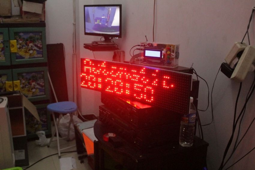
ICE-ELINVO 2019                                                                             IOP Publishing
Journal of Physics: Conference Series           1413 (2019) 012012    doi:10.1088/1742-6596/1413/1/012012

currently there are only 52 units of InaTEWS throughout Indonesia whereas ideally according to the
Indonesian National Disaster Management Agency (BNPB), it should be 1,000 units. In addition to the
limited units, not all of coastal area in Indonesia have InaTEWS towers because the components still
have to be imported from abroad, thus the price is very high. On the other hand, the EWS uses a 140-
450 megahertz HT (Handy Talky) radio frequency thus it is prone to other radio signal interventions and
requires more power.
    Based on these problem, this paper aims at proposing an innovation of the Automatic Tsunami Early
Warning System designed for early informing the occurrence of earthquakes that potentially lead
tsunami in certain regions or area to minimize the casualties. This automatic tsunami early warning
system utilizes earthquake and tsunami potential data available in xml format that can be reused and
downloaded through BMKG's official website, http://data.bmkg.go.id which is updated in real-time
using a mini-PC Raspberry Pi 3 to be processed and sent to targeted locations via SMS (Short Message
Service) to automatically trigger the loudspeakers in places of worship.
    Loudspeakers at places of worship were selected because its accessibility in every place not only on
the coastal area. It is considered a close object that is always available in the public and used as a means
of delivering information in the community. This system can work quickly with a minimum cost because
it was installed as an additional device of the loudspeaker thus it does not require tsunami early warning
towers required by the pre-existing tsunami early warning devices. In addition to its easy and simple
maintenance, the system can be produced in large quantities due to its small size and domestic
components.

2. Research Method
This automatic tsunami early warning system was developed with the Research and Development (RnD)
method that uses the ADDIE (Analyze, Design, Development, Implement, Evaluate) procedure adopted
from Robert Maribe Branch (2009) presented in Figure 1.

                                Figure 1. ADDIE Development Procedure
                                    (Robert Maribe Branch, 2009: 2)

2.1. Analysis Stage
At the analysis stage, the concept of the was prepared based on data obtained from field observations in
several related agencies such as BMKG Yogyakarta Geophysics Station, BPBD Bantul, PUSDALOPS
Bantul, BPBD Kulonprogo and PUSDALOPS Kulonprogo which analyze the weaknesses of the existing
tsunami early warning system.
   The observations revealed that currently, Indonesia used tsunami early warning systems called
InaTEWS (Indonesia Tsunami Early Warning System) whose quantity is only 52 units in total
throughout Indonesia, BPBD Bantul has BISS (Bantul Integrated Siren System) and Kulonprogo BPBD
has EWS (EWS) Early Warning System). BISS and EWS have a collaboration system and the chain
process from BMKG. BPBD broadcasts using radio waves such as HT (Handy Talky) at a frequency of
140-450 megahertz thus it requires large transmitter power, has a weakness against the weather, and
transmits data that were vulnerable to other nearby radio signal interventions.

                                                      2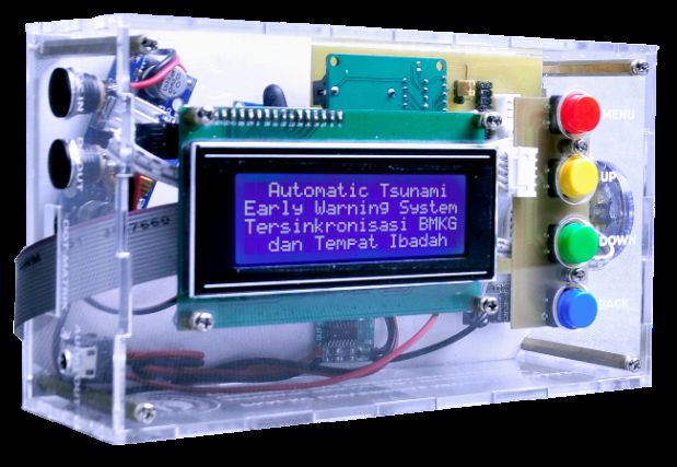
ICE-ELINVO 2019                                                                              IOP Publishing
Journal of Physics: Conference Series             1413 (2019) 012012   doi:10.1088/1742-6596/1413/1/012012

2.2. Design Stage
At this stage, based on the results of the analysis, an automatic tsunami early warning system was
designed. It was generally divided into two main parts, namely the server and the client, as shown in
Figure 2. The server will be located in the centre of the city that has an internet network to take the
earthquake and tsunami data from the BMKG server using the Raspberry Pi 3 mini-PC and process it
into the required information then send it to the location of the potentially tsunami-affected client via
SMS (Short Message Service). The client receives information sent from the server using the GSM SIM
900SA module to trigger the loudspeaker at the places of worship to produce sound automatically. If an
earthquake occurs but it is not potential to cause a tsunami, it will be informed in the form of a voice
instructing the public to remain calm and displaying running text on the dot matrix that informs the
magnitude and depth of the epicentre.
   Whereas if there is a potential for a tsunami, then the voice will inform the community to immediately
evacuate to a higher and safer place and then be followed by a long siren. The dot matrix will display a
running text that displays potential tsunami hazards and instructs the community to immediately
evacuate.

                                        Figure 2. System Block Diagram

2.3. Development Stage
At this stage, the automatic tsunami early warning system was developed according to the results of the
previous draft.

                                                       3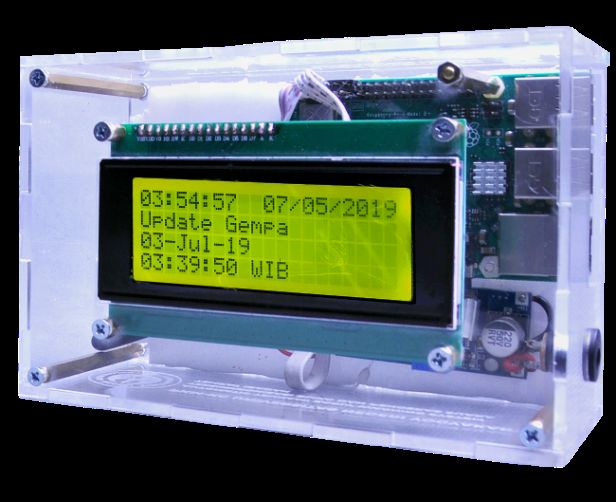
ICE-ELINVO 2019 IOP Publishing
Journal of Physics: Conference Series 1413 (2019) 012012 doi:10.1088/1742-6596/1413/1/012012
Figure 3. Server-Side
Figure 4. Client-Side
The limitation of the problem in this study was in testing the system to broadcast tsunami warning
sirens. It was determined for a limited area of Parangtritis coastal area, Yogyakarta. This test was to
examine how the performance and the accuracy of the broadcast warning messages according to the
predicted location being affected. The server as the main controller in processing tsunami potential data
from BMKG has an important role in determining which area need to be sent tsunami alerts, thus it will
not lead unnecessary panic in the community.
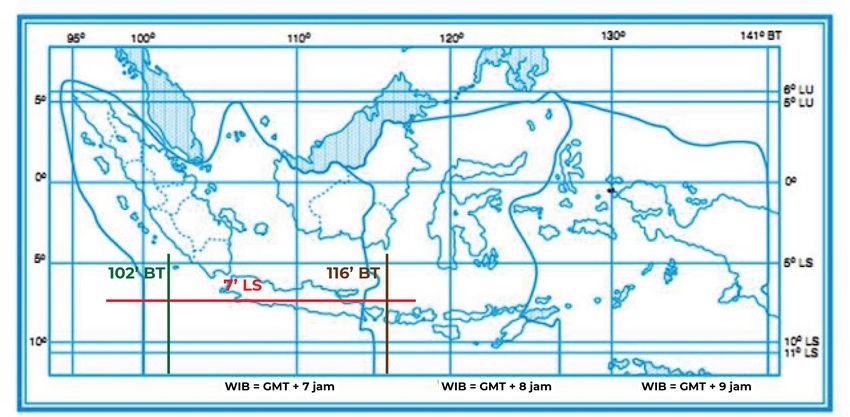
Figure 5. Regional Experiment Mapping
The method used for this problem is to determine the coordinates of the location where the earthquake
occurred. If an earthquake that has tsunami potential is between the coordinates of 102o BT to 116o BT
and more than 7o LS, it will send a tsunami warning message to the Parangtritis coastal area, Yogyakarta.
In the other side, if the earthquake location is outside the determined coordinates, the server will not
send a tsunami warning message. This also applies if there is an earthquake that does not have the
potential for a tsunami. If an earthquake arrives at the location specified above, the system will only
send information messages that the earthquake has no tsunami potential. Table 1 presents the test results.
4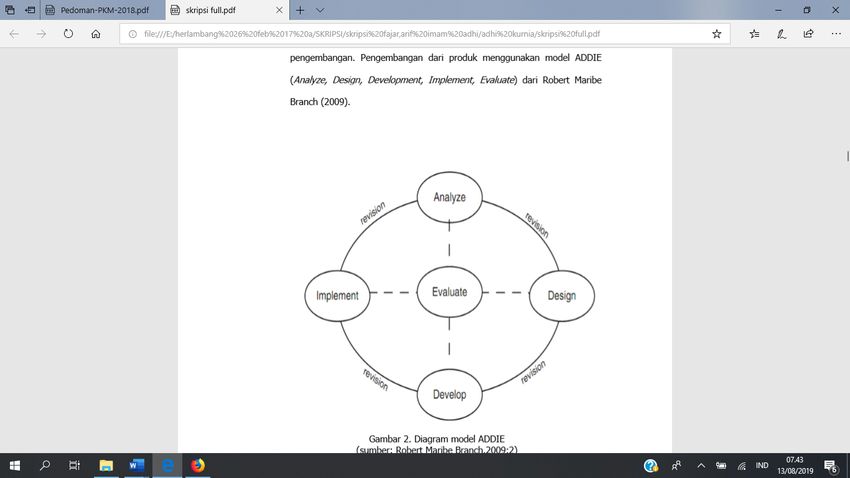
ICE-ELINVO 2019                                                                            IOP Publishing
Journal of Physics: Conference Series           1413 (2019) 012012   doi:10.1088/1742-6596/1413/1/012012

                                        Table 1. Regional Mapping

                         No.        Location               System Reaction
                         1.       8 LS 99o BT
                                    o
                                                     It did not send the message
                         2.      2o LU 110o BT       It did not send the message
                         3.      9o LS 120o BT       It did not send the message
                         4.      9o LS 117o BT       It did not send the message
                         5.      6o LS 115o BT       It did not send the message
                         6.      8o LS 110o BT            It sent the message
                         7.      8o LS 103o BT            It sent the message
                         8.      9o LS 112o BT            It sent the message
                         9.      10o LS 115o BT           It sent the message
                         10.     10o LS 115o BT           It sent the message

2.4. Implementation Stage
After the system is completed and operates as expected, the next step is to implement it in Assalam
mosque, Parangtritis, Bantul, Yogyakarta.

                               Figure 6. Implementation at Assalam Mosque

2.5. Evaluation Stage
The next stage is to evaluate based on the performance, by testing the system at the Yogyakarta
Geophysics station and obtaining some input for evaluation and improvement.

3. Results and Discussion
The results of the automatic tsunami early warning system development showed that on the server-side
located in the center of the city with adequate internet access, the system can retrieve data from the
official BMKG website using Raspberry Pi as a server computer and process it to be sent to the client-
side. This data collection is carried out every 10 seconds to ensure the system gets the latest information
from the BMKG, so that if an earthquake occurs, a potential tsunami warning can be sent faster. The
client-side has been able to receive messages sent by the server using the SIM 900A Module and process
them using the Arduino Nano microcontroller as the main controller in activating the siren and display
earthquake and tsunami information in the form of running text on the dot matrix display to be able to
distinguish whether the warning sirens are turned on tsunami or just an information viewer on the LCD
screen and dot-matrix.
    This tsunami early warning system has been tested at the Assalam mosque, located in the coastal
area of Parangtritis, Bantul, DIY and has been tested at the Yogyakarta Geophysical Station to analyze
its performance and to identify its weaknesses for evaluation and improvement. The testing method was
to simulate a post-earthquake tsunami, by creating a dummy website or a replica website from the

                                                     5
ICE-ELINVO 2019 IOP Publishing
Journal of Physics: Conference Series 1413 (2019) 012012 doi:10.1088/1742-6596/1413/1/012012
official BMKG website because it is not possible to wait for a tsunami in real-time for the trials. The
data contained in the website page can be changed according to the need for the trials in the form of
magnitude, coordinates and the potential for a tsunami to trigger the server computer to send tsunami
information immediately to the client-side.
The trials were designed to examine the level of accuracy of the server computer and information
transmission to the predicted locations which are affected and not affected by the tsunami. The test result
data can be seen in Table 2.
Table 2. Test Results
Experiment Response Time (second)
I 13.8
II 12.2
III 14.5
IV 13.4
V 13.5
Average 13.48
From the test results, it was obtained the average response time of 13.48 seconds.
4. Conclusion
The developed automatic tsunami early warning system is divided into two main parts, namely the server
and the client. The server is a data reader program of earthquakes which have tsunami potential from
the BMKG website, the information processor and the information sender section to the location of the
tsunami. Whereas the client is a recipient program sending information from the server and the driver
section that turns on the loudspeaker automatically. The developed automatic tsunami early warning
system showed high performance and can work effectively as expected. Based on the test results, it was
obtained the average response time of 13.48 to proceed the tsunami information on the BMKG website
to trigger loudspeakers at places of worship.
The main advantages of this automatic tsunami early warning system consist of low production cost,
direct synchronization with the official BMKG website, efficient energy use with only a 12 Volt DC
power source, fast and precise with an average response time of 13.48 seconds and easy maintenance.
5. References
[1] Badan Meteorologi, Klimatologi dan Geofisika. Pedoman Pelayanan Peringatan Tzunami.
2012.
[2] BBC News Indonesia. Deretan Bencana Alam Mematikan yang Menerjang Indonesia
Sepanjang 2018. 2018. Accessed from www.bbc.com/indonesia/ majalah-46691586 on 15
June 2019.
[3] BMKG. Data Gempa Bumi Terbuka BMKG. 2019. Accessed from http://data.bmkg.go.id/
gempabumi/ on 2 August 2019.
[4] Branch, Robert M. Instructional Design: The ADDIE Approach. 2009.
[5] detikNews. Ini Gempa Magnitudo di Atas 7 yang Pernah Guncang Indonesia. 2019. Accessed
from https://news.detik.com/ berita/d-4650883/ini-gempa-magnitudo-di-atas-7-yang-pernah-
guncang-indonesia on 2 August 2019.
[6] MaulidaIffani. Bantul Integrated Sirine System(BISS) as a Bantul Regency Preparedness in
Dealing with Tsunami Hazard. Sumatra Journal of Disaster, Geography and Geography
Education. 2017.
[7] USA:Springer. CNN Indonesia. BNPB: Indonesia Kekurangan Sirine dan Alat Deteksi
Tsunami. 2016. Accessed from https://www.cnnindonesia.com/ nasional/ 20160303195458-20-
115215/bnpb-indonesia-kekurangan-sirene-dan-alat-deteksi-tsunami on June 2019.
6ICE-ELINVO 2019 IOP Publishing
Journal of Physics: Conference Series 1413 (2019) 012012 doi:10.1088/1742-6596/1413/1/012012
7You can also read