Land Use Recovery Plan - Te Mahere Whakahaumanu Taone - Draft Not Government Policy, December 2013 - CERA Document Archive
←
→
Page content transcription
If your browser does not render page correctly, please read the page content below
Land Use Recovery Plan
Te Mahere Whakahaumanu Taone

           Draft Not Government Policy, December 2013

TABLE OF CONTENTS
HE RĀRANGI UPOKO

VOLUME ONE

       Foreword..............................................................................4

       He mihi..................................................................................5

       Executive summary.............................................................6

1.0 1.0 What is the Land Use Recovery Plan?.......................7

2.0 2.0 Vision and goals..........................................................11

3.0 3.0 Recovery needs...........................................................12

4.0 4.0 A plan to lead recovery...............................................17

5.0 5.0 Implementation and monitoring................................42

       Glossary..............................................................................44

       List of appendices.............................................................47

VOLUME TWO
(separate document)

       APPENDIX 1: Amendments to the Canterbury Regional Policy Statement (RPS)
       APPENDIX 2: Amendments to the Christchurch City District Plan
       APPENDIX 3: Amendments to the Waimakariri District Plan
       APPENDIX 4: Amendments to the Selwyn District Plan

                                                                                                    Land Use Recovery Plan   3
FOREWORD
    HE KŌRERO WHAKATAKI

    For greater Christchurch to recover from the Canterbury earthquakes the city and
    surrounding towns need clear, coordinated, and efficient planning documents and processes
    to be in place. Decisions are being made every day about where people want to live and
    where businesses are to be located. This has implications for how greater Christchurch will
    function and develop in the future. This is why I directed Environment Canterbury to develop
    the Land Use Recovery Plan.

    The Land Use Recovery Plan is an important part of the overall Recovery Strategy for
    Greater Christchurch: Mahere Haumanutanga o Waitaha, and aligns with the Christchurch
    Central Recovery Plan, to provide clear direction for residents, businesses and councils of
    greater Christchurch about where development should occur and what form it should take
    to support recovery.

    Consultation during the development of the draft Land Use Recovery Plan showed that
    people of greater Christchurch wanted a clear vision and certainty about development in the
    recovery period and into the future. There was a call for well designed, people-focussed and
    sustainable developments, affordable housing, reduced urban sprawl, a greater diversity of
    housing types, and greater integration with infrastructure provision. The finalised Land Use
    Recovery Plan also takes into account the desires of those who made written comments on
    the draft Land Use Recovery Plan during July 2013. These views have contributed to the 15
    Outcomes of the Land Use Recovery Plan.

    Achieving all of these outcomes is a major undertaking, and much of the work will be done
    by private developers, with councils providing the required policy, regulatory framework and
    infrastructure. That means that there needs to be a very clear understanding about what the
    Recovery Plan does and who is responsible.

    The finalised Land Use Recovery Plan therefore sets out 50 clear actions to be undertaken
    by central government, local councils and other groups. This is a collaborative approach to
    the recovery of metropolitan greater Christchurch and involves working together. Some of
    these actions put planning provisions in place now to achieve outcomes like greater land
    supply, intensification near services and facilities, and redevelopment of areas of social
    housing. Other actions direct agencies to undertake additional work to make changes
    to planning documents in the near future to support recovery, like the review of the
    Christchurch City District Plan. Some actions are not directions, but are agreements with
    and between the strategic partners (Christchurch City Council, Environment Canterbury,
    Selwyn District Council, Te Rūnanga o Ngāi Tahu, Selwyn District Council and Waimakariri
    District Council) and New Zealand Transport Agency to work together to achieve results like
    more coordinated provision of information.

    These actions have been developed to ensure that the Land Use Recovery Plan will achieve
    the desired outcomes, and to support the overall vision of recovery: Greater Christchurch
    recovers and progresses as a place to be proud of – an attractive and vibrant place to live,
    work, visit and invest, mō tātou, ā, mō kā uri ā muri ake nei – for us and our children after us.

    I believe that the Land Use Recovery Plan will be pivotal in creating the certainty and
    direction required for the recovery of greater Christchurch. I look forward to seeing the
    implementation of the plan and working with the strategic partners to achieve the outcomes.
    Recovery is a long process, but by working together the government, local councils, and the
    people of Christchurch can make it happen.

                        Hon. Gerry Brownlee
                        Minister for Canterbury Earthquake Recovery

4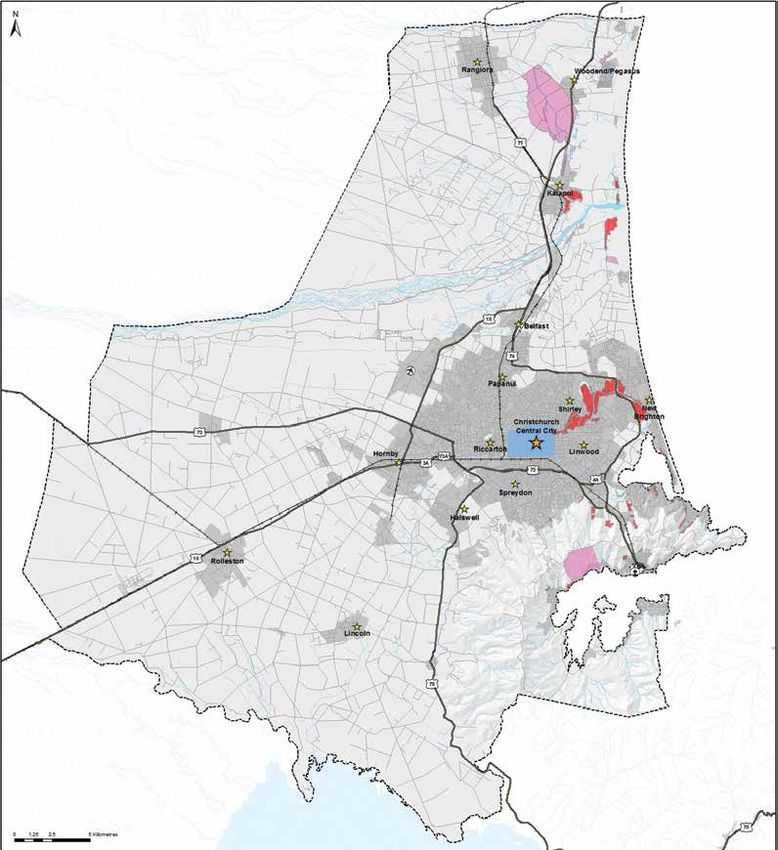
HE MIHI
GREETING

                 E hoa mā, e kā uri whakatipu
                  i muri nei, koi pēnei koutou;
              atawhaitia kā oraka mai o ētahi
               kāika, whakaputa mai ana ki a
                koutou, koi pēnei ki a koutou;
                ahakoa pākehātia koutou, kia
           rakatira e whakahaere mā koutou.

            “To you my friends and my descendants
          who follow after me. Always offer kindness
           and hospitality to those who come to you
               deprived of their homes, lest this may
        happen to you. And always let your standard
           of conduct, as gentlemen, be chivalrous."

                      Ngāi Tahu Ancestor – Natanahira Waruwarutū

Kaiapoi Pā monument. Waruwarutū was resident and present at Kaiapoi Pā when it fell to Te
Rauparaha in the early 1830s. The monument itself was damaged as a result of the earthquakes,
and has since been dismantled for safety reasons and loaned to the City of Christchurch
as a centrepiece of the Quake City exhibition in the Re:START mall. It is a symbol of Ngāi
Tahu’s relationship to the whole Canterbury region, including reserves/papa kāinga, the Treaty
Partnership and land sale and purchase deeds.
                                                                             Land Use Recovery Plan   5
EXECUTIVE SUMMARY
    WHAKARĀPOPOTOTANGA

    The Land Use Recovery Plan helps to achieve the vision          The delivery mechanisms are broken down into 50 actions
    of the Recovery Strategy for Greater Christchurch: Mahere       that local and central government agencies will undertake
    Haumanutanga o Waitaha by providing direction for               to ensure the recovery needs relating to residential and
    residential and business land use development to support        business land use are met. Some actions are statutory
    recovery and rebuilding across metropolitan greater             directions, which use Canterbury Earthquake Recovery Act
    Christchurch in the next 10–15 years. It covers the urban       2011 powers to direct changes to Resource Management
    area of Christchurch (except the central city area covered      Act documents and other statutory instruments. Other
    by the Christchurch Central Recovery Plan) and towns            actions are initiatives that agencies have agreed to
    stretching from Lincoln, Prebbleton and Rolleston in the        undertake to support these changes and help achieve the
    south to Kaiapoi, Rangiora and Woodend/Pegasus in               desired outcomes. The actions support and complement
    the north.                                                      the Christchurch Central Recovery Plan.

    The Canterbury earthquakes have caused significant              Land Use Recovery Plan actions provide for an
    disruption to business and residential areas in Christchurch    anticipated 40,000 new households in both greenfield and
    and nearby towns. There has been a short term loss of           intensification areas. Opportunities for intensification and
    between 10,000 and 20,000 dwellings in metropolitan             infill within existing urban areas are enhanced to provide for
    greater Christchurch, including a relatively high proportion    20,000 new households by 2028. The Recovery Plan also
    of the more affordable housing, including social housing        provides for catalyst 'exemplar' projects for medium density
    units and rental accommodation. Relocation of residents         affordable housing development and options for Māori
    and an influx of recovery workers contribute to a high          wishing to live on their ancestral land.
    demand for housing of all kinds.                                The Land Use Recovery Plan identifies key activity centres
                                                                    and supports these and neighbourhood centres to meet
    Communities have also suffered from damage to local
                                                                    the needs of businesses and communities. It provides
    centres and community facilities. Businesses have had to
                                                                    for 900 hectares of greenfield land to meet the needs
    relocate either temporarily or permanently and many are still
                                                                    of industrial businesses. Infrastructure delivery must
    to make final decisions about their future operations. Travel
                                                                    be coordinated with release of land for both business
    patterns for both people and freight have changed.
                                                                    and housing.
                                                                    The location of greenfield areas for both housing and
      The Land Use Recovery Plan provides delivery                  business has been chosen to avoid natural hazard risks
      mechanisms necessary to:                                      and other environmental constraints. Development of new
                                                                    residential and other noise sensitive activities must also be
      •	provide for a range of housing opportunities,              avoided within identified airport noise contours to avoid
         including social and affordable housing                    adverse effects on the amenity and health of residents
      •	meet the land use needs of residential and                 and the ability of Christchurch International Airport to
         business activities in existing communities and in         function efficiently.
         greenfield areas to accommodate rebuilding and
         growth
      •	support recovery and rebuilding of central city,
         suburban and town centres
      •	ensure that repair and development of transport
         networks and service infrastructure support these
         activities
      •	take account of natural hazards and
         environmental constraints that may affect
         rebuilding and recovery.

6
1.0
1.0	WHAT IS THE
     LAND USE
     RECOVERY PLAN?
	HE AHA TE MAHERE
  WHAKAHAUMANU TĀONE

1.1      What is the purpose of the
         Land Use Recovery Plan?
		       He aha ia te aronga matua o tēnei
         Mahere Whakahaumanu Tāone?
The Canterbury earthquakes have caused significant
disruption to business and residential areas in Christchurch
and nearby towns. The Land Use Recovery Plan provides
direction for residential and business land use development
to support recovery and rebuilding across metropolitan
greater Christchurch in the next 10–15 years.
In particular, the Land Use Recovery Plan addresses:
•	the location and mix of residential and business
   activities
•	priority areas for residential and business land
   development
•	ways to provide for a range of housing types, including
   social and affordable housing
•	ways to support recovery and rebuilding of central city,
   suburban and town centres
•	ways to support delivery of infrastructure and transport
   networks to serve the priority areas.
The Recovery Plan identifies critical actions required in the
short and medium term to coordinate and advance decision
making about land use, as well as who is responsible for
these actions and when they must be completed. These
actions provide certainty for the community, land owners,
infrastructure providers and others about where new
housing and business development will be located, and
how commercial centres and damaged areas should
be redeveloped.
Successful residential and business recovery will foster
a vibrant urban environment for people to enjoy. This will
make metropolitan greater Christchurch a place to be
proud of – for us and our children after us.

                                      Land Use Recovery Plan      7
1.3      Status and effect of the
       What is ‘recovery’?                                                  Recovery Plan
       He aha te ‘whakahaumanu’?                                            Ngā āhuatanga o te Mahere
                                                                            Whakahaumanu Tāone
       The Canterbury Earthquake Recovery Act 2011
       (CER Act) defines recovery in this way:                     The Land Use Recovery Plan has been prepared under
       “Recovery includes restoration and                          the CER Act. It is a statutory document. Any decisions on
       enhancement”                                                resource consents or notices of requirement, or changes to
                                                                   planning documents under the Resource Management Act
       Recovery is concerned with all aspects of the
                                                                   1991 (RMA), must not be inconsistent with the Recovery
       wellbeing of communities – including the social,
                                                                   Plan. The requirement not to be inconsistent with the
       cultural, economic and environmental aspects that
                                                                   Recovery Plan also applies to other instruments under
       contribute to the quality of life for residents and
                                                                   the Local Government Act 2002, including annual plans,
       visitors. This is not limited to earthquake-damaged
                                                                   long-term plans and triennial agreements, to regional
       areas but is also concerned with restoring and
                                                                   land transport strategies and programmes under the
       enhancing greater Christchurch to achieve recovery
                                                                   Land Transport Management Act 2003 and to various
       from the earthquakes in all respects.
                                                                   conservation policies and strategies.
       Similarly, ‘rebuilding’ is not only about restoring
                                                                   The Recovery Plan directs the Christchurch City Council,
       physical structures, but also includes rebuilding
                                                                   Waimakariri and Selwyn District Councils and Canterbury
       communities.
                                                                   Regional Council (Environment Canterbury) to make
                                                                   changes to RMA documents and other instruments to
                                                                   give effect to the Recovery Plan. It needs to be read in
                                                                   conjunction with those changes, which are set out in
    1.2      What does the Land Use                                appendices 1 to 4.
             Recovery Plan cover?
    		       He aha rā te rohe pōtae o tēnei                       1.4      How was the Recovery Plan
             Mahere Whakahaumanu Tāone?
                                                                            developed?
    The Land Use Recovery Plan focuses on the metropolitan         		       Pēhea rā tēnei Mahere
    urban area of Christchurch and towns stretching from                    Whakahaumanu Tāone i
    Lincoln, Prebbleton and Rolleston in the south to Kaiapoi,              whakarite ai?
    Rangiora and Woodend/Pegasus in the north (figure 1). It
    does not extend to the coastal waters adjoining this area.     In November 2012, the Minister for Canterbury Earthquake
                                                                   Recovery, Hon. Gerry Brownlee, directed Environment
    The Land Use Recovery Plan is consistent with the
                                                                   Canterbury to prepare a Draft Land Use Recovery Plan
    Christchurch Central Recovery Plan, and the connections
                                                                   through a collaborative multi-agency approach involving
    between what happens within the central city and what
                                                                   all of the earthquake recovery strategic partners, with
    happens in metropolitan greater Christchurch have been
                                                                   input from key stakeholders and the wider community.
    considered. The Land Use Recovery Plan does not make
                                                                   Environment Canterbury developed the Draft Recovery Plan
    any changes to the Christchurch Central Recovery Plan.
                                                                   in collaboration with:
    Some other matters have been considered, but are not
                                                                   •   Te Rūnanga o Ngāi Tahu (TRoNT)
    specifically addressed because they will be dealt with
    through other programmes. In particular:                       •   Christchurch City Council (CCC)
    •	recovery of resources such as water, air, soil, minerals    •   Selwyn District Council (SDC)
       and energy, plants and animals will be addressed
                                                                   •   Waimakariri District Council (WDC)
       through the Natural Environment Recovery Programme
                                                                   •   New Zealand Transport Agency (NZTA)
    •	future use of land in the areas known as the residential
       red zone will be addressed through the Residential Red      •   Canterbury Earthquake Recovery Authority (CERA).
       Zone Programme.
                                                                   A Preliminary Draft Land Use Recovery Plan was consulted
    Although the Recovery Plan will assist decision making         on through workshops and open forum meetings during
    about infrastructure and community services such as            March and April 2013. This consultation informed the
    public transport, health services, educational facilities      development of the Draft Land Use Recovery Plan which
    and recreational facilities, it does not direct or implement   was provided to the Minister and then publicly notified for
    changes in these areas.                                        written comment in July 2013.
                                                                   The Minister considered the written comments and the
                                                                   requirements of the CER Act before approving the final
                                                                   Land Use Recovery Plan, which was gazetted on
                                                                   6 December 2013.

8
1.0
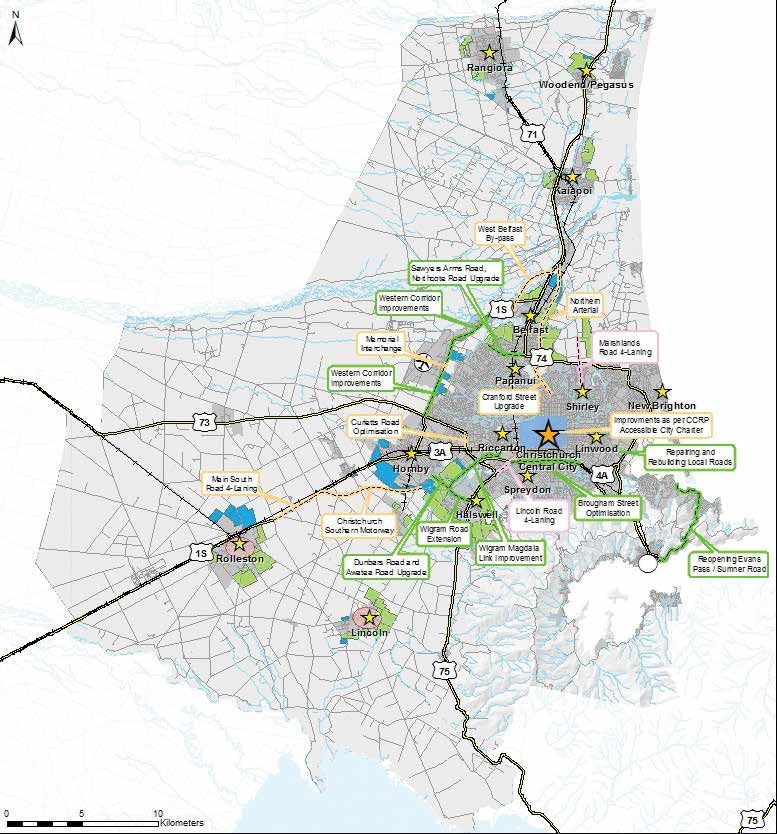
Figure 1: Area covered by the Land Use Recovery Plan
Land Use Recovery Plan 9
1.5      Integration with wider
              recovery planning
     		       Ngā hononga whānui
     The Land Use Recovery Plan has been developed as part                    The following documents are also relevant to implementation
     of the Land and Land Use Programme under the Recovery                    of the Land Use Recovery Plan:
     Strategy’s Built Environment Recovery component and sits
                                                                              •     Greater Christchurch Urban Development Strategy (UDS)
     alongside the Christchurch Central Recovery Plan (figure 2).
                                                                              •     Greater Christchurch Transport Statement (GCTS)
     The implementation of the Land Use Recovery Plan must
     be aligned with implementation of the Christchurch Central               •     Christchurch Economic Development Strategy (CEDS).
     Recovery Plan.

                                              Canterbury Earthquake Recovery Act

                  Recovery Strategy                                            Recovery Components

                                                                                                                          Christchurch Central
                                                                             Leadership and Integration
                                                                                                                            Recovery Plan

                                                                                  Economic Recovery

                                                                                   Social Recovery

                                                                                  Cultural Recovery

                                                                           Natural Environment Recovery

                                                                                                                          Land Use Recovery
                                                                             Built Environment Recovery
                                                                                                                                Plan

     Figure 2: Legislative framework, illustrating the statutory relationship between the Land Use Recovery Plan and the Recovery Strategy

10
2.0
2.0 VISION AND GOALS
KO TE MOEMOEĀ ME ŌNA WAWATA
The Recovery Strategy for Greater Christchurch: Mahere
Haumanutanga o Waitaha (Recovery Strategy) sets the
vision for this Land Use Recovery Plan:
Greater Christchurch recovers and progresses as a
place to be proud of – an attractive and vibrant place
to live, work, visit and invest, mō tātou, ā, mō kā uri
ā muri ake nei – for us and our children after us.
The Recovery Strategy includes six areas of activity:
leadership and integration, economic recovery, social
recovery, cultural recovery, natural environment recovery
and built environment recovery (figure 3). The Land Use The goals of built environment recovery, as set out in
Recovery Plan focuses primarily on the goals for the the Recovery Strategy, are:
recovery of the built environment and is also consistent
Develop resilient, cost-effective, accessible and
with the goals set out in the Recovery Strategy for other
integrated infrastructure, buildings, housing and
areas of activity.
transport networks, by:
• coordinating and prioritising infrastructure
investment that effectively contributes to the
economy and community during recovery and into
the future
• supporting innovative urban design, buildings,
technology and infrastructure to redefine greater
Christchurch as a safe place built for the future
reater Christchurch • rebuilding infrastructure and buildings in a resilient,
t eg y for G
Stra cost-effective and energy-efficient manner
ry
ov e
ec • developing a transport system that meets
eR
th
in the changed needs of people and
as
businesses and enables accessible,
e
ar
sustainable, affordable and safe
y
vit
cti
travel choices
A
3:
ure
• zoning sufficient land for
Fig
recovery needs within
settlement patterns
consistent with an urban
form that provides for the
future development of
greater Christchurch
• having a range of
affordable housing options
connected to community
and strategic infrastructure
that provides for residents’
participation in social, cultural
and economic activities
• drawing on sound information
about ongoing seismic activity and
environmental constraints, including
other natural hazards and climate change.
Land Use Recovery Plan 113.0 RECOVERY NEEDS
KO NGĀ MATEA O TE
HAPORI WHĀNUI
3.1 Change in metropolitan
greater Christchurch
Te hanga rerekē o ngā hapori whai
muri i ngā rū
The distribution of the population of metropolitan greater
Christchurch has changed substantially since before the
earthquakes. Selwyn and Waimakariri districts have both
experienced growth, while Christchurch city has yet to fully
recover to pre-earthquake population levels.
Christchurch city has seen significant population
movement, particularly away from the eastern suburbs
and the city centre. This shift has implications for the
economy, the transport network and how close people are
to employment opportunities, social facilities, entertainment
and recreation.
The make-up of the population will continue to change
in future. There will be an increase in the proportion of
older people (in line with the national trend) and in the
number of workers coming to assist with the rebuild or
choosing to live in the new Christchurch. Such changes
will result in changing demands for housing types and
recreational opportunities.
By 2028, the total population of metropolitan greater
Christchurch is expected to grow from 454,700 (in June
2012) to around 526,000. However, the amount of
growth will be influenced by the policy decisions made
over the next few years. The Land Use Recovery Plan,
in conjunction with other recovery plans, programmes
and strategies, will establish a framework that promotes
metropolitan greater Christchurch as a place where the
residents enjoy a high quality of life and as the best place to
do business in Australasia. Achieving this goal could lead to
population growth beyond current expectations.
3.2 Land use needs
He aha ngā take matua e hua
ana i te whakawhanaketanga o te
whenua?
The earthquakes have changed the communities and built
environment of metropolitan greater Christchurch, affecting
the way that land is or should be used:
• land in some locations is so badly damaged and/or the
level of life risk from rock roll or cliff collapse is such that
it is unlikely it can be rebuilt on for a prolonged period
• many households have relocated, either temporarily or
permanently
• businesses have relocated throughout metropolitan
greater Christchurch3.0
• infrastructure and community facilities have been local facilities have been rebuilt and reopened,
damaged the future of others depends on reinvestment
decisions that are still to be made or on more
• transport movements have changed and some areas of
substantial redevelopments that are not yet
the road network are now more congested
completed. Uncertainty about insurance, surrounding
• repair and rebuild activity is generating its own developments, consent requirements and obtaining finance,
demands, but there are now opportunities to enhance among many other issues, has delayed redevelopment.
the way land is used, which may have been harder to
The strong demand for housing will continue into the
achieve before the earthquakes.
future because:
3.2.1 What are the land use needs for • more households will require temporary
housing? accommodation while their homes are repaired
or rebuilt
The earthquakes have resulted in a loss, in the short term,
of between 10,000 and 20,000 dwellings in metropolitan • rebuild workers coming to metropolitan greater
greater Christchurch. Within the housing stock that has Christchurch will continue to need rental housing,
been lost was a relatively high proportion of more affordable particularly through to 2016/17, although the precise
housing, including social housing units demand and timeframes are difficult to predict
and rental accommodation. • the number of households will grow as new households
Many people are therefore seeking housing, including are formed from within the existing population and
residents relocating from the areas worst affected by land as other households migrate to metropolitan greater
damage as a result of the earthquakes, households that Christchurch.
need to vacate their homes during repairs and rebuilds, a Statistics New Zealand projections suggest there will be
growing rebuild workforce and other migrants coming to an increase of more than 35,000 households by 2028,
the region. This range of needs generates a large demand with two-thirds accommodated in Christchurch city and
for existing houses to own or rent (including social housing), the remaining third split evenly between Waimakariri and
and for new sections on which to build. As a result, house Selwyn districts. This estimate does not include additional
prices and rents have increased significantly in many areas housing demand from households relocating within a
since the earthquakes. territorial area or from the rebuild workers migrating to
Rebuilding and development in areas that are prone metropolitan greater Christchurch. A more complete
to damage from liquefaction are now more complex. picture of anticipated housing demand can be obtained by
Innovative house designs and foundation solutions are including information from housing intention surveys and
being used to deal with this situation. from modelling of workforce requirements, as shown in
table 1 below.
Communities have also suffered from damage to local
centres and community facilities. While some of these
Table 1: Projections for household growth in metropolitan greater Christchurch 2012–2028, including additional earthquake relocation and
temporary housing demand
2012 post- Additional gross housing demand
Greater Christchurch area earthquake
Overall
households 2012–2016 2016–2021 2021–2028
(2012–2028)
Household growth
Christchurch city 143,150 1,500 9,200 13,000 23,700
Waimakariri district 15,250 7,750 2,200 2,200 6,150
Selwyn district 10,050 2,550 2,250 2,500 6,300
Total 168,450 11,800 13,650 16,700 36,150
Earthquake relocation and temporary housing demand
Christchurch city 6,000 –1,000 –1,000 4,000
Waimakariri district 1,000 –300 0 700
Selwyn district 300 –300 0 0
Source: Based on Statistics NZ medium growth projections and other sources
Land Use Recovery Plan 133.2.2 Ngāi Tahu whānui settlement in the east of Christchurch. Businesses have been interrupted
Canterbury and relocated (either temporarily or permanently) and some
businesses have closed. The movement of goods and of
Ko te ahi-kā-roa o Ngāi Tahu whānui ki Ngā people travelling to and from work has also changed.
Pākihi Whakatekateka o Waitaha
Some businesses with damaged premises have already
Some areas in which Ngāi Tahu traditionally had decided to invest in rebuilding at their existing location or
settlements (Ōtākaro, Te Oranga, Ruataniwha) now lie in to relocate elsewhere. Most businesses with damaged
or near land so badly damaged by the earthquakes and/ office and retail premises have found alternative temporary
or subject to an unacceptable level of life risk from rock or permanent accommodation. Some relocated close to
roll or cliff collapse such that it is unlikely to be rebuilt on the central city or to suburban and satellite centres. Others
for a prolonged period. The loss of housing and land has moved into industrial zones, exacerbating a trend that
had a particularly adverse effect on Māori, many of whom began before the earthquakes and heightening concerns
are experiencing less affordable and/or overcrowded related to conflicting expectations of industrial and
accommodation. This can impact on the health and commercial businesses about the amenity of these areas.
wellbeing of communities. These issues have highlighted
an urgent need to implement both interim and permanent Relocations were made easier due to commercial and
land management options that reinforce and re-establish industrial land vacancies that had existed before the
Ngāi Tahu’s historic and contemporary connections with the earthquakes as well as changes to legislation after the
rivers, land and other taonga. earthquakes that have allowed commercial activities in
residential premises until 2016. Many businesses, however,
Before European settlement, Ngāi Tahu, and before are still to make final decisions about their operations.
them Ngāti Māmoe and Waitaha, maintained numerous
permanent and temporary settlements (kāinga, pā and Some industrial businesses that have suffered damage,
nohoanga) within the greater Christchurch area. From including those relying heavily on water and wastewater
these settlements, Ngāi Tahu gathered and used natural infrastructure, are constrained in their ability to relocate due
resources from the network of springs, waterways, to the nature of their activities. In addition, infrastructure
wetlands, grasslands and lowland podocarp forests along capacity for high wastewater requirements is not currently
available elsewhere and may not be for some time.
the Ōpāwaho (Heathcote), Ōtākaro (Avon), Pūharakekenui
Workforces living close to these businesses may not be
(Styx), Whakahume (Cam River at Tuahiwi) and Ruataniwha
able to easily travel to work at a relocated site.
(Cam River at Kaiapoi) rivers, as well as around Te Ihutai
(Avon-Heathcote Estuary), Te Oranga (Horseshoe Lake) Business needs over the lifetime of the Land Use Recovery
and Te Riu o Te Aika Kawa (Brooklands Lagoon). Ngāi Tahu Plan are difficult to predict. The earthquakes have added
refer to Banks Peninsula as Te Pātaka o Rākaihautū or the to the uncertainty about how different segments of the
Food Store House of Rākaihautū. regional economy will change. It is important that this
Recovery Plan provides for a range of business types to
Following the signing of the Treaty of Waitangi, the Crown
support the long-term economic and wider recovery of
purchased the South Island through a series of deeds. One
metropolitan greater Christchurch.
of the conditions of sale was that Ngāi Tahu communities
would continue to have adequate areas of land to occupy Projection of recent uptake rates for industrial land in
on a permanent and seasonal basis to provide for their metropolitan greater Christchurch would suggest a demand
present and ongoing needs, including access to the of around 540 hectares of industrial land for the period to
natural resources that they had hunted and gathered 2028. The rebuild activity will lead to additional growth,
for generations. especially in the construction and manufacturing sectors
which generally require larger sites for their activities.
While certain areas were gazetted as Māori reserves, many
of the Crown’s guarantees were not upheld. As a result, Office and retail needs in metropolitan greater Christchurch
Ngāi Tahu whānui have become alienated from the land over the next 10–15 years will be significantly influenced
that had been set aside for them to live on. One reason why by the vision and successful implementation of the
they continue to be alienated is the nature of the planning Christchurch Central Recovery Plan. Indications are that
rules that have applied to the land. many businesses within Christchurch city will move back
into the more concentrated central core when it offers a
In addressing the housing needs of Ngāi Tahu whānui
rejuvenated environment and new commercial floorspace.
arising from the earthquakes, the Land Use Recovery Plan
The clustering of businesses offers advantages that
provides an opportunity to realise the original intent of those
typically attract professional service companies to a
reserves in meaningful and sustainable ways.
central business district.
As businesses return to the city centre, some will free up
3.2.3 What are the land use needs for
existing commercial space close to the central city and
business? in suburban centres. This could help meet commercial
Outside the central city business area, the earthquakes also demand from businesses that do not wish to operate in
damaged other business premises and land, especially in the core or cannot afford the commercial rents likely to
143.0
be charged for new, higher-grade premises. It will also
provide opportunities for those businesses operating Transport infrastructure
in residential premises which will need to find space in
business zones by April 2016. programmes
Beyond Christchurch city, Selwyn and Waimakariri District The Stronger Christchurch Infrastructure Rebuild
Councils have looked at the needs of key activity centres Team (SCIRT) has established a comprehensive plan
such as Rolleston, Rangiora and Kaiapoi and have to repair and replace the transport network within
developed town centre strategies to support and provide Christchurch city. This programme is being integrated
for the recovery of commercial and industrial businesses. with the Government’s Roads of National Significance
Implementation of these strategies will require the councils projects in the Canterbury region, which the New
to put supporting measures in place. Zealand Transport Agency is implementing, and with
the Christchurch City Council’s 30-year Christchurch
Strategic Transport Plan.
3.2.4 What are the land use issues for
transport? These initiatives have been brought together within
an overarching recovery framework for transport, the
The earthquakes and the changes they have made to Greater Christchurch Transport Statement (GCTS). The
business activities and population movement have had GCTS was produced following the earthquakes through
a significant impact on travel patterns. Congestion in the the collaboration of central and local government
west of the city has increased markedly and delays for and key strategic transport organisations such as
freight traffic are reducing productivity and increasing Christchurch International Airport, Lyttelton Port of
business costs. The capacity of the road network is now Christchurch and KiwiRail.
also reduced due to earthquake repairs and other road
works associated with upgrades to key strategic routes. The GCTS focuses on the strategic links between key
The key alternative route between Lyttelton Port and places within metropolitan greater Christchurch. It takes
Christchurch (Evans Pass–Sumner Road) remains closed a ‘one-network’ approach to delivering objectives of:
due to rockfall risk. • connectedness
Operations at the port and airport have grown significantly • resilience, reliability and efficiency
and are expected to continue to do so in coming years.
Passenger numbers through the airport are expected to • travel choice
increase by 50% by 2028 and freight tonnage will double, • safe journeys
from a relatively low base. By 2028, it is expected that
• liveable communities
Lyttelton Port will need to accommodate a significant
increase in container and other traffic. Increased activity • low environmental impacts.
at both the airport and port will need to be supported by
The GCTS aligns and coordinates agency programmes
effective freight networks and by land use management
so that they get the best value for money and best
that integrates the needs of airport and port operations
transport outcomes.
with the expectations that surrounding communities have
for the amenity of the areas.
The public transport system has experienced a significant 3.2.5 How do natural hazards need to be
drop in the number of people using buses. The managed?
replacement Central Station bus exchange has helped
Metropolitan greater Christchurch is vulnerable to a wide
increase patronage to some extent but it is still down by
range of natural events that create natural hazards for
25% on pre-earthquake levels.
people and property. The Royal Commission of Inquiry into
The pattern of land development to meet residential Building Failures Caused by the Canterbury Earthquakes
and business recovery needs has the potential to affect and other reviews since the earthquakes have highlighted
the functioning of transport networks. Poor integration the need for more robust decision making on land use in
between land use and transport networks reduces the relation to natural hazard management.
efficiency of the networks, increasing costs for businesses
Ongoing research and investigations are needed to improve
and commuters, and also limits opportunities to walk,
understanding of seismic risk; risks and consequences of
cycle or use public transport.
tsunami; susceptibilities to rockfall, cliff collapse, landslide
and land damage; new flood risks to low-lying land arising
from the effects of sea level rise, altered riverbed levels and
intense rainfall events; extended droughts; and liquefaction
risks. In the recovery and development of metropolitan
greater Christchurch, it is essential to take account of areas
at high risk from natural hazards and, where necessary,
avoid development in those areas.
Land Use Recovery Plan 154. RMA plans and regulatory processes enable rebuilding
Guidance for managing and development to go ahead without unnecessary
impediments.
hazards
5. A supportive and certain regulatory environment
The Canterbury Regional Policy Statement 2013 provides investor confidence to obtain the best
contains policy direction on natural hazards. It focuses outcomes from resources used in the recovery.
on the availability of information and guidance, and on
defining and delineating areas susceptible to natural Communities and housing
hazards. In December 2012 Environment Canterbury 6. The range, quality and price of new housing meets the
released an updated liquefaction susceptibility map of diverse and changing needs of those seeking to buy or
metropolitan greater Christchurch, in conjunction with rent, including the needs of a growing temporary rebuild
GNS Science and other partners. workforce.
The Ministry of Business, Innovation and Employment 7. Opportunities are available for the market to deliver
(MBIE) has developed guidelines for the geotechnical comprehensive redevelopment in suitable existing
investigation and assessment of subdivisions in neighbourhoods.
the Canterbury region (December 2012) to direct
geotechnical investigations for new subdivisions and 8. Investment in community facilities and services supports
suggest solutions based on likely land performance. vibrant key activity centres and neighbourhood centres.
Through the Canterbury Geotechnical Database Business
(currently administered by CERA), geotechnical
engineers, consent officers and other suitably qualified 9. Businesses in damaged areas are able to rebuild cost-
professionals can share geotechnical and related effectively and to improve their use of land, buildings,
technical building data to make the rebuild process plant and machinery.
more efficient. 10. Key activity centres and neighbourhood centres provide
The Canterbury Regional Coastal Environment for commercial activity needs and support rejuvenation
Plan prioritises action on coastal erosion and sea- of damaged areas.
water inundation events, and identifies the need for 11. Sufficient industrial business land is available to
investigations where the state of the shoreline and accommodate relocations and industrial sector growth.
hazards in a district have changed significantly.
Transport
As part of the Natural Environment Recovery
Programme, Environment Canterbury is reassessing 12. Congestion arising from road works and from changes
the risks and susceptibilities of natural hazards, and in travel due to development, including business and
investigating and monitoring how earthquakes have household relocations, is minimised.
changed coastal and estuary processes and physical 13. An attractive and financially viable public transport
parameters (building in sea level rise and climate network supports significantly increased use.
variability). Environment Canterbury will report
14. More people walk and cycle in and between centres of
and map the results to inform land use planning
activity and for local trips.
and development.
15. An efficient freight network provides for the needs of
freight transport, particularly in relation to access to the
3.3 Land Use Recovery Plan port and the airport.
outcomes These outcomes form the basis against which the Land
Use Recovery Plan will be monitored (see section 5).
Ngā hua o te Mahere
Whakahaumanu Tāone
In response to the issues described in this section, this
Recovery Plan establishes actions to meet the following
outcomes.
Direction and coordination
1. A clear planning framework directs where and how
new development should occur so that it integrates
efficiently and effectively with infrastructure programmes
and avoids key hazards and constraints.
2. Servicing of land for housing and business and its
release to the market keep pace with anticipated
demand.
3. Land use recovery integrates with and supports wider
recovery activity, particularly within the central city.
164.0
4.0 A PLAN TO LEAD
RECOVERY
Ā TĒNEI
M
MAHERE TE MAHI
WHAKAHAUMANU E
ĀRAHI AI
The Land Use Recovery Plan provides a framework to:
• rebuild existing communities
• develop new communities
• meet the land use needs of commercial and industrial
businesses
• rebuild and develop the infrastructure needed to
support these activities
• take account of natural hazards and environmental
constraints that may affect rebuilding and recovery.
The framework comprises 50 interconnected actions that
will be undertaken to achieve the Recovery Plan outcomes.
Some actions are statutory directions, which use CER Act
powers to direct changes to RMA documents and other
statutory instruments. Other actions are initiatives that
strategic partners have agreed to undertake to support
these changes and help achieve the desired outcomes.
4.1 Rebuilding communities
Ko te mahi whakatika rānei,
whakahou rānei i ngā hapori
Communities in the eastern and hill suburbs of Christchurch
city, in Kaiapoi and near waterways were particularly
affected by the earthquakes. Repair and rebuild
programmes for damaged housing and infrastructure are
well underway, but will take a number of years to complete.
To achieve recovery of neighbourhoods and the centres
that support them, action is needed to provide housing
choice and to revitalise centres.
4.1.1 Provide housing choice
Infill and intensification
Since the earthquakes, a significant proportion of new
housing has been new stand-alone homes, especially
in greenfield subdivisions. Much of this is larger family
housing.
A better supply of smaller, more affordable homes is
needed to offer greater housing choice and meet changing
housing needs. The Land Use Recovery Plan encourages
more intensive housing types, such as terrace and town
house developments, within existing urban areas. As well
as providing smaller and more affordable housing options,
this will:
• allow people to live close to existing communities
and facilities
Land Use Recovery Plan 17• support the recovery of suburban centres and than the theoretical maximum allowed. However, feasible
Christchurch central city opportunities are largely restricted to earthquake-damaged
areas where demolition has been necessary. The Land Use
• make best use of existing infrastructure networks.
Recovery Plan makes immediate changes to the City Plan
The Land Use Recovery Plan puts in place a package of to open up more opportunities.
measures to promote infill and intensification as a way of
achieving these results and complementing residential A new mechanism in the Chirstchurch City Plan provides
development in the central city. for enhanced development of sites over 1,500m2, making
Medium density development is already encouraged in efficient use of available space through innovative design
Christchurch’s inner suburbs through the district plan. to suit the site and neighbourhood. To qualify, sites need
A review Christchurch City Council's district plans will to be close to business centres, open space and public
identify other appropriate areas and enable intensification transport. Developments must also be well designed
in these areas. and ensure that any effects are confined to the site. This
mechanism is available in the Living 2 and Living 3 zones,
Territorial authorities will review development contributions and in Cultural 3 (school) zones where the educational use
and other financial tools and regulatory incentives to ensure of the site has ceased and the underlying zone is Living 2
they actively encourage medium density development in or Living 3.
existing urban areas, particularly to support redevelopment
of the central city. Collaboration by councils with To make use of opportunities provided by existing vacant
developers, finance providers and insurers will help create sites and sites made vacant as a result of the earthquakes
attractive market packages for investment in medium that are below the minimum size for an enhanced
density development. development, the City Plan has been amended to permit
The proportion of new households meeting their needs two residential units to be built on any vacant site in the
through infill and intensified developments in urban areas Living 1 or Living 2 zones, provided that they meet the
has dropped from 37% before the earthquakes to a underlying bulk, location and amenity standards of the zone.
projected 13% in 2013. Attracting people to live within
and around the central city in high quality housing will be These amendments do not affect the central city area (land
critical to supporting the recovery of the central city. The within the five avenues – Bealey, Fitzgerald, Moorhouse,
Land Use Recovery Plan sets targets (in table 2) for the Deans and Harper Avenues), where residential rebuilding
number of new households to be provided through infill will be addressed through the Christchurch Central
and intensification across metropolitan greater Christchurch Recovery Plan.
between now and 2028. Increased targets over time
recognise that, as the package of measures to support Affordable housing
intensification takes effect and changing demographics The quality, attractiveness and affordability of medium
increase the demand for such housing, developer density developments directly influence the market demand
confidence will increase. Most new housing in existing for these housing types. Councils will work collaboratively
urban areas will be built in Christchurch city (including some with interested developers and other agencies to undertake
in the central city), but intensification in other appropriate
exemplar developments demonstrating that good quality
urban areas across metropolitan greater Christchurch is
medium density housing can be built cost-effectively and
also supported.
that, at the right price, there is a significant demand for
Currently, within the main existing residential zones of it. These will be models for future housing developments,
Christchurch city (Living 1, Living 2, Living 3), about 161 providing affordable, attractive and energy-efficient
hectares of bare land could potentially provide for over medium density housing suited to the location. Associated
3,000 new houses if all opportunities within the existing measures to promote intensification, such as improving
zoning rules were taken up. public spaces and amenities, are also encouraged.
Equally, the current residential areas zoned Living 1, Living 2 Opportunities for exemplar developments, including in
and Living 3 have approximately 30,000 fewer houses earthquake-damaged neighbourhoods, have been identified
Table 2: Targets for intensification – households to be provided within existing urban areas as a percentage of total household growth across
metropolitan greater Christchurch, averaged over each period
% target of new households Total households provided in
Projected housing demand
Time period provided in existing urban existing urban areas for each
for each time period
areas for each time period time period
2013–2016 19,100 35% 6,685 households
2016–2021 12,050 45% 5,422 households
2021–2028 15,700 55% 8,635 households
Total new households in existing urban areas by 2028 = 20,742 households
Source: Statistics NZ projections for gross housing demand in metropolitan greater Christchurch and other data
184.0
by Housing New Zealand Corporation and Christchurch
City Council as part of their social housing rebuild Affordable housing
programmes. Other opportunities identified at Riccarton
Racecourse and Halswell will also be developed, tested There is currently no nationally agreed definition
and, if warranted, showcased as exemplar developments. of affordable housing but central government is
These initiatives will include a mix of social housing and developing a definition that will be finalised in 2014.
other tenures and provide models for comprehensive A common definition is that housing is affordable
renewal across the whole social housing stock. when a household spends no more than 30% of its
gross income on housing costs, whether for rent or
Community and social housing mortgage. Other approaches include restricting the
definition to those on the lowest incomes, adjusting
Christchurch city contains areas of residential
the income for household composition, or including
development where a significant proportion of the housing
consideration of housing-related energy and transport
is owned by social and community housing providers.
costs. Affordable housing can be used to mean
These organisations provide a vital service by supplying
lower-priced market housing or subsidised housing.
housing for some of the most vulnerable communities in
greater Christchurch. Social housing
Many of these houses were damaged in the earthquakes Social housing is low-cost rental housing that is
and require rebuilding. As well as this, the pre-earthquake targeted to households that face multiple barriers to
housing stock was increasingly unsuited to the needs accessing housing. Social housing is provided by
of the relevant communities. There is now a significant central government, local government or community
opportunity to improve the overall amenity of these areas housing providers. Not-for-profit housing programmes
by repairing and rebuilding social and community housing, help low- and modest-income households and other
and to provide more effectively for the needs of vulnerable disadvantaged groups to access appropriate, secure
people in greater Christchurch by delivering modern, well- and affordable housing.
designed, efficient and comfortable homes.
A community housing redevelopment mechanism
establishes planning provisions for these areas to enable Immediate accommodation needs
redevelopment and regeneration of existing community Temporary accommodation is needed for rebuild workers
and social housing. This mechanism applies to specific and for householders whose homes are being repaired
areas of Christchurch that contain clusters of social or or rebuilt. This demand competes with demand for
community housing. Redevelopment will be required to permanent rental housing. The likely scale of the temporary
comply with site size and urban design criteria to maintain accommodation demand is difficult to forecast, but it is
amenity and ensure integration with the surrounding expected to increase sharply from early 2014, with peak
neighbourhood. demand occurring by 2016.
The community housing redevelopment mechanism Although some demand is being met through construction of
will assist housing recovery by redevelopment of social new homes, a significant portion is being met by households
and affordable housing in the short to medium term; the sharing homes or taking in boarders, housing made available
mechanism will expire in December 2018. by residents who have left Christchurch permanently, and
Further opportunities for affordable housing and expansion purpose-built worker accommodation and other commercial
of the rental housing supply are provided by the wider infill accommodation. District plans have already been amended,
and intensification package. by directions made under CER Act powers, to enable further
development of temporary accommodation.
Other initiatives to increase the supply of affordable
housing are being considered in the Housing Recovery A shortfall of accommodation while rebuilding proceeds will
Programme. The Ministry of Business, Innovation and place increasing pressure on the existing rental stock. To
Employment’s Social Housing Unit, working with CERA, alleviate this, the Land Use Recovery Plan makes further
Te Rūnanga o Ngāi Tahu, social housing providers and immediate amendments to the City Plan to complement the
other agencies, will also help direct some $31 million measures already taken. These will enable owners of existing
signalled for metropolitan greater Christchurch over the dwellings to provide rental accommodation by converting
next three years to deliver new social housing to support individual dwellings into two units (in the Living 1, Living 2
recovery. Government, councils and the private sector and Living H zones) or by using an existing family flat as an
will investigate ways of managing housing costs, such as independent residential unit. Restrictions on the use and
use of government procurement and influence to achieve ownership of existing elderly persons’ housing developments
economies of scale, home ownership models and housing have also been eased.
assistance schemes for affordable housing.
Brownfield redevelopment
As well as supporting intensification within existing residential
areas, councils will review opportunities for promoting mixed-
use development and redevelopment of brownfield sites,
such as former business sites, in established neighbourhood,
suburban or key activity centres and other suitable locations.
Land Use Recovery Plan 19Redevelopment of appropriate brownfield sites for district plan controls to avoid amenity conflicts with
residential, mixed-use or business development will provide surrounding land uses and to address site problems
the opportunity to foster an integrated community and such as contaminated land. Some brownfield sites in
provide for development of underused or undeveloped residential zones are likely to qualify for the new enhanced
land. Brownfield site redevelopment will be subject to development mechanism included in the City Plan.
Actions to enable recovery
Actions that are statutory directions under the CER Act are shaded in blue; other agreed actions are shaded in yellow.
Provide for housing needs in existing urban areas
Action 1: Immediate amendments to Christchurch City Plan
Christchurch City Council is directed, pursuant to section 24(1)(a) and (b) of the CER Act, To be completed within
to include and remove objectives, policies and methods in the Christchurch City Plan in a fortnight of Gazettal
accordance with appendix 2 (Amendment 1). of this Recovery Plan
Outcomes: 1, 2, 3, 4, 5, 6, 7, 11
Action 2: Christchurch City Council district plan review
Christchurch City Council to enable in the next review of its district plans to provide for the To be completed by
following measures: April 2016
Housing choice
i. a range of housing types and locations recognising the changing population and loss of
housing options as a result of the Canterbury earthquakes
Intensification
ii. a choice of housing through a range of residential density and development provisions to
facilitate intensified development
iii. comprehensive residential and mixed use developments, including on brownfield sites
Supporting rebuilding activities
iv. reduced consenting and notification requirements
v. address the efficiency and effectiveness of urban design provisions.
Outcomes: 1, 2, 3, 4, 5, 6, 7, 8, 11, 14
Action 3: Immediate amendments to Waimakariri District Plan
Waimakariri District Council is directed, pursuant to section 24(1)(a) and (b) of the CER Act, to To be completed within
amend its district plan as set out in appendix 3 (Amendments 3, 4 and 5). a fortnight of Gazettal
of this Recovery Plan
Outcomes: 1, 2, 3, 4, 5, 6, 7, 11, 14
204.0
Action 4: Waimakariri District Plan
Waimakariri District Council is directed, pursuant to section 24(1)(c) of the CER Act, to Details of any
change or vary the objectives, policies and methods of its district plan to the extent necessary changes and variations
to identify appropriate sites, including brownfield sites, within the existing urban area for to be provided to the
intensified residential and mixed-use development and enable comprehensive development of Minister for Canterbury
these sites. Earthquake Recovery
within 6 months
of Gazettal of this
Recovery Plan for the
Minister to determine
any public process
required to give effect
to those amendments
Outcomes: 1, 2, 3, 4, 5, 6, 7, 11, 14
Action 5: Selwyn District Plan
Selwyn District Council is directed, pursuant to section 24(1)(a) and (b) of the CER Act, to To be completed within
amend its district plan as set out in appendix 4 (Amendment 2). a fortnight of Gazettal
of this Recovery Plan
Outcomes: 1, 2, 3, 4, 5, 6, 7, 11, 14
Action 6: Selwyn District Plan
Selwyn District Council is directed, pursuant to section 24(1)(c) of the CER Act, to change or Details of any changes
vary the objectives, policies and methods of its district plan to the extent necessary to identify and variations to
appropriate sites, including brownfield sites, within the existing urban area for intensified be provided to the
residential and mixed-use development and enable comprehensive development of these Minister for Canterbury
sites. Earthquake Recovery
within 6 months
of Gazettal of this
Recovery Plan for the
Minister to determine
any public process
required to give effect
to those amendments
Outcomes: 1, 2, 3, 4, 5, 6, 7, 11, 14
Action 7: Promoting intensification and city living
To support Actions 1 and 2, Christchurch City Council is to develop a package of instruments To be completed within
to promote intensification and city living, including affordable and temporary housing. This 6 months of Gazettal of
may include financial tools, regulatory incentives, development contribution policies and other this Recovery Plan
initiatives.
Agencies (lead
agency in bold):
CCC, CERA, MBIE
Outcomes: 1, 2, 3, 5, 6, 7, 11
Land Use Recovery Plan 21You can also read