Lavaca County Situation Awareness Brief - Wednesday, July 7, 2021 As of 1200 CST
←
→
Page content transcription
If your browser does not render page correctly, please read the page content below
Lavaca County Situation Awareness Brief
  Wednesday, July 7, 2021 As of 1200 CST
Incidents Reported to Lavaca
     County OEM (last 24 hours)
     DATE       SUBJECT     LOCATION   FINAL REPORT

07/06/2021   NO INCIDENTS
             REPORTED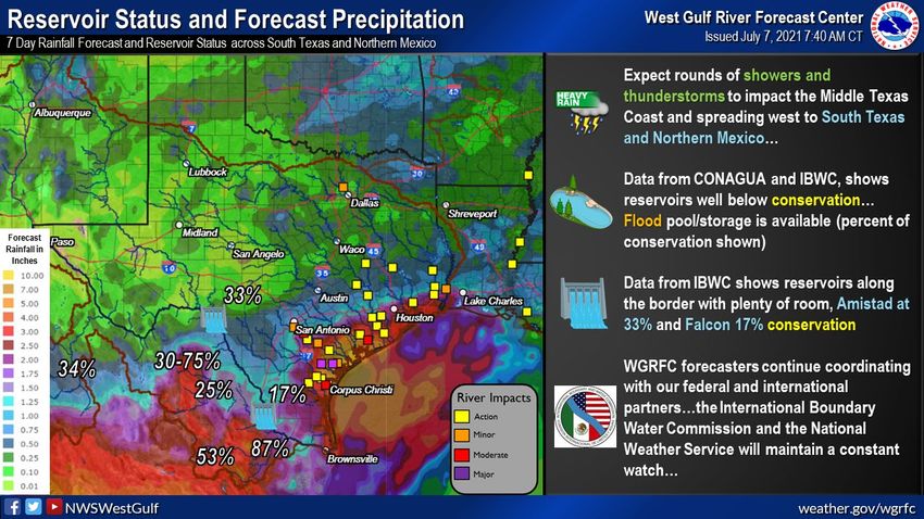
Informational Products
      Distributed by Lavaca OEM
 DATE                                  SUBJECT

07/07/2021   NWS Austin San Antonio: Update - FLASH FLOOD WATCH IN EFFECT FOR
                        LAVACA COUNTY THROUGH FRIDAY MORNING
07/07/2021            Amber Alert: SAN ANTONIO POLICE DEPARTMENT
AMBER ALERT
THE FOLLOWING MESSAGE IS TRANSMITTED AT THE REQUEST OF THE TEXAS
DEPARTMENT OF PUBLIC SAFETY.

THIS IS A CHILD ABDUCTION ALERT ISSUED BY THE TEXAS AMBER ALERT
NETWORK

THE SAN ANTONIO POLICE DEPARTMENT IS SEARCHING FOR KAYEDEN MATTHEW
STUTZMAN, WHITE, MALE, 2 YEARS OLD, 3 FEET 0 INCHES, 25 POUNDS,
BLONDE HAIR, BLUE EYES, WEARING UNKNOWN CLOTHING.

POLICE ARE LOOKING FOR ERIK ANTHONY STUTZMAN, WHITE, MALE, 28 YEARS
OLD, 5 FEET 8 INCHES, 140 POUNDS, BLACK HAIR, BROWN EYES, AND WEARING
UNKNOWN CLOTHING, IN CONNECTION WITH HIS ABDUCTION.

THE SUSPECT IS DRIVING A GRAY 2019 TOYOTA COROLLA WITH A TEXAS
LICENSE PLATE NUMBER OF N T Z 6 4 4 2.

THE SUSPECT WAS LAST HEARD FROM IN SAN ANTONIO, TEXAS.

LAW ENFORCEMENT OFFICIALS BELIEVE THIS CHILD TO BE IN GRAVE OR
IMMEDIATE DANGER.

IF YOU HAVE ANY INFORMATION REGARDING THIS ABDUCTION, CALL THE SAN
ANTONIO POLICE DEPARTMENT AT 2 1 0 2 0 7 7 6 6 0.
AMBER ALERT
Governor Abbott Renews Disaster Declaration Concerning
                   Border Security 1 of 3

TO ALL TO WHOM THESE PRESENTS SHALL COME:

WHEREAS, I, Greg Abbott, Governor of Texas, issued a disaster
proclamation on May 31, 2021, certifying under Section 418.014 of the
Texas Government Code that the surge of individuals unlawfully crossing
the Texas-Mexico border posed an ongoing and imminent threat of disaster
for a number of Texas counties and for all state agencies affected by this
disaster; and

WHEREAS, I amended the aforementioned proclamation on June 25, 2021,
including to modify the list of affected counties and therefore declare a
state of disaster for Brewster, Brooks, Crockett, Culberson, DeWitt, Dimmit,
Edwards, Frio, Goliad, Gonzales, Hudspeth, Jeff Davis, Jim Hogg, Kimble,
Kinney, La Salle, Lavaca, Live Oak, Maverick, McMullen, Midland, Pecos,
Presidio, Real, Terrell, Uvalde, Val Verde, and Zapata counties, and for all
state agencies affected by this disaster; and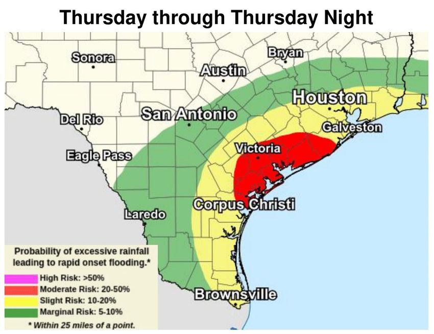
Governor Abbott Renews Disaster Declaration Concerning
                   Border Security 2 of 3
WHEREAS, the certified conditions continue to exist and pose an ongoing
and imminent threat of disaster as set forth in the amended proclamation;
and

WHEREAS, communications with county officials have confirmed that the
certified conditions now also pose an ongoing and imminent threat of
disaster in Colorado, Crane, Galveston, Kenedy, Mason, Medina, and
Throckmorton counties;

NOW, THEREFORE, in accordance with the authority vested in me by
Section 418.014 of the Texas Government Code, I do hereby declare a state
of disaster for Colorado, Crane, Galveston, Kenedy, Mason, Medina, and
Throckmorton counties, and I do hereby renew the disaster proclamation,
as amended, for Brewster, Brooks, Crockett, Culberson, DeWitt, Dimmit,
Edwards, Frio, Goliad, Gonzales, Hudspeth, Jeff Davis, Jim Hogg, Kimble,
Kinney, La Salle, Lavaca, Live Oak, Maverick, McMullen, Midland, Pecos,
Presidio, Real, Terrell, Uvalde, Val Verde, and Zapata counties, and for all
state agencies affected by this disaster. All orders, directions, suspensions,
and authorizations provided in the Proclamation of May 31, 2021, as
amended on June 25, 2021, are in full force and effect.
Governor Abbott Renews Disaster Declaration Concerning
                   Border Security 3 of 3

In accordance with the statutory requirements, copies of this proclamation
shall be filed with the applicable authorities.

IN TESTIMONY WHEREOF, I have hereunto signed my name and have
officially caused the Seal of State to be affixed at my office in the City of
Austin, Texas, this the 30th day of June, 2021.

GREG ABBOTT
Governor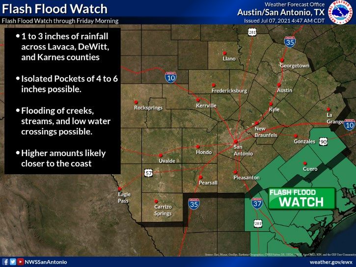
Governor Abbott Urges Land Owners Affected By Border Crisis
         To Submit Self Reporting Damage Survey

Governor Greg Abbott is urging Texas land owners in border communities
who have been affected by the influx of unlawful immigration to complete
the state's Self Reporting Damage Survey to help identify damages suffered
by land owners along the border and inform the state's ongoing efforts to
secure the border.

“I strongly encourage Texas land owners along the border to report any
personal property damages they incur due to unlawful immigration," said
Governor Abbott. "By completing the Self Reporting Damage Survey, our
state will be equipped with the necessary data to continue addressing the
ongoing crisis at our southern border and provide the support our land
owners and communities need to stay safe and secure.”

The voluntary survey, available in both English and Spanish, can be
accessed by visiting: http://damage.tdem.texas.gov. Reporting damage
is a voluntary activity, is not a substitute for reporting damage to an
insurance agency, and does not guarantee disaster relief assistance.
COVID-19 | Lavaca County The Texas Department of State Health Services is beginning to transition back into normal operations, and weekly COVID-19 County Reports will be discontinued. Case counts can still be obtained from the statewide dashboard here. With COVID-19 vaccines now widely available and new infections and hospitalizations down significantly, this information no longer provides the benefit it did during the height of the pandemic. Additional information on the COVID-19 Response may be obtained on the Department of State Health Services - Public Health Region 8 - COVID-19 Website.
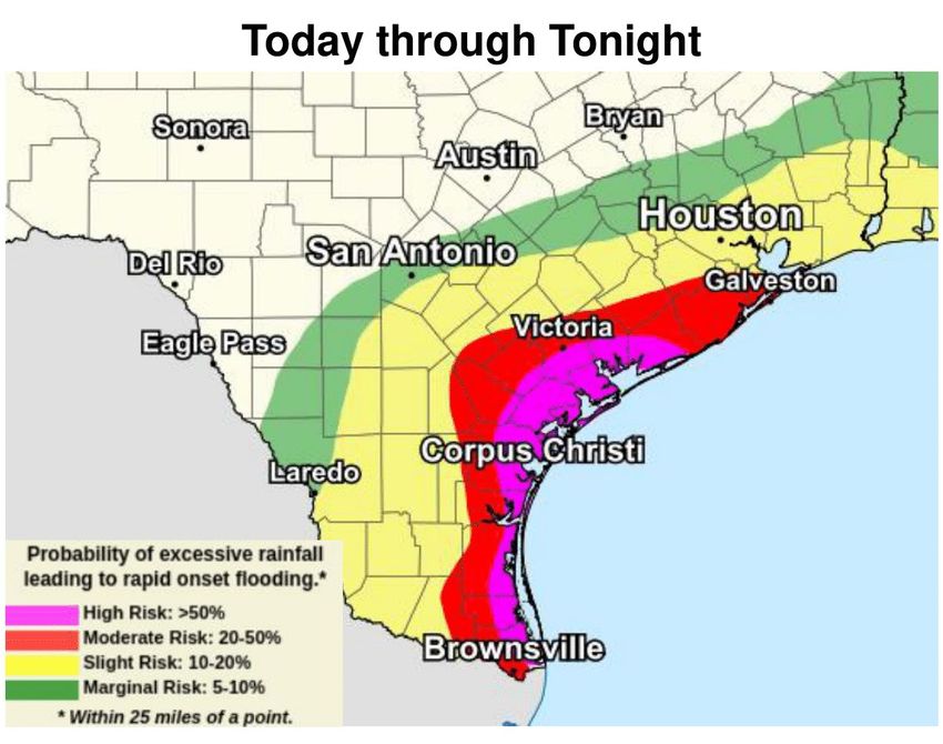
Heavy Rain Threat across Coastal Plains
Important Forecast Changes:

▪ Locally heavy rain threat shifts into Coastal Plains today and Thursday.
▪ Flash Flood Watch issued.

Key Messages:

✓ Numerous showers and storms are forecast today through Friday across the Coastal
Plains, with isolated to scattered showers and storms elsewhere.

▪ 1-3” of rainfall, with isolated pockets up to 6”, is possible across Lavaca, DeWitt, and
Karnes Counties today through Friday – Flash Flood Watch in effect.

▪ Elsewhere across South Central Texas, generally 1 inch of rain or less is forecast
through Friday, however some isolated higher amounts are possible.

▪ Further adjustments are possible to rainfall amounts and watch.

✓ For those with interests along the Texas coast…much higher rainfall amounts are
forecast today through Thursday, where a Moderate to High risk for flash flooding is
forecast.

✓ Remember…Turn Around, Don’t Drown if you encounter a flooded roadway.
Flash Flood Watch
Flash Flood Watch

...FLASH FLOOD WATCH IN EFFECT THROUGH FRIDAY MORNING...

The National Weather Service in Austin/San Antonio has issued a

* Flash Flood Watch for a portion of south central Texas, including
 the following areas, De Witt, Karnes and Lavaca.

* Through Friday morning.

* Rainfall amounts of 1 to 3 inches with isolated amounts of up to 4
 to 6 inches possible.

* The heavy rainfall could lead to flash flooding of creeks,
 streams, and low water crossings.

PRECAUTIONARY/PREPAREDNESS ACTIONS...

You should monitor later forecasts and be prepared to take action
should Flash Flood Warnings be issued.
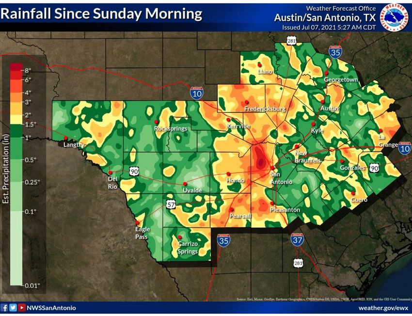
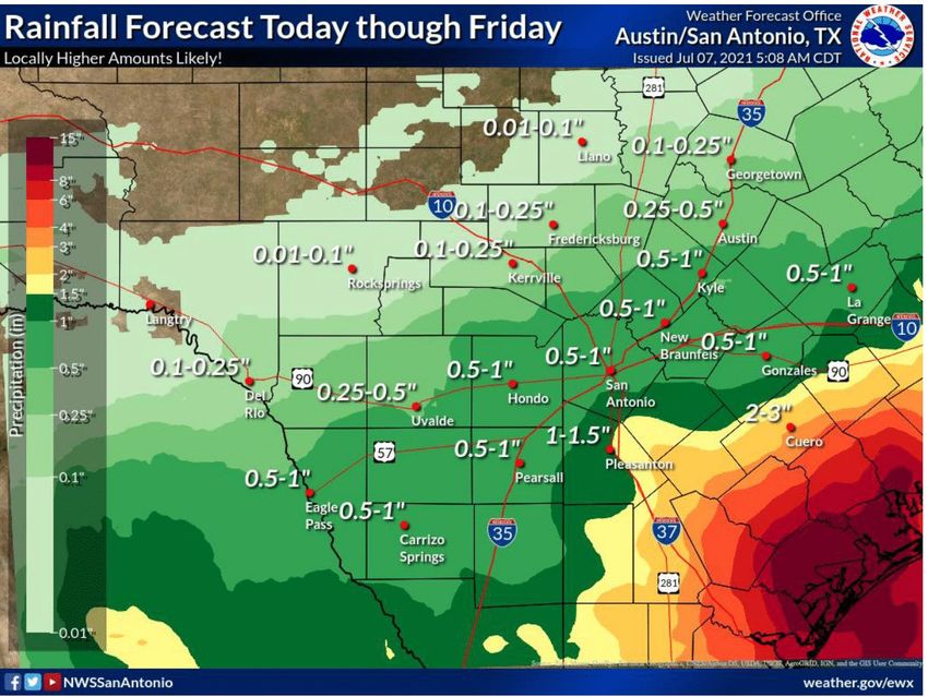
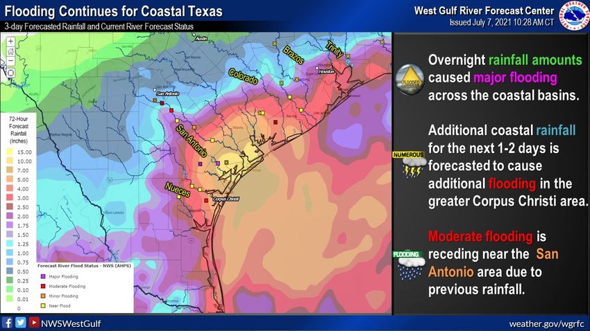
Forecast and Observed Rainfall
Forecast and Observed Rainfall
Excessive Rainfall Outlook
Excessive Rainfall Outlook
Additional Information
Most flood fatalities occur in vehicles, and it only takes 12 inches of water to sweep a car away.
Sometimes the difference between life and death are small decisions. Small decisions like
turning around and not driving through a flooded roadway, not driving around barricades, and
delaying travel until conditions improve, can make a big impact on whether you keep your
car...or even your life. Turn Around, Don’t Drown. weather.gov/safety/flood
Hazardous Weather Outlook
DAY ONE...Today And Tonight.

Scattered to numerous showers and thunderstorms are possible
today and tonight across the Coastal Plains with isolated to
scattered showers and storms across the remainder of South Central
Texas this afternoon and evening. Cloud to ground lightning will
be possible in and near any storms. In addition, locally heavy
rainfall is possible across Lavaca, DeWitt, and Karnes counties
which could lead to flooding. A Flash Flood Watch is in effect for
these counties through Friday morning.

.DAYS TWO THROUGH SEVEN...Thursday through Tuesday.

Scattered to numerous showers and thunderstorms are possible
Thursday through Friday across the Coastal Plains with isolated
to scattered showers and storms across the remainder of South
Central Texas during this time. Cloud to ground lightning will be
possible in and near any storms. In addition, locally heavy
rainfall is possible across Lavaca, DeWitt, and Karnes counties
which could lead to flooding. A Flash Flood Watch is in effect for
these counties through Friday morning.
Hazardous Weather
Hazardous Weather
Hazardous Weather
Precipitation Reports, 07/07/21
LOCATION              AMOUNT         TIME/DATE       PROVIDER

...LAVACA COUNTY...

HALLETTSVILLE 1 SSE         1.53 IN     1110 AM 07/06    LCRA

SHINER 5.1 ESE            1.43 IN    0700 AM 07/06     COCORAHS

HALLETTSVILLE 8.0 N        1.03 IN     0700 AM 07/06     COCORAHS

HALLETTSVILLE (DATAWISE)       0.90 IN    0700 AM 07/06    MESOWEST

1.3 SW SUBLIME (DATAWISE)      0.67 IN     0700 AM 07/06    MESOWEST

HALLETTSVILLE 6.8 WNW         0.62 IN    0700 AM 07/06     COCORAHS

YOAKUM 5.5 NNE             0.62 IN    0800 AM 07/06     COCORAHS

8.9 S EZZELL (DATAWISE)      0.43 IN     0956 AM 07/06    MESOWEST

2.2 N MOULTON (DATAWISE)       0.40 IN    0700 AM 07/06    MESOWEST

HALLETTSVILLE 2.0 NNW        0.37 IN     0700 AM 07/06    COCORAHS

4.6 N SPEAKS (DATAWISE)       0.35 IN    0700 AM 07/06     MESOWEST
Precipitation Reports, 07/07/21
LOCATION                AMOUNT      TIME/DATE       PROVIDER

...LAVACA COUNTY...

6.2 NW HALLETTSVILLE (DATAWI 0.32 IN      0700 AM 07/06    MESOWEST

YOAKUM 6.2 NNE            0.32 IN    0800 AM 07/06    COCORAHS

SHINER 4.1 NE           0.32 IN     0700 AM 07/06    COCORAHS

SHINER 5.8 ENE           0.29 IN    0700 AM 07/06    COCORAHS

7.0 E MOULTON (DATAWISE)      0.19 IN    0700 AM 07/06    MESOWEST

HALLETTSVILLE 17.1 SE      0.18 IN    0700 AM 07/06    COCORAHS

HALLETTSVILLE 5.0 S       0.08 IN    0700 AM 07/06    COCORAHS

MOULTON 6.9 SE           0.07 IN     0700 AM 07/06   COCORAHS

MOULTON 0.3 S            0.02 IN    0700 AM 07/06    COCORAHS
Precipitation Reports, 07/07/21
LOCATION                AMOUNT       TIME/DATE       PROVIDER

...LAVACA COUNTY...

6.2 NW HALLETTSVILLE (DATAWI 0.32 IN       0700 AM 07/06      MESOWEST

YOAKUM 6.2 NNE            0.32 IN     0800 AM 07/06    COCORAHS

SHINER 4.1 NE           0.32 IN     0700 AM 07/06     COCORAHS

SHINER 5.8 ENE           0.29 IN     0700 AM 07/06    COCORAHS

7.0 E MOULTON (DATAWISE)      0.19 IN    0700 AM 07/06     MESOWEST

HALLETTSVILLE 17.1 SE       0.18 IN    0700 AM 07/06    COCORAHS

HALLETTSVILLE 5.0 S        0.08 IN    0700 AM 07/06    COCORAHS

MOULTON 6.9 SE            0.07 IN    0700 AM 07/06    COCORAHS

MOULTON 0.3 S            0.02 IN     0700 AM 07/06    COCORAHS

...DEWITT COUNTY...

YOAKUM 5.9 S             1.54 IN    0700 AM 07/06     COCORAHS

YOAKUM 1 SSW              0.43 IN     0805 AM 07/06    COOP
WEST GULF RFC
Heavy rainfall expected through at least the next 48-72 hours...but
rain does not "end"...expect lingering showers into the weekend.

This is a critical event.

WGRFC forecasters are watching the coastal basins from Falfurrias
through the Corpus Metro to Victoria to Matagorda Bay...Intense
locally heavy rainfall will generate runoff, will generate flood issues,
and will generate river flooding. Expect moderate to major flooding
across the coastal areas in and near any locally heavy rainfall.

For Northern Mexico, WGRFC forecasters are coordinating with IBWC,
and any updates will be reflected in our official forecasts for the Rio
Grande/Rio Bravo. At this time, reservoirs along the border and in
interior Mexico have storage available to hold runoff. Locally heavy
rainfall downstream of reservoirs will be watched closely.

Once the rain ends, rivers will slowly recede through the weekend.
The critical timing is now through Friday for heavy rainfall...so please
be flood prepared and flood aware.
WEST GULF RFC
WEST GULF RFC
LNRA EARLY WARNING SYSTEM:
 LNRA continuously monitors precipitation and
 stream levels around the Lavaca and Navidad
     river basins. Even though the following
information is made available to the public, the
Lavaca-Navidad River Authority will not be held
     responsible for inaccurate information.

          Early Warning System Map

           Rain and Stream Report

           Stream Level Information
Lavaca County River Forecasts:
Lavaca River
Lavaca River at Komensky
Lavaca River at Breslau
Lavaca River at Hallettsville
Navidad River
Navidad River at Sublime
Navidad River near Speaks
Guadalupe River (Yoakum Fire Jurisdiction)
Guadalupe River at HochheimWeather Warnings/Advisories Issued DATE WARNING TYPE LOCATION
Lavaca County Area Weather
Tropical moisture will combine with an upper level disturbance still sitting over the area and lead to
continued chances for showers and storms and below normal temperatures through the end of the
work week. Cloud to ground lightning will be possible in and near any storms. In addition, pockets
of heavy rainfall are possible, leading to localized flooding. The threat for heavy rainfall finally looks
to slow a bit into the weekend. A cold front is forecast to push across central Texas and stalls near
the Hill Country between Sunday night and Monday time frame. Isolated showers and storms
possible across the north and east on Monday.
Lavaca County Weather Forecast
Today: Cloudy with showers likely. A chance of thunderstorms this morning, then
thunderstorms likely this afternoon. Highs in the lower 80s. East winds 10 to 15 mph.
Gusts up to 25 mph this afternoon. Chance of rain 70 percent.

Tonight: Cloudy with a chance of showers and thunderstorms. Lows in the lower 70s.
East winds 5 to 10 mph. Chance of rain 50 percent.

Thursday: Cloudy with showers and thunderstorms likely. Highs in the lower 80s. East
winds 10 to 15 mph. Chance of rain 70 percent.

Thursday Night: Mostly cloudy with a chance of showers and thunderstorms. Lows in
the mid 70s. Southeast winds 5 to 10 mph. Chance of rain 50 percent.

Friday: Mostly cloudy with a chance of showers and thunderstorms. Highs in the mid
80s. Southeast winds 10 to 15 mph. Gusts up to 25 mph in the afternoon. Chance of
rain 50 percent.

Friday Night: Mostly cloudy. A slight chance of showers and thunderstorms after
midnight. Lows in the mid 70s. Chance of rain 20 percent.

Saturday: Partly cloudy. A slight chance of showers and thunderstorms in the morning,
then a chance of showers and thunderstorms in the afternoon. Highs in the upper 80s.
Chance of rain 40 percent.
Lavaca County Weather Forecast
Saturday Night: Partly cloudy. A slight chance of showers and thunderstorms after
midnight. Lows in the mid 70s. Chance of rain 20 percent.

Sunday: Partly cloudy. A slight chance of showers and thunderstorms in the morning,
then a chance of showers and thunderstorms in the afternoon. Highs in the lower 90s.
Chance of rain 30 percent. Highest heat index readings up to 105 in the afternoon.

Sunday Night: Partly cloudy with a slight chance of showers and thunderstorms. Lows
in the mid 70s. Chance of rain 20 percent.

Monday: Partly cloudy. A slight chance of showers and thunderstorms in the morning,
then a chance of showers and thunderstorms in the afternoon. Highs in the lower 90s.
Chance of rain 30 percent.

Monday Night: Partly cloudy. Lows in the mid 70s.

Tuesday: Partly cloudy. A chance of showers and thunderstorms in the afternoon.
Highs around 90. Chance of rain 40 percent.
Tropical Weather Awareness
Monitoring the Tropics - Discussion
Tropical Weather Outlook
NWS National Hurricane Center Miami FL
200 PM EDT Wed Jul 7 2021

For the North Atlantic...Caribbean Sea and the Gulf of Mexico:

The National Hurricane Center is issuing advisories on Tropical
Storm Elsa, located just inland northeast of Perry, Florida.

Tropical cyclone formation is not expected during the next 5 days.
Lavaca County Fire Weather

                   Lavaca County Fire Danger Level: LOW (GREEN)
                   When the fire danger is low it means that fuels do
                   not ignite easily from small embers, but a more
                   intense heat source, such as lightning, may start
                   fires in duff or dry, rotten wood.

           KBDI     Min            Max         Average         Change
         Summary

         Lavaca      14            387           182             -64
Lavaca County Fire Weather No fire weather concerns through the upcoming weekend. Periods of scattered to pockets of numerous showers and thunderstorms will continue through at least Friday, especially over the south half of the region. Some lower rain chances remain in the forecast this weekend into early next week. Minimum RH will remain above 50%, while winds will be primarily light to at times moderate out of the east and southeast. The highest winds are expected on Saturday and Sunday afternoon. A cold front is forecast to stall to our north late Sunday night into Monday while bringing isolated to scattered shower activity into the north and eastern areas. A drier weather pattern is expected from Tuesday through Thursday with showers and storms mainly affecting the Coastal Plains and parts of the southern counties.
Lavaca County Fire Weather
Karnes-De Witt-Lavaca-
Including the cities of Karnes City, Cuero, and Hallettsville
408 AM CDT Wed Jul 7 2021

                Today       Tonight     Thu

Cloud cover       Mcldy       Mcldy      Mcldy
Chance precip (%)    80        50         70
Precip Type       Tstms       Tstms       Tstms
Temp (24h trend)     81 (-2)    72 (-1)     82
RH % (24h trend)     80 (+15)     99 (-1)    79
20ftWnd-AM(MPH)       E 11                 E 9
20ftWnd-PM(MPH)       E 14       E 14       SE 13
Mixing hgt(ft-AGL) 2286                  2395
Transport wnd (MPH) SE 13                  SE 12
CWR              50        50         50
LAL             4        4         4
Haines Index       3         3         3

Remarks...None.
Lavaca County Air Quality Index Forecast Region (Click name for Wed Thu Fri Sat AIRNOW version) 07/07/2021 07/08/2021 07/09/2021 07/10/2021 Victoria Good Good Good Good This forecast was last updated at 9:25 AM on Wednesday, July 7th, and is updated daily on normal TCEQ work days and may also be updated on weekends or holidays when air pollution levels are high. Regardless of our forecast, we always recommend that each individual determine what level of activity they should conduct based on the actual local conditions. See the "Related Current Data" links below to monitor the latest actual conditions.
Lavaca County Air Quality Index
Wednesday 07/07 & Thursday 07/08 - Moderate winds, heavy cloud cover with
scattered precipitation, and/or lower incoming background levels should help keep air
quality in the "Good" range in most spots.

Friday 07/09 - Light amounts of African dust may begin to arrive along the Texas
coastline later in the day. Depending on the intensity of the arriving dust and the
expected ongoing precipitation, the daily PM2.5 AQI could reach the upper end of the
"Good" range (perhaps with an isolated low "Moderate" or two) in parts of the
Beaumont-Port Arthur, Brownsville-McAllen, Corpus Christi, Houston, and Victoria
areas. Otherwise and elsewhere in the state, moderate winds, lingering cloud cover,
and/or lower incoming background levels should help keep air quality in the "Good"
range in most spots.

Saturday 07/10 - African dust is expected to build along the coast while beginning to
spread inland into portions of the Rio Grande Valley, Central, and Southeast Texas.
Overall, depending on the movement, intensity, and coverage of the dust, the daily
PM2.5 AQI is forecast to reach the lower end of the "Moderate" range in parts of the
Brownsville-McAllen and Corpus Christi areas and the upper end of the "Good" range
(perhaps with an isolated low "Moderate" or two) in parts of the Austin, Beaumont-Port
Arthur, Bryan-College Station, Houston, Laredo, San Antonio, and Victoria areas.

Otherwise and elsewhere in the state, moderate winds, lingering cloud cover, and/or
lower incoming background levels should help keep air quality in the "Good" range in
most spots.
Drought Monitor Austin – San Antonio WFO
Lavaca County Cone Zone
MOULTON - Lavaca County Road 283 from LCR 282 to LCR 284 is CLOSED at Lavaca
River Bridge. Weather permitting, the bridge replacement project is expected to be
completed by mid-July 2021.
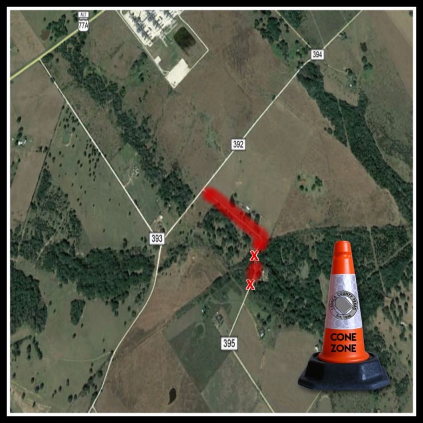
SWEET HOME - Lavaca County
Precinct Three crews and
contractors are currently replacing
two culverts on Lavaca County
Road 395. During the project LCR
395 will be CLOSED from County
Road 392 to the project site. You
may access Lavaca County Road
395 from FM 318.Road/Street Closures This is a partial list of reported road/street closures as reported by State, County, and Local Municipalities, to Lavaca County OEM. TXDOT – Lavaca County No Reported road closures THE CITY OF HALLETTSVILLE - No Reported street closures THE CITY OF MOULTON - No Reported street closures THE CITY OF SHINER - No Reported street closures THE CITY OF YOAKUM - No reported street closures Lavaca County – Lavaca County Road 339 from Gonzales County Road 374 to FM 966 Lavaca County Road 283 from LCR 282 to LCR 284. Lavaca County Road 395 from LCR 392 to culvert replacement site.
Lavaca County Significant Events
   DATE(S)            LOCATION         EVENT               SITE SIZE

07/18/21   07/18/21    MORAVIA    Ascension of Our Lord
                                  Catholic Church Picnic

07/23/21   07/25/21    MOULTON   Moulton Town & Country
                                        Jamboree
***DUE TO A
SCHEDULING CONFLICT,
THE DATE FOR THIS
TRAINING HAS BEEN
CHANGED***
Lavaca County OEM has secured training
from TRANSCAER, and Union Pacific
Railroad, and will be bringing the
RAILROAD 101 class to the Yoakum Fire
Station, 203 Nelson Street, Yoakum,
Texas 77995 one August 17, 2021 from
6 until 10 PM.
The program will provide information
about railroad operations, hazards and
safety rules, Rail Hazmat safety, and
emergency response procedures.
Refreshments, copies of training
materials, & certificate of completion will
be provided after the event.
Please RSVP to
eoc@co.lavaca.tx.us by
August 1, 2021.You can also read