LECT. 3 THE NOTION OF TERRITORY AND THE CONTEMPORARY CONDITION - Giuseppe Strappa
←
→
Page content transcription
If your browser does not render page correctly, please read the page content below
Sapienza – Università di Roma - Facoltà di Architettura

 Urban Morphology Course                                  WKCLM

2018/19

Prof. Giuseppe Strappa
Arch. Anna Rita Donatella Amato,
Arch. Marta Crognale
Arch. Vincenzo Bongiorno,
Arch. Cristian Sammarco

LECT. 3
THE NOTION OF TERRITORY AND THE
CONTEMPORARY CONDITION
Caspar Friedrich,
                                        Wanderer above the
                         Edmund Burke   Sea of Fog - 1818

William Gilpin Observations on the
River Wye (1782)

                                        Giovanni Battista
                                        Piranesi, Tivoli
Salvator Rosa, Landscape with           Waterfall, ca. 1750
Tobias and the Angel, ca. 1660-73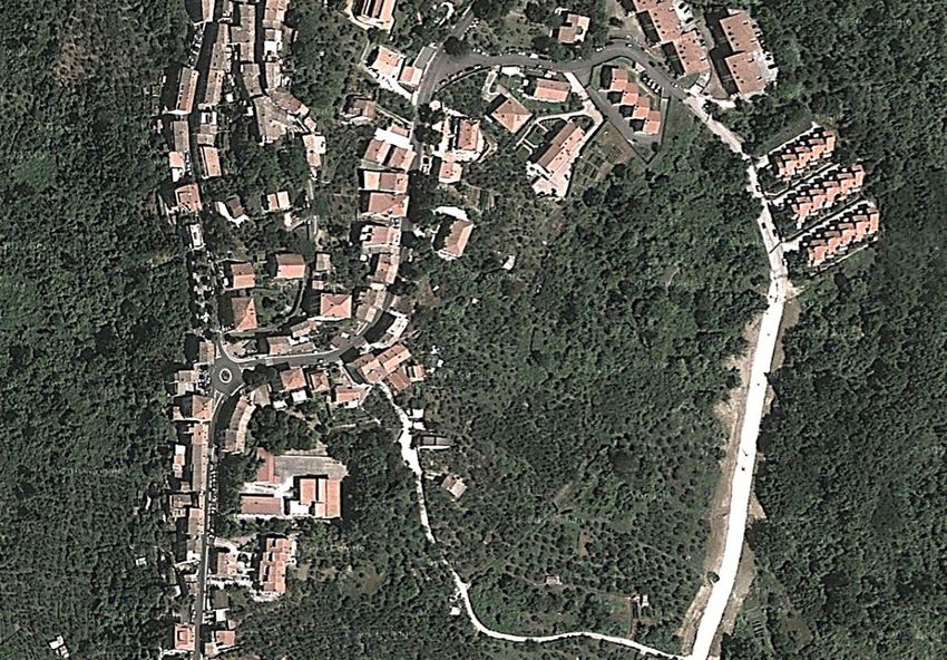
(1845/62)

            Friedrich Ratzel - Otto Schlüter - Carl Sauer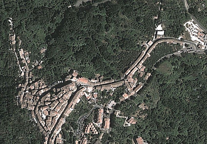
“Life is linked to high regions, very soon ordered by
men.
What are the causes? ” – Braudel writes –
undoubtedly the variety of mountain resources; but
also the rifeness of stagnant water and malaria in
the plains; or uncertain wandering in those river
areas. the plains inhabited nowadays, synonymous
with prosperity, were later creations, achieved after
centuries of collective efforts”
TERRITORIAL ORGANISM
Dyads

                   selection / evaluation
                   specialization / intention                  (conscience) subject

        suitable route                              Occasional / Systematic
        suitable settlement (residential/productive) Occasional / Syst. (reality) object

specializzazione - insediam. tessuto fondiario
polarizzazioni - mercati, fiere, luoghi di pellegrinaggio.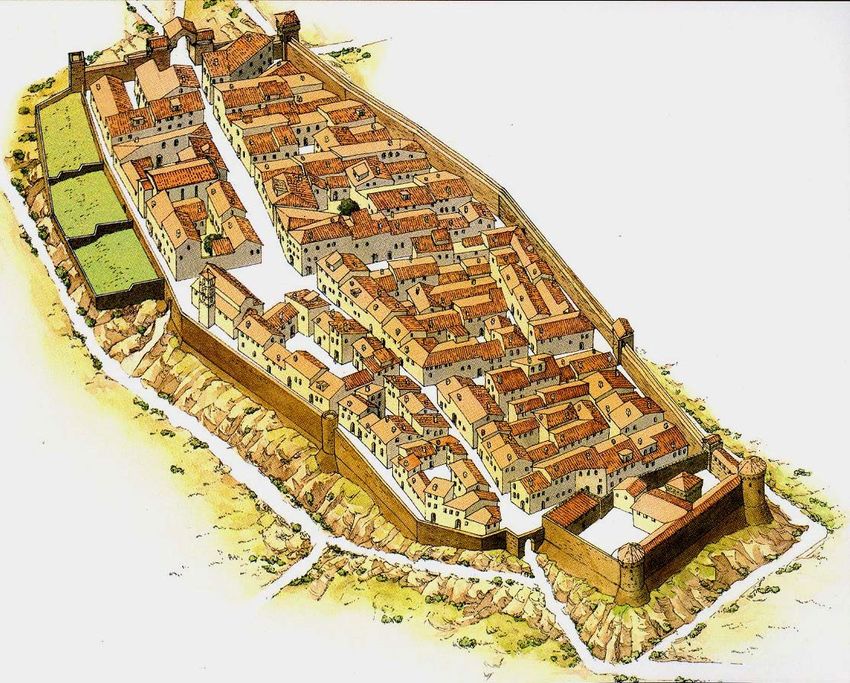
TERRITORY AS AN ORGANISM MADE BY SYSTEMS

• routes system system of the relationships and hierarchisations of the
    routes (from the track to the transport infrastructures)
• settlement system system of the relationship between built
    elements
• land partition system system of the land properties
• productive system system of the use of natural and artificial resources
    (agricultural and manufacturing areas)

•   : ELEMENT, STRUCTURES , SYSTEM, ORGANISM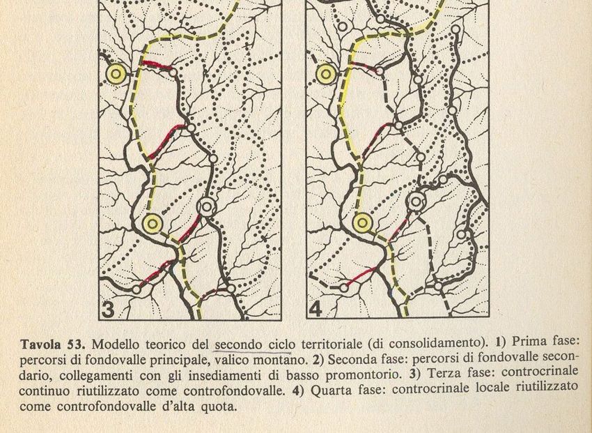
•   territorial routes, originally generated by migrations and, subsequently, by
    the connections between cultural areas of great polarization (the highway
    routes are a contemporary example);

•   local routes, inside each area or between neighboring areas, polarized by
    local settlements;

•   continuous routs, connections between different settlements and cultural
    areas, succession of polarizations;

•   urban routes, internal connections to settlements, to proto-urban nuclei,
    to urban organizations.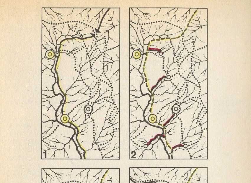
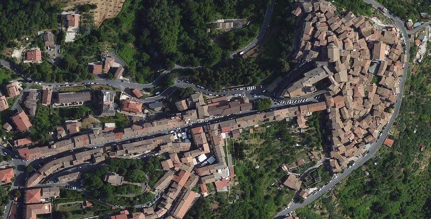
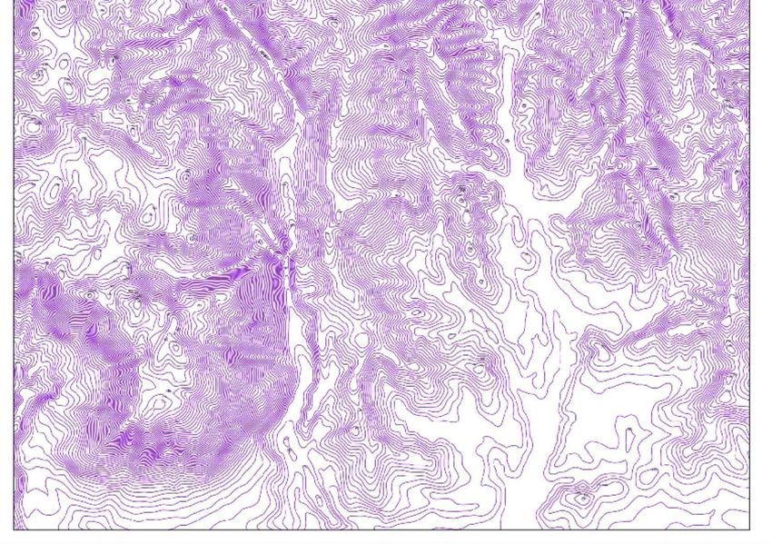
watershed

compluvium
PRIMO CICLO -
IMPIANTO
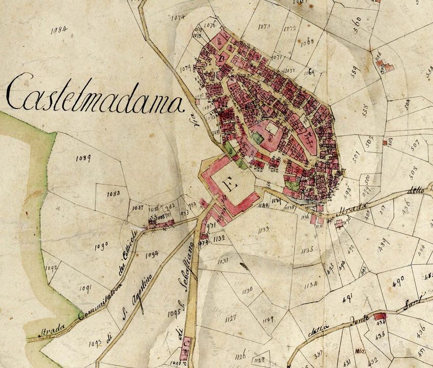
Gallicano

Pertinenza territoriale (area culturale)
Pirenei   Portogallo

Vejinac (Serbia)
•   The main ridge routes, which run along the highest mountain ranges and represent the
    natural location for territorial migration and penetration due to their extension, are
    formed where a more ongoing watershed can be used.
•
    The secondary ridge routes, possible courses along which settlements can be built, are
    formed along the watersheds that branch off from the main ridge, providing access to
    the headlands that branch out, overlooking valleys through secondary promontories.
•
    The local counter-ridge routes replace the main ridge route in some sections and are
    located almost parallel to them. Therefore, they form as “short cuts”, on the high-
    altitude contour lines combining nodal points of the secondary ridge routes. They
    originated from trading needs and not only do they presuppose a basic structure of
    stable settlements, but also an early form of production specialization that makes trade
    necessary.
•
    The continuous counter-ridge routes tend to fully replace the main ridge routes for long
    sections. Generated mainly by the trading needs of production areas, contour lines are
    formed at low altitude creating widespread routes connecting settlements.
•
    The synthetic counter-ridge routes are produced by two ridges with a ford in the middle,
    often representing a short cut to the main ridge
Da G.Cataldi, F. Formichi, Pienza forma urbis, Aiòn, Firenze 2007
Da G.Cataldi, F. Formichi, Pienza forma urbis, Aiòn, Firenze 2007
Da G.Cataldi, F. Formichi, Pienza forma urbis, Aiòn, Firenze 2007
Da G.Cataldi, F. Formichi, Pienza forma urbis, Aiòn, Firenze 2007
S. Muratori
Bellegra, Olevano (disegno 20-aC20): individuazione dei percorsi di crinale, convergenti verso la pedemontana ernica
tra Palestina e Cave, formanti tessuti di insediamenti agricoli separati da compluvi.
•   - implantation cycle, datable from the Paleolithic to the 4th century a.C,
    through which the entire territory is structured, from mountain to the
    valley, through routes and settlements;
•   - consolidation cycle, dating from the Roman expansion of the fourth
    century. to. C. up to the 4th century d. C., through which the already
    implanted structure is stabilized, integrated by the planned structure of
    the partition of the production areas, of the valley bottom routes and of
    the relative urban centers;
•   - recovery cycle, identifiable in the medieval period between the end of
    the 4th century A.D. and the end of the twelfth century, during which the
    structures of the valley bottoms organized in the Roman period were
    disintegrated, and the previous promontory structures were reused,
    transforming them and increasing them;
•   - restructuring cycle, corresponding to the period from the thirteenth
    century to the contemporary age, during which the structures of the valley
    floor partially abandoned in the recovery cycle are reorganized, with
    extensive reclamation works.
SECOND CYCLE (CONSOLIDATION)
•   SECOND CYCLE (CONSOLIDATION)
•   The valley plain routes follow the lines of the orographic system, thus becoming
    opposed and complementary to the ridge paths. They are formed at the end of the
    process of founding the territorial structure, or determined by the internal
    colonization that starts from the coast landings, often settled at the mouth of the
    rivers and connected by a coastal system of distances.
•   In short, we can distinguish:
•   - main valley routes, which do not actually follow the exact line of flood: as the
    ridge paths do not often follow exactly the line of drainage, due to the natural
    difficulties it may have (peaks, walls, etc.) but they adapt to it through elevation
    joints, so the valley floor path may not occupy the immediate location adjacent to the
    waterways, but place itself, more often, close to it, adapting to the flood areas of the
    waterways,.
•   secondary valley bottoms routes, which often depart from the foothills, to follow
    the valleys between two promontories, resulting complementary to the paths of the
    secondary ridge. These routes play an important role in connecting water basins,
    reaching the passes between them.
•   proto-urban nuclei, exchange nodes (through the formation of nodality of routes)
    with the valley, when the phase of occupation and structuring of the plains, often
    swampy and then reclaimed, in which the settlements of the valley plain are
    established, originate above all at the confluence of paths at fords, preferably for
    obvious reasons, before the bifurcation of the rivers, from which further proto-urban
    nuclei develop (for the market role that the territorial nodality assumes) and
    therefore, in cases of strong polarity, urban nuclei.
•   A particular case of the settlement of a low promontory is the acrochoric
    settlement, placed on a high orographic relief
1885 1914 1937 1949 1977 2000
1885 1914 1937 1949 1977 2000
1885 1914 1937 1949 1977 2000
1885 1914 1937 1949 1977 2000
RIDGE ROUTES IN THE URBAN EXPANSION OF LOS ANGELES
RIDGE ROUTES IN THE URBAN EXPANSION OF MEXICO CITY
Giuseppe Strappa,
TERRITORY IS ARCHITECTURE
(From: G.Strappa, P.Carlotti, A.Camiz, Morfologia urbana e tessuti storici. Il progetto contemporaneo dei centri minori del
Lazio, Roma 2017)

   http://www.giuseppestrappa.it/
You can also read