LOCAL NOTICE TO MARINERS - navcen.uscg.gov
←
→
Page content transcription
If your browser does not render page correctly, please read the page content below
U.S. Department
                                                                                     of Homeland Security
                                                                                            United States
                                                                                            Coast Guard

                                    LOCAL NOTICE TO MARINERS
                      District 8 MRS                                                                   Week: 08/21
                                           Mississippi River System
                                                              LIGHT LIST VOLUME V
                                                              NOTICE NUMBER 08-21
                                                                February 24, 2021

                                      LIGHT LIST REFERENCE: COMDTPUB P16502.5, Vol V, 2021 Edition.
                    CONTENTS: Rivers are listed in alphabetical order and are included only when there is information to report.
                                               Broadcast Notice to Mariners Covered in this Edition
                               Originating Unit                        Beginning BNM's                   Ending BNM's
                              Sector Upper Mississippi River          0015 - 21 (UM)                   0020 - 21 (UM)
                              Sector Lower Mississippi River         0065 - 21 (LM)                    0077 - 21 (LM)
                              Sector Ohio Valley                      0035 - 21 (OV)                    0042 - 21 (OV)
                              OB DWB                                 0010 - 21 (DWB)                    0011 - 21 (DWB)

                            COAST GUARD DISTRICT 8, WATERWAYS, (504) 671-2327, 7:00 a.m. until 3:30 p.m. (CST)
              COMMENTS REGARDING SECTION VI – PROPOSED CHANGES MAY ALSO BE EMAILED TO: LocalNoticeFeedback@uscg.mil
                                       NIS WATCHSTANDER PHONE (703) 313-5900 24-HOURS A DAY
                                            INTERNET ADDRESS https://www.navcen.uscg.gov/
                                MISSISSIPPI RIVER SYSTEM LNM VIA INTERNET https://www.navcen.uscg.gov/
             MISSISSIPPI RIVER SYSTEM LIGHT LIST VIA INTERNET https://www.navcen.uscg.gov/pdf/lightLists/LightList_V5_2021.pdf

                                                               ABBREVIATIONS
A through H                                    I through O                                           P through Z

ADRIFT - Buoy Adrift                           I - Interrupted                                       PRIV - Private Aid
AICW - Atlantic Intracoastal Waterway          ICW - Intracoastal Waterway                           Q - Quick
Al - Alternating                               IMCH - Improper Characteristic                        R - Red
B - Buoy                                       INL - Inlet                                           RACON - Radar Transponder Beacon
BKW - Breakwater                               INOP - Not Operating                                  Ra ref - Radar reflector
bl - Blast                                     INT - Intensity                                       RBN - Radio Beacon
BNM - Broadcast Notice to Mariner              ISL - Islet                                           REBUILT - Aid Rebuilt
bu - Blue                                      Iso - Isophase                                        RECOVERED - Aid Recovered
C - Canadian                                   kHz - Kilohertz                                       RED - Red Buoy
CHAN - Channel                                 LAT - Latitude                                        REFL - Reflective
CGD - Coast Guard District                     LB - Lighted Buoy                                     RRL - Range Rear Light
C/O - Cut Off                                  LBB - Lighted Bell Buoy                               RELIGHTED - Aid Relit
CONT - Contour                                 LHB - Lighted Horn Buoy                               RELOC - Relocated
CRK - Creek                                    LGB - Lighted Gong Buoy                               RESET ON STATION - Aid Reset on Station
CONST - Construction                           LONG - Longitude                                      RFL - Range Front Light
DAYMK/Daymk - Daymark                          LNM - Local Notice to Mariners                        RIV - River
DBN/Dbn - Daybeacon                            LT - Light                                            RRASS - Remote Radio Activated Sound Signal
DBD/DAYBD - Dayboard                           LT CONT - Light Continuous                            s - seconds
DEFAC - Defaced                                LTR - Letter                                          SEC - Section
DEST - Destroyed                               LWB - Lighted Whistle Buoy                            SHL - Shoaling
DISCON - Discontinued                          LWP - Left Watching Properly                          si - silent
DMGD/DAMGD - Damaged                           MHz - Megahertz                                       SIG - Signal
ec - eclipse                                   MISS/MSNG - Missing                                   SND - Sound
EST - Established Aid                          Mo - Morse Code                                       SPM - Single Point Mooring Buoy
ev - every                                     MRASS - Marine Radio Activated Sound Signal           SS - Sound Signal
EVAL - Evaluation                              MSLD - Misleading                                     STA - Station
EXT - Extinguished                             N/C - Not Charted                                     STRUCT - Structure
F - Fixed                                      NGA - National Geospatial-Intelligence Agency         St M - Statute Mile
fl - flash                                     NO/NUM - Number                                       TEMP - Temporary Aid Change
Fl - Flashing                                  NOS - National Ocean Service                          TMK - Topmark
G - Green                                      NW - Notice Writer                                    TRLB - Temporarily Replaced by Lighted Buoy
GIWW - Gulf Intracoastal Waterway              OBSCU - Obscured                                      TRLT - Temporarily Replaced by Light
HAZ - Hazard to Navigation                     OBST - Obstruction                                    TRUB - Temporarily Replaced by Unlighted Buoy
HBR - Harbor                                   OBSTR - Obstruction                                   USACE - Army Corps of Engineers
HOR - Horizontal Clearance                     Oc - Occulting                                        W - White

Page 1 of 20                                                                                                                         LNM: 08/21
Coast Guard District 8-MRS                                                                                                           24 February 2021
HT - Height                                     ODAS - Anchored Oceanographic Data Buoy                Y - Yellow

Additional Abbreviations Specific to this LNM Edition:
RIAC - River Industry Action Committee
MMSI - Mobile Maritime Service Identity
AIS - Automatic Identification System
ATON - Aids To Navigation
COTP - Captain of The Port
TRDBN - Temporary Replaced by Daybeacon
C.F.S. - Cubic Feet per Second
IAW - In Accordance With
h.p. - horse power
MPH - Miles Per Hour
TVA - Tennessee Valley Authority
INC - Incorperated

                                                      SECTION I - SPECIAL NOTICES
                                         This section contains information of special concern to the Mariner.

            DEPARTMENT OF HOMELAND SECURITY SUSPICIOUS ACTIVITY
         The Department of Homeland Security (DHS) encourages the maritime public to report information concerning suspicious activity to the local
         Federal Bureau of Investigation Joint Terrorism Task Force (JTTF) Office, http://www.fbi.gov/about-us/investigate/terrorism/terrorism_jttfs, or to
         other appropriate authorities. The U.S. Coast Guard reminds the maritime industry that they may also report information concerning suspicious
         activity to the www.AmericasWaterwayWatch.org, the National Response Center (NRC) 1-800-424-8802 or 1-877-24WATCH.
                                                                                                                     LNM: 02-19

            WESTERN RIVERS FLOATING AIDS TO NAVIGATION
         The U.S. Coast Guard is responsible for placing and maintaining all aids to navigation. Buoys are set to mark project depths taking into
         consideration the prevailing river stages and obstructions. Buoy positions on the Inland Electronic Navigation Chart (IENC) are approximate, and
         subject to change depending on prevailing river stages and obstructions.
         Buoys should always be given as wide a berth in passing as possible, consistent with the length and width of the vessel or tow and the width of
         the bend or crossing.
         Buoys should always be used with caution. They may be carried off position by high water, accumulation of drift, ice, or sunk by collision or other
         causes. In those circumstances buoy marks will remain on the IENC and indicate the last known position of the buoy. Presence of a buoy mark
         on the IENC does not necessarily mean a buoy will be physically on position. When buoys are missing they will be replaced as soon as possible.
                                                                                                                       LNM: 16-19

            GPS TESTING
         At times, throughout our area or responsibility, multiple U.S. Government Agencies conduct GPS testing. These tests vary in duration, affected
         range from the test site and potential impact to the maritime user as they may affect systems that rely on GPS such as E-911, AIS and DSC.
         More information is available at the U.S. Coast Guard Navigation Center Website, https://www.navcen.uscg.gov. During these periods, GPS users
         are encouraged to report any GPS outages that they may experience, to the Navigation Information Service (NIS) by calling (703) 313-5900 or by
         using the NAVCEN Website to submit a GPS problem report.
                                                                                                                      LNM: 07-19

            OHIO RIVER AND TRIBUTARIES - WINTER NAVIGATION
         Attached as an enclosure to this LNM is a USACE Huntington District Notice to Navigation Interests 21-01, regarding winter navigation on the
         Ohio River and tributaries.
                                                                                                                      LNM: 03-21

            USACE HUNTINGTON DISTRICT - LOCKS MAIL DELIVERY AND CREW CHANGE POLICIES
         Attached as an enclosure to this LNM, is a USACE Huntington District Notice to Navigation Interests 21-04, regarding mail delivery and crew
         change policies at navigation locks, for towboats.
                                                                                                                      LNM: 03-21

            USACE HUNTINGTON DISTRICT NOTIFICATION OF SINKING OR SUNKEN VESSELS, VESSEL GROUNDINGS AND BARGE
            BREAKAWAYS
         Attached as an enclosure to this LNM is a USACE Huntington District Notice to Navigation Interests 21-03, regarding notification of sinking or
         sunken vessels, vessel groundings and barge breakaways.
                                                                                                                      LNM: 03-21

            USACE HUNTINGTON DISTRICT - REVIEW OF REGULATIONS AND GENERAL SAFETY PRACTICES
         Attached as an enclosure to this LNM is a USACE Huntington District Notice to Navigation Interests 21-02, regarding the review of regulations and
         general safety practices.
                                                                                                                      LNM: 03-21

Page 2 of 20                                                                                                                              LNM: 08/21
Coast Guard District 8-MRS                                                                                                                24 February 2021
USACE HUNTINGTON DISTRICT RESTRICTED AREAS AT NAVIGATION STRUCTURES
         Attached as an enclosure to this LNM is a USACE Huntington District Notice to Navigation Interests 21-05, regarding restricted areas at
         navigation structures.
                                                                                                                      LNM: 03-21

            USACE HUNTINGTON DISTRICT - 2021 TENTATIVE L/D MAINTENANCE SCHEDULE
         Attached as an enclosure to this LNM is a USACE Huntington District Notice to Navigation Interests 21-08, regarding 2021 tentative L/D
         maintenance schedule of closures.
                                                                                                                      LNM: 04-21

           ARKANSAS RIVER - L/D AVAILABILITY
         Multiple L/D’s on the Arkansas River, have varying states of availability and operations. Closures of locks will occur as local conditions warrant.
         Mariners are encouraged to contact the respective lock masters, for additional information regarding L/D closures or restrictions.
                                                                                                                          LNM: 36-19

            ARKANSAS RIVER - USACE CHANNEL STATUS REPORTS
         Attached as enclosures to this LNM, are USACE Arkansas River Channel Status Reports.
                                                                                                                         LNM: 07-21

             MISSOURI RIVER - AIDS TO NAVIGATION
         All floating aids to navigation, maintained by the U.S. Coast Guard, have been withdrawn for the commercial navigation season. Mariners are
         urged to transit the Missouri River with caution and to utilize all U.S. Coast Guard Broadcasts, the Local Notice to Mariners and electronic chart
         displays, for navigation.
                                                                                                                         LNM: 47-20

            UPPER MISSISSIPPI RIVER/ST. CROIX RIVER/MISSOURI RIVER - DRAWBRIDGE OPERATION
         Attached as an enclosure to this LNM, is Special Public Notice D8 DWB-894, regarding drawbridge operation on the Upper Mississippi River, St.
         Croix River and the Missouri River.
                                                                                                                    LNM: 50-20

            UPPER MISSISSIPPI RIVER - USACE L/D WINTER LOCKAGE HOURS/CLOSURES
         Attached as an enclosure to this LNM is USACE Rock Island District Navigation Notice 20-12890, regarding L/D winter lockage hours and closures.
                                                                                                                    LNM: 48-20

             ARKANSAS RIVER - COVID-19/L/D RESTRICTIONS
         Due to the ongoing COVID-19 concerns, mariners are required to follow the below procedure for crew change out at all Arkansas River L/D’s in
         the USACE Little Rock and Tulsa Districts: Industry shall contact the lock 4-hours in advance of anticipated crew change. The number and names
         of the crew will be provided along with delivery of supplies. No industry personnel shall be allowed inside USACE control houses or buildings during
         crew changes, except in the case of medical emergency. Crew changes will still be allowed on the lock wall but industry must go directly from the
         vehicle to the motor vessel. Industry personnel will be required to use their own facilities while navigating through the lock. The physical
         exchange of trip tickets from crew members to lock staff members will still not be allowed and must be communicated by some other means prior
         to transiting the lock. Questions or requests for additional information, concerning this notice, should be directed to USACE Little Rock District
         Office at (501) 324-5739 or at ceswl-op-om@usace.army.mil.
                                                                                                                         LNM: 42-20

            LOWER MISSISSIPPI RIVER/ARKANSAS RIVER/RED RIVER - CHANNEL CONDITION/SAFETY ADVISORY
         The COTP Lower Mississippi River has issued a Safety Advisory, due to higher than expected channel shoaling and sediment buildup. Mariners are
         advised to transit these rivers with caution, due to the hazardous conditions associated with missing or off station aids to navigation. Fleet
         operators should regularly check their fleets and immediately report barge breakaways to the U.S. Coast Guard Sector Lower Mississippi River via
         VHF-FM Channel 16 or at (866) 777-2744, for further information or to report areas of concern.
                                                                                                                         LNM: 25-20

            UPPER MISSISSIPPI RIVER - L/D CLOSURES
         Attached as an enclosure to this LNM, is USACE St. Paul District Notice to Navigation Interests 20-02, regarding closures at multiple L/D’s along
         the Upper Mississippi River.
                                                                                                                       LNM: 39-20

            L/D CLOSURES - USACE ROCK ISLAND DISTRICT
         Attached as an enclosure to this LNM, is USACE Rock Island District Notice to Navigation Interests 20-12066-2, regarding L/D
         closures/maintenance schedule for 2020-2021.
                                                                                                                     LNM: 46-20

            UPPER MISSISSIPPI RIVER - CHANNEL CONDITION
         Shoaling and low water conditions have been reported between approximate Miles 0.0 and 80.0. Mariners SHALL review all USACE surveys, prior

Page 3 of 20                                                                                                                                LNM: 08/21
Coast Guard District 8-MRS                                                                                                                  24 February 2021
to transiting. The USACE has added several E-Aids to Navigation in the vicinity of Gray’s Landing Point in the vicinity of Mile 46.1, that are being
broadcast to assist mariners transiting. Mariners shall report all navigation obstructions in the area to U.S. Coast Guard MSU Paducah.
LNM: 04-21
UPPER MISSISSIPPI RIVER/ILLINOIS WATERWAY/MISSOURI RIVER - CHANNEL CONDITIONS
Due to prolonged extreme freezing temperatures, forecasts anticipate the formation of ice on the Upper Mississippi River, Illinois Waterway and
Missouri River. Mariners are advised to exercise caution to avoid damaging barges and remain vigilant for unusual currents and high localized
flows or out drafts. Mariners are cautioned to exercise care when entering or departing lock chambers, to avoid damage to the lock gates.
Mariners approaching an ice gorge should make certain that the towboat has sufficient power to properly control the number of barges in tow
under such unusual conditions of flow.
LNM: 06-21
MISSOURI RIVER - CHANNEL CONDITION
A large ice bridge extending bank-to-bank, approximately 100 miles in length, has been reported between approximate Miles 245.0 and 145.0.
Mariners are urged to transit the area with caution, due to additional ice bridges that may be forming in the area.
LNM: 08-21
OHIO VALLEY BASIN - CHANNEL CONDITIONS
The COTP Ohio Valley reminds maritime community stakeholders to take appropriate risk mitigation steps to alleviate potential negative impacts
from high water conditions currently forecast, due to snow and ice melting for the Ohio Valley rivers’ basin. Mariners should closely monitor river
gauge readings and reports of dynamic river currents for safe navigation while departing, arriving and transiting pools and river systems.
Anticipate navigation conditions to deteriorate as weather forecasts signal rapidly rising river conditions. Mariners are advised to transit with
caution.
LNM: 08-21
SECTION II - DISCREPANCIES
This section lists all reported and corrected discrepancies related to Aids to Navigation in this edition. A discrepancy is a change in the status of
an aid to navigation that differs from what is published or charted.
DISCREPANCIES (FEDERAL AIDS)
LLNR Aid Name Status Chart No. BNM Ref. LNM St LNM End
225 Murphys Island Light STRUCT DEST 0600OV 28/18
280 Karns Island Upper Light STRUCT DEST 0651OV 31/18
930 Riverside Light LT IMCH 0149LM 29/18
990 Milligan Bend Light STRUCT DEST 0642LM 51/19
1010 Webber Falls Jetty Light STRUCT DEST 0641LM 51/19
1020 Bluff View Light STRUCT DEST 0640LM 51/19
1055 Hisaw Bottom Light LT EXT 0196LM 40/18
1070 Brier Creek Light STRUCT DEST 0205LM 31/15
1077 Sandtown Bottom Light STRUCT DEST 0457LM 39/19
1200 Black Rock Daybeacon STRUCT DEST 0379LM 35/19
1205 Gans Light STRUCT DEST 0335LM 33/19
1213 Non Lateral Mark 330.4 STRUCT DEST 0087LM 05/16
1220 Onion Creek Daybeacon STRUCT DMGD 0334LM 33/19
1223 Non Lateral Mark 328.5 STRUCT DMGD 0333LM 33/19
1225 Tucker Lake Light STRUCT DEST 0332LM 33/19
1230 Mcnabb Bottom Daybeacon STRUCT DEST 0332LM 33/19
1240 Deadman Slough Light STRUCT DEST 0330LM 33/19
1245 Redland Light STRUCT DEST 0329LM 33/19
1255 Wilsons Rock Light STRUCT DMGD 0380LM 35/19
1265 Peno Point Daybeacon DAYMK DMGD 0580LM 47/19
1267 Non Lateral Mark 313.9 STRUCT DEST 0089LM 05/16
1278 Non Lateral Mark 309.8 STRUCT DMGD 0378LM 35/19
Page 4 of 20 LNM: 08/21
Coast Guard District 8-MRS 24 February 20211305 Fort Smith Light STRUCT DEST 0383LM 35/19
1315 Garrison Creek Daybeacon DAYMK MISSING 0377LM 35/19
1360 Crawford County Daybeacon STRUCT DEST 0378LM 35/19
1365 Jeffrey Light DAYMK MISSING 0376LM 35/19
1390 Fort Chaffee Light STRUCT DEST 0579LM 47/19
1395 Haroldton Light DAYMK MISSING 0578LM 47/19
1400 New Haroldton Light STRUCT DEST 0574LM 47/19
1410 Lavaca Light LT EXT/DAYMK MISSING 0577LM 47/19
1415 Trustee Bend Cutoff Light LT EXT/DAYMK MISSING 0576LM 47/19
1420 Gun Club Lake Daybeacon DAYMK MISSING 0582LM 47/19
1425 Big Creek Light DAYMK MISSING 0581LM 47/19
1427 Big Creek Daybeacon DAYMK MISSING 0575LM 47/19
1430 Arbuckle Island Light STRUCT DEST 0091LM 05/16
1435 Clear Creek Light DAYMK MISSING 0584LM 41/19
1445 Crooked Slough Light STRUCT DEST 0583LM 47/19
1455 Mulberry River Daybeacon STRUCT DEST 0041UM 11/17
1510 Moores Creek Light LT IMCH/STRUCT DMGD 0394LM 44/16
1515 Roseville Daybeacon DAYMK MISSING 0604LM 50/19
1520 O'Kane Island Light LT IMCH/STRUCT DMGD 0393LM 44/16
1525 Alix Bottom Light STRUCT DEST 0605LM 50/19
1530 County Line Daybeacon STRUCT DEST 0606LM 50/19
1532 Non Lateral Mark 246.3 DAYMK MISSING 0607LM 50/19
1535 Kalamazoo Light DAYMK MISSING 0608LM 50/19
1562 Non Lateral Mark 236.3 DAYMK MISSING 0609LM 50/19
1615 Dublin Daybeacon STRUCT DEST 0610LM 50/19
1650 Bunker Hill Upper Daybeacon STRUCT DEST 0639LM 51/19
1660 Bunker Hill Lower Daybeacon STRUCT DEST 0643LM 51/19
1695 Dardanelle Reach Light DAYMK DMGD 0204LM 31/15
1697 Non Lateral Mark 201.4 STRUCT DEST 0200LM 41/18
1700 Elberta Light DAYMK MISSING 0611LM 50/19
1705 Old Neely Daybeacon DAYMK MISSING 0612LM 50/19
1708 Non Lateral Mark 197.9 STRUCT DEST 0052LM 13/17
1710 Point Bar Cutoff Light DAYMK MISSING 0613LM 50/19
1715 Hola Bend Cutoff Light DAYMK MISSING 0614LM 50/19
1725 Reeds Ferry Light DAYMK MISSING 0615LM 50/19
1733 Non Lateral Mark 189.8 DAYMK MISSING 0616LM 50/19
1735 Sweeden Island Light LT EXT/DAYMK MISSING 0617LM 50/19
1738 Non Lateral Mark 188.8 DAYMK MISSING 0618LM 50/19
1740 Galla Creek Light DAYMK MISSING 0619LM 50/19
1745 Wilson Light STRUCT DEST 0620LM 50/19
1770 Willow Bend Lower Daybeacon DAYMK MISSING 0621LM 50/19
1798 Non Lateral Mark 175.6 DAYMK MISSING 0622LM 50/19
1800 Point Remove Creek Light DAYMK MISSING 0623LM 50/19
1815 Ellis Island Light STRUCT DEST 0630LM 51/19
1817 Non Lateral Mark 171.2 DAYMK MISSING 0631LM 51/19
1830 Cypress Creek Light LT IMCH/DAYMK DMGD 0632LM 51/19
1835 Morrilton Cutoff Light DAYMK MISSING 0633LM 51/19
1845 Stane Reach Upper Daybeacon DAYMK DMGD 0634LM 51/19
1850 Stane Reach Light DAYMK DMGD 0635LM 51/19
Page 5 of 20 LNM: 08/21
Coast Guard District 8-MRS 24 February 20211890 Belk Corner Light DAYMK MISSING/STRUCT DMGD 0558LM 45/19
1900 Stanley Bar Light DAYMK DMGD 0559LM 45/19
1903 Non Lateral Mark 150.9 DAYMK MISSING 0560LM 45/19
1905 Hickman Bend Light DAYMK DMGD 0561LM 45/19
1910 Bigelow Light DAYMK MISSING 0562LM 45/19
1915 Bigelow Middle Daybeacon DAYMK DMGD 0563LM 45/19
1920 Bigelow Lower Light DAYMK MISSING 0538LM 44/19
1930 Tri County Light STRUCT DEST 0370LM 41/16
1940 Beaver Dam Creek Daybeacon STRUCT DMGD 0636LM 51/19
1945 Devils Bend Light LT IMCH 0212LM 43/18
1948 Non Lateral Mark 138.8 DAYMK MISSING 0539LM 44/19
1953 Non Lateral Mark 137.6 DAYMK MISSING 0540LM 44/19
1960 Palarm Light DAYMK MISSING 0541LM 44/19
1975 Maumelle River Upper Daybeacon STRUCT DEST 0565LM 45/19
1988 Non Lateral Mark 130.6 DAYMK MISSING 0542LM 44/19
2005 Crystal Hill Light LT IMCH 0047LM 12/17
2030 Burns Park Light STRUCT DEST 0514LM 42/19
2045 Waterworks Bend Light DAYMK DMGD 0515LM 42/19
2125 Fourche Place Cutoff Light LT EXT 0523LM 42/19
2130 Willow Bar Light LT EXT 0524LM 42/19
2143 Non Lateral Mark 106.5 DAYMK MISSING 0637LM 51/19
2160 Estes Place Light DAYMK IMCH/STRUCT DMGD 0396LM 44/16
2173 Non Lateral Mark 99.0 DAYMK MISSING 0638LM 51/19
2199 Non Lateral Mark 92.0 STRUCT DEST 0398LM 44/16
2370 Ste. Marie Bend Lower Daybeacon STRUCT DEST 0407LM 45/16
2435 Richland Bend Middle Daybeacon STRUCT DEST 0099LM 16/18
2485 Little Bayou Meto Lower Daybeacon DAYMK DMGD 0094LM 15/18
2498 Cummins Bend Daybeacon STRUCT DEST 0103LM 06/16
2540 Sample Island Light STRUCT DEST 0106LM 06/16
2550 Sample Island Lower Light STRUCT DEST 0107LM 06/16
2665 Owens Lake Daybeacon DAYMK DMGD 0110LM 06/16
2825 Miller Creek Daybeacon STRUCT DEST 0346OV 18/18
3655 Cages Bend Light STRUCT DEST 0660OV 38/19
3965 Watkins Daybeacon STRUCT DEST 0245OV 19/17
4250 Shammels Mound Landing Light STRUCT DEST 0010OV 02/16
4285 Saline Creek Light STRUCT DEST/TRUB 0221OV 26/16
4315 Pryors Creek Light STRUCT DEST 0030OV 02/20
4340 Devils Elbow Light STRUCT DEST 0306OV 16/18
4390 Crooked Creek Light STRUCT DEST/TRUB 0383OV 36/16
4500 Kuttawa Bar Light STRUCT DEST 0243OV 12/18
4505 Money Cliff Light STRUCT DEST 0364OV 19/18
7035 Drolls Point Light STRUCT DEST/TRLB 0233UM 23/20
7290 Turkey Island Upper Upper Daybeacon STRUCT DEST 0511UM 49/20
7565 Sugar Creek Light STRUCT DEST 0526UM 51/20
7585 Frederick Light STRUCT DEST 0539UM 29/19
7650 Briggs Landing Light LT EXT/STRUCT DMGD 0890UM 51/19
8840 Nine Mile Creek Light STRUCT DEST 0699OV 33/18
8857 Arbuckle Creek Light STRUCT DEST/TRDBN 39/20
9150 Washita Point Light LT EXT 0395LM 33/20
Page 6 of 20 LNM: 08/21
Coast Guard District 8-MRS 24 February 20219185 Preston Peninsula Light REDUCED INT 0420LM 46/16
9456 Six Mile Cut Lower Daybeacon STRUCT DEST 0518UM 47/18
9535 Quaker Oats Light STRUCT DEST 0043OV 06/16
9565 Putney Daybeacon DAYMK DMGD 0768OV 52/19
9590 Iron Bank Light LT EXT 0770OV 52/19
9630 Samuel Light LT EXT 0771OV 52/19
9660 Osage Orange Daybeacon DAYMK DMGD 0773OV 52/19
9663 Barker Daybeacon DAYMK MISSING/STRUCT DMGD 0774OV 52/19
9665 French Point Light STRUCT DEST 0775OV 52/19
9680 Island 8 Chute Upper Daybeacon DAYMK MISSING/STRUCT DMGD 0787OV 52/19
9690 Milton Bell Light LT EXT 0172OV 22/16
9695 Lester Light STRUCT DEST 0777OV 52/19
9700 Island 10 Bar Light LT EXT 0779OV 52/19
9707 Everest Landing Daybeacon DAYMK MISSING/STRUCT DMGD 0780OV 52/19
9715 Groom Towhead Daybeacon STRUCT DEST 0781OV 52/19
9725 Morrison Towhead Daybeacon LT EXT 0788OV 52/19
9770 Nolan Daybeacon DAYMK MISSING 0783OV 52/19
9780 Williams Point Daybeacon DAYMK DMGD 0778OV 52/19
9790 Bixby Towhead Light DAYMK MISSING 0786OV 52/19
9810 Merriwether Bend Light LT EXT/DAYMK MISSING 0791OV 52/19
9825 Carey Upper Daybeacon STRUCT DEST 0648LM 52/19
9830 Little Cypress Bend Light LT EXT/DAYMK DMGD 0649LM 52/19
9845 Murphy Smith Upper Daybeacon STRUCT DEST 0065LM 14/17
9860 Robinson Bayou Light LT EXT 0650LM 52/19
9905 Blaker Towhead Light LT EXT/DAYMK DMGD 0651LM 52/19
9910 Blaker Towhead Lower Light LT EXT 0652LM 52/19
9980 Obion Bar Light LT EXT/DAYMK MISSING 0653LM 52/19
10195 Dean Island Light REDUCED INT 0327LM 33/19
10225 Island 40 Foot Light STRUCT DEST 0232LM 49/18
10540 Harbert Point Light LT EXT 0256LM 36/15
10545 Stumpy Point Light STRUCT DEST 0249LM 52/18
10625 Delta Lower Light STRUCT DEST 0118LM 06/16
10650 Miller Point Light STRUCT DEST 0171LM 14/16
10660 Old Town Bend Foot Light STRUCT DEST 0253LM 36/15
10685 Robson Light STRUCT DEST 0116LM 06/16
10700 Sunflower Cut-Off Foot Light STRUCT DEST 0115LM 06/16
10710 Ludlow Bar Light DAYMK DMGD 0018LM 04/18
10715 Wood Cottage Light STRUCT DEST 0114LM 06/16
10720 Knowlton Light STRUCT DEST 0113LM 06/16
10730 Mason Landing Daybeacon STRUCT DEST 0172LM 14/16
10815 Riverton Middle Bar Light STRUCT DEST 0113LM 21/18
10885 Cypress Bend Light STRUCT DEST 0032LM 07/18
10895 Eutaw Bar Light STRUCT DEST 0365LM 35/19
10905 Mounds Crevasse Lower Light STRUCT DEST 0114LM 21/18
10910 Boliver Light STRUCT DEST 0069LM 11/18
10955 Miller Bend Light STRUCT DEST 0030LM 06/18
10965 La Grange Towhead Light STRUCT DEST 0367LM 35/19
11050 Vaucluse Bend Light STRUCT DEST 0028LM 06/18
11070 Anconia Point Light STRUCT DEST 0368LM 35/19
Page 7 of 20 LNM: 08/21
Coast Guard District 8-MRS 24 February 202111080 Lakeport Light STRUCT DEST 0369LM 35/19
11085 Walnut Point Light STRUCT DEST 0370LM 35/19
11125 Corregidor Light STRUCT DEST 0080LM 05/16
11130 Sarah Island Light STRUCT DEST 0371LM 35/19
11170 Stack Island Light STRUCT DEST 0372LM 35/19
11180 STACK ISLAND LOWER LIGHT STRUCT DEST 0373LM 35/19
11195 Chinaman Light STRUCT DEST 0374LM 35/19
11210 Fitler Point Daybeacon STRUCT DEST 0170LM 28/17
11215 Seitz Light STRUCT DEST 0448LM 38/19
11220 Cottonwood Bar Pointway Light STRUCT DEST 0449LM 38/19
11245 Willow Point Light DAYMK DMGD 0450LM 38/19
11250 Belle Island Corner Daybeacon STRUCT DEST 0451LM 38/19
11250 Belle Island Corner Daybeacon STRUCT DEST/TRDBN 0134LM 22/15
11270 Cabin Teele Light STRUCT DEST 0452LM 38/19
11270 Cabin Teele Light STRUCT DMGD 0079LM 12/14
11275 Marshall Point Cut-Off Daybeacon STRUCT DEST 0453LM 38/19
11280 Joseph Henry Daybeacon STRUCT DEST 0454LM 38/19
11300 Kings Point Light LT EXT 0337LM 35/16
11305 Centennial Island Light LT EXT 0338LM 35/16
11395 Cypress Bunch Light STRUCT DEST 0461LM 39/19
11407 Coggins Light STRUCT DEST 0296LM 29/16
11415 Reid Bedford Point Light STRUCT DEST 0463LM 39/19
11425 Diamond Light STRUCT DEST 0464LM 39/19
11430 Sargent Point Light LT IMCH/DAYMK DMGD 0465LM 39/19
11440 Cannon Point Light STRUCT DEST 0294LM 41/17
11455 Buckridge Light STRUCT DEST 0467LM 39/19
11470 Grand Gulf Island Light STRUCT DEST 0468LM 39/19
11495 Hart Light LT IMCH/DAYMK DMGD 0469LM 39/19
11505 Old Levee Light LT IMCH/DAYMK DMGD 0470LM 39/19
11520 Ashland Light LT IMCH/DAYMK DMGD 0471LM 39/19
11530 Hole In The Wall Light LT IMCH/REDUCED INT 0472LM 39/19
11540 Giles Bend Cut-Off Light STRUCT DEST 0171LM 28/17
11700 Fort Adams Light STRUCT DEST 0402LM 36/19
11795 Morganza Crevasse Light STRUCT DEST 0400LM 36/19
11835 Bayou Sara Bend Light STRUCT DEST 0399LM 36/19
11860 Port Hudson Light STRUCT DEST 0581NOLA 36/19
11900 Devils Swamp Light STRUCT DEST 0397LM 36/19
11940 Ben Burman Light STRUCT DEST 0549LM 44/19
12677 Island 21 Daybeacon STRUCT DEST 0503UM 27/19
13165 Lock 5A Light LT EXT 0172UM 20/20
13230 Island 74 Light STRUCT DEST/TRUB 0380UM 34/20
13430 Root River Upper Light LT EXT 0172UM 20/20
13510 Perry Ruby Light STRUCT DEST 0061UM 12/17
13720 Crooked Slough Head Daybeacon STRUCT DEST/TRUB 0482UM 26/19
13725 Crooked Slough Head Light STRUCT DEST/TRUB 0482UM 26/19
13915 Clayton Lower Daybeacon STRUCT DEST/TRUB 0240UM 31/18
14010 Cassville Upper Daybeacon STRUCT DEST 0546UM 29/19
14030 Cassville Lower Light STRUCT DEST 0546UM 29/19
14055 Milkmans Island Light LT EXT 0172UM 20/20
Page 8 of 20 LNM: 08/21
Coast Guard District 8-MRS 24 February 202114095 Island 214 Light STRUCT DEST/TRLB 0101UM 19/18
14105 Maquoketa Island Light STRUCT DEST 0460UM 25/19
14230 Nine-Mile Island Light STRUCT DEST 0410LM 36/17
14260 Stone Slough Light STRUCT DEST 0454UM 25/19
14275 Fever River Light STRUCT DEST/TRUB 0485UM 45/18
14295 Pulaski Light STRUCT DEST 0485UM 45/18
14385 Arnold Towhead Light STRUCT DEST 0449UM 25/19
14445 Sabula Lower Light STRUCT DEST 0446UM 25/19
15170 Edwards Island Upper Light STRUCT DEST/TRUB 0403UM 26/16
15255 Bakers Point Light STRUCT DEST 0131UM 21/18
16910 Ste. Genevieve Island Light STRUCT DEST 0557UM 30/19
17790 Snyder Bend Upper Daybeacon STRUCT DEST 0863UM 48/19
17795 Snyder Bend Daybeacon DAYMK DMGD 0050UM 08/19
17825 Hutchinson Daybeacon DAYMK DMGD 0050UM 08/19
18545 Wagons Landing Daybeacon STRUCT DEST 0445UM 41/20
18580 Nebraska Bend Daybeacon STRUCT DEST 0445UM 41/20
18765 Little Nemaha River Daybeacon STRUCT DEST 0556UM 49/18
18830 Indian Cave Bend Lower Daybeacon STRUCT DEST 0463UM 26/19
18840 Corning Landing Daybeacon STRUCT DEST 0464UM 26/19
18850 Fargo Daybeacon STRUCT DEST 0464UM 26/19
18860 Lower Cottier Bend Daybeacon STRUCT DEST 0332UM 29/20
19030 Myers Daybeacon STRUCT DEST 0464UM 26/19
23285 Cluster Upper Light STRUCT DEST 0721OV 34/18
24110 Old Lock No. 17 Lower Daybeacon STRUCT DEST 39/20
29258.4 Lock Three Upper Daybeacon STRUCT DMGD 36/20
29272 Deloges Middle Daybeacon DAYMK IMCH 36/20
29340 England Daybeacon STRUCT DEST 36/20
29380 Alexandria Daybeacon STRUCT DEST 36/20
29450 Lock Two Upper Daybeacon DAYMK MISSING 36/20
29467 Hog Lake Daybeacon STRUCT DEST 36/20
29475 Once More Daybeacon STRUCT DEST 36/20
29500 Schampinol Lake Daybeacon DAYMK DMGD 36/20
29535 Johnson Lake Daybeacon STRUCT DEST 37/20
29540 Johnson Bayou Daybeacon STRUCT DEST 37/20
29547 Hadden Fort Middle A Daybeacon MISSING 0436LM 41/11
29555 Hadden Fort Lower Daybeacon STRUCT DEST 37/20
29565 Brouillette Daybeacon STRUCT DEST 37/20
29575 Lake St. Agnes Daybeacon STRUCT DEST 37/20
29597 Larto Middle Daybeacon STRUCT DEST 0049LM 12/17
29600 Larto Bayou Daybeacon STRUCT DEST 0050LM 12/17
29605 Lorran Lake Upper Daybeacon STRUCT DEST 37/20
29618 Red River Entrance Light STRUCT DEST 37/20
29665 Dry Cypress Daybeacon STRUCT DEST 37/20
29690 Bayou Cocodrie Upper Daybeacon STRUCT DEST 37/20
29695 Bayou Cocodrie Daybeacon STRUCT DEST 37/20
29710 Grassy Lake Daybeacon DAYMK MISSING 37/20
29725 Alligator Bayou Daybeacon STRUCT DEST 0216LM 33/17
29750 Timber Lake Daybeacon STRUCT DEST 37/20
29755 Naples Daybeacon STRUCT DEST 37/20
Page 9 of 20 LNM: 08/21
Coast Guard District 8-MRS 24 February 202129775 Three Rivers Junction Light STRUCT DEST 37/20
29780 Barbre Daybeacon STRUCT DEST 37/20
29785 Torras Daybeacon STRUCT DEST 37/20
29795 Oak Grove Daybeacon STRUCT DEST 37/20
31995 Dry Creek Light LT IMCH 0402OV 31/20
32140 Chambers Daybeacon STRUCT DEST 0178OV 11/13
32170 Diamond Island Lower Daybeacon STRUCT DEST 0177OV 11/13
32325 Condors Landing Light STRUCT DEST 0127OV 09/20
32445 Sales Light TRUB/STRUCT DEST 0269OV 19/14
32460 Reynoldsburg Island Light STRUCT DEST/TRUB 0290OV 15/18
32480 Higgins Light STRUCT DEST 0342OV 27/15
32530 Standing Rock Upper Light STRUCT DEST 0658OV 41/13
32585 Pine Bluff Light STRUCT DEST 0308OV 19/19
32600 Clyde Light LT EXT 0581OV 44/15
32605 Newburg Light STRUCT DEST 0362OV 29/15
32650 West Entrance Canal Light LT EXT 0994OV 50/18
32665 Grand Rivers Light LT EXT 0993OV 50/18
DISCREPANCIES (FEDERAL AIDS) CORRECTED
LLNR Aid Name Status Chart No. BNM Ref. LNM St LNM End
None
DISCREPANCIES (PRIVATE AIDS)
LLNR Aid Name Status Chart No. BNM Ref. LNM St LNM End
1685 Oakley Dock Light LT EXT 0307-14 LM 44/14
1690 Mobley Dock Light LT EXT 0454-13 LM 48/13
2100 Oakley Light LT EXT 0520LM 42/19
2337 Island Harbor Marina Light LT EXT 45/16
2340 Century Tube Lights (2) LT EXT 45/16
2400 Pickett And Davison Lights (2) LT EXT 0481-13 LM 50/13
3725 Lakewood Marina Lights (4) LT IMCH 0439-15 OV 34/15
3750 Dupont Dock Lights (2) OFF STA/LT EXT 0305-15 OV 26/15
3795 Nashville Water Intake Lights (2) LT EXT 44/11
3805 Holnam Dock Lights (2) LT EXT 44/11
3815 Kerr-Mcgee Dock Lights (2) LT EXT 44/11
3820 Cohen Terminal Lights (2) LT EXT 44/11
3930 Alcoa Chemical Dock Lights (2) MSLD SIG/LT EXT 0216-10 OV 14/10
3960 Hunter Marine Transport Dock Lights LT EXT 47/08
(2)
3995 Riverview Marina Lights (2) LT EXT 47/08
4055 Clarksville Boat Club Dock Lights (2) LT EXT 0533-12 OV 34/12
6170 Quantum Chemical Dock Lights (2) LT EXT 0436-01 UM 31/01
6580 Consolidated Grain & Barge Lights (2) LT EXT 41/14
6635 Flint Hills Dock Lights (2) LT EXT 0429-14 UM 41/14
6650 S. T. Services Terminal Lights (2) LT EXT 41/14
6695 Continental Grain Company Light LT EXT 41/14
6700 Cargill Lights (3) LT EXT 41/14
7225 Cargo Carriers Dock Lights (2) LT EXT 25/08
7235 Pekin Boat Club Breakwater Light LT EXT 05/16
Page 10 of 20 LNM: 08/21
Coast Guard District 8-MRS 24 February 20217250 Shell Dock Lights (2) LT EXT 0123-02 UM 16/02
7255 Adm Growmark Mooring Light LT EXT 0122-02 UM 16/02
7260 Sours Grain Tramway Light LT EXT 0279-03 UM 21/03
7265 Tomen Dock Light LT EXT 25/08
7295 Adm Growmark Mooring Lights (3) LT EXT 0281-03 UM 21/03
7460 Cargill Mooring Lights (2) LT EXT 0284-03 UM 21/03
7620 Cargill Dock Lights (2) LT EXT 35/08
7725 Cargill Terminal Lights (2) LT IMCH 0171-18 UM 26/18
7730 Public Service Co. Dock Lights (6) LT EXT 0119-18 UM 20/18
7730 Public Service Co. Dock Lights (6) LT IMCH 0171-18 UM 26/18
7760 Adm Growmark Grain Elevator Lights LT IMCH 0171-18 UM 26/18
(2)
8095 Pere Marquette Boat Harbor Light LT EXT 0013-15 UM 04/15
9440 Black Dog Lights (5) LT EXT 43/16
9965 Huffman Grain Light STRUCT DEST 0131-16 LM 08/16
10300 Cargill Dock Light LT EXT 0361-01 LM 34/01
10390 Peavey Lights (2) LT EXT 0398-02 LM 36/02
10395 Suburban Propane Dock Light LT EXT 0396-02 LM 36/02
10415 Western Tar Products Dock Light LT EXT 0394-02 LM 36/02
11943 Bear Industries Barge Dock Lights (4) LT EXT 0600-17 NO 30/17
11990 Riverside Dock Lights (2) LT EXT 0695-01 UM 40/01
12080 University Dock Lights (3) LT EXT 0696-01 UM 40/01
12215 Koch Fuel Dock Lights (2) LT EXT 35/16
12320 Newport Terminal Lights (2) LT EXT 35/16
12385 Shiely Dock Lights (2) LT IMCH 35/16
12712 City of Red Wing Metering Station MISSING 42/16
Special Light
12768 Consolidated Grain and Barge Loading MISSING 42/16
Dock Piling Lights (2)
12930 Alma City Dock Light/Daymarks (3) MISSING 42/16
13405 G. Heileman Brewery Dock Light MISSING 42/16
14756 Isle Of Capri Casino Marina Daybeacon MISSING 03/16
15345 Koch Nitrogen Dock Light LT EXT 41/14
15415 Riverview Park Dock Light LT EXT 0531-15 UM 49/15
15425 Hall Towing Light STRUCT DEST 0280UM 25/20
15822 Hannibal Intake Light LT EXT 0358-20 UM 32/20
16100 Jersey County Grain Dock Lights (2) LT EXT 19/16
16205 Piasa Harbor Light LT EXT 0131-15 UM 22/15
16220 Con-Agra Mooring Lights (2) LT EXT 21/16
16230 Alton Marina Breakwater Lights (3) LT EXT 0131-15 UM 22/15
16265 Amoco Dock Light STRUCT DEST 35/09
16280 Amoco Dock Lights (4) LT EXT 35/09
16310 Sioux City/New Orleans Terminal Light STRUCT DEST 35/09
16380 Western Dock Lights (9) LT IMCH 34/08
16390 Adm-Growmark Dock Lights (4) LT EXT 0776-01 UM 44/01
16430 Union Electric Coal Dock Lights (2) LT EXT 0305-08 UM 34/08
16445 Continental Cement Lights (2) LT EXT 0305-08 UM 34/08
16505 Peavey Company Dock Lights (3) LT EXT 0305-08 UM 34/08
16530 Cahokia Marine Terminal Lights (2) LT EXT 0305-08 UM 34/08
16540 Slay Bulk Terminal Lights (2) LT EXT 0305-08 UM 34/08
16545 Peavey Lights (3) LT EXT 3305-08 UM 34/08
Page 11 of 20 LNM: 08/21
Coast Guard District 8-MRS 24 February 202116550 Eagle Marine Industries Light LT IMCH 0305-08 UM 34/08
16560 Phillips Pipeline Lights (2) LT EXT 0305-08 UM 34/08
16565 Growmark Dock Lights (2) LT EXT 0305-08 UM 34/08
16575 Eagle Marine Dock Lights (2) LT EXT 0305-08 UM 34/08
16600 J.H. Collier Barge Mooring Lights (2) LT EXT 0305-08 UM 34/08
16605 Clark Oil Refining Dock Lights (4) LT EXT 0305-08 UM 34/08
16609 Alcoa Foil Lights (2) LT EXT 0305-08 UM 34/08
16615 Hci Chemtech Dock Lights (2) LT EXT 0305-08 UM 34/08
16617 Semmaterials Terminal Lights (2) LT EXT 0305-08 UM 34/08
16630 American Commercial Dock Lights (2) LT EXT 0305-08 UM 34/08
16655 Bussen Terminal Light LT EXT 0305-08 UM 34/08
18700 Bunge Dock Lights (3) MISSING/LT EXT 18/08
19185 St. Joseph L & P Dock Light LT IMCH 17/08
19300 Bartlett Grain Dock Light LT EXT 44/14
19415 Leavenworth Water Intake Lights (2) LT EXT 0104-07 UM 39/07
19460 Smoot Grain Dock Lights (2) LT EXT 0385-07 UM 39/07
19505 Board Of Public Utilities Light LT EXT 0386-07 UM 39/07
19535 Public Utilities Intake Lights (3) LT EXT 38/08
19660 Continental Grain Dock Lights (4) LT EXT 0181-08 UM 24/08
19695 Kansas City Power And Light Company LT EXT 0181-08 UM 24/08
Lights (2)
20870 U.E. Callaway Intake Lights (2) LT EXT 0522-20 UM 52/20
24005 Bens Run Light LT EXT 03/20
25820 Cargill Barge Loading Facility Light LT EXT 0552-09 OV 40/09
26290 Boone County Sand And Gravel Lights LT EXT 0769-00 OV 40/00
(2)
26860 Dupont Chemical Lights (2) LT EXT 0330-18 OV 17/18
27300 American Electric Power Lights (7) LT EXT 0245-17 OV 12/18
32550 Paris Landing State Park Lights (2) Status Unreported 0452-20 OV 38/20
32900 Ergon Dock Lights (2) LT IMCH 17/13
DISCREPANCIES (PRIVATE AIDS) CORRECTED
LLNR Aid Name Status Chart No. BNM Ref. LNM St LNM End
None
PLATFORM DISCREPANCIES
Name Status Position BNM Ref. LNM St LNM End
None
PLATFORM DISCREPANCIES CORRECTED
Name Status Position BNM Ref. LNM St LNM End
None
SECTION III - TEMPORARY CHANGES and TEMPORARY CHANGES CORRECTED
This section contains temporary changes and corrections to Aids to Navigation for this edition. When charted aids are temporarily
relocated for dredging, testing, evaluation, or marking an obstruction, a temporary correction shall be listed in Section IV giving the
new position.
TEMPORARY CHANGES
LLNR Aid Name Status Chart No. BNM Ref. LNM St LNM End
8540 Blaines Island Light DISCONTINUED 39/20
8840 Nine Mile Creek Light DISCONTINUED 11/18
Page 12 of 20 LNM: 08/21
Coast Guard District 8-MRS 24 February 202110455 Armstrong Bar Light RELOCATED 23/18
11275 Marshall Point Cut-Off Daybeacon TRDBN 49/16
11280 Joseph Henry Daybeacon TRDBN 49/16
15395 Dutchman Island Lighted Buoy TRUB 0512UM 49/20 20/21
15435 Sunken M/V John Paul Lighted Buoy TRUB 0512UM 49/20 20/21
15475 Waggoner PT Lighted Buoy TRUB 0512UM 49/20 20/21
29880 Kinnikinnic River Daybeacon DISCONTINUED 21/20
TEMPORARY CHANGES CORRECTED
LLNR Aid Name Status Chart No. BNM Ref. LNM St LNM End
None
PLATFORM TEMPORARY CHANGES
Name Status Position BNM Ref. LNM St LNM End
None
PLATFORM TEMPORARY CHANGES CORRECTED
Name Status Position BNM Ref. LNM St LNM End
None
SECTION V - ADVANCE NOTICES
This section contains advance notice of approved projects, changes to aids to navigation, or upcoming temporary changes such as dredging, etc.
Mariners are advised to use caution while transiting these areas.
SUMMARY OF ADVANCED APPROVED PROJECTS
Approved Project(s) Project Date Ref. LNM
None
Advance Notice(s)
UPPER MISSISSIPPI RIVER
The Coast Guard will make the following Aid to Navigation change after March 30, 2021:
Discontinue Boulanger Towhead Light (LLNR-12430), at mile 820.5, Right Descending Bank, in approximate position 44-46-03.522N/092-56-46.295W.
LNM: 05-21
SECTION VI - PROPOSED CHANGES
Periodically, the Coast Guard evaluates its system of aids to navigation to determine whether the conditions for which the aids to navigation were
established have changed. When changes occur, the feasibility of improving, relocating, replacing, or discontinuing aids are considered. This section
contains notice(s) of non-approved, proposed projects open for comment. SPECIAL NOTE: Mariners are requested to respond in writing to the District
office unless otherwise noted (see banner page for address).
PROPOSED WATERWAY PROJECTS OPEN FOR PUBLIC COMMENT
Proposed Project(s) Closing Docket No. Ref. LNM
None
Proposed Change Notice(s)
None
SECTION VII - GENERAL
This section contains information of general concern to the Mariners. Mariners are advised to use caution while transiting these areas.
ALLEGHENY RIVER
Page 13 of 20 LNM: 08/21
Coast Guard District 8-MRS 24 February 2021ALLEGHENY RIVER
MILE 15.5 - MILE 14.7 - TEMPORARY PRIVATE AIDS TO NAVIGATION
GenOn Power Midwest L.P., at the Cheswick Generating Station, has reported the installation of 7 Temporary Special Lighted Buoys located outside
of the navigation channel between approximate Miles 15.5 and 14.7, Allegheny County, Cheswick, Pennsylvania. The 7 Temporary Special Lighted
Buoys will be deployed seasonally to perform a scientific study until April 2022. Any questions or inquiries should be directed to: GenOn Power
Midwest LP, P.O. Box 65, Cheswick, PA 15024 – Mr. William McGraw at (724) 275-1595 or navigation safety concerns should be directed to U.S.
Coast Guard MSU Pittsburgh at (412) 221-0807, extension 227 or via email at: MSUPittsburghPrevention@uscg.mil. Mariners are advised to
exercise caution in this vicinity and to completely avoid navigating outside of the navigable channel in the area.
LNM: 13-20
ARKANSAS RIVER
MILE 319.6 - L/D DELAYS/DREDGE OPERATION
Commencing February 25, 2021 and continuing until March 11, 2021, dredge operations will be conducted at the down-stream approach and inside
the L/D chamber at WD Mayo L/D 14, in the vicinity of Mile 319.6. Delays of up to 8-hours can be expected at the L/D. Work is expected to be
completed on schedule, however, unforeseen issues could require additional time. Waterway users are asked to check with L/D 14, for the latest
information. Mariners may contact the USACE, Mr. Robert Steiner, Navigation Operation Manager at (918) 607-0952 or Mr. Vic Heister, Navigation
Field Engineer at (918) 669-7244, for additional information.
LNM: 08-21
BLACK WARRIOR RIVER - TOMBIGBEE WATERWAY
MILE 341.4 - MILE 338.7 - MARINE EVENT
On March 5 and 20, 2021, from 8:00 a.m. until noon, both days, the University of Alabama will hold a women’s rowing team regatta between
approximate Miles 341.4 and 338.7, Oliver Pool. Mariners may contact Mr. Chad Brumelow, BWT/Alabama-Coosa Project Management Office at
(205) 752-3571, for additional information. Mariners are urged to exercise caution in the area during the event periods.
LNM: 08-21
MILE 303.5 - BANK STABILIZATION
Continuing until mid-March 2021, Jemison Maritime L.L.C., is conducting bank stabilization operations in the vicinity of Mile 303.5, Moundville Bank.
The contractors floating plant will consist of the M/V J.O. BRADFORD and a crane barge. The M/V J.O. BRADFORD will monitor VHF-FM Channel 16
or via phone at (601) 415-4947. Mariners are requested to notify the tug prior to passing and exercise caution in the area. Mariners may contact
Mr. George Bosarge at (251) 518-8108 or Mr. Chad Brumelow at (205) 752-3571, BWT/Alabama-Coosa Project Management Office (CESAM-OP-BA),
for additional information.
LNM: 04-21
CUMBERLAND RIVER
MILE 148.7 - CHANNEL CONDITION/L/D RESTRICTIONS
Due to current channel conditions at the Cheatham L/D in the vicinity of Mile 148.7, tows transiting the L/D will be restricted with a maximum tow
configuration no greater than 9 jumbo barges made up in a 3 by 3 configuration and overall length and width, including the towboat, not to exceed
105 feet by 795 feet, with no barges on the hip. Only straight single lockage will be allowed. The tow must enter the L/D in a made up
configuration and may not be separated for multiple lockage, until ice conditions at the L/D improve.
LNM: 07-21
MILE 129.9 - BRIDGE REPLACEMENT
State Route 13 Bridge Replacement; Pier construction for the new bridge and pier demolition from the old bridge are ongoing simultaneously on
both sides of the river. The floating workplant may at times be moored at the edge of the channel. A minimum 250 feet of horizontal clearance will
be maintained at all times. The workplant will move upon request. Mariners may contact M/V FALCON via VHF-FM Channel 13 or 16, or telephone
at (870) 377-1889, for more information.
LNM: 51-20
GREEN RIVER
MILE 63.1 - CHANNEL CONDITION - L/D CLOSURE
L/D 2 in the vicinity of Mile 63.1, has ceased locking operations, due to high water with an Upper Gauge reading above 22.5 feet. Mariners should
contact the lock operator to determine if it is safe to navigate over the weir. Mariners are advised to exercise caution in the area.
LNM: 05-21
MILE 0.0 - AID TO NAVIGATION
A nun buoy has been reported not properly marking the channel, mid-channel, in the vicinity of Mile 0.0. Mariners are urged to exercise caution in
the area.
LNM: 05-21
ILLINOIS WATERWAY
MILE 288.7 - MILE 287.3 - BRIDGE REPAIRS
Joliet Harbor Bridges; Due to ongoing bridge work, mariners are required to provide 1-hour advance notice, when requesting drawspan openings.
LNM: 19-20
MILE 282.1 - BRIDGE CLOSURE/REPAIR
Louisiana Railroad Bridge: The draw span will remain in the closed to navigation position, due to ongoing repair work. The bridge will resume
normal operations at 7:00 a.m., March 1, 2021.
LNM: 06-21
MILE 172.5 - MILE 167.9 - AIDS TO NAVIGATION
The following aids to navigation have been withdrawn for the navigation season and replaced with unlighted buoys:
Blue Creek Lower Lighted Buoy (LLNR-7015), Mile 172.5, RDB,
Page 14 of 20 LNM: 08/21
Coast Guard District 8-MRS 24 February 2021MILE 172.5 - MILE 167.9 - AIDS TO NAVIGATION
Drolls Point Upper Lighted Buoy (LLNR-7030), Mile 169.9, LDB and
Peoria Heights Lighted Buoy (LLNR-7040), Mile 167.9, LDB.
Mariners are urged to exercise caution in these areas.
LNM: 48-20
MILE 151.2 - BRIDGE OPERATION
Pekin Railroad Drawbridge; Continuing until further notice, the bridge will be unattended and left in the open-to-navigation position. The bridge
shall initiate the closing sequence for an approaching train by broadcasting the closure on VHF-FM Channel 16, 10-minutes prior to closure and
immediately prior to closing. If no mariners respond to the broadcast, the operator of the bridge may begin the closing sequence. For additional
information, mariners may contact Chad Toussaint, with Union Pacific Railroad at (979) 665-5541.
LNM: 18-20
MILE 61.0 - CHANNEL CONDITION
Shoaling has been reported in the vicinity of Mile 61.0. Mariners are urged to exercise caution in the area.
LNM: 03-21
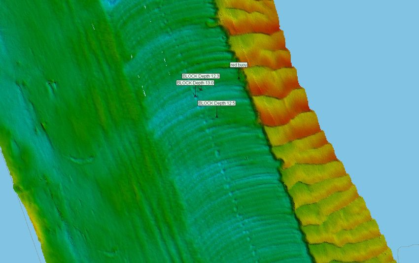
MILE 59.0 - SUBMERGED OBSTRUCTION/CHANNEL SURVEY - UPDATE
Submerged concrete blocks have been reported in the vicinity of Mile 59.0, LDB. These underwater obstructions could impact the left descending
side of the channel. Water depths over the top of these obstructions is approximately 11 feet, at minimum pool. Attached as an enclosure is the
latest USACE St. Louis District survey of the area. These obstructions are unmarked. Mariners are urged to exercise caution in the area.
LNM: 08-21
MILE 44.3 - CHANNEL CONDITION
Thick ice has built up in the vicinity of Mile 44.3. Conditions in the area are rapidly deteriorating with 95 percent ice coverage. Mariners are advised
against navigating through this area.
LNM: 07-21
MILE 26.5 - CHANNEL CONDITION
Shoaling has been reported in the vicinity of Mile 26.5, mid-channel. Mariners are urged to exercise caution in the area.
LNM: 06-21
KANAWHA RIVER
MILE 58.5 - PIPELINE REPAIR
Continuing until approximately March 12, 2021, Amherst Madison will conduct pipeline repair in the vicinity of Mile 58.5. The contractors floating
plant will consist of the M/V TOM COOK and a crane barge. Work will be conducted from 7:00 a.m. to 5:00 p.m., Monday through Saturday. The
M/V TOM COOK will monitor VHF-FM Channel 13 or 16. During non-working hours, the floating plant will be moored at the worksite and lighted
accordingly. Mariners are urged to transit the area at their slowest safe speed to minimize wake and proceed with caution.
LNM: 07-21
MILE 31.1 - L/D CLOSURE - UPDATE
On March 10, 2021, from 7:00 a.m. until 4:00 p.m., the Winfield L/D in the vicinity of Mile 31.1, will be closed for repairs. Mariners may contact the
lockmaster via VHF-FM Channel 13, for additional information.
LNM: 08-21
LOWER MISSISSIPPI RIVER
MILE 866.5 - CHANNEL CONDITION
Significant shoaling has been reported in the vicinity of Mile 866.5. The navigation channel width has been reduced to approximately 900 feet.
Mariners are advised to favor the can buoy line in the area and transit with caution.
LNM: 04-21
MILE 813.0 - CHANNEL CONDITION
Shoaling has been reported in the vicinity of Mile 813.0, approximately 400-500 feet inside the nun buoy line. Mariners are urged to exercise caution
in the area.
LNM: 06-21
MILE 772.0 - MILE 768.0 - CHANNEL CONDITION
Extreme shoaling has been reported between approximate Miles 772.0 and 768.0, inside the navigation channel, on the RDB. Mariners are advised
to favor the nun buoy line and transit as far off the RDB, as is safe. One-way traffic is advised through the area. Mariners are requested to transit
the area at their slowest safe speed and to proceed with caution, giving down-bound traffic the right of way. Mariners are requested to contact
U.S. Coast Guard Sector Lower Mississippi River via VHF-FM Channel 16 or at (866) 777-2784, to report areas of shoaling, hazardous conditions or
missing aids to navigation.
LNM: 40-20
MILE 757.0 - MILE 756.0 - AIDS TO NAVIGATION
Multiple nun buoys have been reported missing between approximate Miles 757.0 and 756.0. Mariners are urged to exercise caution in the area.
LNM: 07-21
MILE 720.0 - MILE 719.0 - CHANNEL CONDITION
Shoaling has been reported between approximate Mile 720.0 and 719.0. Mariners are urged to exercise caution in the area.
LNM: 04-21
Page 15 of 20 LNM: 08/21
Coast Guard District 8-MRS 24 February 2021MILE 719.0 - AIDS TO NAVIGATION
Multiple can buoys have been reported missing in the vicinity of Mile 719.0. Mariners are urged to exercise caution in the area.
LNM: 04-21
MILE 596.0 - RIP-RAP PLACEMENT
Continuing until March 1, 2021, a marine contractor is installing rock rip rap by barge in the vicinity of Mile 596.0, LDB and RDB. Loaded and empty
rock barges will be temporarily moored in the area. Work will be performed during daylight hours only, 7-days per week. The M/V BARBARA ANN will
be on scene and will monitor VHF-FM Channel 13 or 72. Mariners are urged to transit the area at their slowest safe speed to minimize wake and
proceed with caution after passing arrangements have been made. For up-to-date information, mariners can contact Darwyn Jarrell at (504) 835-
0303.
LNM: 43-20
MILE 592.5 - CHANNEL CONDITION
Shoaling has been reported in the vicinity of Mile 592.5, RDB. Mariners are urged to exercise caution in the area.
LNM: 04-21
MILE 585.0 - SUNK BARGE
A sunk work barge has been reported in the vicinity of Mile 585.0, close to the public boat ramp, outside of the navigation channel, Rosedale Harbor.
The barge reportedly has 29 feet of water over the top, as of December 9, 2020 and is reportedly unmarked. Mariners are urged to exercise
caution in the area.
LNM: 51-20
MILE 540.1 - CHANNEL CONDITION
Shoaling has been reported in the vicinity of Mile 540.1, near the nun buoy line. Mariners are urged to transit the area with caution.
LNM: 50-20
MILE 466.0 - AIDS TO NAVIGATION
Multiple buoys have been reported missing in the vicinity of Mile 466.0. Mariners are urged to exercise caution in the area.
LNM: 07-21
MILE 304.0 - L/D TEMPORARY DELAYS
Continuing until approximately March 1, 2021, intermittent delays to navigation, of up to 12-hours, may be experienced at the Old River L/D in the
vicinity of Mile 304.0, between 7:00 a.m. and 6:00 p.m. The Lockmaster, Mr. Anthony T. Lindsly can be reached at (225) 492-3333, for up-to-date
information. The point of contact at the USACE New Orleans Office is Russell Beauvais at (225) 492-2169.
LNM: 05-21
MILE 304.0 - L/D RESTRICTIONS
Continuing until approximately May 1, 2021, tows are to enter the lock wall at a DEAD SLOW speed, tows will be restricted to a length no more than
1,100 feet and will line up along the floating guidewall before proceeding into the lock’s chamber. Two line-handlers (with life vests) and bumpers
are required when approaching and exiting the lock. Vessels must be moored by the bow and stern to the floating timber-heads. The Lockmaster,
Mr. Anthony T. Lindsly can be reached at (225) 492-3333, for up-to-date information. The point of contact at the USACE New Orleans Office is
Russell Beauvais at (225) 492-2169.
LNM: 01-21
MILE 304.0 - L/D CLOSURES
Continuing until March 9, 2021, the Old River L/D in the vicinity of Mile 304.0, will periodically be closed to navigation for up to 4-days at a time, to
perform operational load tests on the newly installed Emergency Bulkhead Lowering Carriage Machinery. Navigation will be allowed to pass
between load test cycles. The maximum estimated time for a load test cycle will be 4-days. Lock personnel will do all that is possible to minimize
the impacts to the navigation industry. The load tests must be performed to assure that the New Emergency Bulkhead Lowering Carriage
Machinery is fully operational in the event of an actual operational emergency. Mariners are urged to transit at their slowest safe speed to minimize
wake and proceed with caution when the lock is periodically opened to clear the queue. The Lockmaster, Anthony Lindsly, can be reached at (225)
492-3333 (Office) or (504) 407-4434 (Cell). The point of contact for the USACE New Orleans District is Russell Beauvais, Operations Manager, (225)
492-2169 (Office) or (225) 202-3851 (Cell).
LNM: 07-21
MILE 301.3 - STONE PLACEMENT
Continuing until approximately February 27, 2021, a U.S. Government Contractor will be placing upper bank stone in the vicinity of Mile 301.3, RDB.
The contractors floating/land plant will consist of the M/V MISS NINA, a spud barge with a hydraulic backhoe, an office barge and various material
barges and dozers working along the bank. Work will be conducted 10-hours a day, during daylight hours, 7-days a week. During non-working
hours, the contractors floating plant will be staged along the river bank, outside of the channel along the RDB. The M/V MISS NINA will monitor
VHF-FM Channel 13 or 16 or at (301) 452-0183 or (318) 452-2403. Mariners are urged to transit at their slowest safe speed to minimize wake and
proceed with caution after passing arrangements have been made. The point of contact with the USACE New Orleans District is John Page at (337)
291-3015.
LNM: 07-21
UPPER MISSISSIPPI RIVER
MILE 699.8 - BRIDGE MAINTENANCE
La Crosse Railroad Drawbridge; Sheerfence repair is ongoing from 7:00 a.m. until 5:00 p.m., daily, through February 2021. During this time, the
left descending navigation channel will be impassable, due to a floating work-plant in the area. Mariners may contact M/V JOHN J. MANNING via
VHF-FM Channel 13, 14 or 16, for more information.
LNM: 52-20
MILE 522.5 - L/D CLOSURE
Page 16 of 20 LNM: 08/21
Coast Guard District 8-MRS 24 February 2021MILE 522.5 - L/D CLOSURE
Continuing until noon, March 15, 2021, L/D 13 in the vicinity of Mile 522.5, will be closed for maintenance. During this closure, mariners are
requested NOT to tie up on the guidewalls. Mariners may contact L/D 13 via VHF-FM Channel 14 or at (815) 589-3313, for additional information
and assistance.
LNM: 46-20
MILE 493.3 - L/D CLOSURE
Continuing until noon, March 15, 2021, L/D 14 in the vicinity of Mile 493.3, will be closed for maintenance. During this closure, mariners are
requested NOT to tie up on the guidewalls. Mariners may contact the lock via VHF-FM Channel 14 or at (309) 794-4357, for additional information.
LNM: 46-20
MILE 485.81 - BRIDGE REPLACEMENT
I-74 Replacement Bridge; Superstructure work is ongoing in the main channel. At times horizontal clearance may be reduced to 350 feet. A helper
boat is available by contacting M/V KAREN RENEE’ HAMM via VHF-FM Channel 13 or 16, or by telephone, from 6:00 a.m. until 6:00 p.m., at (309)
361-1047 and from 6:00 p.m. until 6:00 a.m., at (309) 299-4213.
LNM: 15-20
MILE 483.0 - L/D CLOSURE
Continuing until noon, March 15, 2021, L/D 15, in the vicinity of Mile 483.0, will be closed for repairs. During this closure, mariners are requested
NOT to tie up along the guidewalls. Mariners may contact the lock at (309) 794-5266 or via VHF-FM Channel 14, for assistance.
LNM: 46-20
MILE 481.4 - BRIDGE REPAIR
Cresent Railroad Bridge; The right descending span will be blocked by a construction barge. The barge will occupy the span 24-hours a day, until
further notice. Mariners are advised to only use the left descending navigation span.
LNM: 52-20
MILE 384.8 - MILE 367.2 - AIDS TO NAVIGATION
The following aids to navigation have been withdrawn for the navigation season and replaced with unlighted buoys:
Dutchman Island Lighted Buoy (LLNR-15395), in the vicinity of Mile 384.8,
Sunken M/V John Paul Lighted Buoy (LLNR-15435), in the vicinity of Mile 378.4 and
Waggoner PT Lighted Buoy (LLNR-15475), in the vicinity of Mile 367.2.
LNM: 49-20
MILE 364.2 - L/D CLOSURE
Continuing until noon, March 15, 2021, L/D 19, in the vicinity of Mile 364.2, will be closed for maintenance. During this closure, towboat operators
are requested NOT to tie up on the guidewalls. Mariners may contact the lock via VHF-FM Channel 14 or at (319) 524-2631, for additional
information.
LNM: 48-20
MILE 324.9 - L/D CLOSURE
Commencing 7:00 a.m., March 8, 2021 and continuing until 5:00 p.m., March 12, 2021, L/D 21 in the vicinity of Mile 324.9, will be closed for repairs.
During this closure, mariners are urged NOT to tie up on the guidewalls. Mariners may contact L/D 21 at (217) 222-0918 or VHF-FM Channel 14, for
the latest information.
LNM: 04-21
MILE 301.2 - L/D CLOSURE
Continuing until 5:00 p.m., February 26, 2021, L/D 22 in the vicinity of Mile 301.2, will be closed to navigation. During this closure, mariners are
requested NOT to tie up on the guidewalls. Mariners may contact the L/D 22 via VHF-FM Channel 14 or at (573) 221-0294, for additional
information.
LNM: 07-21
MILE 241.4 - L/D CLOSURE
Continuing until 6:00 p.m., March 31, 2021, L/D 25 in the vicinity of Mile 241.4, will be closed for repairs. All navigation interests should be alert for,
and abide by, any special instructions that may be issued by the lockmaster.
LNM: 51-20
MILE 185.5 - NAVIGATION OBSTRUCTIONS
Navigation obstructions, consisting of embedded metals, have been reported protruding from the lock walls, L/D 27 (auxiliary chamber side) in the
vicinity of Mile 185.5. Tows should exercise caution and stay off the bullnose, to avoid the protruding metal. Mariners should be alert for, and abide
by, any special instructions that may be issued by the lockmaster.
LNM: 06-21
MILE 185.5 - L/D RESTRICTIONS - UPDATE
Continuing until further notice, L/D 27 in the vicinity of Mile 185.5, has imposed 89-foot width restriction in the auxiliary chamber, due to ice
accumulation. The main chamber is open to navigation without restrictions. All navigation interests should be alert for, and abide by, any special
instructions that may be issued by the lockmaster.
LNM: 08-21
MILE 183.2 - BRIDGE CONSTRUCTION
Merchants Railroad Bridge; Work barges continue excavating around both left and right descending navigation piers and the right descending pier
of the center span. Work barges should not encroach more than 65 feet into the navigation channel, at any time. For work barge locations,
Page 17 of 20 LNM: 08/21
Coast Guard District 8-MRS 24 February 2021MILE 183.2 - BRIDGE CONSTRUCTION
mariners are encouraged to contact the onsite work boat M/V KATHERINE OHARA via VHF-FM Channel 6 or 16 or by phone at (217) 248-9077.
LNM: 49-20
MILE 179.2 - BRIDGE MAINTENANCE
Douglas MacArthur Bridge; Two suspended platforms are located in the center navigation span. Each platform measures 9 feet wide and hang 5
feet below low steel. One platform is located 60 feet channelward of the right descending pier and the other platform is located 120 feet
channelward of the left descending pier. There are also 3 platforms located at various locations in the Illinois span. Mariners are urged to transit
the bridge with caution.
LNM: 32-19
MILE 46.1 - CHANNEL CONDITION
Heavy ice flows have been reported in the vicinity of Mile 46.1, Grays Point. Tows transiting north-bound through the area are reportedly
experiencing difficulties transiting through the area. Mariners are urged to exercise caution in the area.
LNM: 08-21
MILE 46.03
MILE 45.95 - AIDS TO NAVIGATION
Two can AIS aids to navigation have been relocated based on dredging performed at Grays Point, at Mile 46.03 and Mile 45.95. The new positions
are 37-14-55.98996N 089-27-36.94152W and 37-14-53.36688N 089-27-34.36818W. Mariners are urged to exercise caution in the area.
LNM: 08-21
MILE 7.5 - BRIDGE LIGHTING REMOVAL/ALTERNATE SPAN
I-57 Bridge; Mariners are advised that the green lights marking the alternate span, have been permanently extinguished. Mariners are advised to
use the main channel span until further notice.
LNM: 44-20
MISSOURI RIVER
MILE 615.9 - BRIDGE LIGHTING
I-480 Bridge; The bridge owner is replacing all the navigation lights on the bridge, through March 10, 2021. There will be no functioning navigation
lights during the replacement of the new navigation lights.
LNM: 49-20
OHIO RIVER
MILE 3.6 - TEMPORARY LIGHTED DANGER BUOYS
Mascaro Construction Co., LP., has installed four (04) Temporary Lighted Danger Buoys with White flash characteristic Fl 2.5s, to mark a turbidity
curtain around the perimeter of the construction area located at the Allegheny County Sanitary Authority (ALCOSAN), in the vicinity of Mile 3.6, RDB.
The Temporary Lighted Danger Buoys were installed in the following approximate positions:
40-28-42.82N 080-02-51.39W,
40-28-47.97N 080-02-55.63W,
40-28-55.90N 080-03-03.99W and
40-29-00.91N 080-03-09.91W.
Any questions, inquiries or navigation safety concerns, should be directed to Mascaro Construction, Mr. Steve Senchesen, via telephone at (412)
321-4901 or email to ssenchesen@mascaroconstruction.com, or you may contact U.S. Coast Guard Sector Ohio Valley at (502) 779-5422 or via
email at: STL-PF-SECOHVCommandCenter@uscg.mil. Mariners are advised to exercise caution in this vicinity and to completely avoid navigating
outside of the navigable channel in the area.
LNM: 46-20
MILE 75.5 - BRIDGE CONSTRUCTION
New Wellsburg Bridge; Trestles extend out from both left and right descending banks, during construction of new piers. A 814-foot navigational
horizontal clearance remains. The onsite workboat M/V TAYLOR NICOLE can be reached via VHF-FM Channel 19, for further information. Mariners
are advised to transit the area with caution.
LNM: 03-20
MILE 452.0 - MILE 454.0 - SHORE SIDE DEMOLITION/SAFETY ZONE
On February 26, 2021, from 9:30 a.m. until 10:30 a.m., shore side demolition of a facility will be conducted between approximate Miles 452.0 and
454.0. The COTP Ohio Valley has established a temporary Safety Zone to facilitate this operation. Vessels are prohibited from transiting this area,
for the duration of the operation. Mariners may contact the event manager at (313) 215-8251, for additional information.
LNM: 07-21
MILE 471.2 - BRIDGE MAINTENANCE
Brent Spence Highway Bridge; A suspended containment system is being installed following the contour of the bridge and will reduce the vertical
clearance approximately 3 feet. Mariners are advised to transit the bridge with caution.
LNM: 07-21
MILE 595.7 - AID TO NAVIGATION
A can buoy has been reported not properly marking the channel, mid-channel, in the vicinity of Mile 595.7. Mariners are urged to exercise caution in
the area.
LNM: 02-21
MILE 644.7 - OFFLOAD OPERATION
Continuing until April 2, 2021, during daylight hours, an equipment offload operation will be conducted at a facility in the vicinity of Mile 644.7.
Equipment will be offloaded from barges nosed into the bank using cranes or will be driven off the barge directly onto the bank. An additional spud
Page 18 of 20 LNM: 08/21
Coast Guard District 8-MRS 24 February 2021You can also read