KRUGER BIG 5 GEOLOGY SAFARI* - Wes Gibbons 2019 - Barcelona Time Traveller
←
→
Page content transcription
If your browser does not render page correctly, please read the page content below
KRUGER BIG 5 GEOLOGY SAFARI*
                                             Wes Gibbons 2019

This guide describes a self-drive tour of Kruger National Park that provides the opportunity not only for
abundant wildlife viewing but also to learn about the geology underlying the scenery of the savanna. Many
people seem to visit Kruger obsessed with the intention of photographing the “Big 5” (buffalo, elephant,
leopard, lion and rhinoceros), completely unaware that there is another Big 5 waiting to be enjoyed in the rocks.
So here it is: a Holiday Geology Guide to Kruger National Park. It is something of an adventure. If you have never
visited Kruger before, then you are in for a treat. The route has been carefully chosen to maximise wildlife and
scenic geology viewing, although note that this is mostly car seat geology as you can only leave your vehicle in a
very few designated areas, and then at your own risk. Kruger is a zoo in which the humans are restricted to
confined spaces, not the other animals.
Rock exposure is generally poor across the deeply weathered and magnificently ancient African land surface,
although there are notable exceptions in some parts of the park. The varied and beautiful landscapes found in
the park however are a direct expression of the underlying geology which impacts on the scenery, soils, ecology
and therefore wildlife distribution. The rocks range from some of the oldest found on planet Earth to relatively
young sediments and volcanic lavas produced when Africa split from Antarctica during Jurassic supercontinental
break-up and the world’s oceans as we know them began to form. The west side of Kruger is underlain by
Precambrian rocks, most of which belong to the ancient nucleus of the African continent (the “craton”) and are
over 3 billion years old. In contrast, the eastern side of the park exposes Mesozoic Era Jurassic sandstones,
basalts and rhyolites that are a little less than 200 million years old. The sharp line between these fundamentally
different two geological units, Precambrian versus Mesozoic, runs north to south for 330km from Pafuri to
Crocodile Bridge.
This guide is written for the general tourist rather than the professional geologist. Your geological understanding
will gradually develop as you drive the route and at the end of the guide you will understand how you have seen
and learnt about the Kruger Geological Big Five. Thus you are not expected to make an effort to learn geology
before arriving: it will just happen.

Arrival and Departure Logistics
The route enters the park at Phalaborwa Gate in the central west, heads north to the border with Zimbabwe,
then turns back south to cross the full length of Kruger to the Crocodile River at Malelane Gate. The journey
involves a minimum of 7 nights in the park base camps operated by Sanparks, accommodation in which must be
booked in advance (https://www.sanparks.org/bookings/). The accommodation is simple but comfortable
enough, especially if you choose the more expensive options such as perimeter fence bungalows with verandas
and, in Punda Maria, the “luxury” safari tents.

For those arriving by air, there are three airports on the west side of the park, namely Phalaborwa, Hoedspruit
(Eastgate) and Mbombela/Nelspruit (Kruger), and one inside the park (Skukuza). There is also, of course, the O.
R. Tambo international airport in Johannesburg, although this involves a long, tiring drive (not good after a long,
tiring flight) that requires you to find somewhere to stay overnight before entering the park. For those hiring a
car at the airport, choose a vehicle with high ground clearance: the route described is mostly on good tarmac

*
 Cite as: Gibbons, W. 2019. Holiday Geology Guide to Kruger. http://barcelonatimetraveller.com/wp-
content/uploads/2018/10/Kruger-Big-5-Holiday-Geology.pdf
BARCELONA TIME TRAVELLER COMPANION GUIDE

roads and we have tried to avoid using dirt roads with poor surfaces, but in places the terrain can be quite
rough, especially in bad weather and times of flood. An ideal plan would be to fly into Phalaborwa or Hoedspruit
airports and out from Mbombela/Nelspruit (Kruger) or Skukusa airports.

Phalaborwa town makes an excellent entry point into the park and conveniently has overnight accommodation
options, a Spar supermarket, bottle shop and Total filling station just west of the gate: stock up with plenty of
water, beer and snack food before entering Kruger. Plan to pass through the Phalaborwa Gate in the morning,
and absolutely no later than 14.00. Once in the park relax and take it easy, always obeying the speed limits and
being cautious with the animals, especially the elephants who, you will quickly learn, demand respect. Be aware
that travelling distances inside the park usually take longer than expected: calculate an average of 25kph
maximum on the surfaced roads.

The Route
The route plan suggested here has been tried and tested and it works as long as the rivers are not in flood and
you watch the clock as the day progresses. You may, of course, wish to make your own changes/additions, but
be careful with your planning. Some of the dirt roads (such as for example the long and isolated S50 running
south from Shingwedzi are (in 2019) treacherously corrugated and excruciatingly slow going if your vehicle is
more suited to urban travel than the bush. Such roads eat up the hours at an alarming rate: you have to be back
at base camp before they close before nightfall. It is always, in any case, best to start the day early, getting up at
or soon after sunrise.

The route described in this guide is subdivided into 7 days as summarised below:

                                  Day 1: Phalaborwa Gate to Mopani Rest Camp

                                     Day 2: Mopani to Punda Maria Rest Camp

                           Day 3: Northern border around Pafuri; return to Punda Maria

                                   Day 4: Punda Maria to Shingwedzi Rest Camp

                                      Day 5: Shingwedzi to Olifants Rest Camp

                                       Day 6: Olifants to Skukuza Rest Camp

                                     Day 7: Skukuza to Berg-en-Dal Rest Camp

Day 1: Phalaborwa to Mopani Rest Camp

The town of Phalaborwa lies in the flat lowveld some 350m above sea level and around halfway between the
great Drakensberg Escarpment to the west and the Lebombo Hills that run along the South African border with
Mozambique. The town is dominated by a huge mine (not seen on the approach to Kruger) from which a wide
range of minerals and elements have been extracted in modern times, notably phosphates (since 1934) and
copper (since 1966). This is one of the largest open pit copper mines in the world, measuring nearly 2km across.
Copper- and iron-rich surface ores have been mined and smelted by local people in this area for well over a
thousand years.

2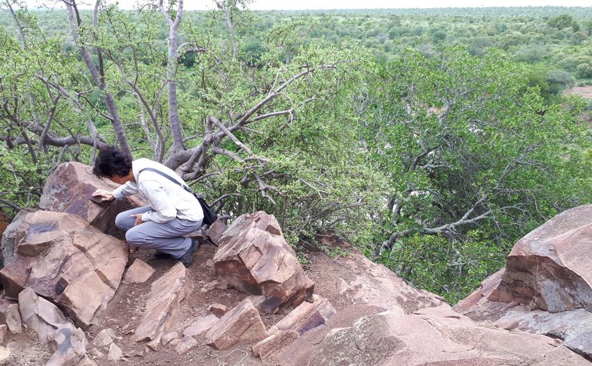
BARCELONA TIME TRAVELLER COMPANION GUIDE

       PAFURI                                                                           ORPEN GATE
       GATE
                                           DAY    1:   PHALABORWA TO MOPANI
                                           DAY    2:   MOPANI TO PUNDA MARIA
                                           DAY    3:   PUNDA MARIA AND PAFURI
                                           DAY    4:   PUNDA MARIA TO SHINGWEDZI
            PUNDA
            MARIA
                       Day 3               DAY    5:   SHINGWEDZI TO OLIFANTS
                                           DAY    6:   OLIFANTS TO SKUKUZA                         Day 6
                                           DAY    7:   SKUKUZA TO BERG-EN-DAL
    PUNDA
    MARIA                                                                             KRUGER
    GATE                                                                               GATE
                                                                    PHABENI
                                                                    GATE
                                                                                                  SKUKUZA

                              Day 4                                NUMBI GATE
                                                                                                           LOWER
                                                                                                           SABIE
                              SHINGWEDZI                                         PRETORIUSKOP

                Day 2                                                             Day 7
                                                                                  BERG-EN-
                                                                                  DAL                      CROCODILE
                                                                                                            BRIDGE

                                                                                                MALELANE
                                                                                                  GATE

                           MOPANI
                                        Day 5
       N                                                                         KRUGER GEOLOGICAL
                      Day 1                                                           BIG FIVE
                                         LETABA
                                                                                     LEBOMBO RHYOLITES
                                                                                                     182 my
                                                                                     KAROO BASALTS

                                                                                     KAROO SEDIMENTS
             PHALABORWA GATE
                                                       OLIFANTS                     time gap (unconformity)
                                                                                ~~~~~~~~~~~~~~~~~~~~~~~

                                                                                     SOUTPANSBERG
                                                                                     GROUP
                                                                                     1800 my

                                                          SATARA

                      ORPEN GATE                            Day 6
                                                                                          KAAPVAAL CRATON
                                                                                           up to 3500 million years

           40 km

            Simplified geological map of Kruger Park with 7-day route described in this Holiday Geology Guide.

3
BARCELONA TIME TRAVELLER COMPANION GUIDE

Register your visit at the Information Centre just outside the gate, check that there is no flooding at the Letaba
River crossing on the H14, and buy a Kruger Park Map (that published in book form by Tinkers is perfectly
adequate: http://www.tinkers.co.za/). Enter the park though Phalaborwa Gate and head east on the H9 through
undulating mopane tree woodlands for 8km then turn right onto the gravel Sable Loop Road (S51) which runs
east of a lake created by the Sable Dam (built across the Mashangani River in 1972). After 2kms there is a track
on the right leading to a view over the reservoir. The main S51 track continues south to Sable Hide (on the right)
where you can emerge from your vehicle at your own risk and enter the protected hide with views across the
lake. The drainage here runs south into the Lepelle (Olifants) River.

From Sable Hide continue following the S51 loop track anticlockwise, driving over young sandy deposits and
turning north to pass excellent examples of small hills known as “koppies” on the way back to the H9. These hills
mark rocks that are more resistant to erosion, and they are commonly hard, massive and granite-like in texture
and form.

Koppie scenery on Sable Loop Road. Geomorphologically outstanding landforms such as these are known as “koppies”
(Afrikaans = little head), small versions of “inselbergs” (German= island mountain) or “monadnocks” (Indigenous North
American = smooth or isolated mountain). They gradually emerge as erosion proceeds, preferentially leaving the harder rock
standing proud from the softer surrounding ground. They typically comprise massive, relatively unfractured, bare rocks with
little or no soil cover. In Kruger they erode extremely slowly, just 2-3 mm every thousand years, and are thus eloquent
testimony to the vastness of geological time. They have been shaped over deep time to form familiar upstanding
navigational landmarks that encourage the development of local ecologies distinct from those in the surrounding
Mopaneveld.

4

BARCELONA TIME TRAVELLER COMPANION GUIDE

                          Impalas at base of syenitic koppie to the east of Sable Loop Road (S51)

Turn right into the H9 then, in
BARCELONA TIME TRAVELLER COMPANION GUIDE

Masorini Syenite. Syenite is a hard, massive, granite-like rock formed mostly of interlocking pale crystals of potassium
feldspar and less well defined black crystals of dark minerals (amphiboles, pyroxenes, and micas). This is a plutonic igneous
rock, crystallised deep underground at high temperatures and cooled slowly enough to allow large crystals to grow. The
Phalaborwa syenite is one of several circular satellite plug-like pipes that surround the copper mine of Phalaborwa. Both the
syenites and the rocks hosting the metal mineralisation at Phalaborwa (the “Phalaborwa Igneous Complex”) crystallised
from molten magma just over 2 billion years ago. This magma rose through the Earth’s crust to feed volcanoes erupting
high above but long since eroded away so that we can now view the deep magmatic plumbing system that once lay beneath
them. The Masorini syenite pipe has intruded and solidified within an ancient basement of even older rock that is more
weathered and therefore not exposed in the surrounding lower ground of the mopaneveld.

Drive back west on the H9 then north on the H14, passing the prominent syenite koppie of Shikumu (452m) on
the right. Twelve km from the H9 turn right into the dirt track leading to the Nandzana waterhole alongside the
Ngwenteni River. The sandy soils forming this part of Kruger are underlain by quartz-rich rocks (granites and
gneisses) that are rarely exposed. The commonest underlying rock type is the “Makhutswi Gneiss” which has
yielded an age of over 3 billion years (more precisely 3,228,000,000 years), placing it amongst some of the
oldest rocks known on Earth. We shall see exposed examples of similarly ancient gneissic basement in the Red
Rocks loop to be visited on Day 2.

Continue northeast on the H14, crossing the Ngwenyeni River which now runs to the right side of the road. Five
km northeast of the Ngwenyeni Bridge the H14 curves clockwise (right) from north to southeast across the flat
mopaneveld as it follows a prominent meander in the Ngwenyeni River. In this area the underlying rocks have
changed radically from more granitic compositions covered by sandy soils to dark, iron- and magnesium-rich
rocks known as the Timbavati Gabbro. The change from pale sandy quartz-rich ground on the Makhutswi Gneiss
to dark soils formed from the weathering of the gabbro is particularly obvious from the Google satellite map
which clearly marks how the gabbro outcrop forms a band running N-S and around 1-2km wide. We shall
observe exposures of the Timbavati Gabbro during the Red Rocks loop planned for Day 2.

The H14 continues ENE, back on the Makhutswi Gneiss outcrop as it crosses the Ngwenyeni River then curves
north to cross the Letaba River, a major water course that runs southeast across the park to join the Lepelle
River at the Lebombo Hills near the Mozambique border. After the Letaba crossing, the H14 winds for a further
5km across the gently undulating savannah with no rock exposures, which is a pity because here beneath the

6
BARCELONA TIME TRAVELLER COMPANION GUIDE

mopane trees are some very interesting rocks. Instead of quartz-rich Makhutswi Gneiss there is the “Murchison
Greenstone Belt” (MGB), a (geologically) famous zone of >3-billion-year old volcanic and sedimentary rocks that
can be traced west from here for over 100km. The MGB forms the northern boundary of the Makhutswi
Gneisses. A few kilometres further up the H14 we pass from the MGB on to more gneisses, but again there is no
sign of this on the road, and we shall have to content ourselves with waiting for the next day’s geology.

Just over 20kms from the Letaba River crossing, the H14 turns east then makes a sweeping gentle curve left
toward the north. Once a north-south orientation has been achieved you will see on the right a low rocky ridge
of brown sandstones. This sandstone belongs to the Clarens Formation and it marks the boundary between the
two fundamental different geological sides to Kruger Park: the ancient cratonic rocks to the west, and the much
younger Jurassic rocks to the east. The Clarens Formation sandstone is Lower Jurassic in age, a mere 185 million
years old or so.

The H14 crosses the Kaleka River after which the low ridge of Clarens Formation sandstone now lies on the left
and road curves across the flat mopaneveld typical of the Jurassic rocks that lie above the Clarens sandstones.
Two km after the Kaleka crossing the road curves southeast to reach the bridge over the Tsendze River. Here on
the right side of the river crossing are exposures of Jurassic rocks that can be seen to slope (“dip”) gently down
to the east: this is typical of the Jurassic succession. The easterly dip means that as you drive eastward so you
climb higher in the Jurassic rock succession. This is the law of superposition, with older rocks being covered
progressively by younger ones:

The study of … rock layers is known as “lithostratigraphy” and … it rests upon the fundamental premise that
younger rocks are deposited upon older ones as horizontally and laterally continuous beds. The idea was
expressed in the Dissertationis prodromus published in 1669 by the Danish scientist Nicolas Steno who is credited
with being one of the first to elucidate several of the defining principles of the science of stratigraphy (from The
Ninth Tale (Montserrat) in http://barcelonatimetraveller.com/).

7
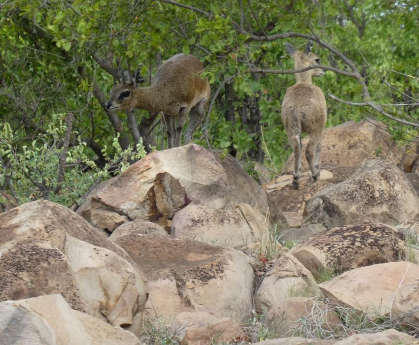
BARCELONA TIME TRAVELLER COMPANION GUIDE

A pair of klipspringer antelope on Clarens Formation sandstone exposed east of the H14 just before the Kaleka River
crossing. The monogamous klipspringer prefers rocky habitats where it is well camouflaged and lacks competitors, its
adaptation to the geology providing an ecological advantage that has ensured this animal has not entered the endangered
list.

Turn left into the H1-6 and drive 13km north across the Jurassic outcrop to the Mopani Rest Camp junction then
left to enter the camp. At the rest camp we have returned down the east-dipping Jurassic succession to reach
once again the Clarens Formation sandstone. The sandstones form a prominent ridge rising above the Pioneer
Reservoir which lies on low ground underlain by basement gneiss. It is possible to stay in a bungalow
overlooking the reservoir and with your own private exposure of Clarens sandstone.

8
BARCELONA TIME TRAVELLER COMPANION GUIDE

Clarens sandstone exposure in Mopani base camp. Pink-weathering sandstones of the Clarens Formation preserving
polygonal dessication cracks formed in a hot desert environment that covered much of Southern Africa in Lower Jurassic
times 185 million years ago. The east-dipping, hard sandstones form a prominent west-facing escarpment that overlooks
the lake produced by the Pioneer Dam below. The view is from Bungalow 101 (BD4V, Mopani Rest Camp) which not only has
its own private Clarens Formation exposure but also extensive views over the lake and beyond over the flat, low ground
underlain by cratonic basement gneisses to the west.

9
BARCELONA TIME TRAVELLER COMPANION GUIDE
Day 2: Mopani to Punda Maria Rest Camp
We recommend starting the day with a pre-breakfast animal-spotting 6km drive to the Pioneer Dam Lookout.
Drive back to the H1-6 then south for 2km to turn right onto the S142 which crosses the Tsendze River via a
concrete causeway sometimes guarded by hungry crocodiles. To the left are gently dipping exposures of Jurassic
basaltic rocks (Letaba Formation), but best not to leave the vehicle in order to examine them.
Causeway over the Tsendze River on S142 road, with adjacent crocodile waiting for breakfast. Basaltic rocks of the Letaba
Formation crop out in low exposures behind and to the left of the car.
After crossing the river the road curves right to pass the Shipandani Hide and Lookout over the Tsendze River
(right). In 200m pass a left fork and go straight on (west) for another 800m. Here the track passes from basaltic
to quartzitic (Clarens sandstone) soils (seen as colour contrast on Google maps) and turns right at a sign to
Pioneer Dam. In 100m you reach a fork where you stay left as the track loops clockwise and in 300m reaches the
Pioneer Dam Hide, on the outcrop of the Clarens Formation sandstones. Here we are back close to the
geological boundary between east (Jurassic) and west (cratonic) geological Kruger although, once again, the
basement gneisses are not exposed. After visiting the hide, continue following the clockwise loop, with views
north to the higher ground of the rest camp, and return by the outward route.
Zebra crossing on the drive back from
Pioneer Dam to Mopane Rest Camp,
looking east. Ahead lies the low, flat plain
of mopaneveld growing on Jurassic basalt,
beyond which rise the Lebombo Hills that
are formed of harder, more resistant rocks
overlying the basalt (and to be visited later
on the journey).
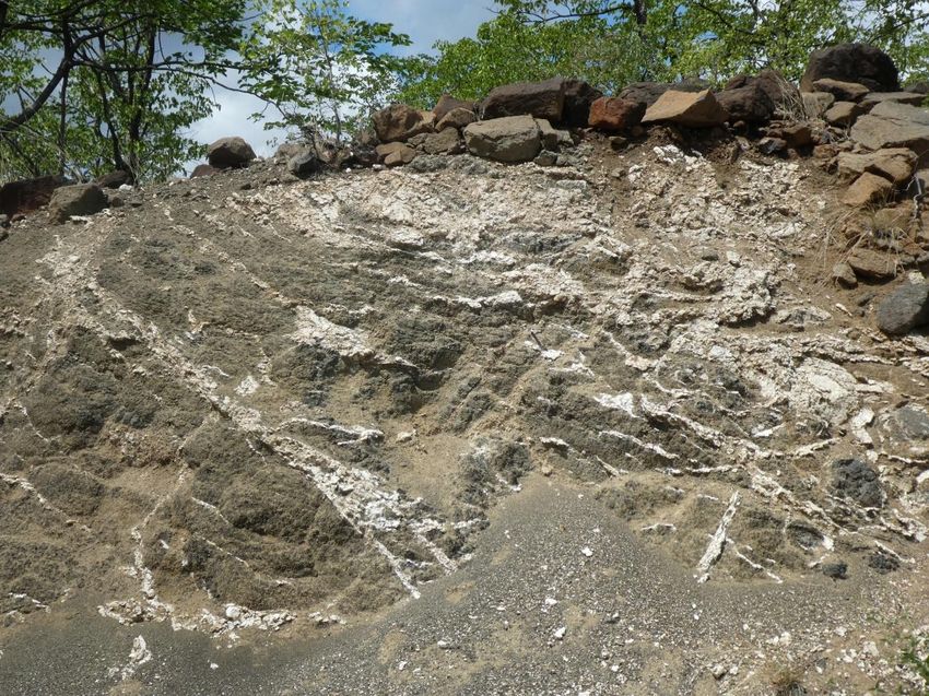
10BARCELONA TIME TRAVELLER COMPANION GUIDE The main drive of the day follows the H1-6 north from Mopani for 50km on a good road surface before entering the highlight: the 45km Red Rocks Loop on a dirt road (S52) that follows the Shingwedzi River and is usually full of wildlife (allow at least 3 hours for this loop). After this the route continues on good roads 30km north to Babalala picnic site then a further 42km northwest to the Punda Maria Rest Camp. Beware of speed traps, particularly in the last hour of the journey. The H1-6 north initially passes a series of koppies (such as Bowkers Kop) as it runs northwest over the basaltic then sandstone outcrop back on to the cratonic basement, crossing the Tropic of Capricorn and passing a series of waterholes such as Olifantsbad Pan. At 37km north of Mopani the H1-6 passes the S144 (right), by now heading north close to the basement gneiss/Clarens Fm boundary. Eight km north of the S144 turn left on to the Red Rocks loop road (S52) then in 1km turn right (signposted Red Rocks 4km) to reach the Red Rocks viewpoint. From here one can see the dark basaltic rocks of the Letaba Formation underlain by the pink-red Clarens Formation sandstones. View west from Red Rocks Lookout. The Shingwedzi River flows eastwards across the red outcrop of east-dipping Clarens Formation desert sandstones (top centre and right) and on to the overlying Letaba Formation basalts (brown rocks and soils on the left and foreground). The basalts were erupted from Jurassic volcanoes 182-3 million years ago, a moment in geological Deep Time when the desert environment of southeast Africa was transformed into a volcanic landscape which heralded the opening of the ocean between Africa and Antarctica. Riverbed potholes eroded into the Clarens sandstone have trapped sand particles containing heavy metals, leading to the discovery of alluvial gold here in the 1920’s. Continue driving south on the Red Rocks loop to a T junction with the S52 where you turn right and, after 1km, right again to cross the causeway over the Shingwedzi River. Here at last there are exposures of the ancient cratonic basement that underlies western Kruger. 11
BARCELONA TIME TRAVELLER COMPANION GUIDE

View east from the causeway over the Shingwedzi River at Red Rocks. The grey rocks in the foreground immediately
adjacent to the causeway form part of the cratonic basement of Africa and are over 3 billion years old. They are called the
Groot Letaba gneisses, a “gneiss” being a rock that has been transformed into new mineral crystals by high temperature
and pressure deep in the crust (a process called “metamorphism”, a word derived from the Roman author Ovid’s classic
poem Metamorphoses which begins “Of bodies changed into new forms I speak”).The most characteristic feature of such
gneisses is that the newly recrystallized minerals have been aligned by the metamorphic pressures so that they form layers,
as can be seen in this image (dipping steeply down to the left). In the background downstream are exposures of the
overlying Jurassic Clarens Formation red sandstones. The break in time between the ancient gneissic basement and the
Jurassic desert sandstones is over 2,800,000,000 years. Significant time gaps in rock sequences are known as
“unconformities”, and unconformities on Planet Earth don’t get much bigger than this one at the Groot Letaba/Clarens
boundary in the Shingwedzi river bed.

Drive back over the causeway to re-join the S52 and continue 9km further west on the south bank of the
Shingwedzi River to cross the Tshanga River tributary where there are exposures of the Timbavati Gabbro
(image below). Soon after this crossing turn left on to the road that runs south for 2km to the remote Tshanga
Lookout for great views over the lowveld. There are exposures of the Timbavati Gabbro in the rocky ridge near
the car park, but this is an unfenced area where predators are common, so fieldwork is discouraged.

12
BARCELONA TIME TRAVELLER COMPANION GUIDE

The gravelly bed of the Tshanga River underlain by grey exposures of the Timbavati Gabbro, dated as just over 1 billion
years old (around 1,111,000,000 years). Like the Phalaborwa Syenite 1 billion years before it, the Timbavati Gabbro is part
of another huge igneous province, this one known as the Umkondo Province. Magmatic rocks of a similar age are found over
an area of more than 2 million square kilometres in Southern Africa, and extend into North America (in those days Africa
and America formed part of a supercontinent called Rodinia). A gabbro is similar to syenite in that it cooled slowly from
molten magma, allowing crystals to grow that are large enough to be seen by the naked eye. However gabbro has a very
different chemistry, richer in iron and magnesium and with more dark minerals such as pyroxenes. This chemistry is
essentially the same as that of basalt so that the ecozone characteristic of the gabbro is similar to that found on the Jurassic
basalts further east. Inset lower right: A close-up of the gabbroic texture in a rock from Tshanga Lookout. Gabbro (and
basalt) mineralogy is dominated by crystals of black pyroxene and white feldspar.

Return to the S52 and, assuming the river is not in flood (the northeastern exit near the H1-6 junction involves
another causeway river crossing), turn left and continue the loop clockwise to cross the river by another
causeway (more Timbavati Gabbro) and then turn back east, following the north bank back east for 28km to
rejoin the H1-6.

13
BARCELONA TIME TRAVELLER COMPANION GUIDE

                                        Warthogs on the S52 Red Rocks Loop

               Following the S52 for 28km on the north side of the Shingwedzi River can be slow going….

Turn left on to the H1-6, pass the turnoff to the Shingwedzi Base Camp (to be visited on the return journey) and
cross the Shingwedzi River, by now greatly broadened by the addition of the Mophongolo River flowing in from
the northwest. Continue northwest for another 35km across the flat plain of the basaltic Letaba Formation
outcrop to reach the comfort stop of Babalala on the left at the S56 junction. After this, continue north for a
further 21km on the H1-7 to turn left into the H13-1, with the prominent hill of Dzundziwini rising to the south
(left): we have by now left behind the monotonous basaltic soils and entered the different geology of this
northwestern end of the park around Punda Maria. In a further 16km, turn right to reach Punda Maria Rest
Camp in 4km. The rest camp is built on the southern slopes of a prominent east-west ridge (Dimbo Hill) which
can be admired from the short “flycatcher” walking trail inside the camp. This ridge forms the eastern end of the
Soutpansberg (Salt Pan Mountain) Range, an area famed for its reptile diversity.

14
BARCELONA TIME TRAVELLER COMPANION GUIDE
The geology of the area around Punda Maria is dominated by sandstones belonging to the Soutpansberg Group.
These sediments were deposited by rivers flowing around 1,900 million years ago across a fault-bounded basin
and so they lie unconformably upon the >3-billion-year-old gneiss we have seen to the south in the Red Rocks
loop. Despite the fact that the Soutpansberg sediments are so old, they are remarkably well preserved and
commonly show original sedimentary structures such as ripple marks, many examples of which can be seen in
the paving stones used around the camp.
Ancient ripple marks preserved in a paving stone used in the roadway leading to the Safari Tent site in Punda Maria. The
ripples were produced by rivers draining an east-west orientated low-lying area (“Soutpansberg Basin”) produced by fault
movements in this area around 1,900 million years ago. They became preserved in the geological record during the later
hardening (lithification) of the sandstone.
Today we have seen the Jurassic Clarens Formation sandstone (185 million years) lying unconformably above
the Groot Letaba Gneiss (>3 billion years). The Clarens Formation was deposited across a huge desert area
similar in size to the modern Sahara. It is curious how, around 1,700 million years before the Clarens desert,
similar sandstones in another arid African sedimentary land basin were being deposited on the older gneissic
basement (Soutpansberg Group on Groot Letaba Gneisses).This repetition of similar geological events is
testimony to the incredible stability of the African craton and, of course, to the immensity of geological time:
…..In 1858 George Julius Poulett Scrope publishes his seminal work on the volcanoes of the Auvergne and yells to
his readers the revelation of Deep Time: “The leading idea which is present in all our researches, and which
accompanies every fresh observation, the sound of which to the ear of the student of Nature seems echoed from
every part of her works, is—Time!—Time!—Time!”….. From: Barcelona Time Traveller: Twelve Tales
http://barcelonatimetraveller.com/
15BARCELONA TIME TRAVELLER COMPANION GUIDE Day 3: Punda Maria to Pafuri Today we visit the far north of Kruger National Park, including the geographic triple point on the Limpopo River at Crooks Corner where South Africa meets Zimbabwe and Mozambique. It is a remote drive across rolling mopane forest, less frequented by tourists than in the south of the park, and arrives at the sandy alluvial plain alongside the Luvuvhu and Lipopo rivers at Pafuri, a riverine area with abundant wildlife, before returning to Punda Maria. Start the day with an early morning safari self-drive through the sandveld by following the 25km Mahonie Loop dirt road (allow at least 2 hours: alternatively do this at the end of the day, or even tomorrow morning). Shortly after exiting Punda Maria Rest Camp turn left on the S99 dirt track which loops anti-clockwise around the prominent ridge of Precambrian Soutpansberg Group sediments (for the stratigraphic enthusiast, these rocks belong to a subdivision of the Soutpansberg Group called the Wyllie’s Poort Formation). The S99 soon turns northwest (left) as it runs through a broad valley with the Punda Maria east-west ridge of Soutpansberg Group sediments now to the south. There is no exposure of the underlying sandstones as the road heads west through the sandveld and leaves the stream system draining south into the Shingwedzi River to enter that which drains northeast into the great Limpopo River. Around 10km from Punda Maria the track turns south through the gap in the hills offered by the north-draining Matukwala River (a tributary of the Luvuvhu River which defines the edge of Kruger Park as it drains northeast into the Limpopo). There are occasional exposures of the brown-weathering Wyllie’s Poort quartzitic sandstone along the roadside as the track cuts south then turns back east to follow the southern side of the ridge leading to Punda Maria. Exposures of brown-weathering Wyllie’s Poort Formation sandstone alongside the S99 15km anticlockwise from Punda Maria Rest Camp. The layers (“beds”) of brown-weathering sandstone dip gently to the north, a rock structure that favours the development of steep south-facing “scarp” slopes (such as that behind the rest camp) and gentler north-facing “dip” slopes. The sandy soils on these rocks are well drained and favour the growth of drought-resistant trees such as the corkwoods. 16
BARCELONA TIME TRAVELLER COMPANION GUIDE

Fresher surfaces of the Wyllie’s Poort sediments reveal white (quartz) and pink (iron oxides such as hematite) minerals
cemented into a hard ferruginous, quartzitic sandstone. Note how the weathering is only skin deep, as expressed by the
brown surfaces where the red iron oxide has altered to brown, hydrated iron oxide minerals (such as limonite and goethite).

Rejoin the H13-2 near the Punda Maria rest camp and (unless a comfort/breakfast break is needed back at the
camp) turn right then left on to the H13-1 which runs southeast then east, with the Wyllie’s Poort sandstone hill
of Dzundzwini on the right (note that the S60 dirt road connecting the H13-2 to H1-8 offers a scenic shorter
route but, in 2019 at least, the surface was so bad that it was much slower going). The H13-1 crosses back on to
the Jurassic succession. At the T junction with the H1-7 and H1-8, by now back on the flat basaltic plains that
characterise the Letaba Formation, turn left and head north for 13km to the S61 (left). Here we are close to the
base of the Letaba Formation basalts, so by following the S61 west we cross back on to the Clarens Formation
sandstone outcrop (apparent on the Google satellite map). Follow the S61 west for
BARCELONA TIME TRAVELLER COMPANION GUIDE

Elephant crossing the Clarens Formation sandstone outcrop on the way to the Klopperfontein waterhole. In the area
between Punda Maria and Pafuri the Clarens sandstone features prominently to the west of the H1-8, in places forming
koppies and river gorges.

Thirteen km from Klopperfontein turn left to visit the Nkovakulu waterhole outlook before returning to the H1-
8. Over the next 10km the H1-8 runs north then northeast as it joins the western side of the Thambyi River
valley, with the scenery becoming more undulating and forested as the road descends towards the Luvuvhu
River, passing low exposures of weathered basalt. Two km before the H1-8 river crossing, the S64 (“Nyala
Drive”) dirt road leads off left (northwest) towards the historical site of Thulamela. The 5km drive to the south
bank of the Luvuvhu River often reveals wildlife (such as nyala) but access to the Thulamela site must be booked
in advance at Punda Maria as armed guard accompaniment is needed for protection against the carnivores.
Upstream from here the Luvuvhu River snakes through the remote, inhospitable country of the Lanner Gorge.

The Thulamela stone citadel in northern Kruger lies on Clarens Formation desert sandstones overlooking a tributary gorge of
the Luvuvhu River. It was reportedly occupied from c.1240-1700AD and at times contained an estimated 2000 people
(including a royal enclosure) who smelted iron and traded in gold with merchants from the east coast. Photo from the
exhibition at Pafuri Picnic Site.

18
BARCELONA TIME TRAVELLER COMPANION GUIDE
Return to the H1-8 and continue north, passing the S63 (right) to reach the Luvuvhu River crossing. Geologically
this area lies above the (unexposed) boundary between the Jurassic basalts and underlying Clarens sandstone:
make a stop on the Luvuvhu Bridge where one can leave the vehicle to photograph the wildlife.
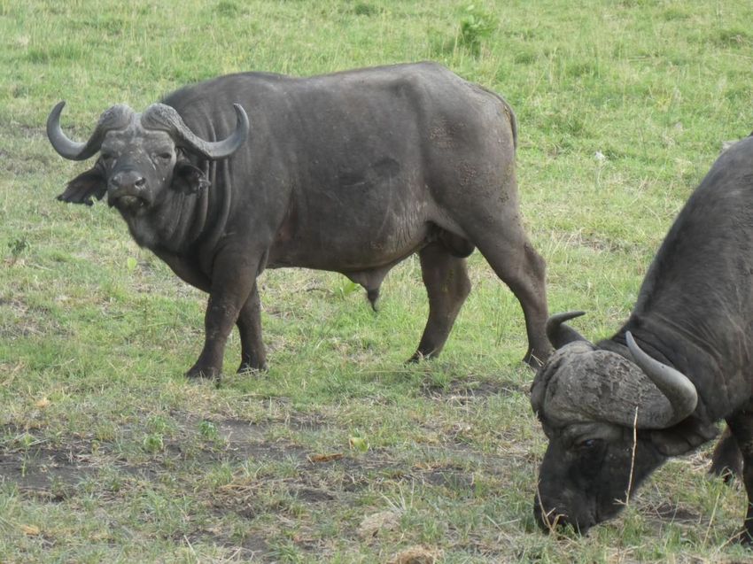
Buffalo in the Luvuvhu riverbed. In this northeastern corner of Kruger the Luvuvhu River runs over the Clarens Formaton
outcrop then out across thick silt deposits that form a broad alluvial plain running east to the Limpopo River. The water
supply and rich riverine forests, which include fever and mustard trees and the sycamore fig, support abundant wildlife.
From the Luvuvhu Bridge drive east through tropical woodland on the S63 dirt road to the Pafuri picnic site to
enjoy your packed lunch (or braai) accompanied by vervet monkeys, views over the river, and an exhibition on
the ecology and history of the area. The trees that line the Luvuvhu riverbank offer an excellent example of a
“gallery forest”. Such forests form corridors through less hospitable terrain and offer animals such as monkeys
and baboons (as well as our hominid ancestors) better protection from predators. In the northeastern side of
Kruger, along the border with Mozambique, have been found innumerable examples of stone tools made by
hominids, starting with Homo erectus (who was also the first to use fire) around 1.5 million years ago, through
to the introduction of more advanced stone tools by Homo sapiens around 250,000 years ago (Middle Stone
Age). By 25,000 years ago, during the Late Stone Age, the origins of modernity in humans produced more
complex toolkits and recognisably hunter-gatherer cultures, these becoming superseded by Iron Age, Bantu-
speaking pastoralists after 2,000 years ago.
Vervet monkey hoping (unsuccessfully) that the
human will break park rules and offer food or
perhaps a beer. According to Wikipedia, vervet
monkeys have been noted for having human-like
characteristics, such as hypertension, anxiety, and
social and dependent alcohol use. It has been only
around 20 million years since our ancestral line split
from that leading to the modern monkeys, a
relatively short time in Earth history. Pafuri picnic
site on the banks of the Luvuvhu River.
19BARCELONA TIME TRAVELLER COMPANION GUIDE Continue east on the S63, looping through lush riverine forest to turn left at a T junction to reach Crooks Corner for extensive views over the Limpopo River. The huge arc of the Limpopo River runs over 1,700km, initially separating South Africa from Botswana and Zimbabwe before flowing into Mozambique here at Crooks Corner, one of Kruger’s biodiversity hotspots. The Limpopo River at Crooks Corner, on the lawless triple boundary between South Africa, Zimbabwe and Mozambique. The view is looking upstream across the river to Zimbabwe. The river varies dramatically in its water content, with huge floods during rainy season cyclonic events (such as that in February 2000) creating havoc and backing up along the Luvuvhu River to deposit silty sediment on the Parfuri floodplain. From Crooks Corner drive south for 2km then west (right) along the paved S63 for 8km to pass roadside exposures of weathered Letaba Formation basalt. Resistant masses of basaltic rocks are gradually eaten away by physical weathering processes such as “onion skin” exfoliation, and chemical breakdown of minerals aided by water soaking through and evaporating within the soils and upper rock layers. Rounded mass of spheroidally decomposing Jurassic basalt on the north side of the S63 shortly before the H1-8 junction. The top surface of this exposure demonstrates classic “onion-skin” physical weathering, also known as “exfoliation”, a phenomenon typical of warm climates. Exposure to hot sun causes the rock surface repeatedly to expand then contract during the cooler night. Over time thin concentric layers of the damaged rock peel off, causing the parent rock mass to shrink in size. The chemical oxidation of the surface layers, favoured by a humid climate, is apparent from the brown colouration which indicates the presence of secondary iron oxides and hydroxides derived from primary iron-bearing minerals in the original basalt. The original grey colour of the fresher parent rock can be seen lower left. 20
BARCELONA TIME TRAVELLER COMPANION GUIDE

Many of the exposures along this roadside display the effects of intense chemical weathering which causes the progressive
destruction of fresh, dark, basaltic rocks. During such tropical weathering the primary igneous minerals (mostly pyroxenes,
olivines and calcium feldspars) in the basalt chemically break down into soft clay minerals and the rock decomposes into soil
and gravel, with calcium carbonate precipitating within and on top of the basalt to form criss-crossing veins and hard
capping layers known as “calcretes”. Such weathering is particularly intense in this northern end of Kruger Park where there
is higher rainfall under a hot climate. The pervasive destruction of fresh rock by chemical weathering explains why there are
very few natural exposures of bedrock across the basaltic mopaneveld savanna of Kruger.

Continue west to the H1-8 and return south to Punda Maria.

21
BARCELONA TIME TRAVELLER COMPANION GUIDE

Day 4: Punda Maria to Shingwedzi

The route back south from Punda Maria to Shingwedzi rest camp is shorter than previous drives and highlights
the splendid Mphongolo River loop on the S56 dirt road which is best taken very slowly in order to enjoy the
scenery and wildlife. An early arrival in Shingwedzi allows time to explore the riverbank environment along the
S50 downstream from the base camp.

Start the day with a brief visit to the Thulamela Hill viewpoint by driving back southeast from the PM Base Camp
but then turn right on to the H13-1. After 2km turn right on to the S98 dirt road that leads northwest for 3km,
climbing into the ridges of Wyllie’s Poort Formation sandstone that characterise this corner of the Park. There is
little rock exposure, but this is one of the few places in northwestern Kruger where you can drive to high ground
with views, in this case over the low basaltic mopaneveld to the east and southeast and beyond to the Lebombo
Hills at the Mozambique border. The western edge of Kruger Park lies less than one kilometre from here,
whereas 10km to the south the outcrop of Soutspanberg Group Precambrian sediments (such as the Wyllie’s
Poort Formation) gives way to that of the underlying ancient basement gneisses.

Return to the H13-1 and turn left. The road initially runs northeast across the Soutpansberg Group outcrop but
then curves southeast to cross ground underlain by much younger rocks: the Karoo Supergroup which, as
Wikipedia will tell you, “is the most widespread stratigraphic unit in Africa south of the Kalahari Desert. The
supergroup consists of a sequence of units, mostly of nonmarine origin, deposited between the Late
Carboniferous and Early Jurassic, a period of about 120 million years”. Unfortunately there is not much evidence
in the flat land surface for this momentous change in geology beneath the lowveld forest.

Elsewhere in Kruger we have several times seen the Clarens Formation sandstones, which are the youngest
sediments of the Karoo Supergroup and in central Kruger rest directly on the ancient gneiss basement. Here in
the northernmost part of the Park, however, the Karoo Supergroup is much thicker and includes sediments lying
below the Clarens Formation. These sediments in places include coal deposits and so are of economic interest
(hence, the “Pafuri Coalfield”), leading to controversy in the 1970’s when a state-owned steel company asked
for permission to make a geological map of the area between Punda Maria and Pafuri in their search for coal
deposits. Protests were raised, emphasising that the National Parks Act of 1976 prohibits prospecting in a
national park, and subsequent coal mining activity was restricted to north of the Luvuvhu River (Tshikondeni
Mine: 25km north of Punda Maria but just 3km from the park border).

After 14km on the H13-1 turn right into the S58 Dzundzwini Loop dirt road (5km) which follows the northern
edge of Dzundzwini Hill at the eastern margin of the Soutpansberg Group outcrop. In 3km stop at the plaque
and sausage tree (left) marking the site of the temporary resting camp set up in 1919 by Captain Johannes
Jacobus (“Kat”) Coetser, the first game ranger to be appointed to control the northern part of the park (Coetser
moved on from here to set up the base camp at Punda Maria, which has a more reliable water supply). To the
south across the road to the right rise exposures of pale sandstones which look like Wyllie’s Poort Formation
rocks but are inaccessible.

22
BARCELONA TIME TRAVELLER COMPANION GUIDE

Exposures of pale sandstones on the north side of Dzundzwini Hill at the eastern edge of the Soutpansberg Group outcrop,
across from the JJ Coetser temporary bush camp.

                                                                        Continue on the S58, passing a turnoff for
                                                                        Dzundzwini Hill (a rough drive best done in a
                                                                        4WD vehicle and not worth it geologically:
                                                                        another partial view over the basalt plain
                                                                        ahead), to reach the H1-7 where you turn
                                                                        right and drive 19km back south across the
                                                                        basaltic lowveld to the S56 junction (right). At
                                                                        this location the Letaba Formation basalts
                                                                        have been mapped as having erupted directly
                                                                        on Soutpansberg Group sediments (the
                                                                        Clarens Formation is absent here). There is no
                                                                        exposure visible from the road, which is a pity
                                                                        because this is the southernmost part of the
                                                                        Soutpansberg outcrop in Kruger.

                                                                        The Babalala Picnic Site, with its thatched shelter
                                                                        built around an impressive sycamore fig, lies a
                                                                        short distance along the S56 west of the H1-7.

23
BARCELONA TIME TRAVELLER COMPANION GUIDE
Elephants are commonly seen around Babalala, in this case providing entertainment for the children.
Elephant heading west from Babalala towards the confluence of the Mdungila and Shisha rivers which together flow into
the Mphongolo River, forming an arterial network in the upper headwaters of the Shingwedzi drainage basin which attracts
wildlife throughout the year.
The 33km loop along the S56 dirt road anticlockwise from Babalala follows the river systems flowing southeast
to join the Shingwedzi River to the north of the Shingwedzi Rest Camp. Allow at least 2.5hrs to drive this loop,
stopping frequently at the many lookouts on the way. The loop offers another example of abundant wildlife in a
beautiful wooded riverine environment, with the additional attraction of occasional exposures of Precambian
basement rocks.
24BARCELONA TIME TRAVELLER COMPANION GUIDE The S56 initially runs southwest from Babalala, leaving behind the flat basaltic plain and moving on to more sandy terrain underlain by Soutenberg Group sandstones and underlying granites and gneisses as it follows the east bank of the Shisha River. Spheroidally weathered remnants of quartz-rich and granitic Precambrian rocks form isolated exposures along the Mphongolo Loop. Around 10km from Babalala the S56 passes the junction (right) to Sirheni Bushveld Camp, where the Mphongolo River flows in from the northwest. Over the next 6km keep visiting successive minor loops for views across this river, passing exposures of granitic basement rocks to reach the prominent outlook shown below: Elephant herd enjoying the Mphongolo River, the banks of which expose east-dipping banded rocks attributed to the Groot Letaba gneisses which are overlain by Jurassic sediments and basaltic lavas as the S56 turns east. Continue driving south then east, staying close to the river to enjoy the best of the riverine forest and wildlife. 25
BARCELONA TIME TRAVELLER COMPANION GUIDE

       Abundant wildlife within the lush riverine forest, sands and basaltic muds alongside the Mphongolo River.

26
BARCELONA TIME TRAVELLER COMPANION GUIDE Around 11km from the Sirheni junction ignore a junction to the left and continue southeast on the S56 which curves east to return to the Letaba Formation basalt outcrop after a further 6km. There are exposures of the basalts on the far riverbank and, by now 9km from the recent junction, one can view a vertical basaltic dyke cutting the deeply weathered and veined Letaba Formation basalts. One for the dyke spotters with zoom lenses: exposure on the southern side of the Mphongolo River seen from the S56. A basaltic dyke cuts vertically through Letaba River Formation weathered basalt. Dykes like these were formed by sheets of magma rising through cracks, commonly feeding younger lava flows in fissure eruptions above. They solidified to form a massive grey rock more resistant to weathering than the surrounding older basalts which are criss-crossed by alteration veins. In a further 3km the S56 reaches the H1-7. Turn right and drive 9km across basaltic mopaneveld, following the lower reaches of the Mphongolo River, to reach the confluence with the Shingwedzi River. Just after crossing the Shingwedzi (one can stop on the bridge) turn left and follow the western riverbank for 2km to the Shingwedzi Rest Camp. If there is time available after check-in, drive out of the eastern gate of the rest camp (not the main entrance) and turn right to follow the S50 for more wildlife viewing along the riverbank. The river initially runs south before turning east beyond the Kanniedood Dam. This area is geologically interesting because for the first time we have entered the outcrop of the Sabie River Basalt Formation (SRBFm) which lies above the Letaba Formation (LFm). All these basaltic lavas slope (dip) gently to the east so that the SRBFm lies above, and is therefore younger than, the LFm. It has been estimated that the SRBFm is up to 5km thick and was erupted over a period of less than half a million years. 27
BARCELONA TIME TRAVELLER COMPANION GUIDE

Hippos in the Shingwedzi River from one of the many riverside lookouts southeast of the Shingwedzi Rest Camp. The
northern bank of the river behind the herd exposes Sabie River Basalt Formation lavas, erupted 181 million years ago, a
very, very long time before hippos evolved from the ancestors of whales, dolphins and porpoises.

                               Barging buffalo on the basaltic banks of the Shingwedzi River.

28
BARCELONA TIME TRAVELLER COMPANION GUIDE
Day 5: Schingwedzi to Olifants RestCcamp
The journey from Shingwedzi to Olifants Rest Camp takes us back south along the H1-6, crossing from the
Shingwedzi River drainage basin to that of the Letaba River. Geologically we follow the boundary between the
mixed woodlands of the western Kruger old cratonic basement and the eastern Kruger Jurassic succession open
savannah grasslands mostly on basalt. Around 50km south of Shingwedzi Rest Camp turn left on to the S144 dirt
road (the “Tropic of Capricorn Loop”), to cross from the sandy, quartzitic soils of the basement gneisses and
overlying Clarens Formation sandstone on to the basaltic soils of the Letaba Formation. The soils in this part of
Kruger support grasslands rather than trees and the open scenery attracts a range of herbivores, often grazing
together in mixed species to aid general alertness against the predators.
Lions resting in the early morning on the drive south along the H1-6 from Shingwedzi.
Just down the road from the lions the tsessebe and wildebeest stay alert on the basaltic soils…
29BARCELONA TIME TRAVELLER COMPANION GUIDE
While the nearby buffalo seems less perturbed as they graze the sweet grasses….
Just after 3km along the S144 make a stop at the N’wambu waterhole (right). Shortly after this turn right on to
the S143, crossing the Tropic of Capricorn at the Tihongonyeni waterhole.
The unremitting barren flatness of the basaltic plain under big skies on the S143 Tropic of Capricorn Loop road.
The S143 runs southeast across the open basaltic plain through ostrich country with views east to the Lebombo
Hills: the main geological objective of today’s drive. At the junction with the S50 (Dipeni Road) turn left and
drive 10km northeast, crossing back over the Tropic of Capricorn, to the track (right) leading to the
Shibavantsengele Lookout, a popular bird-spotting site on the slopes of the Lebombo Hills.
30BARCELONA TIME TRAVELLER COMPANION GUIDE View west from the Shibavantsengele Lookout road back over the basaltic plains that separate the mixed forests of western Kruger from the Lebombo Hills. The red-weathering boulders lying around are of a rock type called “granophyre”, which is rich in quartz and feldspar (and therefore rhyolitic in chemical composition) and much more resistant to weathering than the underlying basalts. The granophyre lies at the top of the Sabie River Basalt Formation and here defines the edge of the Lebombo Hills (sometimes referred to more enthusiastically as “mountains”). The hill of Shibavantsengele (490m) rises to the south of the track and exposes the pale granophyre which forms a prominent outstanding ridge running north-south along the border with Mozambique. Granophyre is a type of finely crystalline granite that has managed to reach high levels in the crust, intruding its way slowly as it cools and solidifies. In this case the granophyre forms a sheet-like mass (called a “sill”: think of a sill as horizontal and a dyke as vertical) that lies towards the top of the basaltic succession. All these rocks (basalts and rhyolitic granophyre) dip gently east, so by driving east we have moved up through successively younger rocks in the Jurassic succession. 31
BARCELONA TIME TRAVELLER COMPANION GUIDE

Drive back south along the Dipeni Road (S50) and at the S143 junction continue south, following the Nshawu
River to rejoin the H1-6 south of Mopane Rest Camp. Here consider a comfort stop at the Mooiplaas Picnic Site.
Although this involves backtracking 8km north along the H1-6 it makes for an attractive break and the
opportunity to stretch your legs.

Now continue south on the H1-6, with at times great views east and southeast to the Lebombo Hills, for over
30km across the basaltic lowveld to the bridge over the Letaba River. From the bridge there are extensive views
downstream east across to the Lebombo Hills, with the added attraction of basaltic dykes well exposed in the
river bank across to the right.

View east downstream from the Letaba River bridge. Exposures of the Sabie River Basalt Formation form low cliffs (right)
and in the distance rise the Lebombo Hills which define the outcrop of younger granophyres and rhyolites that lie above the
basalts.

Leaving the bridge, immediately on the left are exposures of a basalt flow upon a more weathered, older
basaltic unit. Continue south on the H1-6 to visit the Letaba Rest Camp and its excellent elephant museum. One
of the exhibits demonstrates how the ancestors of modern African elephants can be traced back over 40 million
years through Eocene Palaeomastodons, Oligocene Gomphotheres, and Miocene Primelephas. It must have
been quite a journey.

The next stop is Olifants Rest Camp via the H1-5 and H8, and accommodation check-in. The camp is built upon a
ridge of hard rhyolitic rocks in a remote location and offers excellent views over the Lepelle (formerly Olifants)
River gorge.

32
BARCELONA TIME TRAVELLER COMPANION GUIDE

Vertical feeder dykes (centre left and extreme right) cutting the basaltic rocks exposed in the cliff banks upstream from the
Letaba River bridge.

View looking downstream from the Olifants Rest Camp outlook across the Lepelle River. The hard “Olifants Beds” rhyolite on
which the base camp is built continues on the other side of the river forming a prominent topographic feature with a west-
facing steep scarp reflecting the easterly dip of the entire Jurassic succession.

33
BARCELONA TIME TRAVELLER COMPANION GUIDE

The “Olifants Beds” rhyolite is packed full of crystals of pale feldspar set in a fine pink matrix. This rock was erupted around
181 million years ago as magma already full of crystals. Upon eruption the magma suddenly froze to form the fine pink
matrix within which the crystals became embedded, a rock texture known as “porphyritic”.

It is possible to get closer to the rhyolitic Lebombo Hills by driving out from the camp and taking the S93 north
then almost immediately turning right on to the rather rough S44 east for 6km. Where the S44 turns left, take
the track right that leads down to the lookout over the basaltic riverbed and rhyolitic ridge of the Lebombo Hills.

Track leading off the S44 to the lookout with views southeast into the Lepelle River valley 6km east of the base camp. The
western edge of the Lebombo Hills is defined by prominent cliffs of rhyolite which deflect the river towards the southeast.

34
BARCELONA TIME TRAVELLER COMPANION GUIDE

Close up of the Lebombo rhyolite cliff above the Lepelle River on the western edge of the Lebombo Hills. The rhyolitic lava is
cut by horizontal and vertical fractures produced during cooling of this volcanic rock soon after eruption.

                                                                                   Marabou stork on S44 roadside near
                                                                                   Olifants Rest Camp. Possibly the ugliest
                                                                                   bird on the planet, the impressive pink
                                                                                   gular sac is used for just that, to impress
                                                                                   during the mating season.

35
BARCELONA TIME TRAVELLER COMPANION GUIDE
Day 6: Olifants to Skukusa Rest Camp
This excursion visits a diverse range of ecozones, starting with a drive south across basaltic lowveld to Satara
base camp then a splendid diversion up-stratigraphy eastwards almost to the Mozambique border before
continuing south to Tshokane. From here the route moves southeast and down-stratigraphy to progressively
older rocks, crossing from the Jurassic cover rocks back on to the ancient cratonic basement of western Kruger,
with stops at Kruger Tablets and Orpen Rocks before bridging the Sand and Sabie rivers to reach Skukuza, the
largest of the rest camps in Kruger.
From Olifants Rest Camp head back west to the H1-5 and turn south for a short distance to reach the N’wamanzi
Lookout on the right for extensive views over the Lepelle River. Similar views can be enjoyed by stopping on the
H1-5 where it crosses the river 5km further south. When the river bed is exposed one can see here low outcrops
of Sabie River Basalt Formation partially covered by alluvial gravels, sands and mud. The H1-5 continues south,
always still on the outcrop of the same basalt formation, to Satara Rest Camp.
Camouflaged Kudu grazing by the H1-5 roadside and, further down the road, a young male lion. The open savannah lands
on the Jurassic basalt make for excellent wildlife viewing in this part of Kruger.
Black-backed jackal amid
white-backed vultures close
to the H1-5 roadside north
of Satara. The basaltic
savanna soils of the Satara
area encourage the growth
of more abundant
grasslands as compared to
most granitic areas (for
example around Skukusa).
The grass is appreciated by
the herbivorous wildlife
(and, as here, by their
carnivorous predators) but
more prone to higher
intensity wildfires.
36BARCELONA TIME TRAVELLER COMPANION GUIDE
But even the savanna fires have their uses: in this case as a burnt lookout for vultures….
Continue for 5km south of Satara then turn left (east) into the H6 which runs for 20km to the Lebombo Hills.
Initially this spectacular road crosses a particularly desolate stretch of basaltic lowveld. As the Lebombo Range
gets closer the scenery becomes hillier and more vegetated as layers of hard rhyolite at the top of the Sabie
River Formation make their mark on the topography. Pass the S37 (right) then S41 (left) to reach the turnoff
(right) to the N’wanetsi Picnic Site where vehicles can be left at your own risk and there is a paved path (left)
that leads up to a lookout over a natural dam in the Sweni River. As an added bonus here there are excellent
exposures of rocks belonging to the Jozini Formation, these being Jurassic rhyolites that lie above the Sabie
River Formation basalts. For the geologists amongst you, allow me to quote from a 2004 paper by Riley et al.,
“The Jozini Formation crop out in a narrow belt (3–15 km wide) along the border with Mozambique … and
comprise a thick sequence of largely high-temperature, anhydrous ignimbrites, interbedded with rare rhyolite
lava flows. The majority of the rhyolites are porphyritic and contain phenocrysts of one or more of the following:
plagioclase, clinopyroxene, magnetite, quartz and sanidine, plus accessory apatite and zircon.”
(see: http://www.largeigneousprovinces.org/sites/default/files/Riley_et_al_2.pdf).
37BARCELONA TIME TRAVELLER COMPANION GUIDE
Pathway leading up to the
N’wanetsi Lookout, past exposures
of Jozini rhyolite. The apparent
layering shown by the rhyolite
(dipping down from top right to
lower left) is interpreted as due to
flow of the hot rhyolite during
eruption.
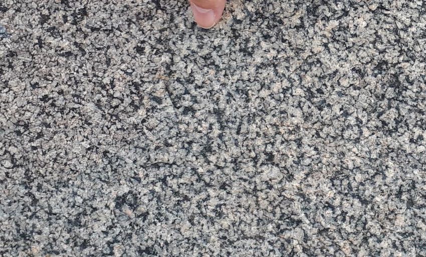
Close up of the flow fabric within
the Jozini rhyolite. The porphyritic
rock is packed full of small pale
feldspar crystals and, just to the
left of the finger, the fabric can be
seen to define a curving fold
interpreted as produced during
viscous flow under gravity of the
hot rhyolite away from the
volcanic vent.
38You can also read