Location Intelligence and Partnerships to support the Sustainable Development Goals - Joinup.eu
←
→
Page content transcription
If your browser does not render page correctly, please read the page content below

ELISE action
Webinar Series

Location Intelligence and
Partnerships
to support the Sustainable
Development Goals
Lorena Hernandez, European Commission JRC
Simon Vrečar, European Commission JRC (external consultant)
Martina Barbero, Deloitte BE                                         European Location Interoperability
Lea Ytrehus, Deloitte BE                                                Solutions for e-Government
Danny Vandenbroucke, KU Leuven
                                                                           Enabling Digital Government through
                                                                             Geospatial and Location Intelligence
30/04/2020
                                                              ISA2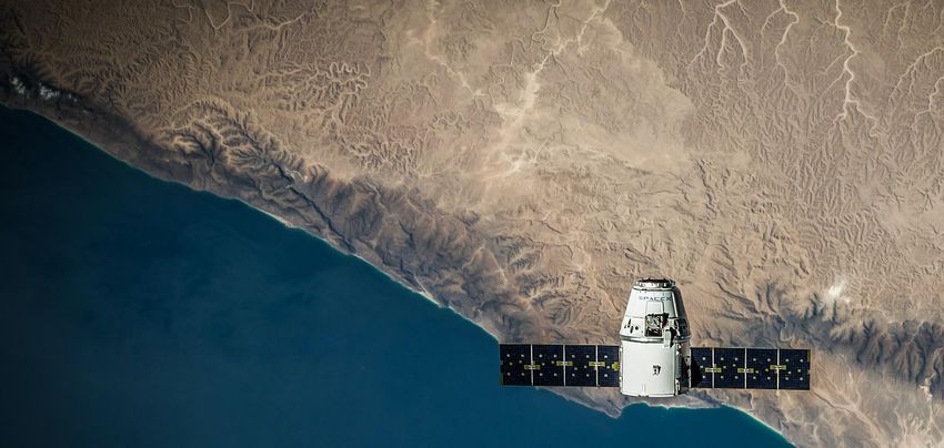
Welcome to the ELISE webinar series

                                                                    ISA2                     ELISE action
                                                                European                    European Location
                                                             Interoperability                Interoperability
                                                               Programme                       Solutions for
                                                                                              e-Government
                                                         Interoperability solutions for   Enabling Digital Government
                                                            public administrations,         through Geospatial and
         Check them out: https://bit.ly/3c5TiSn             businesses and citizens           Location Intelligence

                                                  ISA2
About our speakers

             Martina BARBERO                                       Lea YTREHUS

                          Senior                                            Business
                        Consultant                                          Analyst
                         Deloitte                                           Deloitte

      The views expressed are purely those of the authors and may not in any circumstances be regarded as stating an
                                      official position of the European Commission.

                                                           ISA2
What we will cover today
  1. Context and definitions: what is the link between geospatial and the SDGs?

     2. Partnerships and data ecosystems as enablers for sustainable development

      3. Partnering on solutions: applying location intelligence for development

      4. Challenges ahead: institutionalising partnerships and solidifying ecosystems

     5. Key take-away messages and conclusions

  6. ELISE Contribution: the Energy and Location Applications activity

                                          ISA2
Context and definitions:
what is the link between
geospatial and the SDGs?
Context & definitions: what is the link
                                                                    1.     between geospatial and the SDGs?

“   High-quality, timely geospatial information is often
     overlooked in policymaking, yet is fundamental to
            achieving inclusive growth and sustainable
                                          development.

                Anna Wellenstein, Director, Land and Geospatial, World Bank
                                                                                    ”
Context & definitions: what is the link
                                                    1.     between geospatial and the SDGs?

The Sustainable Development Goals: what are they?
The 2030 Agenda for Sustainable
Development → a shared blueprint
for a more sustainable future

          Sustainable
   17     Development Goals

  169 Specific targets for
      development
    5 Key pillars for delivery
Cooperation and pooling of resources
through global partnerships is one of
the five key pillars.
Context & definitions: what is the link
                                                                   1.     between geospatial and the SDGs?

What ensures an effective delivery of SDG goals?
                                         Lessons learnt from the Millennium
                                         Goals on key tools for delivery:

                                            Collaboration between different types
                                            of actors (Stafford-Smith et al, 2017)

                                            Technology as an enabler for an agile
                                            and integrated global innovation system
                                            (Stafford-Smith et al, 2017)

                                            Availability and reliability of data
                                            (Jaiyesimi R., 2016)

                                                                                Photo by Majharul Islam on Unsplash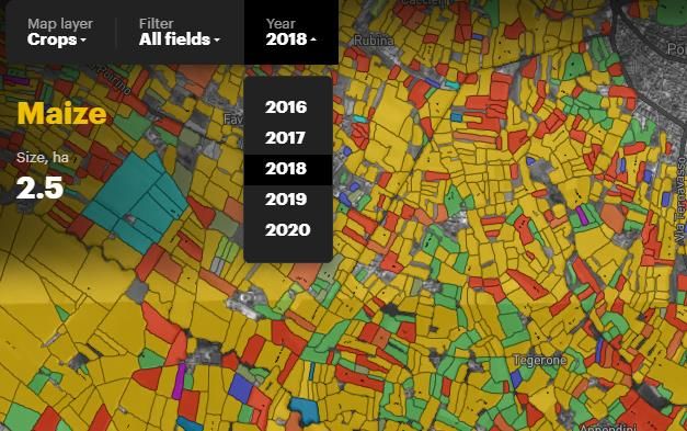
Context & definitions: what is the link
                                                                  1.     between geospatial and the SDGs?

SDGs and their relation to geospatial data: a well established role for
geospatial data

                                                              The role of geospatial
                                                                       for SDGs, and
                                                                     especially how
                                                             geospatial can support
                                                                    monitoring and
                                                             reporting for the SDGs
                                                            (see Eurostat), is a well-
                                                               established theme in
                                                            academic literature and
                                                                            research.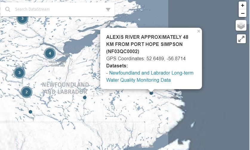
Context & definitions: what is the link
                                                                                           1.     between geospatial and the SDGs?

International efforts for global geospatial management: the work of UN-
GGIM

                                     aims to address global challenges regarding the use of geospatial
                                     information, including in the development agendas, and to serve
                                     as a body for global policymaking in the field of geospatial
                                     information management.

      FUTURE TRENDS IN GEOSPATIAL                            INTER-AGENCY AND EXPERT GROUP ON THE
       INFORMATION MANAGEMENT:                             SUSTAINABLE DEVELOPMENT GOAL INDICATORS
   Smart cities and IoT, AI and big data, integration of                  (IAEG-SDGS)
   data sources, role of private and non-governmental
      actors, cloud computing, open source, open             Working Group on Geospatial Information
               standards, open data Skills…                               (est. 2016).
Context & definitions: what is the link
1. between geospatial and the SDGs?
International efforts for global geospatial management: UN-GGIM Europe
UN-GGIM Europe recent work includes:
A report on the territorial A call for political action in
dimension in SDG indicators: Europe (2019) for the
Geospatial data analysis and integration of statistical and
it integration with statistical geospatial information →
data (2019) →
1. Communication with all
• Harmonisation of data stakeholders
themes
2. Strengthening institutions
• Use of Earth Observation and governance
(EO) data
3. Standards, quality and
• Increased collaboration accessibilityContext & definitions: what is the link
1. between geospatial and the SDGs?
International efforts for global geospatial management: EARSC’s work on
promoting EO data for the SDGs
The European Association of Remote Sensing
Companies (EARSC) promotes the use of Earth
Observation (EO) technology.
Example from SDG 6 clean water & sanitation:
(1) Target 6.1. is to assess water use efficiency
Source: EARSC
(2) Indicator 6.1.1 is the proportion of the
population using safely managed drinking
services
✓ EO can support the mapping and inventory
of wetlands as a basis for management-
oriented assessment and monitoring
Photo by SpaceX on UnsplashContext & definitions: what is the link
1. between geospatial and the SDGs?
SDGs and geospatial data: a well established and long standing relation
The role of geospatial for monitoring and indicators is widely
acknowledged. However, geospatial can also play a role in the
delivery of Sustainable Development Goals.
Two increasingly important dimensions stand out:
The role of new/emerging data ecosystems and partnerships
for the provision of data for development.
The importance of location intelligence in the context of these
data ecosystems in particular.Context & definitions: what is the link
1. between geospatial and the SDGs?
Key definitions for this webinar 1/2
Data Ecosystems are “composed of complex networks of
organizations and individuals that exchange and use data as main
resources. Such ecosystems provide an environment for creating,
managing and sustaining data sharing initiatives.”
(Oliveira and Loscio, 2018.)
Transnational multi-stakeholder partnerships are
“institutionalized transboundary interactions between public and
private actors, which aim at the provision of collective goods.”
(Schäferhoff et al., 2009.)
Photo by Joshua Hoehne on UnsplashContext & definitions: what is the link
1. between geospatial and the SDGs?
Key definitions for this webinar 2/2
Inputs
Location Intelligence refers to “a business intelligence (BI) tool
capability that relates geographic contexts to business data. Like BI, location
intelligence software is designed to turn data into insight for a host of
Processes
business purposes.” (TechTarget)
For this webinar is interpreted as a broader concept encompassing: Outputs
Processes allowing to turn inputs into outputs
Technologies like GIS but Different information sources Insights allowing for to
also Artificial including traditional geospatial make SDGs decisions
Intelligence, digital twins, sources and more innovative more geospatially
augmented reality sources awarePartnerships and ecosystems as enablers for sustainable development
2. Partnerships and ecosystems as enablers for SDG

Partnerships for SDG 17: Building global partnerships and catalyzing
initiatives to strengthen means of implementation
                           • Partnerships for sustainable development are multi-stakeholder
                              initiatives voluntarily undertaken by Governments,
                              intergovernmental organizations, major groups and others
                              stakeholders, which efforts are contributing to the implementation
                              of inter-governmentally agreed development goals and
                              commitments.

                           • Sustainable Development Goal 17, aims to “strengthen the means
                              of implementation and revitalize the Global Partnership for
                              Sustainable Development,” and recognizes multi-stakeholder
                              partnerships key to the achievement of the SDGs.
2. Partnerships and ecosystems as enablers for SDG
“ It is time to bring together official national
statistical data along with geospatial data,
earth observation data and citizen-
generated data and Big Data such that
more real-time data is available to address
the SDGs. This will only help in both
reporting and monitoring purposes and
what it means for data for action and
decision-making.
Aditya Agrawal, Director, Data Ecosystems Development, Global
Partnership for Sustainable Development Data
”2. Partnerships and ecosystems as enablers for SDG
Enriching the SDGs data ecosystem: bringing all together
Geo-aware technologies
Civil society initiatives Citizens generated data
Private companies Official data providers2. Partnerships and ecosystems as enablers for SDG
Monitoring and reporting aided by geospatial in Ireland
• Ireland Sustainable Development Hub is a platform for
reporting on progress towards the SDGs in Ireland.
• Public-Private partnership between Ordnance Survey
Ireland, the Central Statistics Office and Esri Ireland.
Key characteristics and success factors:
A collaborative approach to reporting and sharing
data
Mobilising private and public know-how
A one-stop shop for progress reports and indicator
data for all SDGs
https://irelandsdg.geohive.ie2. Partnerships and ecosystems as enablers for SDG
Humanitarian assistance and monitoring powered
by geospatial: HungerMap LIVE
• A global, near real-time, hunger monitoring
and prediction system developed by the
World Food Program and Alibaba Cloud.
• Combines key metrics from various data
sources, i.e. food security information,
weather, population size, conflict, hazards,
nutrition information and macro-economic
data.
• Data is collected through Computer Assisted
Telephone Interviewing (CATI) and processed
through automatic statistical engines.
https://hungermap.wfp.org2. Partnerships and ecosystems as enablers for SDG
Involving citizens for addressing sustainable development goals
Atlantic Water Network (AWN): Monitoring the quality
of open water sources in Canada
Key characteristics and success factors:
Provision of technology and guidance from AWN
Engaging communities allows a double win: more
data on remote areas and more citizens awareness
of these environmental challenges
Engagement of indigenous communities to
integrate their knowledge in traditional databases
Source: Advancing Sustainability together? Citizen-generated data and the
Sustainable Development Goals
https://atlanticdatastream.ca/Partnering on solutions: applying location intelligence for development
3. Partnering onintelligence
                                                                                                    solutions: applying location
                                                                                                                for development

Location intelligence for development
Location intelligence “is more than analysis of geospatial information or geographic information
systems alone, it is the capability to visualize spatial data to identify and analyze relationships.”
(del Carmen, 2016)

To exploit location intelligence for SGDs (Deloitte 2013), stakeholders need to:

          COLLECT                            CONNECT                            PROTECT
         data available                     with external                        citizens by
        and integrate in                    partners and                       understanding
        decision-making                     data sources                       privacy issues
Proximity networks
Location intelligence for development:
Responses to Covid-19
There are many Covid-19 related initiatives based on
location intelligence and the development of spatial
(thinking) relationships. The following draw insights from
human mobility:
• The Covid-19 Mobility Monitoring project: analyses
anonymized location data to understand the effect of
mobility restrictions and behavioural changes on the
current international COVID-19 outbreak.
• Social Distancing Scoreboard: is an interactive
scoreboard developed by unacast, which is updated daily
to inform and empower organisations to make better
decisions regarding social distancing.
• ShopSafe: aids shoppers in keeping social distance and
tracking availability of products in supermarkets, based
on citizen-generated data and location data provided by
telecom operators.Location Intelligence for development:
AI detected fields and crops
OneSoil uses Copernicus sentinel data
to allow users to explore and compare
fields and crops in Europe and the
United States.
• The map reveals insights about local
and global trends in crop
production, which can be a
significant tool to inform decision-
makers and foster sustainable
policies.
• Sustainable farming and agriculture
is indeed key to achieve the SDGs,
and the work towards zero hunger
for a growing world population.
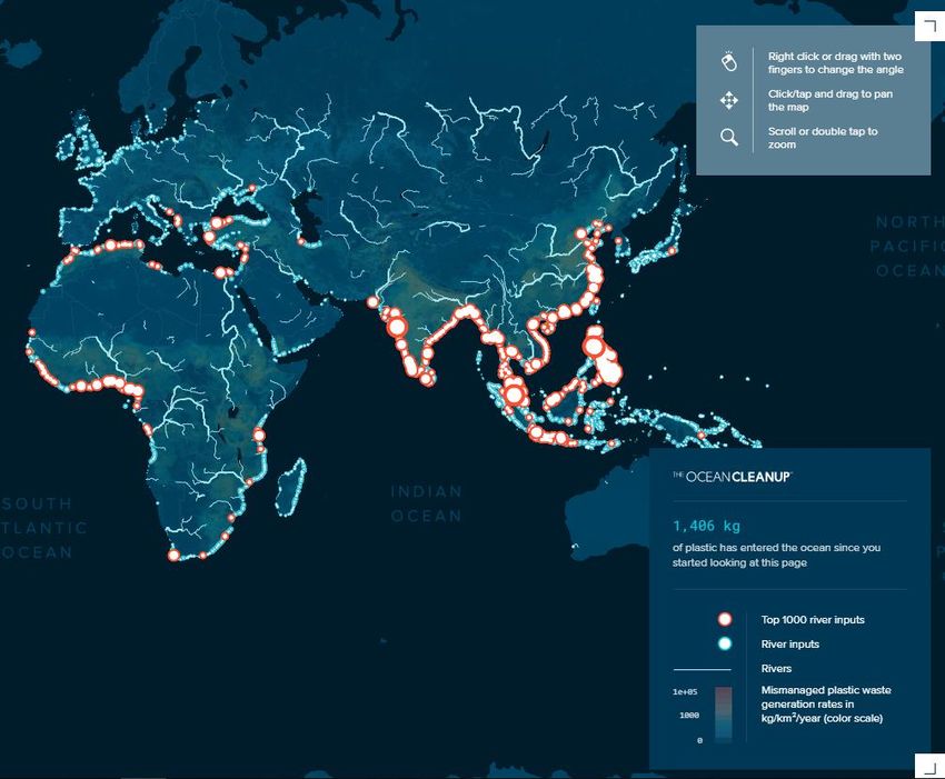
https://map.onesoil.aiNon-profits initiatives powered
by geospatial information
• Ocean Cleanup is an engineering
environmental organization based
in the Netherlands, that develops
technology to extract plastic
pollution from the oceans.
• Use of maps and geospatial
information, developed and
funded by private and public
partners, to predict, visualize
and raise awareness towards
pressing and constantly evolving
issues in the pollution of oceans
and rivers.
https://theoceancleanup.comChallenges ahead: institutionalising partnerships and solidifying ecosystems
4. Challenges ahead

Challenges ahead: what’s next for data ecosystems and location
intelligence in development
Geospatial multi-stakeholder, technology and data centered approaches can help addressing
sustainable development challenges more effectively.

   However it is important to:
   o   Continue to increase the awareness of key stakeholders about the advantages of sharing data (Global
       Partnership for Sustainable Development data, 2019).
   o   Address the question of sustainability and institutionalization of data partnerships and ecosystems put in
       place (MacDonald et al. 2017).
   o   Ensure a degree of flexibility and customization in the data governance and ecosystem approaches (Global
       Partnership for Sustainable Development data, 2019).
   o   Work on capacity building (Lämmerhirt D. et al, 2019).
Take-aways and conclusions
5.Take-away messages

Concluding remarks

 • New trends around geospatial (use
    of EO, Big Data and AI) can
    strengthen its role in SDG beyond
    monitoring and statistical purposes.
 • Data ecosystems and location
    intelligence are relevant. While a lot
    of literature on SDG already focuses
    on data ecosystems, location
    intelligence in practice is still less
    explored.
 • A definition of location intelligence
    should be commonly understood.
ELISE Contribution: the Energy and Location Applications activity
ELISE Energy and Location Applications
• Leverage the use and
exchange of harmonised
location-based data at
building level
• Scale-up
methodologies to assess
energy consumption and
performance from local to
national level
• as required by the
energy efficiency-related
European Directives                       Visit JoinUp to know
                                                 more at:
                                         https://bit.ly/3bFwBE
                                ISA2
                                                    T
References
Committee of Experts on Global Geospatial Information Management, “Geospatial information for sustainable development,” Ninth session,
Bibliography
         1/2   Economic and Social Council, United Nations, New York (2019)

               UN-GGIM, “INTEGRATED GEOSPATIAL INFORMATION FRAMEWORK: A strategic guide to develop and strengthen national geospatial
               information management.” (2019)

               ECOSOC, UN-GGIM. “Resolution on strengthening institutional arrangements on geospatial information management.” Economic and Social
               Council, United Nations (2016)

               Choi, J., Hwang, M., Kim, G. et al. Supporting the measurement of the United Nations’ sustainable development goal 11 through the use of
               national urban information systems and open geospatial technologies: a case study of south Korea. Open geospatial data, softw. stand. 1, 4
               (2016). https://doi.org/10.1186/s40965-016-0005-0
               Stafford-Smith M., Griggs D., Gaffney 0., Ullah F., Reyers B., Kanie N., Stigson B., Shrivastava P., Leach M. & O’Connell D., Integration: the key to
               implementing the Sustainable Development Goals, 2017

               Bano M. Partnerships and the Good-Governance Agenda: Improving Service Delivery Through State–NGO Collaborations, 2019

               Hák T., Janoušková S., Moldan B., Sustainable Development Goals: A need for relevant indicators, 2016

               Jan Kraak M., Rickter B., Engelhartd Y., Challenges of Mapping Sustainable Development Goals Indicators Data, 2018

               Malhotra C., Anand R., Singh S., Applying Big Data Analytics in Governance to Achieve Sustainable Development Goals (SDGs) in India, 2018
Vinuesa R., Azizpour H., Leite I., Balaam M., Dignum V., Domisch S., Felländer A., Langhans S.D., Tegmark M. & Fuso Nerini
Bibliography
2/2 F., The role of artificial intelligence in achieving the Sustainable Development Goals, 2020
Study of Africa Regional Data Cube Governance Frameworks and Operationalization, September 2019
Advancing Sustainability together? Citizen-generated data and the Sustainable Development Goals, 2019
Del Carmen A., What is Location Intelligence, 2016, https://carto.com/blog/what-is-location-intelligence-and-its-benefits/
Giupponi C. & Kumar Gain A., Integrated spatial assessment of the water, energy and food dimensions of the Sustainable
Development Goals, 2017
Jaiyesimi R., The Challenge of Implementing the Sustainable Development Goals in Africa: The Way Forward, 2016
Masó J., Serral I., Domingo-Marimon C., Zabala A., Earth observations for sustainable development goals monitoring
based on essential variables and driver-pressure-state-impact-response indicators, 2019
Global Partnership for Sustainable Development data, A Study of Africa Regional Data Cube Governance Frameworks and
Operationalization, September 2019
Lämmerhirt D., Gray J., Venturini T., Meunier A., Advancing sustainability together? Citizen-generated data and the
Sustainable Development Goals, 2019
MacDonald A., Clarke A., Huang L., Roseland M., Seitanidi M., Multi-stakeholder Partnerships (SDG #17) as a Means of
Achieving Sustainable Communities and Cities (SDG #11), 2017Thank you
Unless otherwise noted the reuse of this presentation is authorised under the CC BY 4.0 license.
All unreferenced pictures come from Pixabay and have no copyright attached.
Icons used for slides 19 and 24 (people’s icons) are copyrighted by Deloitte.
ISA2Stay tuned
Join the ELISE community in JoinUp
@eu_location
eulocation@ec.europa.eu
ELISE playlist
ISA2Q&A
How did we do?
                        Help us to improve our events
                             by filling the survey.

                              Access the survey

                        https://ec.europa.eu/eusurvey/
                            runner/Webinar8-SDG

                 ISA2
                                           Photo by Glenn Carstens-Peters on Unsplash
Next webinar on
Digital Twins
ISA2 Picture of the Helsinki’s Kalatasama ProjectYou can also read