SUBMISSION TO FINGAL COUNTY COUNCIL - Fingal Development Plan 2017 - 2023 Lands at M1 Junction (Junction 4) Lissenhall, Swords - Prepared by Denis ...
←
→
Page content transcription
If your browser does not render page correctly, please read the page content below
SUBMISSION TO FINGAL COUNTY COUNCIL
    Fingal Development Plan 2017 – 2023

    Lands at M1 Junction (Junction 4) Lissenhall, Swords

                 Prepared by Denis Burke
                       On behalf of
                 Landowners in Lissenhall

                       April 2016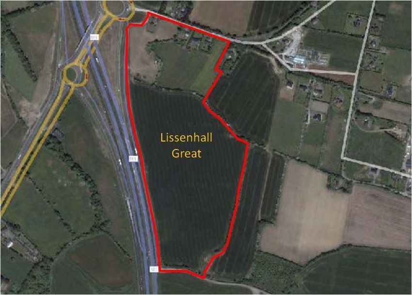
Contents
Executive Summary

1.   Introduction ……………………………………..………………………………………….……………1

2.   Site Description …………………………………...………………………………………………………1

3. Potential Land Uses ……………………………………..…………………………………..……………2

       3.1.   Strategic Location …………………………………………………..………….……………3

              3.1.1.   Dublin-Belfast Economic Corridor …………………………………………..………3

              3.1.2.   Cycle way ……………………………………………………………………….……4

              3.1.3.   Metro North ……………………………………………………………………….…4

              3.1.4.   Metro Dublin Proposal ……………………………………………………….………4

       3.2.   Adjoining Zoning ………………………………………………..………………….………5

       3.3.   Alternative Zoning Options …………………………………………………………..……5

       3.4.   Master Planning …………………………………………………..………………...………6

4. Public Utilities ………………………………………………………………..…………….……………7

       4.1.   Foul Drainage ………………………………………..………………………………………7

       4.2.   Surface Water Drainage ……………………………………….……………………………7

       4.3.   Water Supply …………………………………………..………………………………….…7

       4.4.   Power and Telecommunications ………………………………….…………………...……7

5. Site Observations …………………………………………………..……………………………..………8

       5.1.   Topography …………………………..……………………………………………...………8

       5.2.   Flora and Fauna …………………………….……………………………………….………8

       5.3.   Visual Setting …………………………...……………………………………………………8

       5.4.   Cultural Heritage ………………………………….…………………………………..……8

6.   Conclusions ………………………………...…………………………………………………………….9

Appendix I - Alternative Zoning Objective FP: Food Park (Clustering Opportunity)…….…..…...…......…10

References ………...…………………………………………………………………………………………11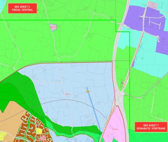
Executive Summary
This submission seeks to promote the subject lands for large scale employment zoning to support economic
development and job creation and prosperity. The purpose of this submission is to provide additional
serviced lands for rezoning consideration by strategic rezoning of additional lands to the north-east of
Swords Town.

The subject lands form part of one of the most strategic infrastructural locations in Fingal and are ideally
located to attract high value employment opportunities to Fingal which has access to a large scale working
population. Its location adjacent to the Lissenhall interchange (junction 4) of the M1 provides direct access to
the M1, Dublin Airport, Port Tunnel, Dublin City, and M50 motorway (that link to the M2, M3, M4, M7 and
M11). Suburban rail from Donabate station provides local services and access to DART and the Dublin-
Belfast inter-city. This strategic location provides direct access to national and international markets by road,
rail, air and sea.

The submission proposes HT: High Technology uses as it is particularly suitable in the context of the
subject lands strategic location on the Dublin – Belfast Economic Corridor, access to a large scale working
population and its close proximity to the proposed metro, national road networks and public utilities and
services. From a design perspective the subject lands provide opportunities for high quality design with a
landmark building(s) and a strong facade onto the M1.

The lands have significant road frontage both along the Hearse Road (R126) and M1 motorway and are
entirely within the 1km line (East) of the proposed Metro North line. They are also within 1km of the
future Metro stop at Lissenhall and within easy reach of Dublin Airport, Port tunnel, M50, Dublin Port.
Development on these lands would be subject to the Section 49 Development Contribution Scheme.

Public utilities are available on site, or on lands immediately adjacent to, i.e. foul water drainage, surface
water drainage, water supply and telecommunications infrastructure, therefore this site can be deemed to be
fully serviced.

The proposed zoning is in keeping with the area as the subject site also directly adjoins the eastern
development boundary of Lissenhall Great (Swords), whose adjoining lands are zoned HT. The subject lands
are ideally located to expand and form a cluster with the adjoining High Technology zoning.
From a development perspective the subject lands could be considered as a ‘ready-to-go’ site, by virtue of
their strategic location, extensive road frontage, overall size, contiguous shape and access to services. In
this context the subject lands would also be ideally suited to other large scale projects in the areas of Food
Park (Figure 5) Education, Healthcare, Biotechnology, ICT, Financial, Environmental, Professional or
Public Services and provide key economic activity and employment opportunities for Fingal.
The subject lands slope gently to the southeast. However the lands are not visually prominent, there are no
contours of any significance on the subject site and they contain no geographical features of note. The lands
are contained within the “Low Lying Agricultural Character Area‟ in the Fingal County Development Plan
2005-2011 and are indicated as being: “a mix of pasture and arable farming land on level land or land with
few views or prospects‟. There is no flora or fauna of particular significance located on the subject lands and
is not located in a zone of archaeological potential. A field survey and initial visual inspection did not reveal
evidence of a significant archaeological site. Therefore its development for Science and Technology
purposes or other suitable economic development and job creation zonings will not have a significant impact
on the landscape or views in the area.
We would welcome an opportunity to discuss this submission further with Fingal County Council.

Denis Burke
Email: OakLodge@IrelandMail.net
1. Introduction
This submission seeks to promote the subject lands in Lissenhall for large scale employment zoning to
support economic development and job creation. Lissenhall has been identified as a strategic development
area1 and this submission proposes additional serviced lands to the north-east of Swords Town for rezoning
consideration.
This proposal would provide employment and economic opportunities for Fingal, particularly to the
expanding town of Swords and Donabate and to the surrounding areas of Portrane, Lusk and Skerries. In
preparing this submission the proximity of the subject lands to the Dublin – Belfast Economic Corridor2,
Metro North and the proposed Dublin Metro expansion from Lissenhall to Malahide3 have been considered.
This submission was prepared by Denis Burke, Swords, Co Dublin on behalf of landowners Burke,
Grimes, Fitzgerald and Shirran, who are the owners of an area of land identified in this submission, to
the north-east of Swords town.
The relevant themes from the Draft Development Plan referenced in this submission are Economic
Development, Movement and Infrastructure, Natural Heritage and Cultural Heritage (Section 5).
The landowners now wish to establish a new use for the lands given the dramatic changes that have taken
place within the Swords area in recent years. This submission has been prepared in order to recommend
that the subject lands Zoning Objective ‘GB’: ‘to protect and provide for a green belt’ be changed to
Zoning Objective ‘HT’: ‘Provide for office, research and development and high technology/high
technology manufacturing type employment in a high quality built and landscaped environment’. This
zoning would be in keeping with lands zoned HT to the south-west of the subject lands.
Based on the strategic and infrastructural location of subject lands, it does not make economic or
planning sense to leave the subject lands as agricultural.
2. Site Description
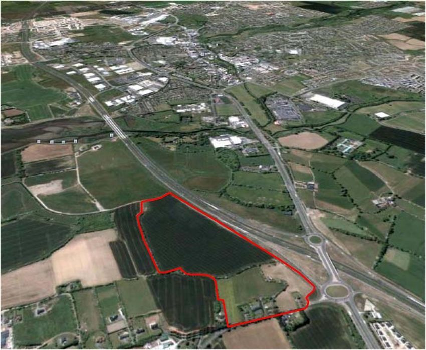
Situated in Lissenhall, the subject lands are broadly rectangular in shape and subdivided by hedgerows
(Figure 1). It is circa 21.5 hectares (53 acres) and located to the north of Swords, adjacent to the M1
Lissenhall interchange (Junction 4), which serves M1, Swords, Donabate, Skerries and Lusk. The
subject lands comprise approximately three fields, currently in agricultural use, and four residential
dwellings. Individual access to dwellings and for agricultural use is currently along Hearse Road (R126)
which runs broadly east west across the northern boundary of the site. The subject lands have significant
frontage both along the M1 motorway and Hearse Road.
1
Paul Reid, Chief Executive, Draft Fingal Development Plan 2017 – 2023 (DFDP) Forward & Glossary.
2
A spatial and economic concept in the National Spatial Strategy 2002-2020 and 2011-2017 Development Plan.
3
Metro Dublin, Proposed Service http://www.metrodublin.ie/index_files/MetroDublinDesign.htm
1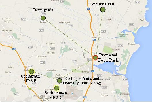
Figure 1 - Subject Lands to the East of Lissenhall Interchange along M1 National Primary Route
3. Potential Land Uses
The purpose of this submission is to provide additional serviced lands for rezoning consideration by
strategic rezoning of additional lands to the north-east of Swords Town. There are a number of
employment generating land use zonings in the Draft Plan that will facilitate business, enterprise and job
creation over the coming Draft Plan period. These zonings, include HT: High Technology, FP: Food
Park, RU: Rural, ME: Metro Economic corridor, GE: General Employment and RW: Retail Warehousing
that allow for enterprise and employment growth opportunities across various economic sectors.4
In relation to Fingal’s economy, the Development Plan is responsible for a number of key
functions which include:
Provide a sufficient quantum of appropriately zoned lands to facilitate enterprise
opportunities and employment creation;
Ensure that such lands are logically and coherently located to maximise on existing
and planned infrastructure, particularly in respect of public transportation, water
services, and telecommunications;
Identify the key business and industry sectors, anticipate their requirements in terms
of building types, formats, and sizes and range of supporting and ancillary services;
Encourage the creation of clusters within sectors thereby maximising associated
economies of scale;
In this regard, the submission to promote the subject lands for large scale employment zoning to
support economic development and job creation is in keeping with the functions above.
4
Draft Fingal Development Plan 2017 – 2023, p21.
2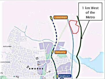
This submission proposes HT: High Technology uses as it is particularly suitable in the context of the
subject lands’ strategic location, access to a large scale working population and its close proximity to
M1 and M50 motorways, Dublin Airport, Rail Station, Dublin Port, Metro North and public utilities
and services. From a design perspective the subject lands provide opportunities for high quality design
with a landmark building and a strong facade onto the M1.
While the submission proposes HT zoning the subject lands could also be suitable for alternative
employment zonings as noted. In this context we would welcome an opportunity to discuss further
with Fingal County Council.
With regard to the potential of the subject lands, these can be explored under the following:
1. Strategic Location
2. Adjoining Zoning
3. Alternative Zoning
4. Master Planning
3.1. Strategic Location
The subject lands form part of one of the most strategic infrastructural locations in Fingal and are
ideally located to attract high value employment opportunities to Fingal, which has access to a large
scale working population.5 Its location adjacent to the Lissenhall interchange (junction 4) of the M1
provides direct access to the M1, Dublin Airport, Port Tunnel, Dublin City, and M50 motorway (that
link to the M2, M3, M4, M7 and M11). Suburban rail rail from Donabate railway provides local
services and access to DART and the Dublin-Belfast inter-city. This strategic location provides direct
access to national and international markets by road, rail, air and sea.
Typical access times from the subject lands are:
M1(200m, 1 min)
Donabate suburban rail (4km 6 min)
Dublin Airport (7km 7 mins)
M50 (8km 6 min)
N2/ M2 (14km 10min)
Dublin Port (via the Port Tunnel – 16km 14min)
N3/ M3 (18km 15 min)
N4/ M4 (23km 18 min)
N7/ M7 (27km 21 min)
N11/M11 (48km, 35 min)
It would not therefore make economic or planning sense to leave the subject lands adjoining this strategic
junction as agricultural.
3.1.1. Dublin-Belfast Economic Corridor
The lands are adjacent to the Dublin-Belfast Economic Corridor (DBEC) which is a spatial and
economic concept included in the National Spatial Strategy 2002-2020 and in the 2011-2017
Development Plan. The strong performance of the Belfast city region in terms of investment
attraction and high quality employment creation provide further employment opportunities for
focused development with regard to these lands.6
5
Indecon (May 2008) Economic Development Strategy for Metro North Economic Corridor (MNEC), p. iv.
6
Same, p30, p186.
33.1.2. Cycle way
Objective 16 (DONABATE) is to provide a pedestrian path and cycle lane on the Hearse Road to
enable safe access to Donabate Village.7 The planned upgrading of Hearse Road to distributor road
standard8 would provide opportunities to build a cycle way adjacent to the subject lands, which
would facilite a continuous cycleway between Donabate village and Swords utilizing the existing
cycle underpass at Junction 4.
Figure 2 – Lands (in red) within Metro North 1km Corridor
3.1.3. Metro North East
As part of the Lissenhall LAP, Objective 24
(SWORDS) seeks to facilitate and actively promote the
provision of a Lissenhall Metro North Stop that would
include significant Park and Ride capabilities and bus
service facilities.9 In this context promoting the subject
lands for large scale employment would help address
An Bord Pleanála observations (with regard to the
Lissenhall Metro stop) that there was an ‘absence of a
statutory framework for future development north of
Swords’.10
As the subject lands are entirely within the 1km line (East) of the proposed Metro line and Metro
stop at Lissenhall (Figure 2) any development on these lands would be subject to Section 49
Development Contribution Scheme.
Figure 3 – Dublin Metro: Proposed Lissenhall to Malahide route.
3.1.4. Metro Dublin Proposal
A private consortium Metro Dublin
proposes to create and deliver a cost Subject Donabate
effective transit metro network for Lands Lissenhall
11
Dublin. One of their proposed routes
is the LS2 Northern railway westward
to the M1 at Lissenhall (new Metro Seatown
stop East of M1). This proposed route
sees the Metro extending from
Lissenhall to Malahide with the Swords
proposed new Lissenhall Metro stop
Malahide
adjacent to the subject lands (Figure 3). Airside
While Metro Dublin does not currently
have the support of the NTA it is in talks with An Bord Pleanála. After presenting their Dublin
Metro proposal to Dublin City Council, the Council adopted the following Order in February 2016:
‘Motion agreed that the City Council explores the potential for cooperation between Metro Dublin
and Dublin City Council to secure the potential benefits of Metro Dublin for the city, and that the
Council Engineers would meet with Metro Dublin to further this’.12
7
Draft Fingal Development Plan 2017 – 2023, p109.
8
Same, Appendix 6 - p123.
9
Same, p93.
10
An Bord Pleanála Railway Order, Transport (Railway Infrastructure) Act 2001 - 2010 Railway (Metro North –
Belinstown to St. Stephen’s Green) order 2010, p5.
11
Metro Service http://www.metrodublin.ie/index_files/MetroDublinDesign.htm
12 rd
Strategic Policy Committee Planning and International Relations and Property Development Meeting – 23
February 2016, pages 2 and 3.
4Figure 4 – Adjoining Land Zoning (Subject Land outlined in red)
3.2. Adjoining Zoning
Adjacent to the subject lands, there is a range of
residential and employment related zonings and
developments (Figure 4). These include lands
zoned High Technology (adjacent, to the West),
Metro Economic), General Employment (North),
Rural (North) and general industrial uses (further
South) and residential (East and West).
The subject lands are ideally located to cluster
with the adjoining High Technology zoning and
would provide additional technology
infrastructure for Swords in a timely and coherent
manner.
From the perspective of Metro North it is essential to provide more employment zoned lands if Swords
is to reach its critical mass to sustain the significant public transport infrastructure. Due to its
strategically located position the subject lands are ideally located to provide additional employment
zoned lands.
3.3. Alternative Zoning Options
As noted previously the subject lands could be considered for other employment zonings. Indecon
identified key employment and economic activities for strategic sites in Swords and Lissenhall that are
within the MNEC13 and noted the importance of attracting knowledge based industries. An indicative
breakdown of potential economic activities for Swords and Lissenhall include:
Higher Education – Lissenhall (with research and possibly new business/management
school)
Hospital and Health – new private hospital and ancillary services
Biotechnology park at Lissenhall – Science Foundation Ireland (SFI) sponsored with DCU
ICT Park at Lissenhall and/or Swords Business Park – SFI sponsored with DCU
Financial and insurance services – Lissenhall, Lissenhall Great, Swords Business Park
Environmental Services
Professional services (business, legal etc.) – Lissenhall, Swords Business Park
Public sector services – Lissenhall Great
Leisure and recreational – Lissenhall
Tourism – Lissenhall and town centre sites (e.g. Swords castle)
International and other high value-added services
One focus of the Draft Development Plan is to maximise existing performing sectors by fostering
growth opportunities and identifying areas for job creation. Along with High Technology the Agri-
Food sectors have been identified as providing Fingal’s local economy with many opportunities for
further development and expansion14 by virtue of the location of Dublin Airport and the County’s
horticultural and agri-business sectors. Fingal’s objective (ED04) seeks to support and
13
Indecon (May 2008) Economic Development Strategy for Metro North Economic Corridor (MNEC), p18.
14
Draft Fingal Development Plan 2017 – 2023, p181 – 182.
5promote new and emerging clustering opportunities across all economic sectors within the
County.15 Due to the proven advantages of economic clusters, this approach to enterprise
and employment location will be expanded as part of the National Clustering Initiative.16
In this context Food Wise 2025 launched an ambitious ten year plan for the agri-food
sector,17 which includes an objective to increase agri-food exports by 85 per cent.18
3.4. Master Planning
In terms of master planning there are opportunities to distinguish the subject lands strategic location in
Swords. The subject lands provide opportunities for high quality design and build to create landmark
buildings with strong facades onto the M1. 19
While this submission proposes the strategic rezoning of the subject lands for HT: High Technology
other employment zonings (as previously noted) could also be considered. An alternative zoning (by
virtue of the lands strategic location) would be to faciliate the clustering of existing and proposed
Food Parks in Fingal (Appendix 1 – Figure 5).
We would welcome an opportunity to discuss this further with Fingal County Council.
15
Draft Fingal Development Plan 2017 – 2023, p187.
16
Action Plan for Jobs 2016, January 2016, Department of Jobs, Enterprise and Innovation, p 10.
17
Same, p 88.
18
Same, p 83.
19
Fingal County Councils (2008) Your Swords – An Emerging City Strategic Vision 203, p85.
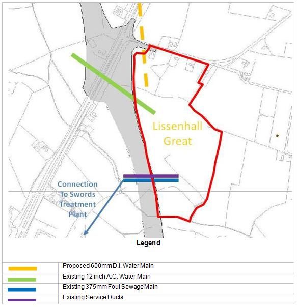
64. Public Utilities
Public utilities are available on the subject lands, or on lands immediately adjacent to it (Table 1),
i.e. foul water drainage, surface water drainage, water supply and telecommunications infrastructure
(Figure 5)
Table 1- Available Public Utilities Services Figure 5 – Infrastructural Services Map
Foul Sewage Drainage
Surface Water Drainage
Water Supply
Power and Telecommunications
4.1. Foul Drainage
The subject lands are served by mains
drainage, which runs across the M1
National Primary Route (this was erected
as part of an agreement with Mr. Grimes
and the contractors for the M1 Lissenhall
extension) to facilitate future
developments on the subject lands. The
Swords Wastewater Treatment Plant is
located less than 0.5kms with access
across the M1 motorway via a field
which Mr. Grimes owns. There are 2 no.
four inch ducts running alongside the M1
Motorway. Therefore, the subject lands
can be deemed to be fully serviced
(Figure 3).
4.2. Surface Water Drainage
At present the surface water from the lands drain via a stream to the south to a network of surface
water courses along established field boundaries which ultimately drain to the Broadmeadow
Estuary. There are several ditches in the area that have sufficient surface water capacity and as a
result the lands are not subject to seasonal flooding. It will be necessary to provide surface water
attenuation for any accelerated runoff from any new development on the site in order to ensure that
such development will not contribute to downstream flooding. This can be achieved subject to the
implementation of suitable attenuation measures.
4.3. Water Supply
The subject lands are served by an existing water main running from west to east. Also, there is
permission for a 4 inch tapping to that main in the event of gaining planning permission on the
subject lands. Accordingly water supply facilities are available to service the subject lands.
4.4. Power and Telecommunications
Fingal is well served in this regard with broadband infrastructure readily available, including 15-80
Gbit/s Dense Wavelength Division Multiplex (DWDM) and an Integrated Service Digital Network
(ISDN) platform which allows for Digital Subscriber lines or DSL service from ISP (internet
Service Providers). These facilities are available to the subject lands and will facilitate their
development for employment purposes, especially employment related to High Technology.
75. Site Observations
Based on previous work by Ryan Walsh & Associates the following observations have been made.
1. Topography
2. Flora and Fauna
3. Visual Setting
4. Cultural Heritage
5.1. Topography
The subject lands slope gently to the southeast. However the lands are not visually prominent,
there are no contours of any significance on the subject site and they contain no geographical
features of note.
5.2. Flora and Fauna
The subject lands are bounded by typical native hedgerows and are currently under crop. There is
no flora or fauna of particular significance located on the site. In relation to any fauna that may be
present on the site there are sufficient habitats on adjoining lands to the south and west to sustain
existing populations. There are no significant areas of heath land, rock outcrop, woodland or lichen
colonies within the subject lands.
5.3. Visual Setting
The subject lands are contained within the “Low Lying Agricultural Character Area‟ in the Fingal
County Development Plan 2005-2011 and are indicated as being: “a mix of pasture and arable
farming land on level land or land with few views or prospects‟. The lands are not overtly visually
prominent, given the impact of the development of motorway, their topography and the presence
of boundary planting. Therefore its development for High Technology purposes will not have a
significant impact on the landscape or views in the area.
5.4. Cultural Heritage
The site is not located in a zone of archaeological potential and a field survey and initial visual
inspection did not reveal evidence of a significant archaeological site.
86. Conclusions
From a development perspective the subject lands could be considered as a “ready-to-go” site, by
virtue of their strategic location, extensive road frontage, overall size, contiguous shape and access
to services.
The subject lands form part of one of the most strategic infrastructural locations in Fingal and are
ideally located to attract high value employment opportunities to Fingal, which has access to a
large scale working population. Its location adjacent to the Lissenhall interchange (junction 4) of
the M1 provides direct access to the M1, Dublin Airport, Port Tunnel, Dublin City, and M50
motorway (that link to the M2, M3, M4, M7 and M11). Suburban rail rail from Donabate railway
provides local services and access to DART and the Dublin-Belfast inter-city. This strategic
location provides direct access to national and international markets by road, rail, air and sea.
The subject lands would be ideally suited to large scale projects as proposed for High Technology or
alternatively for a Food Park (Appendix 1 – Figure 6), Education, Healthcare, Biotechnology, ICT,
Financial, Environmental, Professional or Public Services and provide key economic activity and
employment opportunities for Fingal.
Based on the subject lands’ strategic and infrastructural location it would not make economic or
planning sense to leave the subject lands as agricultural.
9Appendix I
Alternative Zoning Objective FP: Food Park
(Clustering Opportunity)
Obectives RF76 and RF8 Support and facilitate the growth of the agri-food sector in Fingal by
directing and encouraging agribusiness that rely primarily on imported food and produce into areas
which have adequate road infrastructure and which are appropriately zoned.20
The lands are strategically located to play a key role with regard the clustering for High Technology,
Pharmaceutical or a Food Park. Its location would for example facilate the ‘anchoring’ of existing
and proposed Food Parks in Fingal by providing commercial and financial location synergies and
benefits with regard to Agri manufacturing, processing, transport logistics, supply chain
consolidation, shared central services, joint purchasing, intertrading and joint ventures, innovation,
research and development, sustainability, marketing, exhibition centre, and administration. The lands
are within easy reach of existing and planned Food Parks and suppliers (Figure 6).
Country Crest Lusk (11min 9.8km)
Roslin Food Park (12min, 8km)
Sam Dennigan Food Company (18min 14km)
Coolrath (MP 3.B – 18mim 20.8 km)
Figure 6 –Food Map Clustering Map
20
Draft Fingal Development Plan 2017-2023, p168-169.
10References
Action Plan for Jobs (2016), Department of Jobs, Enterprise and Innovation.
An Bord Pleanála Railway Order (2010), Transport (Railway Infrastructure) Act 2001 - 2010 Railway
(Metro North – Belinstown to St. Stephen’s Green) order 2010.
Dublin County Council (2016) Strategic Policy Committee Planning and International Relations and
Property Development Meeting – 23rd February 2016
Fingal County Council (2015) Draft Fingal Development Plan 2017-2023
Fingal County Council (2008) Your Swords – An Emerging City Strategic Vision 2035
Fingal County Council (May 2009) The Future Is In Your Hands
Indecon (May 2008) Economic Development Strategy for Metro North Economic Corridor (MNEC)
Metro Dublin http://www.metrodublin.ie/index_files/MetroDublinDesign.htm
11You can also read