M6 JUNCTION 23 HAYDOCK ISLAND - Capacity Feasibility Study ST. HELENS COUNCIL
←
→
Page content transcription
If your browser does not render page correctly, please read the page content below
ST. HELENS COUNCIL

M6 JUNCTION 23 HAYDOCK
ISLAND
Capacity Feasibility Study
Revision A

JUNE 2019                    CONFIDENTIAL

ST. HELENS COUNCIL

M6 JUNCTION 23 HAYDOCK ISLAND
CAPACITY FEASIBILITY STUDY
Revision A

TYPE OF DOCUMENT (VERSION) CONFIDENTIAL

PROJECT NO. 70044810

DATE: JUNE 2019

WSP
1st Floor, Exchange Station,
Tithebarn Street,
Liverpool
L2 2QP
Phone: +44 151 331 8100

WSP.com


QUALITY CONTROL

Issue/revision     Original            Revision A

Remarks            First Issue         Second Issue

Date               29th January 2019   14th June 2019

Prepared by        Rory Lingham        Martin Boardman

Signature          RL                  MB

Date               11/2/19             14/6/19

Checked by         Nick Green          Nick Green

Signature          NG                  NG

Date               12/2/19             14/6/19

Authorised by      Tony Gordon         Tony Gordon

Signature          TG                  TG

Date               13/02/19            14/6/19

Project number     70044810            70044810

M6 JUNCTION 23 HAYDOCK ISLAND                                   WSP
Project No.: 70044810                                      June 2019
ST. HELENS COUNCIL                                       Page 1 of 42

CONTENTS

1.      THE COMMISSION                                                       1

2.      BACKGROUND AND CONTEXT                                               4

3.      EXISTING JUNCTION                                                    7

4.      DESIGN WORKSHOP – OPTIONS AND DISCUSSION                           12

5.      SCORING MATRIX                                                     17

6.      MODEL DEVELOPMENT                                                  20

7.      OPTION A – DIVERSION OF A49 LODGE LANE IN ISOLATION                23

8.      OPTION B – RELOCATION OF STRAIGHT-AHEAD LANES AND
        REALIGNMENT OF RIGHT-TURN LANES                                    26

9.      OPTION C – COMBINED A49 LODGE LANE DIVERSION WITH
        RELOCATION OF STRAIGHT-AHEAD LANES AND REALIGNMENT OF
        RIGHT-TURN LANES                                     29

10.     OPTION D – DIVERGING DIAMOND INTERCHANGE                           32

11.     OPPORTUNITIES FOR ENCOURAGING ALTERNATIVE TRAVEL
        MODES                                                              35

12.     CONCLUSIONS AND NEXT STEPS                                         38

      WSP                                    M6 JUNCTION 23 HAYDOCK ISLAND
      June 2019                                           Project No.: 70044810
      Page 2 of 42                                      ST. HELENS COUNCIL
APPENDICES

DEVELOPMENT PROPOSALS AFFECTING M6 J23

FIVE-YEAR ACCIDENT STATISTICS 2013-2017

TRAFFIC SURVEY

SITE VISIT NOTES

INTERIM WORKSHOP REPORT

STRATEGIC MODELLING REPORT

LOCAL JUNCTION MODELLING REPORT

DRAWINGS OF PREFERRED OPTIONS

COST ESTIMATES

ASSESSMENT OF OPPORTUNITIES FOR ENCOURAGING ALTERNATIVE TRAVEL
MODES

M6 JUNCTION 23 HAYDOCK ISLAND                                   WSP
Project No.: 70044810                                      June 2019
ST. HELENS COUNCIL                                       Page 3 of 42

1
THE COMMISSION

1. THE COMMISSION
Through the Lot 1: PSC1 Civil Engineering Consultancy Services 2017-2021 Framework, WSP has
been commissioned by St Helens Council, in partnership with Highways England and Wigan Council
(known as the J23 Steering Group in this report), to undertake a junction improvement study of The
M6 Junction 23 (Haydock Island) (M6 J23). The study will advise the preparation of the St. Helens
Local Plan 2018-2033 (including the Infrastructure Delivery Plan) and may ultimately lead to the
development of a future major transport scheme with the partner organisations.
This study forms part two of the five-stage M6 J23 Improvement Programme (as identified in the
Project Brief) and examines the existing issues at the junction and produces preliminary design
options for improvements. The scheme types were identified in a workshop attended by the partner
organisations in 2017 and these have been identified in the Brief:
Scheme Type 1: Improvements that could be carried out on Junction 23 itself to provide
additional capacity such as additional lanes;
Scheme Type 2: Improvements or relatively minor new infrastructure on the Liverpool City
Region Key Route Network and Local Road Network in St Helens and Wigan within
approximately 2 miles of the junction, that may remove existing local traffic from the junction;
Scheme Type 3: Major new infrastructure on the roads at and approaching the junction to
provide free-flow slip roads and/or grade separated flows.
This study uses the traffic demand forecasts from the St Helens SATURN Model, as well as the
modelling support provided by Highways England through their LINSIG model of M6 J23. This study
will ultimately provide the evidence case for the J23 Steering Group to obtain funding for the detailed
design stage of the project.
The following project methodology was developed based on the information provided in the brief and
subsequent discussions with the J23 Steering Group:
Evaluate existing documents, consider forecast traffic demands, undertake a traffic survey and
visit the site to identify the current issues at the junction;
From this information, multiple conceptual options would be developed for improving capacity
and reducing congestion at the junction. The options would deliberately vary in scale,
programme and ambition in line with the three core scheme types identified in the brief;
In accordance with the requirements of the brief, “a review of opportunities for alternative
improvements around active travel or public transport to address transport demand at this
location” would be undertaken;
A design workshop would be hosted by WSP to present the conceptual options to the relevant
stakeholders and to rank them based on several criteria including traffic and safety benefits,
outline costs and buildability;
The outcome of the workshop would be presented to all stakeholders in the format of an interim
report;
Progress meetings would be held with the client organisations to confirm which options would be
further developed;
M6 JUNCTION 23 HAYDOCK ISLAND WSP
Project No.: 70044810 June 2019
ST. HELENS COUNCIL Page 1 of 42
The short-listed design options would be modelled and a design options appraisal would be
undertaken. This would include a consideration of cost, programme and an assessment of the
benefits and drawbacks of each option;
A final report would be prepared, providing details of the final options and an identified
programme for the next stages to provide the evidence case for Stage 3 of the project to be
funded.
This commission also includes a ‘review of opportunities for alternative improvements around active
travel or public transport to address transport demand at this location’ as outlined in Task 4 of the
brief.
WSP M6 JUNCTION 23 HAYDOCK ISLAND
June 2019 Project No.: 70044810
Page 2 of 42 ST. HELENS COUNCIL2
BACKGROUND AND CONTEXT
CONFIDENTIAL2. BACKGROUND AND CONTEXT
2.1. The Junction in its Regional Context
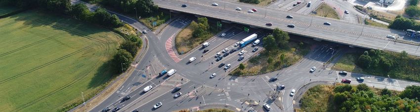
The M6 Junction 23, is a strategically important, all movement junction connecting the A580 (East
Lancashire Road) and A49 (Lodge Lane) with the M6. Both the A580 and A49 were formerly Trunk
Roads with responsibility for their management and maintenance resting with the Highways Agency.
Within the St Helens area, this responsibility now has transferred to the local Highway Authority, St
Helens Council.
The A580 acts as a Primary Distributor linking Manchester with Liverpool and connects several
other major towns in the region including Salford, Leigh, St Helens and Knowsley. The road also
acts as a District Distributor, providing access from many industrial and distribution sites to the
Strategic Route Network (SRN), the M6. Additionally, the A580 provides the link between the local
highway network in St Helens and the M6.
The A49 is no longer on the Primary Route Network but nonetheless is included on the Key Route
Network (as is the A580) within the Liverpool City Region Combined Authority.
2.2. Programme of Previous Highways Improvements at the Junction
The A580 was the UK’s first specifically designed inter urban road and opened in 1934. It comprised
of a 30 feet wide single carriageway, marked out as 3 lanes. It was widened to dual carriageway
standard in the 1960s and the “cut through” beneath the M6 was constructed in the 1970s.
Minor improvements at the M6/A580 junction were subsequently carried out including widening of
the “off” slip roads from the motorway and provision of measures for cycling and pedestrians.
Although the A580 was de-trunked in 2004, the Highways Agency elected to retain responsibility for
the gyratory section, for 200m of the approaches to the junction on the A580 and for the traffic
signals at the junction.
Despite these improvements, congestion at the junction continued to increase. Due to continued
requests for improvement from local businesses, St Helens Council and Haydock Park Racecourse,
a scheme was promoted by the Highways Agency for inclusion in their national “Pinch Point”
Programme. This “Pinch-Point” scheme was constructed during 2014/15 and comprised:
a) Widening of the A580 “cut-through” beneath the motorway to provide two straight-ahead
and two right-turning lanes in both directions.
b) Widening of the “off” slip roads from the M6 to give increased capacity
c) Minor widening of the carriageway within the junction to improve capacity and traffic
circulation.
Although the “Pinch Point” Scheme gave some improvement to the operational performance and
reduced congestion at the junction, the M6 J23 still experiences significant congestion during peak
traffic times and when race meetings are held at Haydock Park. It is considered essential that the
junction’s capacity is improved to manage the existing traffic flows and to facilitate the projected
development growth anticipated in the area.
WSP M6 JUNCTION 23 HAYDOCK ISLAND
June 2019 Project No.: 70044810
Page 4 of 42 ST. HELENS COUNCIL2.3. Development Proposals Affecting the Junction
The St Helens Draft Local Plan Preferred Options was published in December 2016. This was
subject to consultation and amendment and the St Helens Local Plan Submission Draft version was
approved by Cabinet on 12th December 2018 and full Council on 19th December 2018. Within the
Plan, potential development sites are identified together with their impact on the highway network.
Several of the development sites would generate considerable traffic flows which would affect M6
J23 and these sites are included in Appendix A.
M6 JUNCTION 23 HAYDOCK ISLAND WSP
Project No.: 70044810 June 2019
ST. HELENS COUNCIL Page 5 of 423 EXISTING JUNCTION
3.     EXISTING JUNCTION

3.1.   Personal Injury Accident Data
       The accident data includes J23 and the approach roads up to 60m from the junction. The 5-year
       data has been split into two groups - accidents before the “Pinch-Point” scheme improvements
       (2013-14) and accidents after (2015-17). Splitting the data into these two groups helps to identify
       whether the “Pinch-Point” scheme has reduced accidents. A sketch summarising this data is
       provided in Appendix B.

       Table 3-1 – Five-Year Accident Data (2013-2017)

                    Accident Type                    Before Pinch Point    After Pinch Point       Overall
                                                     Scheme (2013-14)      Scheme (2015-17)       (2013-17)

               Failed to stop at red light                  19                     13                32

                       Shunting                              5                     5                 10

                      Side swipe                             1                     3                  4

                Mid-junction collisions                      1                     3                  4

                    Loss of control                          2                                        2

          Rolling back while stopped at lights                                     1                  1

           Vehicle short cut through garage                  1                                        1

                         Total                              29                     25                54

                   Average per year                         14.5                  8.33              10.8

       Table 3-2 – Accident Data Vehicle Types

                             Types of Vehicles Involved in         Number of Vehicles
                                      Accidents
                                             Cars                           97
                                   Van/Goods Vehicles                       16
                                        Motorbikes                           2
                                       Pedal Bikes                           1
                                   Other/Not Specified                       1
       Out of the 54 accidents in the five-year period, 8 resulted in serious injury and 46 resulted in slight
       injury. There were two main clusters of accidents, at the eastbound and westbound approaches and
       exits on A580.
       Of the 25 accidents since the pinch point scheme (2015-17), 3 resulted in serious injury and 22
       resulted in slight injury. The main concentrations of accidents are located on the east side of the

       M6 JUNCTION 23 HAYDOCK ISLAND                                                                     WSP
       Project No.: 70044810                                                                        June 2019
       ST. HELENS COUNCIL                                                                         Page 7 of 42
junction with traffic travelling eastbound. Following the improvement works, accidents that result
from a “failure to stop at red light” have reduced on both the eastbound and westbound approaches
to J23. It should be noted that “failure to stop at red light” was by far the most frequent cause of an
accident, accounting for 65% and 52% of all accidents, before and after the implementation of the
“Pinch-Point” scheme, respectively. The figures indicate that traffic signal cameras may be justified
for installation at the junction to ensure better compliance with signals.
There was one fatal accident in the area (not included in these results) approximately 400 metres
east of the junction turning right on to East Lancashire Road from the farm track cutting across the
westbound lane of the East Lancashire Road.
During 2013 and 2014 there were 29 personal injury accidents (14.5 per year) compared to 25
Personal Injury Accidents (8.33 per year) between 2015-17. This indicates that the accident rate has
decreased by approximately 40% since the completion of the “Pinch Point” scheme. However, the
accident rate is still very high and the junction has the worst accident rate in St Helens and one of
the worst in Merseyside. The junction would justify inclusion as an Accident Investigation and
Prevention scheme.
3.2. Traffic Survey
Traffic surveys were undertaken at M6 J23 in 2018 to provide data for local junction models and to
enable a better understanding of the performance of the junction under typical conditions.
The traffic surveys conducted included:
Turning count surveys
Queue length surveys
Journey time surveys
Drone surveys
The surveys recorded at the junction were conducted in Summer and Autumn in July, September
and November 2018 respectively. 12-hour traffic flows recorded during the Summer survey are
shown in Tables 3-1. Peak hour turning movements are provided in Table 3-2.
Table 3-1 – 12-Hour Traffic Volumes at M6 Junction 23 (Vehicles)
Arm Name Total Inbound Total Outbound
A M6 Junction 23 (N) 5,406 6,840
B A49 Lodge Lane (N) 4,989 2,843
C A580 East Lancashire Road (E) 9,617 8,490
D M6 Junction 23 (S) 5,391 8,311
E A49 Lodge Lane (S) 3,932 3,582
F A580 East Lancashire Road (W) 8,064 7,471
G Shell Petrol Station 839 701
Total 38,238 38,238
WSP M6 JUNCTION 23 HAYDOCK ISLAND
June 2019 Project No.: 70044810
Page 8 of 42 ST. HELENS COUNCILTable 3-2 – Observed Peak Hour Turning Volumes
AM Peak Hour (08:00-09:00) Survey Flows (vehicles)
M6 North A49 North A580 East M6 South A49 South A580 West Petrol
Station
M6 North 5 202 790 5 178 22 3
A49 North 11 1 194 249 57 11 1
A580 East 425 136 2 205 78 581 18
M6 South 4 211 154 1 116 445 11
A49 South 180 56 47 43 0 141 11
A580 West 49 118 577 424 103 1 0
Petrol Station 41 23 30 51 14 2 0
PM Peak Hour (17:00-18:00) Survey Flows (vehicles)
M6 North A49 North A580 East M6 South A49 South A580 West Petrol
Station
M6 North 1 117 859 5 284 112 2
A49 North 37 0 228 295 63 29 1
A580 East 503 104 5 166 64 654 14
M6 South 6 383 336 1 89 873 14
A49 South 227 113 70 46 0 243 7
A580 West 58 107 596 295 94 0 0
Petrol Station 33 23 27 31 6 3 0
Full details on the traffic surveys can be found in Appendix C.
3.3. Site Visit
A site visit was held on 30th May 2018 and attended by representatives from the J23 Steering Group
and WSP. The purpose of the site visit was to review the operational performance of the junction (to
consider how issues identified in sections 6.1 and 6.3 of the Brief, identified above, could be
progressed). The site visit also aimed to identify improvements for relatively minor new infrastructure
on the Liverpool City Region Key Route Network that may remove existing local traffic from the
junction (in accordance with Section 6.2 of the Brief) to reduce traffic congestion at M6 J23. The
notes from this site visit can be found in Appendix D.
3.4. Constraints for Future Improvement Schemes
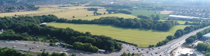
The existing junction is constrained on all sides by privately owned land, which limits the extent of
improvement which can be carried out without recourse to purchasing additional land. Built
development occurs in the north-west quadrant and comprises (progressing north west from the
junction), a petrol filling station, a hotel and industrial buildings.
In the north-west quadrant, the highway boundary runs immediately alongside a petrol filling station
and any moving over of the highway boundary by more than 3m would involve acquisition of at least
some of the land from within the site. It is possible that a modest encroachment (say 3m) into the
M6 JUNCTION 23 HAYDOCK ISLAND WSP
Project No.: 70044810 June 2019
ST. HELENS COUNCIL Page 9 of 42site would not impact on the operation of the site but anything more may well render the site as not being viable. A proposed improvement scheme requiring land beyond the petrol filling station would affect the hotel and several industrial units. Costs of acquisition of any of these units would be high and design of any improvement scheme would try to exclude any of these units. In the north-east quadrant, land has been identified in the St Helens Draft Local Plan Preferred Options as being “Safeguarded Employment Land (removed from Green Belt)”. Improvement schemes being considered include the diversion of A49 Lodge Lane on the north and south sides of the junction. The diversion of the A49 Lodge on the north side of the junction would need to pass through this land but this diversion could also function as an access road servicing the site and enabling any development to connect with the A580. At present it is difficult to envisage how traffic from this development site could connect satisfactorily with the A49 and A580. In the south-east and south-west quadrants, the land has been identified in the St Helens Draft Local Plan Preferred Options as being “Greenbelt”. There may be development aspirations for these areas in the medium term and any proposed highway improvements would have to consider how to minimise the impacts on any development proposals. WSP M6 JUNCTION 23 HAYDOCK ISLAND June 2019 Project No.: 70044810 Page 10 of 42 ST. HELENS COUNCIL
4
DESIGN WORKSHOP – OPTIONS AND
DISCUSSION

                        CONFIDENTIAL
4. DESIGN WORKSHOP – OPTIONS AND DISCUSSION
Following the site visit, draft scheme designs were drawn up and discussed with the clients at the
subsequent progress meetings. These scheme designs were further developed and led to WSP
producing eight major draft scheme proposals for presentation and evaluation at the Workshop. An
additional three options were also presented on the day by other stakeholders.
On 18th July 2018, the design workshop was hosted by WSP and attended by representatives from
St Helens Council, Highways England, Wigan Council, Merseytravel and the Highways England
Area 10 contractor. The workshop commenced with a presentation on the background and
objectives of the scheme as well as details about the model inputs for the study and the forecast
demands at the junction. The existing issues at the junction were then discussed based on the site
visit, the traffic survey information and anecdotal feedback from users. The eleven conceptual
design options, of varying scale and ambition, were then presented and discussed. These options
aimed to cover the three core scheme types identified in the 2017 workshop undertaken by the
partner organisations:
Scheme Type 1: Improvements that could be carried out on Junction 23 itself to provide
additional capacity such as additional lanes;
Scheme Type 2: Improvements or relatively minor new infrastructure on the Liverpool City
Region Key Route Network and Local Road Network in St Helens and Wigan within
approximately 2 miles of the junction that may remove existing local traffic from the junction;
Scheme Type 3: Major new infrastructure on the roads at and approaching the junction to
provide free-flow slip roads and/or grade separated flows.
The workshop report can be in Appendix E which includes sketches, details and discussion on each
of the proposed options.
4.1. Option 1 – Free Flow Links to/from M6
The M6 off-slip roads contribute a large volume of traffic into the circulatory carriageway, causing
congestion particularly during peak times with traffic backing up and blocking traffic lanes on M6.
This Type 3 Option proposes “free flow links” between the A580 and the M6 on some or all the
junction’s quadrants.
The main beneficiaries of the “free flow” links are - M6 southbound to A580 eastbound and M6
northbound to A580 westbound. Both links are restricted by A49 Lodge Lane and would have to be
grade-separated above the A49 or alternatively the A49 would have to be diverted away from the
roundabout. See Option 2. Land take outside highway boundary would be required.
4.2. Option 2 – Diversion of A49 Lodge Lane
This Type 3 Option diverts Lodge Lane away from the junction, connecting with A580 through two
new separate signal controlled junctions. See Section 7 for more details.
4.3. Option 3 – Combine M6 Slip Roads with A49, Remote from the Junction
To reduce conflicts and to provide greater capacity on the gyratory where the M6 slip roads and A49
Lodge Lane join, this Type 3 Option would combine both these roads at new junctions remote from
WSP M6 JUNCTION 23 HAYDOCK ISLAND
June 2019 Project No.: 70044810
Page 12 of 42 ST. HELENS COUNCILthe gyratory. New link roads would be constructed to take traffic from these junctions to the gyratory
where traffic would join through a single point of entry. This would remove entry points onto the
gyratory, reducing the complexity of the junction and increase stacking space.
Works to the M6 mainline would be required moving the point of bifurcation between the motorway
slip road and the M6 mainline further away from J23 and this could include extending existing
structures, both north and south of the junction.
4.4. Option 4 – Junction 24 Improvement: Providing South-Facing Slips
M6 Junction 24 connects the motorway with A58 Liverpool Road. The junction has north facing slip
roads only and traffic cannot leave the M6 northbound, nor join the M6 southbound. Traffic wanting
to make these manoeuvres must use either A49 Lodge Lane / M6 J23 or use the M6 J25. This Type
2 Option would construct south-facing slip roads on the southern side of junction 24.
This scheme requires land on the south side of the junction and impacts severely on properties in
the south-east corner of the junction. Land from the adjacent golf course would also be needed.
Detailed traffic surveys would be required to determine the benefit, but it is likely to be a poor value
scheme due to the high land acquisition costs.
4.5. Option 5 – Widening and Extension of Lanes beneath the M6 Overbridge
The full capacity of the straight-ahead and right-turn lanes in the centre of the roundabout is not
being fully utilised due to lane blockages and tight vehicle manoeuvres. This is particularly evident
when HGVs make right-turn manoeuvres from the A580 towards the M6 because the tight
geometrical layout requires HGVs to queue in the left-hand lane (of the two right-turning lanes) to
make this turn. The tailback of traffic in this left-hand lane, blocks vehicles from entering the right-
hand lane, causing a queue of vehicles across the gyratory and approach lanes.
This Type 1 Option would increase capacity through the centre of the gyratory, by providing four
lanes of traffic through the junction (two straight-ahead and two right-turning) and would also provide
four lanes on both A580 approaches to the roundabout. The scheme would be relatively low cost,
would not cause major disruption during construction, not require any land nor require any major
diversion or alteration of traffic signals, statutory undertakers’ apparatus or drainage. However, the
scheme does not address the congestion and traffic conflicts caused by the M6 slip roads and A49
Lodge lane all converging on the roundabout in close proximity to each other.
This option represents an incremental improvement to the junction by improving the alignment, and
additional traffic capacity for the predominant vehicle movements at the junction – straight-ahead
along the A580 and for right-turns onto the M6.
4.6. Option 6 – Relocation of Straight-Ahead Lanes and Realignment of Right-
Turn Lanes
This Type 1 Option improves traffic flows through the centre of the roundabout by separating and
realigning the straight-ahead and right-turn lanes on both carriageways of the A580. See Section 8
for further details.
4.7. Option 7 – Extension of Roundabout
This Type 1 Option is an extension of Option 6, using the available space between the M6 bridge
supports to segregate flows. Option 7 extends the circulatory carriageway to the east and/or west to
M6 JUNCTION 23 HAYDOCK ISLAND WSP
Project No.: 70044810 June 2019
ST. HELENS COUNCIL Page 13 of 42increase the capacity and improve stacking around the A49 Lodge Lane arms. Alignment of the
right-turn manoeuvre from the A580 onto the M6 could be improved and the M6 on-slip roads could
be realigned to ensure a smoother and more gradual turning manoeuvre to allow more vehicles
through the junction.
This option would require land beyond the highway boundary and is constrained by the existing
Shell petrol station in the north-west quadrant. Dealing with existing traffic during construction would
be difficult and could cause considerable disruption to traffic.
Benefits of this option might not justify the costs given the land take required and the fact it does not
necessarily address key safety issues at the junction nor provide a long-term solution to the capacity
issues.
4.8. Option 8 – Cloverleaf Junction
A full or partial cloverleaf junction, a Type 3 Option, is a large-scale solution for resolving traffic and
congestion issues at M6 J23. The option would be dependent on A49 Lodge Lane being diverted
enabling the roundabout to be removed and ensuring the free flow of traffic for all movements
between the A580 and the M6.
This option requires a large amount of property demolition in the north-west quadrant with the hotel
and the Shell garage affected. The other three quadrants have been identified for potential future
development, and the links would reduce the size and impact on these developable areas.
As an alternative and to reduce the scale and cost of land acquisition, a partial cloverleaf has also
been considered, providing free flow links in the south-west and north-east quadrants, to cater for
the largest flows. Compared to the full cloverleaf option, the advantages are the reduced impact on
potential developable land and no land acquisition in the north-west and south-east quadrants.
However, the relatively lightly trafficked flows from M6 North to A580 East and M6 South to A580
West would have to be accommodated.
The Cloverleaf option is ambitious and expensive but it does facilitate a much larger volume of traffic
and improve the safety of the interchange. If the smaller options do not provide sufficient
improvements when modelled, a long-term solution of this scale may be required.
4.9. Additional Option 1 – Three-Level Grade Separated Junction
This Type 3 Option was presented as a conceptual sketch at the Design Workshop. The scheme
would lower the A580 beneath the existing roundabout enabling the dominant traffic flows (A580
straight-ahead traffic) to travel through the junction without being subject to any form of traffic
control. This option could be combined with the diversion of A49 Lodge Lane, as this would
eliminate the need to connect Lodge Lane directly with A580 at the junction.
This option has the potential to greatly reduce congestion and improve safety but has significant
buildability constraints, particularly due to the construction that would be required beneath the M6
structural piers. This option would be expensive but it represents a feasible, long-term solution
addressing a number of issues at the junction.
4.10. Additional Option 2 – Diverging Diamond Junction
The scheme could be considered as a hybrid of Type 1 and 3 Options and involves traffic crossing
to the opposite side of the road prior to the junction and then back again after the junction. A49
WSP M6 JUNCTION 23 HAYDOCK ISLAND
June 2019 Project No.: 70044810
Page 14 of 42 ST. HELENS COUNCILLodge Lane would need to be diverted on both side of the junction to facilitate this proposal. See
Section 10 for more details.
4.11. Additional Option 3 – Minor Improvements (Signals, Line Markings, Minor
Geometric Improvements)
Either in isolation or in conjunction with other schemes, there are some minor improvements that
could be made at the existing junction to improve capacity and safety:
Review of signals phasing and re-calibration;
Advanced signing installation;
Adjustments to line marking, including modifying the stop lines to ease the issue of limited
stacking space;
Small geometric changes to help turning movements and traffic flow;
Upgrading pedestrian facilities including push button facilities on slip roads.
More informed improvements could be made following receipt of the Post Opening Project
Evaluation report but fundamentally, all these minor improvements are short-term and do not
address the root causes of the problems at the junction.
M6 JUNCTION 23 HAYDOCK ISLAND WSP
Project No.: 70044810 June 2019
ST. HELENS COUNCIL Page 15 of 425 SCORING MATRIX
5. SCORING MATRIX
The workshop group completed a scoring exercise whereby each option was assessed against a
range of cost and benefit metrics such as impact on safety, buildability and environmental impact.
The summary results of this exercise are shown in Table 5-1 below. The complete breakdown of
scores can be found at the end of the workshop report - Appendix E. Note that each score is on a
scale from 1 to 5 where 1 denotes a poor score and a 5 denotes an excellent score.
Table 5-1 – Workshop Score Summary
Option Title Average Score
1 Free Flow Links to/from the M6 2.4
2 Diversion of A49 Lodge Lane 3.4
Combine M6 Slip Roads with A49, remote from the
3 1.7
Junction
Junction 24 Improvement: Provision of South-Facing
4 1.6
Slip Roads
Widening and Extension of Lanes beneath the M6
5 2.9
Overbridge
Relocation of Straight-Ahead Lanes and Realignment
6 3.3
of Right-Turn Lanes
7 Extension of Roundabout 2.3
8 Cloverleaf Junction 2.6
Additional Option 1 Three-Level Grade Separated Junction 3.2
Additional Option 2 Diverging Diamond Junction 3.9
Minor Improvements (Signals, Line Marking, Minor
Additional Option 3 3.6
Improvements)
Based on these scores and their anticipated costs, the following recommendations were made in the
interim report that was issued to the J23 Steering Group for review:
Options 3, 4, 7 and 8 were not to be taken further;
Option 1 and Additional Option 3 were to be taken further, but only in conjunction with other
solutions;
Options 2, 5, 6 and Additional Options 1 and 2 were to be taken forward for further assessment.
5.1. Workshop Conclusions
At the progress meeting held on 26th September and attended by representatives from St Helens
Council, WSP, Highways England and Wigan Council, it was agreed by all parties that WSP would
further consider and assess Option 2 (Divert Lodge Lane), Option 6 (Relocation and Realignment of
Straight-Ahead and Right-Turn Lanes) and the Diverging Diamond proposal.
M6 JUNCTION 23 HAYDOCK ISLAND WSP
Project No.: 70044810 June 2019
ST. HELENS COUNCIL Page 17 of 42One important observation made at the workshop was that the permanent diversion of A49 Lodge Lane may prove to be a fundamental requirement of all other design solutions, either from a capacity or buildability perspective or to facilitate a user-friendly and safe junction arrangement. WSP M6 JUNCTION 23 HAYDOCK ISLAND June 2019 Project No.: 70044810 Page 18 of 42 ST. HELENS COUNCIL
6
MODEL DEVELOPMENT

                    CONFIDENTIAL
6. MODEL DEVELOPMENT
6.1. Approach to Traffic Modelling
Two different model types have been used to inform option development and testing, namely:
The St Helens SATURN Model (SHSM), which is a strategic model that covers the entire St
Helens District and has been used to test the traffic impact of the Local Plan Preferred
Options. For the current study, the model has primarily been used to understand the broad
impact of re-routing through the network as a result of schemes to improve capacity at M6
J23 and to refine the forecasts used in the more detailed local junction models;
Local Junction Models – these have been developed within the TRANSYT software, which,
unlike SHSM, has the ability to simulate complex traffic signals and the interaction between
adjacent signalled junctions.
Full details on the strategic modelling can be found by reference to Appendix F. For the local
junction modelling, the detail can be found in Appendix G.
6.2. Traffic Counts
Traffic flows through M6 J23 were based on the traffic survey undertaken in July 2018. These were
inputted into the TRANSYT models of the existing base and potential improvement options.
In the proposed options where the Lodge Lane arms are proposed to be diverted to either side of
the East Lancashire Road, flows have been redistributed from these arms onto the rest of the local
highway network. A review of the traffic survey data identified the following network peak hours:
Morning Peak Hour = 8:00am to 9:00am (AM) and;
Evening Peak Hour = 5:00pm to 6:00pm (PM).
6.3. Future Year Growth / Assessments
Traffic growth factors were extracted from TEMpro Version 7.2 for the St Helens area. The “Urban”
area and “Motorway” type were chosen to determine the growth factors relating to the SRN junction.
Table 6-1 – TEMpro Forecast Demand Projections
Growth Factors for St Helens 005 Output Area
2018-2023 2018-2033
AM PM AM PM
Urban Motorway 1.0691 1.0674 1.1557 1.1547
6.4. Existing Junction Performance
The existing junction has been modelled using the traffic survey data and validated using surveyed
queue data (including the observations that were made from the drone surveys) to deliver an
assessment of the existing conditions and to provide a comparison of the summary results for the
potential design options. For the purposes of this report, the performance of the existing junction as
well as the potential improvement options has been measured and compared using the metrics of:
WSP M6 JUNCTION 23 HAYDOCK ISLAND
June 2019 Project No.: 70044810
Page 20 of 42 ST. HELENS COUNCIL Total Delay (Passenger Car unit (PCU)-hr / hr) at the junction and;
The Degree of Saturation (DOS) at the junction’s key arms at their respective critical peak period
(AM or PM).
Table 6-2 and Table 6-3 below represent the baseline traffic performance of the junction i.e. how
Junction 23 is projected to perform if no improvement schemes are undertaken.
Typically, whilst a DOS of 100% represents a point where theoretical capacity is met, a DOS of 85%
and over is indicative of a junction (or approach arm) that is beginning to experience capacity
issues, with queues and delays increasing significantly from that point onwards. It can be seen with
reference to the tables below, that in the 2018 base year models, DOS over 85% are experienced
on each approach arm and indeed, for most arms the DOS is over 90% and both Lodge Lane arms
are exceed 100%. The capacity issues are exacerbated at both forecast years, corresponding to
significant increase in the total delay experienced at the junction.
Note that the TRANSYT model has been developed to prioritise overall junction performance and
not the individual performance of key arms. This methodology means that some key arm data
appears counter-intuitive i.e. a reduction in key arm saturation over time, but this is a function of the
manipulation of phasing to optimise overall junction performance.
Table 6-2 – Baseline Junction Performance – “Do Nothing”
AM PM
Total Delay (PCU-hr / hr)
2018 95.00 139.25
2023 128.13 330.22
2033 338.47 852.76
Table 6-3 – Baseline Key Arms Performance – “Do Nothing”
2018 2023 2033
Highest Degree of Saturation (%) (AM or PM peak)
A580 - WB Approach 98 (PM) 108 (PM) 117 (PM)
Lodge Lane N (SB) 102 (PM) 109 (PM) 102 (PM)
M6 SB Off-Slip 84 (AM) 94 (AM) 96 (AM)
A580 - EB Approach 92 (PM) 97 (AM) 126 (PM)
Lodge Lane S (NB) 100 (PM) 109 (PM) 124 (PM)
M6 NB Off-Slip 86 (PM) 89 (PM) 85 (PM)
M6 JUNCTION 23 HAYDOCK ISLAND WSP
Project No.: 70044810 June 2019
ST. HELENS COUNCIL Page 21 of 427 OPTION A – DIVERSION OF A49 LODGE LANE IN ISOLATION
7.     OPTION A – DIVERSION OF A49 LODGE LANE IN ISOLATION

7.1.   Description
       Due to A49 Lodge Lane entering the roundabout in the north-east and south-west quadrants, there
       is limited stacking capacity on the circulatory carriageway in these two areas. As fewer vehicles can
       be stored within these sections of the circulatory carriageway, stationary vehicles must be held on
       the approach arms, resulting in increased queues on these arms. Furthermore, with the existing
       junction consisting of six approach arms, the available green time is allocated across many
       movements and where insufficient green time can be provided, delay increases on the approaches
       to the junction. This is a major issue at the junction. This option proposes to divert Lodge Lane away
       from the junction and to form two separate signal controlled junctions along the A580, either side of
       J23.
       As there is development proposed in the north-east quadrant, two layout options for the north-east
       diversion are proposed, one skirting the perimeter of a proposed development and one running
       through the proposed site. Sketches of design Options A-D are all provided in Appendix H, including
       the two proposed layouts for the north-east Lodge Lane diversion.

7.2.   Discussion
       This option would not only remove traffic from the junction, but also reduce the complexity of the
       junction, increasing the stacking capacity on the circulatory carriageway and enabling the available
       green time to be allocated to the A580 and M6 slip roads. By reducing the number of junction arms
       and thus reducing the complexity of the junction, this option should have a positive impact on safety.
       One constraint on this option is that the land through which Lodge Lane would be diverted is put
       forward for development, and any alignment would need to limit the impact on these developments.
       The design also requires two new signalised junctions, which could affect the flow of traffic along the
       A580.

7.3.   Modelling/Traffic Performance
       Table 7-1 – Option A - Junction Performance

                                                   AM                                PM

                                                        Total Delay (PCU-hr / hr)

                     2023                    82.52 (128.13*)                   223.54 (330.22)

                     2033                   112.59 (338.47)                    346.71 (852.76)

       *Numbers in brackets show the comparison to the “Do Nothing” scenario

       M6 JUNCTION 23 HAYDOCK ISLAND                                                                     WSP
       Project No.: 70044810                                                                        June 2019
       ST. HELENS COUNCIL                                                                        Page 23 of 42
Table 7-2 - Option A - Key Arms Performance
2023 2033
Highest Degree of Saturation (%) (AM or PM peak)
A580 - WB Approach 94 (PM) (108*) 120 (PM) (117)
M6 SB Off-Slip 78 (PM) (94) 84 (PM) (96)
A580 - EB Approach 103 (PM) (97) 98 (PM) (126)
M6 NB Off-Slip 84 (PM) (89) 97 (PM) (85)
*Numbers in brackets show the comparison to the “Do Nothing” scenario
The model indicates that the A580 westbound approach would be operating with a DOS of 120% in
the PM peak by 2033. Several of the other key arms are forecast to be operating near saturation
levels in the peak periods by 2033.
7.4. Estimate of Costs
The costs of this potential option are broken down as follows:
Diversion of Lodge Lane in the south-west quadrant (layout 1): £5.9M
Diversion of Lodge Lane in the north-east quadrant through the Peel site (layout 2): £11.8M
Diversion of Lodge Lane in the north-east quadrant around the perimeter of the Peel site (layout
3): £19.3M
A more detailed breakdown of costs for Options A-D is provided in Appendix I.
7.5. Conclusions
This is a permanent solution with clear benefits for the junction. In isolation, or in conjunction with
other schemes, it is considered fundamental to improving the junction in the medium to long-term. It
could enable “Free-Flow Links” to be constructed at relatively low cost, to take traffic from i) M6
southbound off-slips to A580 eastbound and ii) M6 northbound off-slip road to A580 westbound. By
removing these high-volume traffic movements from the junction, further space would be available to
accommodate traffic on the gyratory and the performance of the junction could considerably improve
The modelling, however, does suggest that in isolation this scheme would not prevent the arms of
the junction from being saturated at peak times if demand increases in accordance with the forecast
demands.
WSP M6 JUNCTION 23 HAYDOCK ISLAND
June 2019 Project No.: 70044810
Page 24 of 42 ST. HELENS COUNCIL8
OPTION B – RELOCATION OF
STRAIGHT-AHEAD LANES AND
REALIGNMENT OF RIGHT-TURN
LANES
CONFIDENTIAL8. OPTION B – RELOCATION OF STRAIGHT-AHEAD LANES AND
REALIGNMENT OF RIGHT-TURN LANES
8.1. Description
This option aims to improve traffic flows through the centre of the roundabout by relocating the
straight-ahead lanes and realigning the right-turn lanes on both the eastbound and westbound
carriageways of the A580.
8.2. Discussion
The 2015 “Pinch Point” scheme provided right-turn lanes from the A580 towards the M6 but the
limited space between the bridge piers to accommodate four lanes of traffic was always going to
constrain the alignment of the turn lanes, forcing right-turning HGVs to make a 90 degree turn
towards the M6 at a very low speed. HGVs can only make this manoeuvre from the left lane of the
two right-turning lanes, often straddling two lanes. This restricts traffic flows and causes congestion.
By removing the straight-ahead lanes from this central span of the overbridge, there would be
additional space available to widen and realign the right-turn lanes. This would enable a much-
improved alignment to be provided, reducing the severity of the turning manoeuvre for right-turning
vehicles. This smoother alignment for the right-turn lanes provided could considerably improve traffic
flows.
Whilst this option increases capacity through the junction and significantly improves the right-turn
movement, relocating the straight-ahead movements reduces the amount of stacking capacity on
the circulatory carriageway for Lodge Lane. Additional works to Lodge Lane (see Option C) or
fundamental changes to the traffic signal timings may be required.
From a safety perspective, this option does not act to simplify what is currently a complex gyratory
carriageway with six arms operating at or near capacity. It does however, improve the turning
movements for right-turning vehicles from the A580.
This option would be relatively easy to construct and would cause minimal disruption during
construction as most of the works would be built offline in unused land beneath the M6 overbridge.
8.3. Modelling/Traffic Performance
Table 8-1 – Option B - Junction Performance
AM PM
Total Delay (PCU-hr / hr)
2023 201.46 (128.13*) 289.19 (330.22)
2033 333.63 (338.47) 424.91 (852.76)
*Numbers in brackets show the comparison to the “Do Nothing” scenario
WSP M6 JUNCTION 23 HAYDOCK ISLAND
June 2019 Project No.: 70044810
Page 26 of 42 ST. HELENS COUNCILKey Arms:
Table 8-2 - Option B - Key Arms Performance
2023 2033
Highest Degree of Saturation (%) (AM or PM peak)
A580 - WB Approach 78 (AM) (108*) 77 (AM) (117)
Lodge Lane N (SB) 79 (PM) (109) 93 (AM) (102)
M6 SB Off-Slip 82 (PM) (94) 89 (PM) (96)
A580 - EB Approach 85 (AM) (97) 96 (AM) (126)
Lodge Lane S (NB) 97 (PM) (109) 114 (PM) (124)
M6 NB Off-Slip 127 (PM) (89) 148 (AM) (85)
*Numbers in brackets show the comparison to the “Do Nothing” scenario
By 2033, the modelling indicates that both the northbound Lodge Lane approach and the M6
northbound off-slip will be operating above capacity in AM and PM peak times with a maximum DOS
of 148%. The remaining junction arms are shown to operate within theoretical capacity.
8.4. Estimate of Costs
The estimated cost of this option is £12.1M.
8.5. Conclusions
Note that this option was modelled with two straight-ahead lanes only but it may be possible to fit
three straight-ahead lanes within this overbridge span. Both the feasibility of this arrangement and
its impact on performance would require further analysis.
In isolation, this option does not represent a significant long-term betterment for the junction.
M6 JUNCTION 23 HAYDOCK ISLAND WSP
Project No.: 70044810 June 2019
ST. HELENS COUNCIL Page 27 of 429 OPTION C – COMBINED A49 LODGE LANE DIVERSION WITH RELOCATION OF STRAIGHT-AHEAD LANES AND REALIGNMENT OF RIGHT-TURN LANES
9. OPTION C – COMBINED A49 LODGE LANE DIVERSION WITH
RELOCATION OF STRAIGHT-AHEAD LANES AND
REALIGNMENT OF RIGHT-TURN LANES
9.1. Description
This option combines Option A and Option B and involves:
Diverting the A49 Lodge Lane arms away from Junction 23 and;
Relocating the straight-ahead lanes and realigning the right-turn lanes on the A580.
9.2. Discussion
The primary inhibitor to the performance of Option B is the short stacking space for vehicles entering
the junction from Lodge Lane. This is exacerbated by the relocation of the A580’s straight-ahead
lanes. Option C addresses this problem by diverting Lodge Lane away from the junction.
This arrangement improves the safety of the junction because it segregates traffic flows and reduces
the conflict points on the roundabout as there are less approaches.
As with Option B, the straight-ahead lanes could be relatively easily relocated and cause minimal
disruption during construction as the works would be in unused land beneath the M6 overbridge.
9.3. Modelling/Traffic Performance
Table 9-1 – Option C - Junction Performance
AM PM
Total Delay (PCU-hr / hr)
2023 71.71 (128.13*) 99.22 (330.22)
2033 85.24 (338.47) 178.58 (852.76)
*Numbers in brackets show the comparison to the “Do Nothing” scenario
Table 9-2 – Option C – Key Arms Performance
2023 2033
Highest Degree of Saturation (%) (AM or PM peak)
A580 - WB Approach 66 (AM) (108*) 87 (PM) (117)
M6 SB Off-Slip 88 (PM) (94) 100 (PM) (96)
A580 - EB Approach 86 (PM) (97) 102 (AM) (126)
M6 NB Off-Slip 81 (PM) (89) 94 (PM) (85)
*Numbers in brackets show the comparison to the “Do Nothing” scenario
M6 JUNCTION 23 HAYDOCK ISLAND WSP
Project No.: 70044810 June 2019
ST. HELENS COUNCIL Page 29 of 42An assessment of the 2033 scenario indicates that the junction would still operate within capacity in
the AM peak, however in the PM peak it is noted that the junction would operate at theoretical
capacity at the M6 southbound off-slip and the A580 eastbound approaches to the junction.
9.4. Estimate of Costs
The estimated cost of Option C is dependent on which layout is chosen for the diversion of Lodge
Lane diversion in the north-east quadrant:
Estimated cost if A49 diverted through proposed site in north-east quadrant: £29.8M
Estimated cost if A49 diverted around perimeter of proposed site in north-east quadrant: £37.3M
9.5. Conclusions
This option represents a medium-term solution with significant benefits.
As with Option B, this option was modelled with two straight-ahead lanes only but it may be possible
to fit three straight-ahead lanes within this overbridge span. Both the feasibility of this arrangement
and its impact on performance would require further analysis.
As with Option A, the diversion of Lodge Lane could facilitate “Free-Flow Links” to be also
constructed at relatively low cost, to take traffic from i) M6 southbound off-slips to A580 eastbound
and ii) M6 northbound off-slip road to A580 westbound.
Option C lends itself to an incremental approach to construction whereby the diversion of A49 Lodge
Lane could be undertaken in isolation first. The junction would then be re-assessed, before
committing to the relocation and realignment of lanes beneath the M6.
WSP M6 JUNCTION 23 HAYDOCK ISLAND
June 2019 Project No.: 70044810
Page 30 of 42 ST. HELENS COUNCIL10
OPTION D – DIVERGING DIAMOND
INTERCHANGE
CONFIDENTIAL10. OPTION D – DIVERGING DIAMOND INTERCHANGE
10.1. Description
The basic concept of this scheme is for the two directions of traffic on the A580 (which are the
dominant flows) to cross to the opposite side of the road prior to the junction and then back again
after the junction. This would enable the high volumes of traffic which make right turns from A580
towards the M6, to make this manoeuvre without having to cut across traffic approaching from the
opposite direction. The number of free flow turning movements would be increased and the number
of signalised intersections would be reduced.
10.2. Discussion
A diverging diamond junction has never been constructed in the UK but has proved to be successful
in a variety of different locations around the world, particularly in the USA where approximately 100
diverging diamond interchanges are operational.
This design would enable the high volumes of traffic which make right turns from A580 towards the
M6, to make this manoeuvre without having to cut across traffic approaching from the opposite
direction. The number of free flow turning movements would be increased and the number of
signalised intersections would be reduced. The scheme has the potential to increase efficiency and
as the number of conflict points is reduced, the scheme also has the potential to reduce accidents.
The scheme would require the diversion of A49 Lodge Lane on both sides of the junction and the
construction of two new signal controlled junctions with A580. It is envisaged that this option could
be constructed within existing highway boundaries (except for the A49 Lodge Lane diversions).
The scheme has the potential to provide a significant improvement to the capacity and flow of the
junction, as it removes the right-turning traffic conflicts towards the M6 slip roads which are a major
safety issue and a source of congestion within the roundabout.
10.3. Modelling/Traffic Performance
Table 10-1 – Option D – Junction Performance
AM PM
Total Delay (PCU-hr / hr)
2023 42.24 (128.13*) 56.30 (330.22)
2033 48.97 (338.47) 68.81 (852.76)
*Numbers in brackets show the comparison to the “Do Nothing” scenario
WSP M6 JUNCTION 23 HAYDOCK ISLAND
June 2019 Project No.: 70044810
Page 32 of 42 ST. HELENS COUNCILTable 10-2 – Option D - Key Arms Performance
2023 2033
Highest Degree of Saturation (%) (AM or PM peak)
A580 - WB Approach 76 (PM) (108*) 85 (PM) (117)
M6 SB Off-Slip 41 (PM) (94) 46 (PM) (96)
A580 - EB Approach 71 (AM) (97) 73 (AM) (126)
M6 NB Off-Slip 47 (PM) (89) 50 (PM) (85)
*Numbers in brackets show the comparison to the “Do Nothing” scenario
With the 3-lane DDI junction in place at M6 J23, the 2033 future year scenario in both AM and PM
peaks would operate within capacity on all arms with a maximum DOS of 85% at the A580 WB
approach to the junction.
It should be noted that, of all the options considered, this is the only option that provides sufficient
capacity to ensure that the junction can operate within capacity until 2033.
10.4. Combined Network Modelling and Sensitivity Testing
In line with options A, B and C, the results above consider each intersection in isolation and assume
a uniform traffic growth across the junction as per the TEMPRO assessment. Further analysis was
undertaken on Option D to consider:
How the DDI option would interact with the proposed Lodge Lane/A580 intersections i.e. platoon
flows and lane swapping;
How this DDI junction would operate if the projected flows were adjusted to account for the origin
and destination flows projected by the SATURN model for St Helens.
The methodology and results of this testing can be found in section 4 of Appendix G.
10.5. Estimate of Costs
The estimated cost of Option D is dependent on which layout is chosen for the diversion of Lodge
Lane in the north-east quadrant:
Estimated cost if A49 diverted through proposed site in north-east quadrant: £32.8M
Estimated cost if A49 diverted around perimeter of proposed site in north-east quadrant: £40.3M
10.6. Conclusions
This option is an innovative solution with the potential to sit within the medium-scale cost band whilst
providing benefits in line with other larger scale options which have been assessed.
Option D (as with option C) lends itself to an incremental approach to construction whereby the
diversion of A49 Lodge Lane could be undertaken in isolation first. The junction would then be re-
assessed, before committing to the diverging diamond scheme.
M6 JUNCTION 23 HAYDOCK ISLAND WSP
Project No.: 70044810 June 2019
ST. HELENS COUNCIL Page 33 of 4211 OPPORTUNITIES FOR ENCOURAGING ALTERNATIVE TRAVEL MODES
11. OPPORTUNITIES FOR ENCOURAGING ALTERNATIVE TRAVEL
MODES
The highway interventions for improving capacity and reliability at the M6 Junction 23 (J23) can be
supplemented by the identification of opportunities for alternative improvements around active travel
or public transport to address local transport demand at this location.
The following key tasks have been undertaken to provide an evidence base for developing a range
of feasible alternative options for reducing local car travel:
Reviewing existing relevant transport studies and data;
Understanding existing sustainable transport options in the area;
Understanding existing and proposed development near the M6 J23 / A580;
A review of potential and proposed transport infrastructure improvements in the St Helens area,
for example, Local Walking and Cycling Infrastructure Plans (LCWIP).
Consulting with key public authorities on relevant studies, data and sustainable transport
improvements;
Understanding current travel patterns and defining the catchment area of existing/forecast local
traffic where alternative options may be feasible e.g. via Census data;
Determination of any funding opportunities which could encourage the use of sustainable
transport modes; and
Determination of any existing or former Travel Plan / Area Travel Plan work undertaken at
employment sites close to M6 J23 / A580.
The deliverability of the key thematic opportunities identified has been assessed in terms of
timescale (quick win, short term < 2 years, medium term 2-5 years and long term 5-10 years), cost
(low cost £35,000) and key risks, as set out in
Table 11-1.
By nature, the industrial area comprises employment uses that operate 24 hours a day, seven days
a week. The shift patterns for staff can therefore create real or perceived barriers to the use of
sustainable modes for the commute to work. The application of a wide range of opportunities
outlined in this report will ensure that the feasibility to encourage existing and new travel demand by
sustainable modes is maximised.
Appendix J provides full details on the assessment of opportunities for encouraging alternative travel
modes.
M6 JUNCTION 23 HAYDOCK ISLAND WSP
Project No.: 70044810 June 2019
ST. HELENS COUNCIL Page 35 of 42Table 11-1 – Alternative Options Delivery Assessment
Option Delivery Delivery Key Risks
Timescale Cost
Accessibility Medium-long Medium - Lack of funding for measures
Improvements High Increasing traffic congestion
exacerbating access issues
Lack of travel planning to promote
the use of access improvements
Lack of public engagement on
measures (facilitates ownership to
encourage use)
Shift times limiting use
Ongoing cross-borough issues
Ongoing connectivity issues
Behaviour Change Quick win / Short Low- Lack of funding
Initiatives for some initiatives Medium Low employer engagement /
Medium for full enthusiasm
impact of some Lack of dedicated employer
initiatives to be resource/management
realised e.g. a car Lack of / poor marketing of
share scheme sustainable travel options
Shift times limiting behaviour change
opportunities
Public Transport Short - Medium Medium - Bus operators control of services
High Poor marketing
Planning / Ongoing Medium - Lack of Council Officer Travel Plan
Enforcement High enforcement
Lack of sustainable development in
line with Local Plan Preferred
Options i.e. effective land-use
planning
Continued high car use despite of
measures / infrastructure
improvements
Effective Promotion Quick win / Low - Requires sustained effective
of Alternative Ongoing Medium marketing strategy at existing and
Options at optimal new development
times (i.e. in line with
new
infrastructure/service
provision)
Travel Plan Quick win - Low - Recruitment of non-local workforce
Management Medium Medium Lack of Employer Senior
Management interest/resource for
Travel Plans
WSP M6 JUNCTION 23 HAYDOCK ISLAND
June 2019 Project No.: 70044810
Page 36 of 42 ST. HELENS COUNCIL12
CONCLUSIONS AND NEXT STEPS
CONFIDENTIAL12. CONCLUSIONS AND NEXT STEPS
12.1. Summary and Conclusions
This study has clearly identified that the existing Junction 23 on M6 suffers from serious operational
and safety issues. Although the Pinch Point Scheme, completed in 2015, has provided some
improvement at the junction, there are still major issues to be addressed, in particular:
Heavy congestion at peak times which causes delay and increased journey times for traffic using
the junction;
Extended queues often develop on all approach arms and on the M6 slip roads, these can back
up and block running lanes on the M6;
A poor accident record, with the junction having the worst road safety record in St Helens and
one of the worst in Merseyside;
Limited facilities for pedestrians and cyclists as the junction presents a daunting obstacle for
these non-motorised road users;
The junction acts as a constraint on development opportunities in the area.
Junctions remote from M6 J23 were identified to determine whether their improvement might
encourage traffic to use alternative routes away from J23, reducing congestion at this junction.
However, after evaluation, it was considered that improvement at these sites would:
Only reduce congestion in the immediate vicinity or;
Provide access onto the A580 from large scale developments, adding to the traffic likely to use
M6 Junction 23 or;
Provide limited benefits at M6 Junction 23, disproportionate to the costs of construction.
Eleven options for improvement at the junction, ranging from under £50k to over £80m were initially
considered. These options were developed and discussed at the Workshop and it was concluded
that many of the proposals would only give short-term improvements. Options were scored at the
Workshop and a post-Workshop Report was produced detailing the schemes and identifying their
merits.
Further evaluation by Steering Group members led to four schemes being considered for more
detailed assessment:
A: Relocation of Straight Ahead Lanes and Realignment of Right-Turn Lanes (ROSAL);
B: Diversion of A49 Lodge Lane on both sides of junction forming new junctions with A580;
C: Combination of Options A and B;
D: Diverging Diamond Interchange (including the diversion of Lodge Lane).
Initial modelling work identified that Option A would not give any significant improvements in
performance as a stand-alone scheme. The conflicting movements and the limited stacking space
for vehicles where M6 slip roads, A49 Lodge Lane, the circulatory section of the roundabout and the
straight-ahead lanes on A580 converge, would always constrain any attempt to improve the
WSP M6 JUNCTION 23 HAYDOCK ISLAND
June 2019 Project No.: 70044810
Page 38 of 42 ST. HELENS COUNCILYou can also read


