Making the invisible visible - the DTM modelling in complex environments - International Society ...
←
→
Page content transcription
If your browser does not render page correctly, please read the page content below
Geomorphometry.org/2015                                                                                                                          Wężyk

      Making the invisible visible – the DTM modelling in
                    complex environments

                                                                       Piotr Wężyk
                                                   Laboratory of Geomatics, DFMGFE, IFRM
                                             Faculty of Forestry, University of Agriculture in Krakow
                                                                  Krakow, Poland
                                                              p.wezyk@ur.krakow.pl

Abstract- Mapping of forested areas and water bodies was very                     layer evergreen dense tree and shrub vegetation are a challenge
limited in the past. Access to such areas with traditional survey                 for detailed modelling of digital terrain models, because of the
techniques (total station, GNSS etc.), analogue/digital                           lack of the survey data referring to the true ground. The
photogrammetry or radar technologies was very limited because of                  traditional photogrammetry approach and the GNSS survey are
the dense and multilayer vegetation, very complex topography,
                                                                                  very limited due to the dense canopy, undergrowth and multipath
swamps, narrow beach and steep cliffs, deep water, etc. Gathered
data by survey or remote sensing, were used for generation of                     signal errors. Water bodies like: sea, lakes or rivers cause serious
digital terrain models (DTM, sometimes with unknown accuracy.                     problems with the measurement of the bottom. Therefore the
Implementation of airborne laser scanning technology (ALS;                        need of the development on state-of-the-art technologies for
LiDAR - Light Detection and Ranging) to monitor complex                           precision mapping and 3D modelling of wide-areas still exist.
environments which are very hard to see by human eye or other                     Nowadays various Remote Sensing technologies like: aerial and
instruments in 3D space - opens new opportunities to identify                     satellite stereo-photogrammetry, radar and especially the
precisely the vertical and horizontal structures, objects and                     Airborne (ALS) and Terrestrial Laser Scanning (TLS)
magnitudes. Use of precision DTM based on ALS point clouds, is                    technology are used for the national-wide, regional and local
now a widely deployed method in many environmental applications
                                                                                  mapping. The precise DTM models besides their role in:
including:    morphometry analyses, landslide            monitoring,
geomorphological and hydrological modelling etc. Dense forest                     geomorphology, archaeology or landslide monitoring are crucial
crown cover and undergrowth is limiting the penetration of laser                  for the quality of the generation of ALS derived products like
beams but now the ground (DTM) can be “seen” very detailed if                     normalised Digital Surface Models (nDSM). Those models
using high density of ALS data performed with narrow nadir-off                    (called also Crown Height Model) are very important e.g. for:
angle and using full waveform as well. The bathymetric scanners                   foresters, ecologists and landscape planers. DTM mapping of
operating with green light, can penetrate the sea or river water and              river and sea bottom using bathymetric scanners can deliver very
can be used for bed mapping. Also the terrestrial laser scanning                  important information concerning the natural environment and
technology (TLS) can be used for 3D point cloud collection and                    different hazards especially when the integration of multi-source
modelling of underground structures (e.g. caves) and later                        information leads to continuous DTM data. Also the using of
integrated with ALS data to generate continuously surfaces of the
                                                                                  TLS and handy scanners opens new possibilities to capture and
DTM and some new “underground DTM’s”.
                                                                                  make 3D models of underground surfaces such as caves or
                                                                                  mines that can be integrated with DTM based on ALS and
                                                                                  spectral information gathered by airborne cameras.
                          I.     INTRODUCTION
                                                                                          II.   COMPLEX ENVIRONMENTS: FOREST AND WATER
Forests and water areas are the basic environments presented on
maps since the early days of cartography, but because of their                        A. DTM in wooded areas
high complexity, they are very difficult for detailed and real                    Modelling of the ground surface in the forest areas has always
mapping. The wooded areas, especially those covered by multi-                     been difficult due to the visibility limitations for traditional

 In: Geomorphometry for Geosciences, Jasiewicz J., Zwoliński Zb., Mitasova H., Hengl T. (eds), 2015. Adam Mickiewicz University in Poznań
 - Institute of Geoecology and Geoinformation, International Society for Geomorphometry, Poznań

                                                                             57
Geomorphometry.org/2015                                                                                                                   Wężyk

measurement methods such as levelling, total stations or even              environment. This technology was awaited for dozens of years.
airborne and terrestrial photogrammetry. Only in clear-cuts,               At first ALS system represented a profiler, which was basically a
deforested areas, post-fire or areas without tall trees alongside          static laser telemeter put aboard the plane, but with the
the roads and other logging routes and trails it was possible to           appearing of technology NAVSTAR-GPS and inertial navigation
establish surveying control lines and refer to them with further,          systems (INS) a technology was made, owing to which ALS
more detailed measurements (mass points, soft and hard break               point cloud is made, covering large areas in a short time [6].
lines, barriers etc). In the forest areas triangulation towers were        Forest ecosystem is, however, a very complicated terrestrial
also constructed as important parts of height measurements                 ecosystem limiting the penetration of the laser beam during its
networks. Gradually the traditional methods of getting                     way to the ground [7]. The registration of subsequent laser
information on digital terrain model (DTM) were supplemented               returns in a tree stand depends on a very large number of factors.
by GNSS techniques, but these, due to the specifics of forest              The number of registered returns in the height profile of the tree
areas (negative influence of dense crown cover, wood biomass               stand, and first of all these reaching the surface of the ground,
on the propagation of signal; multipath errors) they could not             results first of all from the type of the tree stand. Almost all the
provide precise information compared to open areas [1]. The                evergreen coniferous tree species during the whole vegetation
accuracy (RMSEXYZ) of marking co-ordinates with GNSS                       season, basically do not show large differences between all
method under the canopy of oak-pine tree stand (age 140 years;             returns and first returns, or last returns. Thus for the whole year
H=28m, dense crown cover) ranged between 0.10m (receiver                   in coniferous tree stands, almost the same density of the number
CHC-900) trough 0.28m (Trimble 6000 GeoXR) to as much as                   of points reaching the ground while preserving the same
1.94m (TOPCON GRS-1) at RTK observations [2]. The                          scanning density – and in the same way – similar quality of
reference control line in this tree stand was marked with a total          DTM models can be expected. In case of deciduous stands
station series with a very high accuracy referring to the points           (beech stands - Fagus sylvatica L.) covered by ALS flights
measured in the open area in a GNSS measurement session                    during the vegetation season (May 2012, Ojcow National Park;
lasting many hours (post-processing stations ASG-EUPOS; [3]).              OPN; South Poland, Fig. 1) leaves significantly limit the
The limitations in airborne photogrammetry have existed since              penetration of the laser beam in the relation to the ALS ISOK
its beginning and did not disappear with the appearance of                 project flights performed at the end of the growth season (“leaf-
airborne digital cameras or the increase of their resolution               off”; 24. Oct. 2012; Fig. 2). The vegetation period, however
(ground, spectral or radiometric). Even in the situation of                makes possibility to generate digital surface model (DSM; Fig.
making photogrammetric measurements in the "leaf-off" season,              1) of a proper quality, which also does not remain without the
the airborne pictures of deciduous forests are difficult for the           meaning for the examined forest ecosystems. Upper layers of
collection of points on the ground and used in generation of               canopy have higher number of the individual returns of the laser,
DTM. This is because the shadows made by the trunks and                    which causes the limitation of the echo of the signal on the
branches of trees very negatively influence the perception of the          ground caused sometimes high errors in approximated DTM
operator of the photogrammetric station or the work of the                 (Fig. 3; “leaf-on” conditions). About 20-30% laser impulses
algorithm responsible for the matching airborne stereo-images              reaching the ground under forest canopy (“leaf-on”), make good
[4]. Only in the situations of disasters (deforestation of large           input for DTM modelling when properly choose of ALS point
areas with removal of all the trees) it was possible to use                cloud density is done concerning to specific type of relief and
airborne photogrammetry in precise DTM for a few years, until              vegetation (Fig. 4; “leaf-off” conditions). Often dense
a young generation of forest covered the ground densely. Some              undergrowth layer cause that the last ALS returns are registered
solution in DTM generation for large forest areas, was the                 generally not from the real ground but from surface of
application of radar technology (Shuttle Radar Topography                  vegetation what influence DTM with certain elevation error. A
Mission - SRTM in 2000), e.g. model DTED-2 (3 arc) or the                  particularly difficult case is dense vegetation occurring on the
new global data TanDEM-X and TerraSAR-X. Unfortunately the                 rocks, which causes problems for the algorithm looking for the
DTED-2 (SRTM) model in the forested areas often runs above                 lowest LiDAR returns. In this case the problem with the right
the true ground, which results from the influence of biomass of            approximation of DTM appears (Fig. 3) where the rocks
dense old-growth stands on radar propagation. The studies                  (“Krakow Gate”; Fig. 6) are classified as high vegetation (Fig.
showed that the errors of DTED-2 model took place in Central               5) and are not taken to approximation of the ground surface. The
European forest areas, sometimes reach to the half of the tree             maximum DTM RMSE between the “leaf-off” (Fig. 3) and
stand height [5]. The Airborne Laser Scanning (ALS) certainly              “leaf-on” (Fig. 4) arrived over 20m in the height even when the
became an innovative technology in the studies of forest

                                                                      58
Geomorphometry.org/2015
Wężyk
point cloud density in vegetation errors was 3 times higher (12 (nature reserves) or silviculture treatments applied by the
pts/m2). foresters. The crown cover is determined mainly by light
requirements of the species and the mutual impact of the trees
fighting for the space to live. In the situation of a great
defoliation of trees (the fall of the LAI value), which is
connected with their health status, the generated DTM are
theoretically more accurate, but in some situations the growing
access of light to the bottom tree stand causes the appearance of
a dense layer of the ground cover or the undergrowth, making it
more difficult to model the ground. To generate precise DTM
models, ALS technologies in the deciduous stands should be
Figure 1. DSM of the “Krakow Gate” Figure 2. DSM of the “Krakow Gate”
in Ojców NP in Ojców NP
perform in late autumn or winter (if there is no snow cover
(May 2012; OPN_ALS: 12 pts/m2). (Oct. 2012; ISOK_ALS 4 pts/m2). under trees). Other elements influencing the limitation of the
number ALS points reaching the ground and their correct
detection are: the nests of birds colonies, mistletoes, lichens,
cones, acorns, clusters of fruit (in particular in the years of the
abundance of seeds) or the occurrence of trunks and branches
broken after hurricanes (microstructure). Single rocks or stones
and their clusters can often make problems with generating
proper DTM, which first of all results from the systematic
approach to the approximated ground, and, on the other hand,
Figure 3. DTM of the “Krakow Gate” Figure 4. Correct DTM of the make the work of algorithms detecting the ground more
in Ojców NP with errors. “Krakow Gate” in Ojców NP
(May 2012; OPN_ALS: 12 pts/m2). (Oct. 2012; ISOK_ALS 4 pts/m2).
difficult, because of the shapes (e.g. round rocks in the river
bed). The remaining elements or objects connected with DTM
modelling in the forest areas are firmly connected with
archaeology and the military remains (soil-made defence
constructions: trenches, bunkers, war cemeteries, mass graves,
remains after Nazi death camps etc.). It is estimated that in forest
areas in Poland there are at least several thousand still
undiscovered archaeological sites including: kurgans, hill forts,
which are usually the element of DTM modelled from ALS data.
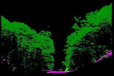
Figure 5. Wrong rock/ground classify- Figure 6 . Cross section through
cation. OPN_ALS point cloud correct classified ISOK_ALS point
(May 2012; 12 pts/m2). cloud. (Oct. 2012; 4 pts/m2). B. Underground
Another space invisible for the human eyes, even with the
Other authors in HIGH-SCAN project (point density 10 pts/m 2) application of ALS are the objects under the surface of the
reported RMSE in wooded areas on the level between 22 and 40 ground or DTM. They can include: caves and cavities after the
cm. Also the crown density was a crucial factor influencing the exploitation of resources (coal, silver, gold, salt etc.).
DTM RMSE showing the 14 cm in clear cut areas, 18 cm for Contemporary technologies of terrestrial laser scanning (TLS)
lightly thinning forest and 29 cm for uncut old-growth forests and surveying (total stations + GNSS) not only allow getting full
[8]. precise information, i.e. 3D cloud of TLS points, but also their
Additionally factors influencing the DTM quality in the wooded integration with the ALS data. Due to this we obtain a
areas can be: the lying dead wood, dense crown cover or continuous surface of „ground” under the real ground, which
windthrow areas after the hurricane disaster. It happens that the makes certain problems, even with the professional
lying stems due to round shapes of trunks and tree crowns lead nomenclature. The example of such ALS integration can be both
to the error in the ground detection algorithm and are counted to mobile laser scanning (MLS) or TLS data of underground car
the triangles of TIN and as a result to DTM. parks under the buildings or in rocks, tunnels in the mountains,
Horizontal and vertical crown cover of subsequent forest storeys but also caves (e.g. the “Łokietek Cave” in the Ojców NP). The
results from preserving the natural character of the ecosystem integration very accurately allows non-invasive volumetric
59Geomorphometry.org/2015
Wężyk
measurements or making profiles and first of all defining in the REFERENCES
distances between subsequent galleries or chambers of mines or [1] Ordóñez Galána C., Rodríguez-Pérezb J.R., Martínez Torresc J., García
caves in 3D, including their distance to the real ground. Such a Nietod P.J., 2011. “Analysis of the influence of forest environments on the
precise information obtained by the integration with ALS in the accuracy of GPS measurements by using genetic algorithms”, In
Mathematical and Computer Modelling. Mathematical models of addictive
same system of co-ordinates gives the possibility of not only behaviour, medicine & engineering. Volume 54, Issues 7–8, October 2011,
wonderful visualization for the needs of tourist information or pp. 1829–1834.
the plans of protective tasks, but also undertaking all the rescue [2] Szostak M. and Wężyk P., 2013. “GNNS measurements in forest
operations by respective services (e.g. making a rescue corridor). environment using various receivers and measurement modes”, In Archive
of Photogrammetry, Cartography and Remote Sensing, Vol. 25, pp. 217-
C. The bottom of the water bodies 231.
Until recently the only way to know and visualize the sea bed [3] Wężyk P., 2012. The integration of the Terrestrial and Airborne Laser
Scanning technologies in the semi-automated process of retrieving selected
was the application of sonar technologies. Today there is trees and forest stand parameters. Ambiencia, Vol. 8; 4: 533-548,
however an alternative of using airborne laser scanning i.e. so- Unicentro, Parana, Brasil.
called bathymetric scanners. They vary technologically in the
[4] White, J. et al., 2013. The Utility of Image-Based Point Clouds for Forest
length of the applied light (green e.g. 532nm like VQ-880-G Inventory: A Comparison with Airborne Laser Scanning. Forests, 4(3), pp.
from RIEGL) from typical topographic scanners used to obtain 518–536.
information of the objects on the ground (close NIR; e.g. 1550 [5] Wężyk P., de Kok R., Świąder A., 2005. Empowered forest GIS – cross
nm like LMS-Q680i from RIEGL). Bathymetric scanners validation of SRTM and optical data. Remote Sensing of Environment.
[In:] Olsson H. (Ed.) Rapport 8b. ForestSat 2005 in Boras. National Board
usually are able to penetrate up to the depth of several dozen of Forestry, Sweden: 91-96.
metres (max. 40-50 m). Of course, many conditions have to be [6] Renslow M. S., 2014. Manual of Airborne Topographic LiDAR.
fulfilled, such as: proper water transparency (connected with the [7] Heritage G., Large A., 2009. Laser scanning – evolution of the discipline.
suspension, presence of: waves or water foam, algae or plankton In: Heritage G., Large A., (Eds.) 2009. Laser Scanning for the
or even fish – to allow the laser beam reach the bottom and Environmental Sciences. Blackwell Publishing Ltd.
return to the detector aboard the aircraft or helicopter. Such [8] Hyppä J., Hyppä H., Yu X., Kaartinen H., Kukko A., Holopainen M., 2008.
solution gives wonderful possibilities of generating a continuous Forest inventory using small-footprint airborne LiDAR. In: Shan J., Toth
C.K. (Eds.) 2008. Topographic Laser Ranging and Scanning: Principles
DTM runs through bank, cliff [9] and near shore which so far and Processing. CRC Press.
has been rather difficult to verify in the water bodies [9] Dudzińska-Nowak J., Wężyk P., 2014. Volumetric changes of a soft cliff
coast 2008-2012 based on DTM from airborne laser scanning (Wolin
ACKNOWLEDGMENT Island, southern Baltic Sea). In: Green, A.N. and Cooper, J.A.G. (eds.),
Proceedings 13th International Coastal Symposium (Durban, South
Special thanks to the Director of the Ojców National Park Africa), Journal of Coastal Research, Special Issue No. 66, pp. 59-64.
(Poland) for the free access to the ALS point cloud data from
May 2012 and to the Main Office of Geodesy and Cartography
(GUGiK in Warsaw, Poland) for free of charge access to ALS
data (point cloud, DTM, DSM) preformed in frame of the ISOK
project.
60You can also read