TYPHOON YOLANDA COMPREHENSIVE REPORT - QUIAPO CHURCH DISASTER RISK REDUCTION AND MANAGEMENT MINISTRY (QCDRRM) (Technical and Needs Assessment)
←
→
Page content transcription
If your browser does not render page correctly, please read the page content below
TYPHOON YOLANDA
              COMPREHENSIVE REPORT
           (Technical and Needs Assessment)

                                  Prepared by:

QUIAPO CHURCH DISASTER RISK REDUCTION
  AND MANAGEMENT MINISTRY (QCDRRM)

                               16 November 2013

Quiapo Church Disaster Risk Reduction and Management Ministry   Page 1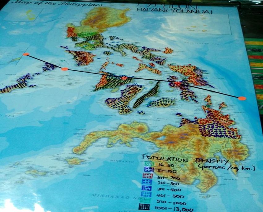
BACKGROUND
Typhoon Haiyan (locally known as Yolanda), considered one of the strongest
tropical storms ever, made landfall in the Philippines early November 8 and caused
catastrophic damage.
The chronology of events:
November 6, 2013
Typhoon East of Mindanao entered the Philippine Area of Responsibility (PAR). It
was named “Yolanda”
November 7, 2013
Typhoon “Yolanda” intensified as it continued to move West Northwest towards
Eastern Visayas maintaining its intensity
In the afternoon, Typhoon “Yolanda” slightly accelerated and maintained its
strength and course
November 8, 2013
At 4:40 AM, Typhoon “Yolanda ” made its 1 st landfall over Guiuan, Eastern
Samar
it further moved as it made its 2 nd landfall over Tolosa, Leyte at 7:00am and its
3rd landfall over Daanbantayan, Cebu at about 9:40AM.
At 10:40 AM, TY “Yolanda” made its 4 th landfall over Bantayan Island, Cebu and
by 12:00NN made its 5th landfall over Concepcion, Iloilo
In the afternoon, it maintained its strength as it approached the Calamian Group
of Islands
At 8:00PM, it made its 6th landfall over Busuanga, Palawan
Typhoon Yolanda slightly weakened as it moved towards the West Philippine
Sea.
November 9, 2013
Typhoon “Yolanda” weakened as it continued to traverse over the West
Philippines Sea and at 3:30PM, it was reported to be outside PAR.
A quick analysis of the image shows that the size of the typhoon based roughly on
the visual circular motion close to the center and the presence of strong convective
storm clouds (as indicated by the bright white colors) is about 610.5 kilometers
horizontally and 721.5 km vertically (Figure 1).
Quiapo Church Disaster Risk Reduction and Management Ministry Page 2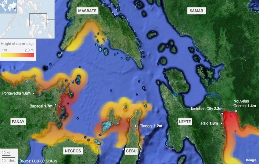
Figure 1. Size estimate of enhanced IR image of TY Yolanda (Haiyan) from CIMSS-SSEC &
Univ. Wisconsin. Satellite Image courtesy of CIMSS-SSEC & Univ. Wisconsin from
http://tropic.ssec.wisc.edu.

Figure 2. Public Storm Warning Signals via PAGASA for the Typhoon Yolanda

                                                                PSWS #1: Winds of 30-60
                                                                kph may be expected in at
                                                                least 36 hours

                                                                PSWS #2: Winds of greater
                                                                than 60 kph and up to 100
                                                                kph may be expected in at
                                                                least 24 hours

                                                                PSWS #3: Winds of greater
                                                                than 100 kph up to 185 kph
                                                                may be expected in at least
                                                                18 hours.

                                                                PSWS #4: Very strong winds
                                                                of more than 185 kph may be
                                                                expected in at least 12
                                                                hours.

Quiapo Church Disaster Risk Reduction and Management Ministry                          Page 3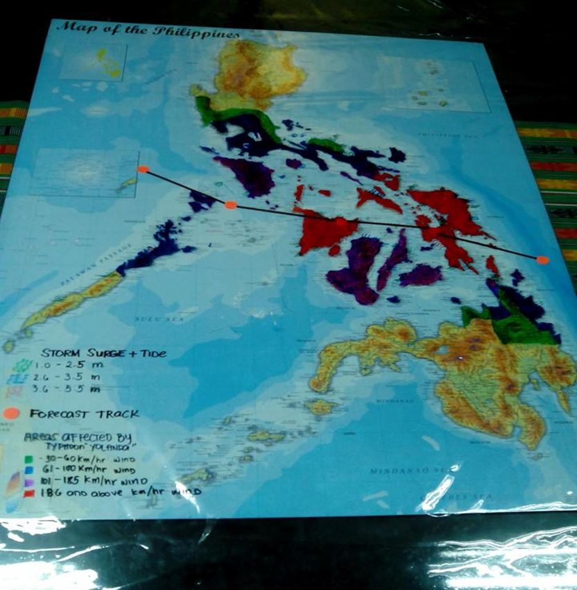
With wind speeds of 268 kph, TY Yolanda is a Category 5 hurricane according to
the Saffir-Simpson Hurricane Wind Scale (Table 1). Category 5 is also known as a
“supertyphoon”. As cited in Manila Observatory’s report, the Saffir-Simpson scale is a 1
to 5 rating based on a hurricane’s sustained wind speed that is used to estimate
potential damages. Typhoons that reach Category 3 and above pose significant risks of
loss of lives as well as causing major losses and damages. The difference between
PAGASA and Joint Typhoon Warning Center reported winds speeds are due to Joint
Typhoon Warning Center (JTWC) reporting winds speeds recorded at 1-minute average
while PAGASA reports 10- minute average.

Table 1. Saffir-Simpson **Hurricane Wind Scale.

  Category          Sustained Winds                Types of Damage Due to Hurricane Winds
     1                 74-95 mph             Very dangerous winds will produce some damage: Well-
                        64-82 kt             constructed frame homes could have damage to roof,
                      119-153 km/h           shingles, vinyl siding and gutters. Large branches of trees
                                             will snap and shallowly rooted trees may be toppled.
                                             Extensive damage to power lines and poles likely will result
                                             in power outages that could last a few to several days.
      2                 96-110 mph           Extremely dangerous winds will cause extensive damage:
                           83-95 kt          Well-constructed frame homes could sustain major roof
                      154-177 km/h           and siding damage. Many shallowly rooted trees will be
                                             snapped or uprooted and block numerous roads. Near-total
                                             power loss is expected with outages that could last from
                                             several days to weeks.
      3                111-129   mph         Devastating damage will occur: Well-built framed homes
   (major)                96-112 kt          may incur major damage or removal of roof decking and
                      178-208 km/h           gable ends. Many trees will be snapped or uprooted,
                                             blocking numerous roads. Electricity and water will be
                                             unavailable for several days to weeks after the storm
                                             passes.
      4                130-156 mph           Catastrophic damage will occur: Well-built framed homes
   (major)               113-136  kt         can sustain severe damage with loss of most of the roof
                      209-251 km/h           structure and/or some exterior walls. Most trees will be
                                             snapped or uprooted and power poles downed. Fallen trees
                                             and power poles will isolate residential areas. Power
                                             outages will last weeks to possibly months. Most of the
                                             area will be uninhabitable for weeks or months.
      5             157  mph   or higher     Catastrophic damage will occur: A high percentage of
   (major)           137 kt or higher        framed homes will be destroyed, with total roof failure
                    252 km/h or higher       and wall collapse. Fallen trees and power poles will isolate
                                             residential areas. Power outages will last for weeks to
                                             possibly months. Most of the area will be uninhabitable
                                             for weeks or months.
**Hurricane is the name for a cyclone found in the North Atlantic Ocean, or the NE Pacific Ocean while
typhoon is the name for tropical cyclones in the NW Pacific Ocean.

Quiapo Church Disaster Risk Reduction and Management Ministry                                    Page 4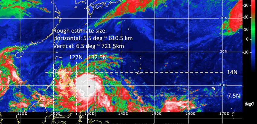
According to the US National Oceanic and Atmospheric Administration (NOAA),
catastrophic damage will occur with a Category 5 hurricane. A high percentage of
framed homes will be destroyed, with total roof failure and wall collapse. Fallen trees
and power poles will isolate residential areas. PAGASA Weather Division OIC Robert
Sawi says that there may be very few trees left un-toppled in the path of TY Yolanda
should it maintain its very high sustained wind speeds. The US NOAA information
further states that power outages will last for weeks to possibly months. Most of the
area will be uninhabitable for weeks or months.

       In the past years, several Categories 4 and 5 typhoons have made landfall in the
Philippines. Some of these Categories 4 and 5 typhoons, namely Rosing, Reming
Sisang, and Sening have been the most destructive in the Philippines. Most have
primarily affected the Bicol region and Southern Luzon; however, the other Category 5
typhoons primarily affected the Visayas regions. The last Category 5 typhoon was TY
Pablo (Bopha), which made landfall in eastern Mindanao and caused over a thousand
deaths.

Storm Surge

       According to PAGASA, a storm surge is an abnormal rise of water due to a
tropical cyclone and it is an oceanic event responding to meteorological driving forces.

                                                        Potentially    disastrous   surges
                                                        occur along coasts with low-lying
                                                        terrain    that    allows    inland
                                                        inundation, or across inland water
                                                        bodies such as bays, estuaries,
                                                        lakes and rivers. For riverine
                                                        situations, the surge is sea water
                                                        moving up the river. A fresh water
                                                        flooding moving down a river due
                                                        to rain generally occurs days after
                                                        a storm event and is not
                                                        considered a storm surge. For a
                                                        typical storm, the surge affects
                                                        about 160 km of coastline for a
                                                        period of several hours. Larger
                                                        storms that are moving slowly
            Photo from www.globalpost.com               may impact considerably longer
                                                        stretches of coastline.

Quiapo Church Disaster Risk Reduction and Management Ministry                       Page 5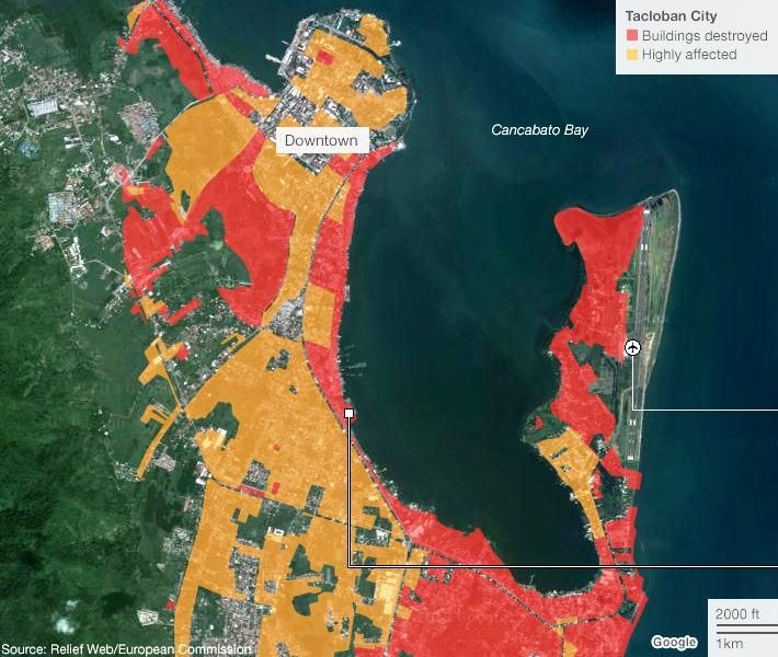
Figure 3. Storm Surge Map-TY Yolanda

The strong winds whipped up by Typhoon Yolanda also contributed to a storm surge,
which sent a wall of water crashing through some low-lying areas. The storm surge
reached its height at Tacloban. According to the calculations of Global Disaster Alert
and Coordination System (GDACS), the height of the storm surge in Tacloban reached
2.3m but local conditions will have meant the actual level was far higher. According to
the data released by Project NOAH, the storm surge + tide measurement of Ormoc,
Leyte reached up to 5.2m. The storm surge also affected other islands on the typhoon
path, though the levels recorded were not as high.

                                       EFFECTS
Affected Population

A total of 1,962,898 families or 9,073,804 persons were affected in 9,303 barangays
in 44 provinces, 536 municipalities and 55 cities of Regions IV-A, IV-B, V, VI, VII,
VIII, X, XI, and CARAGA.

Quiapo Church Disaster Risk Reduction and Management Ministry                    Page 6
Out of the total affected, 405,179 families or 1,910,547 persons were displaced and served both inside and outside evacuation centers. Inside 1,142 evacuation centers: 86,909 families or 422,290 persons Outside evacuation centers: 318,270 families or 1,488,257 persons Figure 4 shows the photo of the map plotted by QCDRRM on affected areas. Figure 4. Map of Affected Areas-TY Yolanda Quiapo Church Disaster Risk Reduction and Management Ministry Page 7
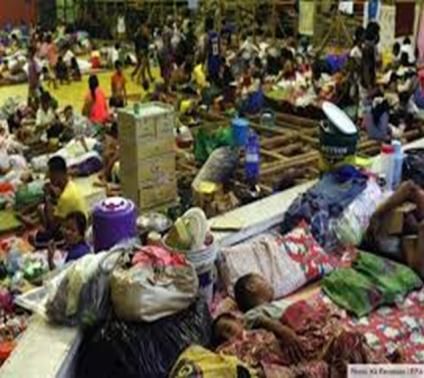
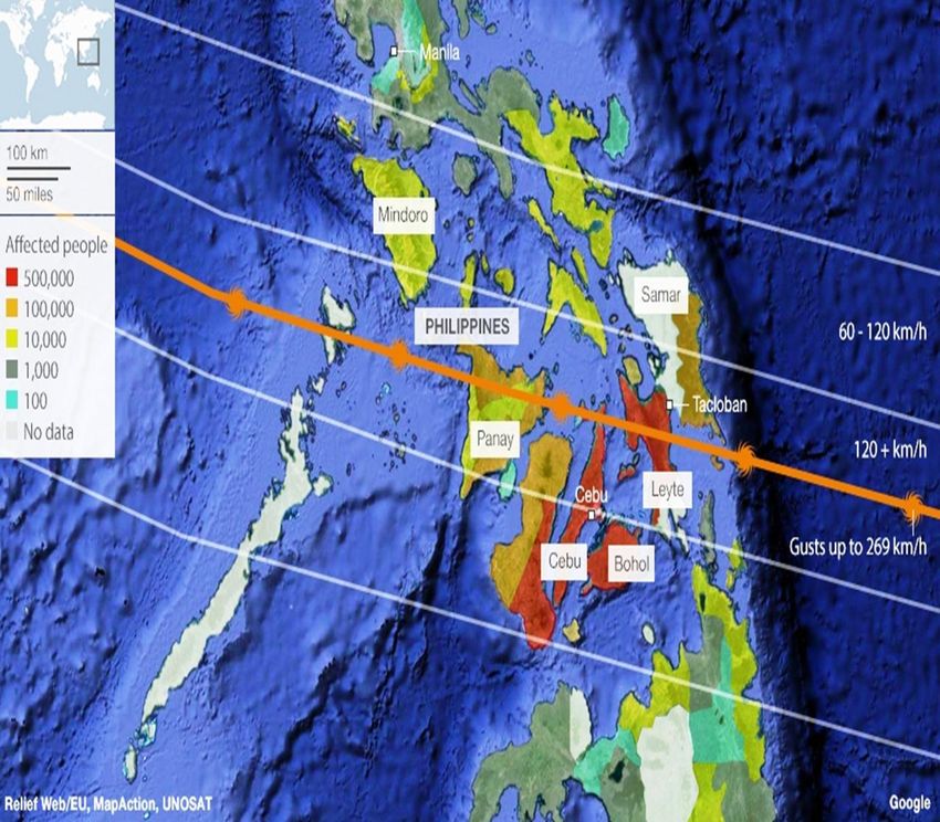
Figure 5 shows some of the areas worst affected by the typhoon, like the islands of
Leyte and Cebu lying closest to the typhoon’s path.

There was an estimate of the numbers of people affected in each province. It says
Tacloban City in Leyte province has been devastated, with most houses destroyed. In
total, 670,000 people are said to have been displaced - about 55% of them are living in
evacuation centers.

Figure 5. Map of Affected Areas and Affected Population-TY Yolanda

Quiapo Church Disaster Risk Reduction and Management Ministry                    Page 8
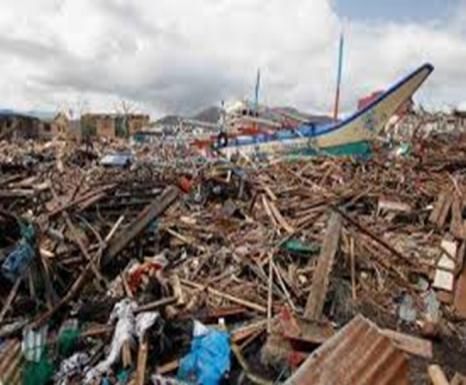
Figure 6. Population density layer-TY Yolanda

Figure 6 shows the population density in the Philippines based on the 2010 NSO
census along with the typhoon track. The most densely populated areas in the typhoon
pathway are Cebu and Iloilo. This means that a large number of people (1,001-13,000
people per square km.), infrastructure and property, especially in urban areas were
exposed to Typhoon Yolanda.

Casualties

As of November 16, 2013, 6:00AM, 3,633 individuals were reported dead, 12,487
injured and 1,179 are still missing.

Quiapo Church Disaster Risk Reduction and Management Ministry                 Page 9

The combined force of the typhoon and storm surge devastated Tacloban, a city of with
a population of more than 220,000.

Access has been limited to most affected areas due to damaged roads, fallen trees and
debris which continue to hamper the humanitarian relief operations.

Figure 7. Map of Tacloban City-TY Yolanda

Quiapo Church Disaster Risk Reduction and Management Ministry                 Page 10
NEEDS ASSESSMENT
The following are the identified and integrated need aspects and the constraints
and gaps for every need. The immediate response should be assessed and done
according to the capacity of each organization.
Early Recovery
Needs:
Main roads are clogged with debris, cutting off remote areas and markets away
from the population centres. There are reports that commodity prices are frozen
due to the disruption in supply of goods.
Constraints:
Debris clearing is a priority with additional aspects to be established, such as an
overall debris management plan and local project partners.
A coordinated market analysis is required to assess the methodology and
standards for cash for work
Evacuation
Needs:
Currently, 1,028 evacuation centers are serving 78,476 families or 380,552
people and 236,460 families or 1,106,488 people are outside evacuation centers.
Constraints:
Access constraints continue to hamper delivery of service and relief items to
some evacuation centres in Regionx VI, VII and VIII.
Emergency Shelter
Needs:
Based on initial data, 243,595 houses are damaged (131,106 are totally
destroyed and 112,489 partially damaged).
There is an urgent need for tarpaulins, tents and non-food items.
A cross-cluster approach is required to institute early recovery activities that feed
into shelter projects, such as debris removal, salvaging coco lumber, and
construction of transitional and semi-permanent shelters.
Constraints:
Quiapo Church Disaster Risk Reduction and Management Ministry Page 11 Main challenges are the cost of transportation and the lack of adequate logistics
and procurement pipelines.
Food Security
Needs:
A total of more than 9 million people are in need of food assistance.
Constraints:
The food distribution system requires enhancement to facilitate faster service
delivery.
Resources are overstretched as organizations are also responding to the Bohol
and Zamboanga emergencies.
Health
Needs:
Health infrastructures are severely damaged in the worst affected areas and
medical supplies are low.
According to NDRRMC, 3,853 people have been injured with numbers expected
to rise as more areas become accessible.
According to the Assistant Secretary of the Department of Health, WASH
facilities, measles vaccination campaigns and restoration of cold chain facilities
are priorities
.An oral polio vaccination campaign is necessary but is hampered by lack of cold
chain capacity.
Emergency surveillance systems needs to be established. The population is at
increased risk of tetanus as well as outbreaks of acute respiratory infections,
measles, leptospirosis and typhoid fever.
Constraints:
Establishing temporary points for delivery of health services is critical as
infrastructure is damaged and people do not have access to medical care.
Medical teams require fuel, water purification and safe accommodation.
The breakdown in communication facilities in many affected areas has hampered
reporting and planning for reproductive health activities
Emergency Telecommunications
Constraint:
Quiapo Church Disaster Risk Reduction and Management Ministry Page 12 Fuel shortage may hamper sustained operation of the generators for the
provision of ETC services.
Education
Needs:
Classes are not functional in the worst affected areas due to severe damage to
school buildings. Tents are needed to establish learning spaces and tarpaulin
sheets to cover damaged roofs.
Community-led debris clearance from school areas, tracking school age children
in affected areas, psychosocial support services and replacement of damaged or
lost teaching and learning materials are priorities.
Constraint:
A lack of accessibility impedes decision making processes as there is no
information on the status of educational institutions and day care centers.
Nutrition
Needs:
At-risk groups amongst the displaced in evacuation centers include an estimated
112,000 children aged between 0 to 59 months and 70,000 pregnant and
lactating women who urgently require nutrition assistance.
Constraints:
Limited disaggregated data for children aged between 0 to 59 months and
pregnant and lactating women is hampering planning processes.
Funding and logistics resources are required for assessments and response
mechanisms to function.
Water, Sanitation and Hygiene
Needs:
Damaged water systems are causing limited or no water supply in affected
areas.
Water kits, hygiene kits and large generator sets for water systems and portable
treatment units are needed.
Quiapo Church Disaster Risk Reduction and Management Ministry Page 13 According to NDRRMC, 239 municipalities do not have electricity as of
November 13. Water systems in these areas may not be fully operational as
they often rely on power to pump water.
Constraints:
There are limited fuel supplies for generator systems to pump water and for
transport of WASH supplies and personnel.
Security and access issues are delaying the transport of supplies and equipment.
Livelihood
Needs:
An estimated 9 million people are affected across nine regions and 44 provinces
due to loss of livelihoods and essential infrastructure. Of these, around 2.1 million
people were engaged in vulnerable forms of employment.
Of highest priority are emergency income-generating activities which can also
align with key rehabilitation and reconstruction needs.
Constraints:
Cluster partners are stretched due to the scale of the disaster.
Extensive destruction to key public and government infrastructure including,
livelihood infrastructure.
Lack of communications, power and blocked transport routes make travel and
information management difficult.
Protection
Needs:
Family tracing and reunification of separated families is urgently needed.
The lack of electricity and lighting increases protection risk among internally
displaced people (IDPs). Women and children are particularly at risk at night.
Women and children are traumatized and will require stress debriefing.
Children and women have started to beg for donations on the streets.
Partners reported cases of sexual violence in severely hit areas including one
alleged rape case in Tacloban City.
Mechanisms to respond to GBV cases at the provincial and municipal levels
need to be restored.
Quiapo Church Disaster Risk Reduction and Management Ministry Page 14 Partners reported wide spread looting and a breakdown of law and order in
some affected areas.
There have been reported attacks on relief convoys by armed groups.
There is limited specialized psychosocial and health services for pregnant and
lactating mothers.
Constraints:
Disruption of Gender Based Violence (GBV) reporting and prevention services.
The total number of IDPs requiring assistance is unverified.
In evacuation centers, there is a lack of law enforcement presence especially
female police officers.
Communications with Communities
Constraints:
Six days after typhoon Yolanda, no additional radio networks or newspapers
have been set up to communicate with disaster affected communities.
Correspondents and international news agencies have been hampered by poor
access to internet.
Restoration of the telecom networks has been slow due to the large volume of
debris.
Logistics
Constraints:
There is limited infrastructure in Tacloban to receive, store and handle goods.
Air traffic congestion at Manila and Tacloban airports is causing flight delays.
There is limited local trucking capacity in Leyte to transport the large volume of
incoming aid.
CONCLUSIONS AND RECOMMENDATIONS
According to the analysis of information and as well as socioeconomic data
(population density), typhoon Yolanda has caused massive destruction and loss of lives
especially in provinces in Visayas and islands in Southern Luzon, as well as parts of
Northern Mindanao. Some provinces like Cebu and Iloilo have the highest population
density and thus high number of people and assets were exposed.
Quiapo Church Disaster Risk Reduction and Management Ministry Page 15Typhoon Yolanda was very large in terms of diameter (approx. 600 km) and had
high sustained wind speeds. The typhoon also caused flash floods and storm surge and
other associated hazards especially in coastal areas and low-lying areas.
It is advised that the public should continuously monitor for updates. The needs
assessment should be considered to help all those affected by this typhoon. The
constraints must be considered so the needs can be addressed properly.
SOURCES:
PAGASA (www.pagasa.dost.gov.ph)
NDRRMC Situational Reports-Effects of Typhoon Yolanda (www.ndrrmc.gov.ph)
Project NOAH (www.noah.dost.gov.ph)
The Manila Observatory (www.observatory.ph)
NASA (http://www.nasa.gov/content/11-w-north-pacific-ocean/#.UgeFGBZCrbw)
United Nations Office for the Coordination of Humanitarian Affairs
ABS-CBN News (http://www.abs-cbnnews.com/nation/regions/11/06/13/yolanda-
category-5-super-typhoon-us-experts )
GMA News Online
(http://www.gmanetwork.com/news/story/334972/news/world/international-disaster-
relief-agencies-mobilize-to-help-yolanda-survivors)
National Oceanic and Atmospheric Administration, United States National Weather
Service (http://www.nhc.noaa.gov/aboutsshws.php)
Official Gazette of the Republic of the Philippines (www.gov.ph)
Weather Philippines (www.weather.com.ph)
BBC News (www.bbc.co.uk)
Google Earth (earth.google.com)
Relief Web (http://reliefweb.int/report/philippines/statement-international-assistance-
victims-typhoon-yolanda)
Quiapo Church Disaster Risk Reduction and Management Ministry Page 16You can also read