Quantification of One-Year Gypsy Moth Defoliation Extent in Wonju, Korea, Using Landsat Satellite Images - MDPI
←
→
Page content transcription
If your browser does not render page correctly, please read the page content below
Communication
Quantification of One-Year Gypsy Moth Defoliation Extent in
Wonju, Korea, Using Landsat Satellite Images
Won-IL Choi *, Eun-Sook Kim, Soon-Jin Yun, Jong-Hwan Lim and Ye-Eun Kim

                                          Division of Forest Ecology, National Institute of Forest Science, 57 Hoegi-ro Dongdae mun-gu,
                                          Seoul 130-712, Korea; drummer12@korea.kr (E.-S.K.); yunsj86@korea.kr (S.-J.Y.); limjh@korea.kr (J.-H.L.);
                                          yaeeun0910@naver.com (Y.-E.K.)
                                          * Correspondence: wchoi71@korea.kr; Tel.: +82-(2)-961-2604; Fax: +82-(2)-961-2629

                                          Abstract: We quantified the extent and severity of Asian gypsy moth (Lymantria dispar) defoliation in
                                          Wonju, Korea, from May to early June in 2020. Landsat images were collected covering Wonju and
                                          the surrounding area in June from 2017 to 2020. Forest damage was evaluated based on differences
                                          between the Normalized Difference Moisture Index (NDMI) from images acquired in 8 June 2020
                                          and the prior mean NDMI estimated from images in June from 2017 to 2019. The values of NDMI
                                          ranged from −1 to 1, where values closer to 1 meant higher canopy cover. The NDMI values for
                                          7825 ha of forests were reduced by more than 0.05 compared to the mean NDMI values for the prior
                                          3 years (2017 to 2019). The NDMI values of 1350 ha of forests were reduced by >0.125 to 0.2, and the
                                          NDMI values for another 656 ha were reduced by more than 0.2. A field survey showed that these
                                          forests were defoliated by gypsy moth and that forests with NDMI reductions of more than 0.2 were
                                          heavily defoliated by gypsy moth. A 311 ha area of Japanese larch (Larix kaempferi) was severely
                                damaged by gypsy moth and the proportion of larch damaged was higher than that of other tree

                                          species. This intense damage to larch suggests that gypsy moths preferentially attack Japanese larch
Citation: Choi, W.-I.; Kim, E.-S.; Yun,   in Wonju. Our study shows that the use of NDMI values to detect areas defoliated by gypsy moth
S.-J.; Lim, J.-H.; Kim, Y.-E.             from satellite images is effective and can be used to measure other characteristics of gypsy moth
Quantification of One-Year Gypsy          defoliation events, such as host preferences under field conditions.
Moth Defoliation Extent in Wonju,
Korea, Using Landsat Satellite Images.    Keywords: gypsy moth; Landsat; normalized difference moisture index (NDMI); remote sensing;
Forests 2021, 12, 545. https://doi.org/
                                          satellite image
10.3390/f12050545

Academic Editor: Bradley Case

                                          1. Introduction
Received: 19 March 2021
Accepted: 23 April 2021                         The quantification and mapping of forest areas damaged by outbreaks of forest pests
Published: 27 April 2021                  offer insights into the causes of outbreaks and their impacts on forest stands, which is
                                          information that can be used for pest management [1]. Several methods exist for the quan-
Publisher’s Note: MDPI stays neutral      tification and mapping of forest insect damage, including field surveys, aerial sketching,
with regard to jurisdictional claims in   and remote sensing [1,2]. Among these options, remote sensing using satellite images is
published maps and institutional affil-   considered to have merit due to the lower amount of labor required, the speed of data
iations.                                  processing, and improved accuracy [1].
                                                The quantification of area damaged by forest pests using remote sensing technolo-
                                          gies has been extensively reviewed [3–8]. In Canada, forest areas damaged by eight major
                                          forest pests, including mountain pine beetle (Dendroctonus ponderosae Hopkins), forest tent
Copyright: © 2021 by the authors.         caterpillar (Malacosoma disstria Hübner), and gypsy moth (Lymantria dispar (L.)), were quan-
Licensee MDPI, Basel, Switzerland.        tified using satellite images from MODIS, Landsat, and Kompsat-3, etc. [3]. That study also
This article is an open access article    showed that the Normalized Difference Moisture Index (NDMI) was useful in detecting
distributed under the terms and           damage by mountain pine beetle. The forest area damaged by gypsy moth outbreaks
conditions of the Creative Commons        caused by the spring drought from 2015 to 2017 in southern New England, USA, was quan-
Attribution (CC BY) license (https://     tified and mapped using Landsat images and the index of forest canopy greenness [5].
creativecommons.org/licenses/by/          In Pennsylvania and Maryland, USA, Landsat satellite images were used to relate the size
4.0/).

Forests 2021, 12, 545. https://doi.org/10.3390/f12050545                                                        https://www.mdpi.com/journal/forests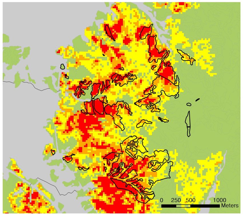
Forests 2021, 12, 545                                                                                            2 of 8

                        of gypsy moth outbreaks to nitrogen concentrations in stream water in the Fifteenmile
                        Creek watershed [9].
                              Gypsy moth is native to Europe and Asia [10]. In North America, gypsy moth was
                        introduced from Europe in the 1860s, and is considered a major forest pest and a significant
                        invasive species in North America [5]. In contrast, gypsy moth in Korea is the Asian
                        subspecies and is only an occasional pest [11,12], although local outbreaks were observed
                        in the 1990s and 2000s [13,14]. Until the 1990s, there was little information about the
                        outbreak of gypsy moth in Korea, except for a small outbreak in 1200 deciduous trees in
                        Seoul in 1959 [12]. Gypsy moth in Korea has a wide host range, including both deciduous
                        and coniferous trees, but the host preference of the moth has not been recorded [14]. The fact
                        that the egg masses of gypsy moth were collected in mainly Quercus spp. forests in the early
                        1990s suggest that Quercus spp. are potentially preferred hosts in Korea [12]. Similarly,
                        gypsy moth in North America prefers Quercus, Populus, and Salix spp., and outbreaks of
                        the moth usually occurred in these forests [10]. In Korea, gypsy moth outbreaks are more
                        commonly observed in forests near human residences than in natural forests [14].
                              The aim of this study was to quantify the extent and severity of gypsy moth defo-
                        liation in and around Wonju, Korea, in 2020 using Landsat Satellite Images and NDMI,
                        documenting the extensive outbreak of gypsy moth reported there by Jung et al. [15].
                        By analyzing defoliated areas, we determined the pest’s field host preference and the
                        physical characteristics of the areas defoliated by gypsy moth in Korea.

                        2. Materials and Methods
                        2.1. Study Site
                             The forest area examined was located in Wonju, Gangwon-do, Korea (37◦ 210 500 N,
                        127◦ 560 4300
                                   E). Wonju is an urban area with 350,000 residents and an area of 867.30 km2 .
                        The climate at the survey area is continental, with an annual mean temperature of 12.3 ◦ C
                        and an annual precipitation of 1276 mm over the last decade (Korean Meteorological
                        Administration, http://www.weather.go.kr (accessed on 26 April 2021)).

                        2.2. Satellite Image Acquisition and Analysis
                              To assess the area of forest damaged by gypsy moth, serial Landsat images (Path/Row
                        115/34) covering Wonju and the surrounding area from 2017 to 2020 were obtained from
                        the USGS EarthExplorer homepage (https://earthexplorer.usgs.gov (accessed on 26 April
                        2021)). Basically, one scene of Landsat covered Wonji city and its vicinity. To estimate base-
                        line information for each year, 20 images per year were collected. Therefore, 60 images were
                        collected to estimate 3 prior years baseline information. The Landsat-8 images used in this
                        study were orthorectified, radiometrically corrected, and included a cloud mask. Landsat
                        images from 2017 to 2019 were used to produce baseline information before the event using
                        a pixel-based time-series gap filling method [16]. Additionally, images from 2020 were used
                        to evaluate the damage caused by the event compared to the past. Damaged forest areas
                        were evaluated based on the difference between the Normalized Difference Moisture Index
                        (NDMI) estimated from images acquired in 8 June 2020, and the mean NDMI estimated
                        from images acquired in June from 2017 to 2019. NDMI is an effective index to evaluate
                        the extent of forest damage from natural or anthropogenic disturbances [3]. The values
                        of NDMI ranged from −1 to 1, with values closer to 1 meaning higher canopy cover [17].
                        The mean NDMI value from 2017 to 2019 (pre-defoliation) was calculated by the methods
                        proposed by Kim et al. [16], such as NDMI = (NIR−SWIR1)/(NIR + SWIR1), where NIR is
                        the pixel value from the near infrared band (0.85–0.88 µm) and SWIR1 is the pixel value
                        from the short-wave infrared 1 band (1.57–1.65 µm) [18]. A mean NDMI map from 2017
                        to 2019 was produced by the time-series gap-filling method using clear sky pixels [16].
                        This map provided baseline information before the event.
                              Through the visual inspection of satellite images for Wonju in June 2020, forest areas
                        with a red or brown color were selected, and those areas where the NDMI value had
                        decreased by 0.2 compared to the values from 2017 to 2019 were noted. To minimize
Forests 2021, 12, 545 3 of 8
errors during the imaging process, areas where the NDMI was reduced by over 0.05 were
considered to be defoliated by gypsy moth. The degree of forest defoliation was classified
into three levels: (1) Severe (NDMI reduction of ≥0.2), (2) moderate (NDMI reduction
of >0.125 to 0.2) or (3) light (NDMI reduction of 0.05 to 0.125). The forest types used for
the classification of stands were based on a forest type map (http://www.forest.go.kr
(accessed on 26 April 2021)). The Korean forest type map was produced with 5-year
intervals using aerial photography and field observations at two spatial scales: 1:5000 and
1:25,000 [19]. In our analysis, a 1:5000 scale map was used. Forests with >75% coniferous
trees or >75% deciduous trees were classified as coniferous or deciduous. Coniferous
stands were further divided into Korean red pine (Pinus densiflora Siebold & Zucc.), Korean
white pine (P. koraiensis Siebold & Zucc.), Japanese larch (Larix kaempferi (Lamb.) Carrière),
and other forests. The deciduous stands were divided into oak (Quercus spp.) forests
and other forests. Areas with >25% butForests 2021, 12, 545 4 of 8
Figure 1. Comparison between field survey results and Landsat-based gypsy moth defoliation maps in the center of Wonju.
Damage degree represents the mean reduction in Normalized Difference Moisture Index (NDMI) scores calculated using all
the available observations in June from 2017 to 2019. The closed curves indicated the larch stands defoliated by gypsy moth
observed through a field survey.
3. Results
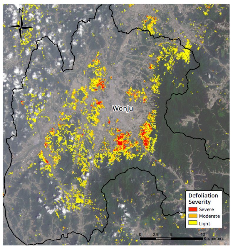
For the total forested area (60,186 ha) in Wonju, the NDMI values of 7825 ha were
reduced more than 0.05 (our criterion for at least light defoliation) when compared to
the location mean NDMI values for the prior 3 years (2017 to 2019), suggesting that this
area had been affected by gypsy moth defoliation (Figure 2, Table 1). The estimates of areas
with moderate and heavy defoliation were 1350 and 656 ha, respectively. At least 13.0% of
the forest area in Wonju was at least partially defoliated by gypsy moth.
The field survey results showed that eighteen stands were defoliated by gypsy moth
and all of them were L. kaempferi stands (Figure 1). Among them, 93.0% of stands were
judged as defoliated stands by our satellite image analysis, with severe defoliation at 37.4%,
moderate defoliation at 30.6%, and light defoliation at 25.0%. In addition to the larch stands,
extensive defoliation by gypsy moth was observed (Figure 2). These results suggested that
the Landsat satellite image analysis using NDMI is a useful method to detect the extent
and severity of defoliation caused by forest pests in Korea.
The host preferences of gypsy moth based on the satellite image analysis showed that
the occurrence of gypsy moth concentrated on the specific forest type (χ2 = 759.3, df = 6,
p < 0.01). The preference indexes of gypsy moth ranged from 36.1 to 100 according to the
forest stand type and was the highest for the larch stand. The preference for P. koraiensis
was lowest and the preference for Quercus spp. was 37.6.Forests 2021, 12, 545 5 of 8
Figure 2. Landsat-based gypsy moth defoliation maps in Wonju and the surrounding area in 2020.
Mapped results represent the mean reduction in Normalized Difference Moisture Index (NDMI)
scores calculated using all the available observations in June from 2017 to 2019.
Table 1. Area defoliated by gypsy moth at Wonju in 2020 according to the defoliation severity and forest type. The areas
were estimated based on the reduction in NDMI in 2020 compared to the prior 3 years.
Forest Type
Defoliation
Pinus Pinus Larix Other Quercus Other Total
Severity Mixed
densiflora koraiensis kaempferi Coniferous Spp. Deciduous
27 14 274 24 82 178 57 656
Severe
(0.3%) (0.5%) (5.2%) (2.2%) (0.4%) (1.1%) (0.7%) (1.1%)
119 44 301 47 235 404 198 1350
Moderate
(1.5%) (1.6%) (5.7%) (4.4%) (1.2%) (2.5%) (2.6%) (2.2%)
788 184 626 108 1457 1573 1084 5820
Light
(10.1%) (6.7%) (11.8%) (10.1%) (7.6%) (9.7%) (14.0%) (9.7%)
6843 2491 4105 894 17,511 14,139 6378 52,361
None
(88.0%) (91.1%) (77.4%) (83.3%) (90.8%) (86.8%) (82.6%) (87.0%)
Total 7777 2734 5306 1073 19,285 16,294 7717 60,186
4. Discussion
Remote sensing, including satellite images, has been extensively used in Canada and
the USA to quantify and map outbreaks of forest pests [3,5]. In Korea, remote sensing
studies have been carried out mainly for oligophagous forest pests, such as pine wilt diseaseForests 2021, 12, 545 6 of 8
and Korean Oak wilt [22,23]. Our study shows that remote sensing images, with the use
of an appropriate index, are also useful for detecting the damage of polyphagous forest
pests. Moreover, unexpected outbreaks of new or occasional forest pests are increasing
due to climate change and invasions of exotic pests. Under these circumstances, remote
sensing using satellite images is useful for detecting or monitoring outbreaks of forest
pests that cause widespread defoliation. For example, in Sweden, the invasive scale insect
Physokermes inopinatus was effectively monitored using satellite images [4].
Outbreaks of gypsy moths have been extensively studied in North America since
gypsy moth is one of the most serious forest pests in the region, where it has a long
history of spreading and attempted control [10]. After the first occurrence of gypsy moth
in the 1860s, it dispersed eastward and south. An entomophagous fungus, Entomophaga
maimaiga, is considered one of key natural enemies currently regulating its population [15].
In southern New England, a wide outbreak of gypsy moth was observed from 2015 to 2017,
following a 30-year period without significant outbreaks. The recent outbreak was due to
reduced levels of larval mortality from the fungus due to a series of dry springs from 2014
and 2016 [3]. In addition, higher winter temperatures may have increased the survival of
gypsy moth eggs [24].
Interestingly, the 5.2% of the stands of Japanese larch severely damaged by gypsy moth
in Korea was greater than the amount damaged for other stand types (e.g., oak at 0.4%)
(Table 1). Among forests defoliated by gypsy moth, the area of Japanese larch stands was
the highest (22.7% of the total of the larch stand) (Table 1). The preference index was also
highest for the larch forests. The results of the field survey also showed that Japanese larch
was the most heavily attacked tree species. Although deciduous stands were not identified
at the species level by forest type maps or satellite images, our results showed that oak
forests are less heavily defoliated than other deciduous forests, suggesting that Quercus
spp. were not the most preferred species among deciduous species (Table 1). Previous field
surveys in Wonju showed that Euonymus alatus, L. kaempferi, P. rigida, Populus davidiana, Q.
serrata, Prunus sargentii, and a shrub, Rhododendron schlippenbachii, were severely defoliated
tree species, while oaks such as Q. acutissima, Q. aliena, Q. mongolica, and Q. palustris
were only moderately defoliated [15]. These results contradicted with previous studies
showing that Quercus spp. are some of the most preferred hosts for gypsy moth [10,12].
Further studies on host preferences are necessary to clarify the host preference of Korean
gypsy moth.
Our analysis showed that defoliated areas were mainly concentrated near urban areas
rather than more remote mountain areas. This was also observed in Chungju, Jecheon,
and Hoengseong, in the vicinity of Wonju (Figure 1). This phenomenon was similar to
earlier outbreaks of gypsy moth in Korea that were observed primarily in or near urban
areas [14]. It has been hypothesized that the natural enemy regulation of gypsy moth may
be weaker in or near urban areas compared to more remote forests in mountains. In the case
of Lymantria mathura, a species similar to L. dispar, many natural enemies such as the para-
sitoid Cotesia melanosceifus (Ratzeburg) and several entomophagous pathogens stabilized
the density of L. mathura in Korea [25]. The activities of these natural enemies probably
decreased due to dryness or disturbance in or near urban forests. The second possible
explanation for the spatial pattern of gypsy moth defoliation is that urban environments
offer more opportunity for increase in gypsy moth populations. The lights from urban
areas attract adult moths, which may then lay their eggs locally. Moreover, the winter
temperatures near urban areas can be higher than those in forested areas, and this may
increase the winter survival of gypsy moth eggs.
5. Conclusions
Our study showed that areas defoliated by gypsy moth may be effectively detected us-
ing satellite images and that such information may help us understand the characteristics of
outbreaks of gypsy moths. Gypsy moth populations in Wonju severely defoliated Japanese
larch trees at higher rates than other tree species or groups. Additionally, gypsy mothForests 2021, 12, 545 7 of 8
damage was concentrated in or near urban areas. Our results showed that remote sensing
methods are useful for detecting or monitoring damage caused by some forest pests, such as
those that occasionally reach outbreak densities or that are newly invasive species. More-
over, the defoliation maps estimated by remote sensing techniques can be basic information
for outbreak risk analysis using numerical and mathematical methods [26–30].
Author Contributions: Conceptualization, W.-I.C., E.-S.K., and J.-H.L.; methodology, E.-S.K.; valida-
tion, W.-I.C., E.-S.K., and J.-H.L.; formal analysis, W.-I.C. and E.-S.K.; data curation, E.-S.K., S.-J.Y.,
and Y.-E.K.; writing—original draft preparation, W.-I.C. and E.-S.K.; writing—review and editing,
W.-I.C. and E.-S.K.; visualization, S.-J.Y. and Y.-E.K. All authors have read and agreed to the published
version of the manuscript.
Funding: This research received no external funding.
Conflicts of Interest: The authors declare no conflict of interest. The funders had no role in the design
of the study; in the collection, analysis, or interpretation of data; in the writing of the manuscript;
or in the decision to publish the results.
References
1. Pasquarella, V.J.; Bradley, B.A.; Woodcock, C.E. Near-Real-Time Monitoring of Insect Defoliation Using Landsat Time Series.
Forests 2017, 8, 275. [CrossRef]
2. Housman, I.W.; Chastain, R.A.; Finco, M.V. An evaluation of forest health insect and disease survey data and satellite-based
remote sensing forest change detection methods: Case studies in the United States. Remote Sens. 2018, 10, 1184. [CrossRef]
3. Hall, R.J.; Castilla, G.; White, J.C.; Cooke, B.J.; Skakun, R.S. Remote sensing of forest pest damage: A review and lessons learned
from a Canadian perspective. Can. Entomol. 2016, 148, S296–S356. [CrossRef]
4. Olsson, P.-O.; Jönsson, A.M.; Eklundh, L. A new invasive insect in Sweden—Physokermes inopinatus: Tracing forest damage with
satellite based remote sensing. For. Ecol. Manag. 2012, 285, 29–37. [CrossRef]
5. Pasquarella, V.A.; Elkinton, J.S.; Bradley, B.A. Extensive gypsy moth defoliation in Southern New England characterized using
Landsat satellite observations. Biol. Invasions 2018, 20, 3047–3053. [CrossRef]
6. Rahimzadeh-Bajgiran, P.; Weiskittel, A.R.; Kneeshaw, D.; MacLean, D.A. Detection of Annual spruce budworm defoliation and
severity classification using Landsat imagery. Forests 2018, 9, 357. [CrossRef]
7. Spruce, J.P.; Sader, S.; Ryan, R.E.; Smoot, J.; Kuper, P.; Ross, K.; Prados, D.; Russell, J.; Gasser, G.; McKellip, R.; et al. Assessment of
MODIS NDVI time series data products for detecting forest defoliation by gypsy moth outbreaks. Remote Sens. Environ. 2011,
115, 427–437. [CrossRef]
8. Zhang, J.; Huang, Y.; Pu, R.; Gonzalez-Moreno, P.; Yuan, L.; Wu, K.; Huang, W. Monitoring plant diseases and pests through
remote sensing technology: A review. Comput. Electron. Agric. 2019, 165, 104943. [CrossRef]
9. Townsend, P.A.; Eshleman, K.N.; Welcker, C. Remote sensing of gypsy moth defoliation to assess variations in stream nitrogen
concentrations. Ecol. Appl. 2004, 14, 504–516. [CrossRef]
10. Elkinton, J.S.; Liebhold, A.M. Population dynamics of gypsy moth in North America. Ann. Rev. Entomol. 1990, 35, 571–596.
[CrossRef]
11. Lyu, D.; Lee, D.W. Occurrence of Gypsy Moth, Lymantria dispar around pier in Korea and comparison of insecticide response
depending on instar. Korean J. Pestic. Sci. 2019, 23, 1–7. [CrossRef]
12. Pemberton, R.W.; Lee, J.H.; Reed, D.K.; Carlson, R.W.; Han, H.Y. Natural Enemies of the Asian Gypsy Moth (Lepidoptera:
Lymantridae) in South Korea. Ann. Entomol. Soc. Am. 1993, 86, 423–440. [CrossRef]
13. Lee, H.-P.; Lee, H.-M. Seasonal occurrence and monitoring of gypsy moth, Lymantria dispar L. (Lepidoptera: Lymantriidae) by sex
pheromone trap in Mt. Namsan, Seoul. Korean J. Ecol. 1999, 22, 299–303.
14. Shin, S.C.; Choi, K.S.; Choi, W.I.; Chung, Y.J.; Lee, S.G.; Kim, C.S. An New Illustrated Book of Forest Insect Pests; Upgo MunHwa:
Seoul, Korea, 2008.
15. Jung, J.-K.; Nam, Y.W.; Kim, D.S.; Lee, S.H.; Lim, J.H.; Choi, W.I.; Kim, E.S. Tree-crown defoliation caused by outbreak of forest
insect pests in Korea during 2020. Korean J. Appl. Entomol. 2020, 59, 409–410.
16. Kim, E.-S.; Lee, B.; Lim, J.-H. Forest damage detection using daily normal vegetation index based on time series Landsat Images.
Korean J. Remote Sens. 2019, 35, 1133–1148.
17. Lastovicka, J.; Svec, P.; Paluba, D.; Kobliuk, N.; Svoboda, J.; Hladky, R.; Stych, P. Sentinel-2 Data in an Evaluation of the Impact of
the Disturbances on Forest Vegetation. Remote Sens. 2020, 12, 1914. [CrossRef]
18. USGS. Landsat Surface Reflectance-Derived Spectral Indices-Normalized Difference Moisture Index. 2020. Available online:
https://www.usgs.gov/core-science-systems/nli/landsat/normalized-difference-moisture-index (accessed on 26 April 2021).
19. Kang, Y.; Jang, E.; Im, J.; Kwon, C.; Kim, S. Developing a New Hourly Forest Fire Risk Index Based on Catboost in South Korea.
Appl. Sci. 2020, 10, 8213. [CrossRef]
20. Chesson, J. Measuring preference in selective predation. Ecology 1978, 59, 211–215. [CrossRef]Forests 2021, 12, 545 8 of 8
21. Richardson, J. Analysis of Field and Laboratory Foraging ‘Selectapref’ R Package Version. 2017. Available online: https:
//CRAN.R-pro-ject.org/package=selectapref (accessed on 26 April 2021).
22. Cha, S.; Lee, W.-K.; Kim, M.; Lee, S.-G.; Jo, H.-W.; Choi, W.I. Characterization the spatial distribution of oak wilt disease using
remote sensing data. J. Korean For. Soc. 2017, 106, 310–319.
23. Kim, S.-R.; Kim, E.-S.; Nam, Y.W.; Choi, W.I.; Kim, C.-M. Distribution characteristics analysis of pine wilt disease using time series
hyperspectral aerial imagery. Korean J. Remote Sens. 2015, 31, 385–394. [CrossRef]
24. Smitley, D.; Andresen, J.; Priest, R.; Mech, R.; Mccullough, D. Winter mortality of gypsy moth (Lepidoptera: Lymantriidae) eggs
in Michigan. Environ. Entomol. 1998, 3, 700–708. [CrossRef]
25. Lee, J.-H.; Lee, H.-P. Parasites and phenology of Lymantria mathura Moore (Lymantriidae: Lepidoptera) in Kyonggi Province,
Korea. Korean J. Entomol. 1996, 26, 393–401.
26. Nam, Y.; Koh, S.-H.; Jeon, S.-J.; Youn, H.-J.; Park, Y.-S.; Choi, W.I. Hazard rating of coastal pine forests for a black pine bast scale
using self-organizing map (SOM) and random forest approaches. Ecol. Inform. 2015, 29, 206–213. [CrossRef]
27. Dargahi, M.; Newson, T.; Moore, J.R. A Numerical Approach to Estimate Natural Frequency of Trees with Variable Properties.
Forests 2020, 11, 915. [CrossRef]
28. Kayet, N.; Chakrabarty, A.; Pathak, K.; Sahoo, S.; Dutta, T.; Hatai, B.K. Comparative analysis of multi-criteria probabilistic FR and
AHP models for forest fire risk (FFR) mapping in Melghat Tiger Reserve (MTR) forest. J. For. Res. 2020, 31, 565–579. [CrossRef]
29. He, S.; Lin, L.; Wu, Z.; Chen, Z. Application of Finite Element Analysis in Properties Test of Finger-jointed Lumber. J. Bioresour.
Bioprod. 2020, 5, 124–133. [CrossRef]
30. Ibitoye, S.E.; Adegun, I.K.; Omoniyi, P.O.; Ogedengbe, T.S.; Alabi, O.O. Numerical investigation of thermo-physical properties of
non-newtonian fliud in a modelled intestine. J. Bioresour. Bioprod. 2020, 5, 211–221. [CrossRef]You can also read