Manningham Bus Network Review 2017 - Manningham Council
←
→
Page content transcription
If your browser does not render page correctly, please read the page content below
Manningham Bus Network Review 2017 |Page0
CONTENTS
                                                                                              Page
                                                                                             Number

Executive Summary                                                                              2
1. Introduction                                                                                3
2. Overview of the Manningham Bus Network                                                      5
         Responsible Authority for Infrastructure and Services                                 6
         Manningham Bus Service Characteristics                                                8
         Summary of Bus Services Operating in Manningham                                       9
         Network Service Gaps                                                                  15
         Busiest Bus Stops in Manningham                                                       15
         Busiest Bus Corridors in Manningham                                                   17
         Characteristics of Bus Corridors Outside of Manningham                                19
         Pedestrian Access to Bus Stops                                                        20
         Myki                                                                                  21
3. Other Relevant Bus Network Reviews                                                          22
4. Influences and Observations                                                                 24
5. Bus Rapid Transit (BRT)                                                                     31
6. Meandering Bus Routes                                                                       35
7. Provision of Bus Shelters                                                                   36
8. Recommendations                                                                             38
Appendix A – City of Manningham’s Bus Network Map                                              40
Appendix B – Manningham Bus Services Patronage Data                                            41
Appendix C – Top 25 Most Patronised Metropolitan Bus Routes                                    42
Appendix D – Map of Busiest Bus Stops and Corridors in Manningham                              43
Appendix E – Map of New Bus Shelters and Preferred Bus Priority Improvements                   44

                Author: Frank Vassilacos (Senior Strategic Land Use and Transport Planner)

                Review: Final

                Endorsement Date: 31 October 2017 (Manningham City Council)

                Authorised by: Leigh Harrison, Director Assets and Engineering

Manningham Bus Network Review 2017                                                           |Page1
EXECUTIVE SUMMARY
A review of the Manningham bus network and services has been undertaken in order to identify
what improvements can be made to enhance the bus system – in how it operates to, from and
within Manningham.
The Manningham Bus Network Review 2017 has been prepared to assist Council to advocate to
State Government and other relevant authorities on bus related matters. The document
highlights gaps within the existing bus network, opportunities for better service provision and
connections and any necessary infrastructure improvements required to support priority for
buses on the road network.
This review seeks to identify and recommend suitable solutions and suggestions to improve the
overall bus network, particularly frequency and reliability, with the outcome of this review
providing 20 recommendations. The key findings of this Review identify:
A considerable growth in patronage levels over five years on all four DART SmartBus
services – which increased by 51% on weekdays, 79% on Saturdays and 72% on Sundays;
Notable weekend patronage growth (over 5 years) of DART route 907 (City to Mitcham
via Doncaster Road) of 150% on Saturdays and 194% on Sundays;
Considerable overcrowding on all DART buses during the peak, with many services
regularly leaving passengers behind;
A lack of bus priority and impact of growing traffic congestion through Doncaster Hill
and along Porter Street and parts of Blackburn, Thompsons and Manningham Roads;
Growing support for a Bus Rapid Transit (BRT) solution for CBD-bound travel;
The busiest bus stops in Manningham being the three main interchanges at Westfield
Doncaster, The Pines Shopping Centre and Doncaster Park & Ride;
Many of the busiest bus stops and bus corridors in Manningham are concentrated along
Doncaster Road, Doncaster Hill and Blackburn Road;
Population of Doncaster Hill is expected to more than quadruple over the next 20 years
from 2,370 people in 2016 to 11,187 by 2036;
Buses accommodate over one-third of all people who move along Hoddle Street – which
now serves as the busiest bus corridor in Melbourne with over 925 daily bus trips;
A general lack in police enforcement of bus lanes, compromising bus service efficiency;
A lack of regular bus services in many parts of Bulleen and Templestowe Lower and
areas east of the Mullum Mullum Creek (particularly on weekends);
A lack of sufficient bus connections between part of Manningham and employment,
health and tertiary education facilities in Heidelberg, Box Hill and Ringwood; and
General safety and congestion issues around the Warrandyte Bridge bus terminus.
Manningham Bus Network Review 2017 |Page2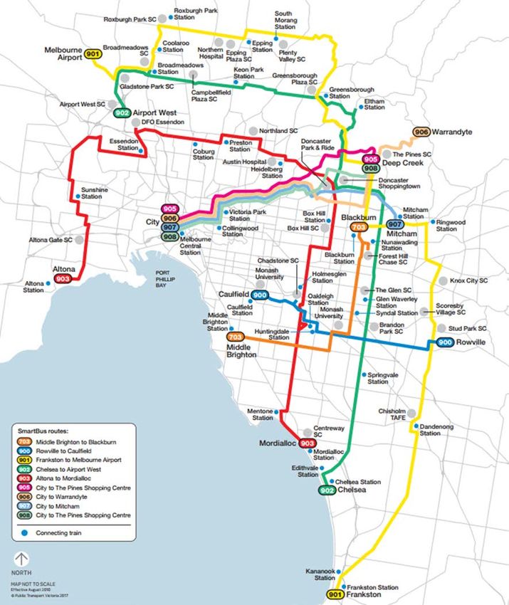
1. INTRODUCTION
The City of Manningham is the only municipality in metropolitan Melbourne to rely solely on
buses for its public transport services, as the area is not serviced by either light or heavy rail.
With a lack of fixed rail services and an over-reliance on the private motor vehicle, emphasis
must be placed on ensuring that the existing bus network operates effectively and efficiently to
provide a reliable alternative to the motor vehicle.
The Manningham Bus Network Review 2017 (the “Review”) provides an overview of the bus
network in both Manningham and beyond the municipality, by assessing the existing level of
service (routes, destinations and hours of operation), patronage figures, historic investment in
infrastructure and services, commuter amenity (shelter, safety and pedestrian access) and the
nature of existing priority for buses on the road network. The Review also explores what
contributes to current bus operations and any elements that have either enabled or hindered
growth in passenger patronage and/or service levels over the past five years.
The purpose of this review is to identify necessary service and infrastructure improvements,
centred on the following key objectives, to:
improve overall frequency and reliability and prioritise buses on the road network;
provide for a Bus Rapid Transit (BRT) solution between the CBD and Manningham to
meet continually growing demand;
simplify the bus network (with more direct and less meandering routes);
expand the frequency and hours of operation of bus services (into the evenings and
weekends);
provide for an improved standard of service to all parts of Manningham; including better
connections to neighbouring major activity areas, like train stations, hospitals and
tertiary education / university facilities in areas such as Box Hill, Heidelberg, Ringwood
and Kew;
identify strategic locations for new bus shelters and improved passenger facilities; and
identify traffic pinch-points and where to consider bus priority measures (i.e. bus lanes
and intersection traffic-signal enhancements).
As it is contained within the Manningham Integrated Transport Strategy (2009), it is Council’s
objective – to achieve an improvement in overall transport access and connectivity within and
between the municipality and key destinations throughout metropolitan Melbourne in order to
encourage a continued uptake of public transport use by the community. Adequate access to
reasonable public transport services seeks to achieve social equity for our community and
promote Plan Melbourne’s concept of the ‘20 Minute Neighbourhood’ to efficiently connect
people to jobs, social services, education and recreational activities – within a 20 minute journey
of their homes by public transport, walking and/or cycling.
Manningham Bus Network Review 2017 |Page3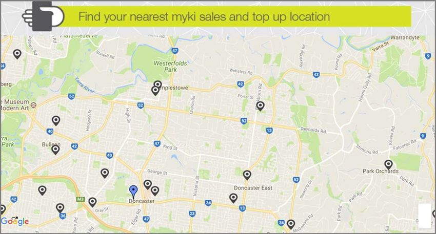
In 2016, Infrastructure Victoria released its ‘30-Year Infrastructure Strategy’, which outlined
recommendations for the Victorian State Government to consider. A key theme of many
transport-related recommendations centred on the objective to focus future investment in
maximising and expanding on existing assets and infrastructure. A primary focus of Infrastructure
Victoria’s Strategy provides for recommendations to invest more greatly in the bus network
through various initiatives, namely:
Doncaster bus improvement (recommending a BRT)
Utilising existing assets
Reallocation of road space (to public transport)
Hoddle Street/Punt Road public transport prioritisation
Metropolitan bus network reform
SmartBus service provision increase
Strategic transit-oriented development
North-East Link
This review has been undertaken in consultation with Transdev (the company responsible for the
operation of the majority of bus services in Manningham), Panorama Coaches (which operates
two bus services to Warrandyte) and Ventura (which operates a service to Wonga Park).
Consideration has also been given to any objectives or proposals that have been previously
suggested or raised with, or by, government authorities, including Public Transport Victoria
(PTV), VicRoads and the newly established Transport for Victoria.
Manningham Bus Network Review 2017 |Page4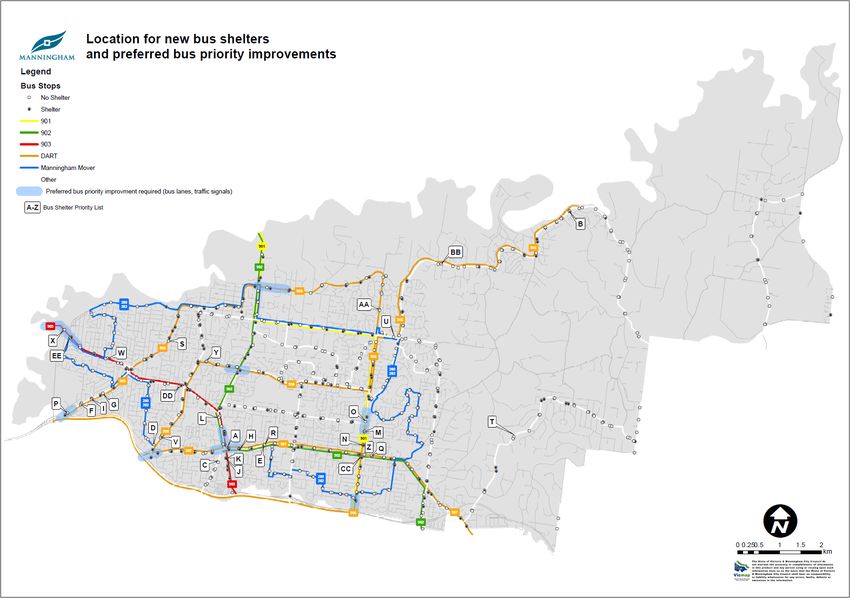
2. OVERVIEW OF
             MANNINGHAM’S BUS
                 NETWORK
A total of 27 bus routes operate to, from and within the City of Manningham, including seven (7)
SmartBus routes (4 radial and 3 orbital), 17 regular local services, two (2) peak-only services and
the Manningham Mover ‘loop’ service. In addition, two (2) NightRider services are provided from
the CBD to Doncaster and Lilydale that service the Manningham area during the late-
evening/early morning on weekends.

With no fixed rail or tram services provided within the City of Manningham, its 121,000 residents
rely solely on buses to meet their public transportation needs within the boundaries of the
municipality. This has likely contributed to a higher than average car ownership rate per
household (of 2 cars owned per household in Manningham compared to 1.7 for the Greater
Melbourne area) with 62% of all dwellings owning two (2) or more vehicles (compared to 51% for
Greater Melbourne) [Australian Bureau of Statistics Census, 2016].

Figure 1 – Travel to Work Method (2011)

                                                                         As outlined in Figure 1 -
    0.3%
                                                                         according to the findings
  1.1%                                                                   of the 2011 Census, 68%
                                                    Car - Driver
                 17.5%                                                   of the City of
 3.3%                                               Car - Passenger
                                                                         Manningham’s working
                                                    Bus
                                                                         residents (36,052 people)
                                                    Train                travelled outside of the
         7.5%
                                                    Walk                 municipality to work,
                                          65.6%
                                                    Cycle                with 66% of employed
 4.7%                                               Other                Manningham residents
                                                                         travelling to work by
                                                                         private motor vehicle (as
                                                                         a driver) compared to the
 Source: Australian Bureau of Statistics, 2011.                          Greater Melbourne
                                                                         average of 60.5%.

Eleven per cent (11%) of all employed Manningham residents use public transport to travel to
work (compared to the Greater Melbourne average of 13.5%). Of these, 7.5% travel by bus,
which represents one of the highest proportions of this mode for a local government area in

Manningham Bus Network Review 2017                                                        |Page5
metropolitan Melbourne (when compared to 1.5% for Greater Melbourne). This clearly
illustrates the reliance on the bus for Manningham residents.

In recent years, there has been a growing emphasis on apartment living, urban consolidation and
densification, as well as due consideration for the impact of climate change and growing traffic
congestion. As such, demand for public transport use by (employed) Manningham residents has
steadily grown between 2006 and 2011 from 8.5 per cent to 10.9 per cent of journeys to work
being undertaken by public transport (bus, train or tram) [Australian Bureau of Statistics, 2011].

This growth can be attributed to a $350 million investment in 2009 in the Doncaster Area Rapid
Transit (DART) system, which sought to upgrade four (4) existing bus routes between the CBD
and Manningham to a SmartBus standard, vastly improving the frequency, reliability and
prominence of the bus on these routes.

However, there is a significant contrast between east and west Manningham (divided by the
Mullum Mullum Creek corridor), in relation to the extent and frequency of the bus network. The
bus services in the eastern portion of Manningham in Warrandyte, Park Orchards, Wonga Park
and Donvale are often sparse and infrequent when compared to the more urbanised areas in the
west (Bulleen, Doncaster areas and Templestowe areas).

Bus patronage across Metropolitan Melbourne has seen a considerable increase over the past 10
years, with patronage steadily growing at 4.5% per annum from 79.13 million trips in 2005 to
122.5 million trips in 2015 [PTV, 2016]. However, during the 2015/16 financial year, bus
patronage on the overall metropolitan bus network declined by 5.5 per cent to its lowest level in
four years [PTV, 2016]. This may be attributed to the lack of capacity on the existing bus fleet,
impact of traffic congestion on the reliability of bus services and potentially the impact of lower
fuel prices in recent years.

Responsible authorities for infrastructure and
services
Bus services

The majority of bus services in Manningham are privately operated by Transdev (24 routes), with
two (2) routes from Warrandyte to Eltham operated by Panorama Coaches and one (1) route
from Croydon to Wonga Park by Ventura.

Transdev also operates approximately one third of Melbourne’s bus network and is currently
contracted by the State Government to operate its bus services until August 2020, with an option
to extend the contract by three (3) years to August 2023.

Bus Stops

There are 640 bus stops located throughout the municipality. The installation of bus stops is
usually funded and approved by PTV and PTV usually manages issues or maintenance of major
bus stops on DART or SmartBus routes (main roads). The provision of shelters and seating is

Manningham Bus Network Review 2017                                                       |Page6
generally the responsibility of Council. Council is often responsible for maintaining bus stop
infrastructure and other ground assets, along with the footpath network connecting to bus stops.
Adshel is currently contracted by Council to maintain bus shelters throughout the municipality,
as Adshel also manage bus shelters that display commercial advertising. This contract is due for
renewal in early 2018.

Transport Planning, Responsibility and Funding

Department of Economic Development, Jobs, Transport and Resources (DEDJTR)

The State Department of Economic Development, Jobs, Transport and Resources (DEDJTR)
oversees transport regulatory policy and legislation and is engaged in the delivery of a number of
major transport projects, as part of the government's integrated strategies to improve public and
private transport, freight and ports efficiency and other major infrastructure in urban and rural
Victoria.

Transport for Victoria

Transport for Victoria (TfV) is a new State transport agency that is coordinating Victoria's growing
transport system and planning for its future. The new agency brings together the planning,
managing and coordinating of Victoria's transport system and its agencies. To achieve this, key
functions have been transferred from Public Transport Victoria (PTV) and VicRoads to Transport
for Victoria, including strategic and statutory planning, policy and legislation, budget strategy and
rolling stock procurement. Transport for Victoria’s role is to strategically plan for the future of
Victoria's transport system, ensuring it grows as the community, economy and technology
changes.

VicRoads

VicRoads is a State transport agency which plans, develops and manages the arterial road
network in order to provide a more integrated and sustainable road transport system. An
integral part of this objective is to provide a road network that caters for and supports buses and
other modes such as cycling. VicRoads has produced the SmartRoads Network Operating Plan
which seeks to prioritise trams and buses on key public transport routes that link activity centres.

Public Transport Victoria

Public Transport Victoria (PTV) is a statutory authority that acts as a system authority for all
public transport and an advocate for public transport users – primarily responsible for the
operation of public transport services. PTV is a single contact point for customers wanting
information on public transport services, fares, tickets and initiatives. PTV aims to improve public
transport in Victoria by ensuring better coordination between modes, facilitating expansions to
the network, auditing public transport assets and promoting public transport as an alternative to
the car.

Manningham Bus Network Review 2017                                                         |Page7
Plan Melbourne 2017-2050
Plan Melbourne seeks to guide the growth of the city for the next 35 years. It sets the strategy for
supporting jobs, housing and transport, while building on Melbourne's legacy of distinctiveness,
liveability and sustainability.
A key transport objective of Plan Melbourne is to ensure that Melbourne has an integrated
transport system that connects people to jobs and services and goods to market by investing in
the Principal Public Transport Network (PPTN). It seeks to achieve this by promoting the concept
of the ‘20-minute neighbourhood’ which aims to give Melbournians the ability to 'live locally'
through fostering most of their everyday needs within a 20-minute walk, cycle or local public
transport trip of their home. It also considers improving transport connections to identified
‘employment clusters’ including the La Trobe National Employment and Innovation Cluster of
which includes the Heidelberg activity centre.
Manningham City Council
In terms of transport, Manningham City Council is responsible for administering the local road
network, provision and maintenance of walking and cycling paths, managing parking matters and
some bus stop infrastructure. Council is also responsible for promoting and advocating for
transport matters on behalf of its local community, as outlined in many of its transport-related
strategies and policies including the Manningham Integrated Transport Strategy 2009, the
Manningham Link Roads Improvement Strategy 2014, Bicycle Strategy 2013 and the Walk
Manningham Plan 2011-2020.
Although Council is not directly responsible for funding or managing the public transport system
or arterial road network, it plays a pivotal role in ensuring that any State-initiated projects or
proposals are considered or delivered in a manner that provides maximum benefit and minimal
disruption or disadvantage to the local community.
Manningham Bus Service Characteristics
Bus services are generally characterised into three (3) distinct levels of service, with each level
serving a particular purpose in the wider public transport network. Table 1 below outlines these
three levels of bus services and their common characteristics:
Table 1 – Bus Service Characteristics
Route Broad Public Transport Objectives Services in Manningham
Category
Principal Routes are predominantly cross-town or orbital The seven (7) SmartBus
routes, which provide a level of service similar DART & Orbital routes
to trams or light rail.
• Together with tram and train routes, they form
the PPTN servicing Major and Metropolitan
Activity Centres.
Main Local Together with Principal routes account for the Majority of local
majority of remaining bus services. Manningham bus routes
Manningham Bus Network Review 2017 |Page8Route Broad Public Transport Objectives Services in Manningham
Category
Community Routes are often circuitous due to the existing Manningham Mover
Local street layout, and mainly serve a local area. (Route 280/2)
Some bus services are operated by an on-
demand ‘Telebus’ method, however no such
service exists within the City of Manningham.
Summary of Bus Services Operating in
Manningham
The following provides an overview of the variety of bus services offered in Manningham,
including an assessment of the current and historical patronage figures. A map of the bus
network servicing the Manningham local government area is contained in Appendix A.
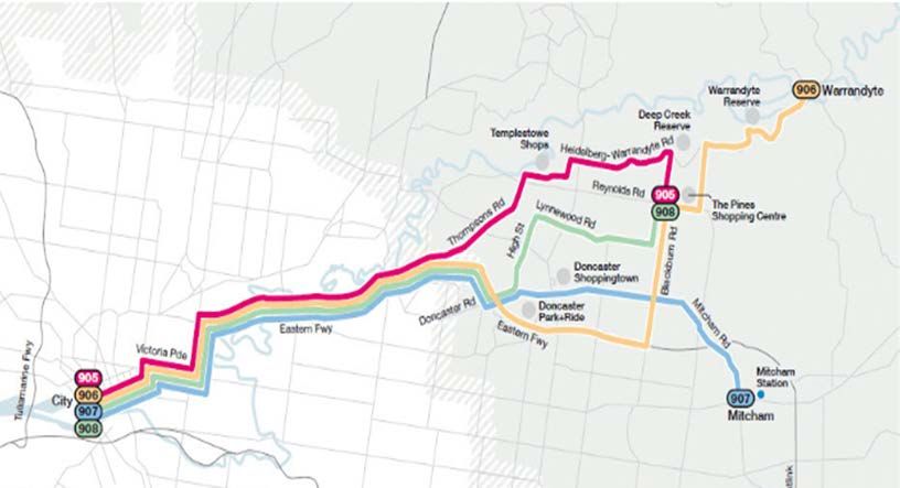
DART (Doncaster Area Rapid Transit) SmartBus
In October 2010, four (4) existing local bus services were upgraded to a SmartBus standard in
order to provide regular and frequent services between Manningham and the CBD. These routes
are illustrated in Figure 2 below. It should be noted that all four routes were already existing
services that operated along a similar route (formally operated as routes 301, 304, 307 and 319).
In the first nine months of operation, DART bus patronage increased more than 30 per cent to
10,700 passengers each weekday (PTV, 2012).
Figure 2 – The Doncaster Area Rapid Transit (DART) Network
The frequency of DART services generally ranges between 5 to 10 minutes in the morning and
evening peak period, 15 minutes during the rest of the day until 9.00 pm, then 30 minutes to
midnight. Between 70 and 78 daily one-way services are provided by each of the four routes on
an average weekday. Weekend services on routes 905 and 906 operate every 30 minutes, and
on routes 907 and 908, every 20 minutes.
Manningham Bus Network Review 2017 |Page9DART and SmartBus are successful examples that demonstrate the attractiveness of the bus
network to commuters when an investment has been made to provide for bus services that are
frequent, direct and prominent in nature (branding), given that all four DART services operated
as regular bus routes prior to being upgraded. Furthermore, six of the nine SmartBus services
throughout Manningham account for the top six most patronised bus services throughout all of
metropolitan Melbourne.
As illustrated in Table 2, the number of people using the DART system approaches similar
patronage experienced on the Upfield (train) Line (Infrastructure Victoria, 2016), with patronage
of the DART network increasing by 51% on weekdays, 79% on Saturdays and 72% on Sundays in
the five (5) years since DART was first introduced in October 2010. These four services
collectively carried 16,000 passengers on an average weekday in 2015/16 (up from 10,500 in
2010/11) with DART routes 907, 906 and 905 accounting for the 6th, 11th and 19th most
patronised bus routes in all of Melbourne (respectively).
Table 2: DART SmartBus Patronage (2015/16) and Growth over 5 years (Oct 2010/11 to
2015/16)
Growth in weekly Average Average Average
Route Service patronage weekday Saturday Sunday
(2010/11- patronage patronage patronage
2015/16) (2015/16) (2015/16) (2015/16)
905 City – The Pines (via 36 % 3,416 1,297 869
Thompsons Rd) (+36 %) (+44 %) (+24 %)
906 City – Warrandyte 59 % 4,410 1,802 1,189
(via Blackburn Rd) (+57 %) (+80 %) (+70 %)
907 City – Mitcham 78 % 5,717 3,007 2,060
(via Doncaster Rd) (+68 %) (+150 %) (+194 %)
908 City – The Pines (via 27 % 2,382 534 369
King St) (+32 %) (-11 %) (-26 %)
TOTAL: Avg: 54 % 15,925 6,640 4,487
(+51 %) (+79 %) (+72 %)
Source: Public Transport Victoria (Myki Data), 2016
NOTE: DART commenced operations in October 2010.
There has been notable growth in patronage on route 907 (that operates along the Doncaster
Road corridor to Mitcham via Doncaster Hill), with over 1.66 million patrons per annum in
2015/16.
Overall, there was a 78% growth in weekly patronage on this route, over almost five (5) years
since the route was introduced (in October 2010), with considerable growth recorded on
Saturdays (up 150%) and Sundays (up 194%). The growth in DART patronage is illustrated in
Figure 3. These figures confirm the observations and response from commuters regarding issues
with buses being overcrowded and leaving passengers behind during peak times due to a lack of
capacity on the current bus fleet.
All four DART services experienced considerable growth in the five years since introduction, with
the exception of weekend patronage on the 908 service, which declined by 11% and 26%
respectively on Saturdays and Sundays. However, this decline is likely attributed to changes to
Manningham Bus Network Review 2017 | P a g e 10the timetable implemented in 2015, as route 908 ceases to travel to the CBD on weekends and
now only operates between The Pines Shopping Centre and the CBD during the peak periods.
This service during the weekday off-peak period only operates between The Pines Shopping
Centre and Doncaster Park & Ride – passengers are required to transfer to another bus service to
access the CBD.
Figure 3: DART Weekly Patronage Growth: 2010/11 to 2015/16 (over 5 years)
18,000
15,925
16,000
14,000
NUMBER OF PASSENGERS
12,000
10,500
10,000
8,000 6,640
6,000
4,487
3,700
4,000 2,600
2,000
0
Weekday Saturday Sunday
2010/11 2015/16
Source: Public Transport Victoria, 2016
The overall growth in DART patronage can be attributed to various improvements and
investments in recent years, such as improved priority on the road network through the
provision of dedicated bus lanes on major roads, priority signalling operated at major
intersections, higher-capacity buses, a new Kiss & Ride facility in Bulleen and the initial
promotion of DART as a premium bus service (SmartBus branding). As part of the introduction of
SmartBus, all bus stops serviced by DART were upgraded to meet the requirements of the
Disability Discrimination Act 1992. By 2022, it is policy that all bus stops in Metropolitan
Melbourne meet the Disability Standards for Accessible Public Transport, 2002.
Transdev expects DART patronage to continue to grow at a rate of 7% per year, from 4.2 million
trips in 2017 to 6.4 million trips in 2046, as illustrated in Figure 4.
Figure 4: DART Annual Patronage Growth Forecast 2017 to 2046
8
Annual Passengers
6
6.4
(millions)
5.2 5.6
4 4.9
4.2 4.5
2
0
2017 2022 2027 2032 2037 2046
Manningham Bus Network Review 2017 | P a g e 11
Source: Transdev Australasia, 2017SmartBus Orbital
All three (3) SmartBus orbital routes service the Manningham area, providing frequent
connections to wider metropolitan Melbourne and link major employment centres, tertiary
institutions and activity centres. These services operate at similar frequencies to DART and all
three services perform as the top three most patronised bus routes in Melbourne. The route
characteristics of these three services are outlined in Table 3 below.
Table 3: Orbital SmartBus Patronage (2011/12 to 2015/16) and Route Characteristics
Route Service Four-year Total Percentage of the route
change in Route operating through Manningham
annual Distance
Patronage
901 Frankston to -10 % 110 km 9%
(Yellow) Melbourne Airport (Blackburn & Reynolds Roads)
902 Chelsea to Airport -8 % 75 km 15 %
(Green) West (Williamsons & Doncaster Rds)
903 Mordialloc to Altona -22 % 84 km 8%
(Red) (Manningham and Tram Roads)
These services experienced significant patronage growth in their first few years of operation
since 2006, due to considerable investment in regular bus services, dedicated bus lanes, priority
signalling and state-of-the-art GPS satellite tracking systems providing customers with real-time
information at most major stops. However, in the four years between 2011/12 and 2015/16,
annual patronage on all three routes declined, led by a 22% decline on route 903, a 10% decline
on route 901 and an 8% decline on route 902. The gradual change in patronage is further
illustrated in Figure 5.
Figure 5: SmartBus Orbital Annual Patronage 2011/12 to 2015/16
901 902 903
8
7 6.7
ANNUAL PASSENGERS (MILLIONS)
6
6
5.3
5 4.5 4.4
4.3 4.2
3.9 3.9
4
3
2
1
0
2011/12 2014/15 2015/16
Source: Public Transport Victoria, 2016
Manningham Bus Network Review 2017 | P a g e 12This decline may be attributed to the nature of these routes, as they each form some of the longest trips (by distance) in metropolitan Melbourne’s bus network, with one-way end-to-end trips taking between three and four hours to complete. These distances compromise reliability as buses can often be held up in traffic or other delays, affecting timetable reliability along the rest of the route. This compromise in reliability may contribute to commuters avoiding the service and opting for other travel options. Figure 6 illustrates the route map of the three SmartBus Orbital services (901, 902 and 903) along with all other SmartBus services throughout Metropolitan Melbourne. Figure 6 – The SmartBus and Orbital Network Image Source: PTV, 2015 Manningham Bus Network Review 2017 | P a g e 13
Local Services
There is a total of 19 local services that operate to and from Manningham, including two (2)
services that only operate during peak periods.

The primary destinations, including the CBD, Box Hill, Heidelberg, Kew and Westfield Doncaster,
generate the highest level of demand for local bus services. Demand is growing for more
frequent services to Box Hill to cater for a large multicultural and student population living in
Manningham and to Heidelberg for access to the railway station, Austin and Mercy Hospitals and
other community services in this area.

Local services experiencing the highest patronage growth over the four years between 2011/12
and 2015/16 in Manningham (in order of highest annual patronage) were Route 207 between
the City and Westfield Doncaster via Kew Junction (+ 86%), route 672 between Croydon Railway
Station and Chirnside Park via Wonga Park (+ 76%), Route 200 between the City and Bulleen
(+64%) and Route 305 between the City and The Pines via George Street (+ 49%).

Over the same four years, there was a considerable 70% decline in annual patronage on Route
295 from Box Hill to The Pines Shopping Centre and a 28% and 27% decline respectively on the
two routes that operate between Warrandyte and Eltham (Routes 578 and 579).

The table at Appendix B provides further data in relation to the level of patronage (based on
Myki ticket transactions/validations) for each local route in the four (4) years between 2011/12
and 2015/16.

Annual patronage data is also provided as Appendix C, which outlines the 25 busiest bus routes
in wider Metropolitan Melbourne in 2015/16. Eight of these 25 routes service the Manningham
area (highlighted in green).

Manningham Mover
The Manningham Mover was first introduced in November 2008 and provides a community bus
service that links many of Manningham’s activity centres through a loop route network. The
route (280 and 282) operates solely within Manningham, in both a clockwise and anti-clockwise
direction, and is commonly patronised by senior citizens.

The service carries approximately 1,800 passengers per week, with most of the ridership
concentrated around the Doncaster, Doncaster East and Bulleen Plaza areas. Patronage on the
route has declined 25% in the four (4) years between 2011/12 and 2015/16, with ridership
generally low in areas of Bulleen, Templestowe and Templestowe Lower.

NightRider
There are two (2) NightRider services that operate to Manningham – servicing the areas of
Bulleen, Doncaster, Doncaster East, Templestowe and Templestowe Lower.

Manningham Bus Network Review 2017                                                       | P a g e 14
NightRider buses travel between the City (Swanston Street & Flinders Street) and Manningham’s
suburbs every 30 minutes, between 1.30am and 4.30am on Saturdays and 1.30am and 5.30am
on Sundays.
Network Service Gaps
For a municipality like Manningham, with an aging population, and with no hospitals, tertiary
institutions or rail services within its boundaries, our residents are heavily dependent on public
transport and bus connections to our neighbouring municipalities to access these facilities. This
includes areas such as the Latrobe Employment Cluster and Heidelberg (including the Austin and
Mercy Hospitals and Heidelberg railway station) and employment, social services, health and
education facilities and railway stations located in the Metropolitan Activity Centres of Box Hill
and Ringwood.
Currently, there is only one bus service from Manningham to Heidelberg (the 903 SmartBus via
Manningham Road) servicing the Bulleen, Templestowe Lower and Doncaster areas. There is no
direct service to Heidelberg from other parts of Manningham, particularly from Templestowe
and Doncaster East (including from the northern parts of Bulleen and Templestowe Lower).
Direct bus services between Doncaster East (including The Pines Shopping Centre) and Box Hill
are generally lacking, especially since the discontinuation of former route 286 (from Box Hill to
The Pines). Direct bus services between Manningham and Ringwood are concentrated around
the one 901 SmartBus route along Blackburn and Reynolds Roads and Fitzsimons Lane. Areas in
western Manningham (Bulleen, Templestowe Lower and Doncaster) are not serviced by a direct
bus route to Ringwood.
There are also limited regular bus services in Bulleen and Templestowe Lower (particularly away
from the Manningham and Thompsons Road corridors) and areas generally east of the Mullum
Mullum Creek in Warrandyte, Park Orchards and Wonga Park.
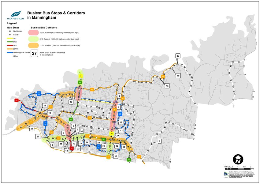
Busiest Bus Stops in Manningham
Table 4 below identifies the 30 busiest bus stops in Manningham, according to the average
number of weekday Myki transactions (touch on only) registered by GPS at these locations (PTV,
2016). A map illustrating the location of these bus stops is provided as Appendix D.
Table 4 – Most Utilised Bus Stops in Manningham
Rank Bus Stop Direction Suburb
1 Doncaster Westfield Bus Interchange Interchange Doncaster (Hill)
2 The Pines SC Bus Interchange Interchange Doncaster East
3 Doncaster Park & Ride Interchange Doncaster
4 Doncaster Rd @ Tram Road Eastbound Doncaster (Hill)
5 Williamsons Rd @ Doncaster Rd Southbound Doncaster (Hill)
6 Doncaster Rd @ Williamsons / Tram Rd Westbound Doncaster (Hill)
7 Blackburn Rd @ Canopus Dr Southbound Doncaster East
Manningham Bus Network Review 2017 | P a g e 15Rank Bus Stop Direction Suburb
8 Blackburn Rd @ Thomas Hardy Dr Southbound Templestowe
9 Park Rd @ Whitefriars College Southbound Donvale
10 Yarra St @ Webb St Westbound Warrandyte
11 Doncaster Rd @ Rose St Westbound Doncaster (Hill)
12 Doncaster Rd @ Clay Dr Westbound Doncaster (Hill)
13 Thompsons Rd @ Manningham Rd Southbound Templestowe Lower
14 Doncaster Rd @ Church Rd Westbound Doncaster
15 Heidelberg-W’dyte Rd @ W’dyte Reserve Westbound Warrandyte
16 Thompsons Rd @ Manningham Rd Northbound Bulleen
17 Blackburn Rd @ Eastern Fwy Southbound Doncaster East
18 Blackburn Rd @ Andersons Creek Rd Southbound Doncaster East
19 Elgar Rd @ Hanke Rd Southbound Doncaster
20 Yarra St @ Warrandyte Bridge Terminus Southbound Warrandyte
21 High St @ Ayr St Northbound Doncaster
22 Doncaster Rd @ Whittens Lane Westbound Doncaster
23 Doncaster Rd @ Pleasant Ave Westbound Doncaster
24 James St @ Templestowe Village SC Westbound Templestowe
25 Doncaster Rd @ Tunstall Square SC Westbound Doncaster East
26 Thompsons Rd @ Hugo St Southbound Bulleen
27 Doncaster Rd @ Jackson Ct Westbound Doncaster East
28 Doncaster Rd @ Blackburn Rd Westbound Doncaster East
29 Blackburn Rd @ Doncaster Rd Southbound Doncaster East
30 Blackburn Rd @ Beverley St Southbound Doncaster East
The three (3) busiest bus stops are the major interchanges in Manningham – at Westfield
Doncaster (with an average 1,270 weekday ‘touch on’ Myki transactions recorded), The Pines
Shopping Centre (with 743 ‘touch on’) and Doncaster Park & Ride. It could be assumed that
Doncaster Park & Ride is actually the second busiest bus stop in Manningham. However due to
the inaccuracy of the Myki and GPS
FIGURE 7 - LOCATION AREA
data and the delay in passengers
‘touching on’ due to the vast numbers
OF 27 BUSIEST STOPS
of passengers entering the peak-hour Other areas
(5/27)
buses, the GPS at times captures the Doncaster Rd
(including
data as passengers ‘touching on’ at
Warrandyte Doncaster
the next bus stop located at the area Hill)
inbound on-ramp entrance to the (3/27) (10/27)
Eastern Freeway from Doncaster Road
(located within the City of Thompsons Rd
(3/27) Blackburn Rd
Boroondara). (6/27)
Figure 7 shows where the remaining 27 busiest bus stops are located along key corridors. It is
noted that six (6) of the busiest bus stops are located within the Doncaster Hill precinct.
Manningham Bus Network Review 2017 | P a g e 16Busiest Bus Corridors in Manningham
Many of Manningham’s arterial roads cater for a considerable number of bus services per day.
Table 5 below identifies the number of services (on an average weekday) along the busiest
sections of our arterial road network. This information is also represented on a map in Appendix
D:
Table 5 – Top 15 Busiest Bus Corridor Sections in Manningham
Bus Daily
Sections between: Number of Lanes vehicle
daily bus Exist? Traffic
Rank Road Name services* Volume**
Westfield Doncaster No 13,000
Williamsons (Sovereign Point Ct) & 602
1 Road Manningham Road (400m) (6 routes)
Westfield Doncaster No 13,000
Williamsons (Sovereign Point Ct) & 590
2 Road Doncaster/Tram Road (450m) (5 routes)
Blackburn King St & Reynolds Rd 440 No 16,800
3 Road (1.3 km) (3 routes)
Blackburn George St & Andersons Creek 432 No 10,000 –
4 Road Rd (500 metres) (3 routes) 13,000
Williamsons Porter & Foote Streets 392 Yes 19,500
5 Road (800 metres) (4 routes)
Doncaster Church Rd & Williamsons Rd 376 Yes & No 14,000
6 Road (1.2 km) (4 routes) (Partly)
Fitzsimons Yarra River & Porter St 352 Sth – Yes 25,500
7 Lane (1.3 km) (3 routes) Nth – No
Doncaster Church & Wetherby Roads 336 Yes 12,500
8 Road (500 metres) (3 routes)
Blackburn George St & Eastern Freeway 300 No 9,700 –
9 Road (2.1 km) (2 routes) 12,000
Doncaster High St & Williamsons Rd 292 Yes & No 10,000
10 Road (1.8 km) (3 routes) (Partly)
Doncaster/ Wetherby & Springvale Roads 290 Yes 10,000
11 Mitcham Rds (3.5 km) (2 routes)
Thompsons Bulleen & Manningham Roads 276 No 8,000^
12 Road (2.1 km) (3 routes)
Manningham High St & Williamsons Rd 258 Yes 13,500
13 Road (1 km) (3 routes)
Manningham Thompsons Rd & Ayr St 248 No 11,000 –
14 Road (550 metres) (3 routes) 16,000
Parker/ Swilk High & Anderson Streets 234 No 12,100
15 / James Sts (1 km) (3 routes)
* Per weekday in both directions (based on PTV Timetable Information, PTV 2017)
**Bidirectional (Source: VicRoads, 2017)
^Daily Traffic volumes on Thompsons Road between Bulleen Road & the Eastern Freeway (outbound onramp) is higher at
17,000 eastbound and 11,000 Westbound.
Manningham Bus Network Review 2017 | P a g e 17The busiest bus corridor in Manningham is on Williamsons Road at the Westfield Doncaster bus interchange (Sovereign Point Court), with around 300 daily bus trips in each direction from this point north to the Manningham Road and Doncaster Road intersections. Other busy bus corridors are concentrated along Blackburn Road, Doncaster Road and Fitzsimons Lane. Bus lanes exist along some of Manningham’s busiest bus corridors, namely along Doncaster Road and Fitzsimons Lane and in parts of Mitcham, Manningham and Williamsons Roads. There are no bus lanes along the entire Blackburn Road corridor, in particular, the area around the busy George Street intersection (Donburn Village shops). This is another identified pinch-point due to the reduced speed limit, pedestrian activity and traffic movements in and around the shopping strip (Donburn Village). There are also no bus lanes or bus priority measures where Thompsons Road approaches the Eastern Freeway on-ramp and Bulleen Road in Bulleen which is regularly plagued by traffic congestion in the morning peak period. Doncaster / Mitcham Road Corridor The Doncaster / Mitcham Road corridor (8.4 km between the Eastern Freeway and Park Road) is one of the busiest bus corridors in Manningham (by number of commuters), catering for two highly-patronised SmartBus services (the 907 DART and 902 Orbital), along with several local services. Eleven (11) of the 30 busiest bus stops in Manningham are located along this corridor (including the Doncaster Park & Ride). This corridor also intersects with a number of other busy bus corridors or destinations, including Blackburn Road, Williamsons Road and Mitcham railway station. A bus trip on DART route 907 between Mitcham Station and Doncaster Park & Ride (a distance of 10 kilometres) can generally take 28 minutes on an average weekday (varies between 22 and 33 minutes depending on the time of day), travelling at an average speed of 21kph. Currently, there is a 550 metre gap where bus lanes do not exist along Doncaster Road through Doncaster Hill (between Beaconsfield and Council Streets) which is an identified pinch-point for buses (due to traffic volumes and signal phasing at the various intersections at Elgar, Williamsons and Tram Roads). There are 52 bus stops along this corridor (27 outbound, 25 inbound) spaced on average 320 metres apart, with almost two-thirds containing a bus shelter (namely at bus stops on the inbound route – 22 out of the 25). However, less than half (11 of the 27) of the bus stops on the outbound route contain a bus shelter. Six of the 52 stops contain an electronic real-time information board, providing up-to-date bus arrival times based on GPS data. Blackburn Road Corridor The Blackburn Road corridor (5.7 km between the Eastern Freeway and Heidelberg-Warrandyte Road) is another busy bus corridor in Manningham, catering in parts for four SmartBus services (the 905, 906 and 908 DART and 901 Orbital), along with several local services. Six of the 30 busiest bus stops in Manningham are located along this corridor (not including The Pines Bus Interchange). Manningham Bus Network Review 2017 | P a g e 18
A bus trip on DART route 906 between The Pines Bus Interchange and the Eastern Freeway (a
distance of 4.3 kilometres) can generally take 14 minutes on average (varies between 12 and 16
minutes depending on the time of day). Currently, there are no bus lanes along the entire length
of Blackburn Road, although some sections are identified pinch-points for buses (due to traffic
congestion), notably at the George Street and Doncaster Road intersections.
There are 33 bus stops along this corridor (16 northbound/outbound, 17 southbound/city-
bound) spaced on average 340 metres apart, with just over half containing a bus shelter. Eighty-
two per cent of bus stops on the city-bound approach contain a shelter (14 of 17). Only 19% (3 of
16) of outbound stops contain a shelter.
Manningham Road Corridor
Only a one kilometre section of Manningham Road between High Street and Williamsons Road
(an area which forms as the thirteenth busiest bus corridor in Manningham) provides dedicated
bus lanes (in both directions) There are no bus lanes provided along the remaining 3.8 kilometres
between High Street and the Yarra River bridge crossing to Heidelberg.
There are 28 bus stops along this 4.8 kilometre corridor between the Yarra River and Williamsons
Road (14 in each direction) spaced on average 340 metres apart, with half containing a bus
shelter – being 57% of the eastbound stops (8 of 14) and 43% of the westbound stops (6 of 14).
Characteristics of Bus Corridors outside of
Manningham
Given the significant level of demand for bus services between Manningham and the CBD, a large
majority of Manningham’s bus routes travel via the Eastern Freeway, Hoddle Street, Victoria
Parade and Lonsdale Street corridors, including all four (4) DART services.
The following outlines some characteristics of the Eastern Freeway and Hoddle Street corridors,
in how they relate to bus services.
Eastern Freeway
Carries between 135,000-160,000 vehicles (volume) per day [VicRoads, 2017].
Slowest freeway in Melbourne – average speed in AM peak: 9 km/h [VicRoads, 2015].
Eleven (11) different bus routes use the Freeway during the weekday peak.
Approximately 756 bus trips along the Eastern Freeway (in both directions) per day (378
in each direction).
Hoddle Street
Serves as the busiest bus corridor in Melbourne.
Bus commuters account for one-third (36 %) of all people who move along Hoddle
Street.
Approximately 932 bus trips each weekday (in both directions).
Manningham Bus Network Review 2017 | P a g e 19 Two-thirds of buses using Hoddle Street are destined for Manningham.
In the peak, one bus every minute exits the Eastern Freeway onto Hoddle Street
[VicRoads, 2017].
In the PM peak, buses can take up to 25 minutes to reach the Eastern Freeway from the
CBD (Spring Street) – a distance of less than 4 km.
In late 2017, VicRoads is due to commence construction of the Streamlining Hoddle Street
project – which will include the upgrade of the Johnston Street and Hoddle Street, and Eastern
Freeway and Hoddle Street intersections to improve the movement of people, buses and
vehicles along the Hoddle Street and Punt Road corridors. This project will also implement 24/7
Clearways along the entire length of Hoddle Street in order to enable the provision of dedicated
bus lanes in both directions. VicRoads predict that the project will improve travel time for buses
travelling the 1.5 kilometres between the Eastern Freeway and Victoria Parade by up to five
minutes [Streamlining Hoddle Street Information Update – September 2017, VicRoads].
Pedestrian Access to Bus Stops
In 2016, the RACV undertook a review of missing footpath connections to low and high use bus
stops throughout outer metropolitan Melbourne. The findings are contained in the Association’s
‘Footpath Connect: Outer Melbourne Footpaths’ document.
The RACV’s assessment of footpaths and bus stops within the City of Manningham concluded
that there are three (3) high-use stops that do not provide footpath access (totalling 300 metres
in missing paths) and 65 low-use bus stops that are missing footpath links (totalling 10.2
kilometres of missing path).
The three (3) high-use bus stops missing a connecting footpath are:
1. Templestowe Lower: Parker Street (south side of road) between Omar and High Streets
(165 metres);
2. Templestowe: Heidelberg-Warrandyte Road (south side of road) and east of Rosco Drive
(35 metres); and
3. Doncaster: Victoria Street (west side of road) between Owens Street and southern
entrance to the Ruffey Lake Park carpark (105 metres).
Council has also identified, through its own assessments, opportunities to improve pedestrian
access and safety around bus stops as part of the Principal Pedestrian Network (PPN), Walk
Manningham Plan 2011-2020, Safe Pedestrian Crossing Points Plan (2015) and the Bicycle
Strategy (2013). Actions included in these strategies will be progressively delivered by Council
over coming years, through its annual Capital Works Program.
It is generally considered that the footpath network in Manningham is currently well developed
in areas west of the Mullum Mullum Creek, with the exception of the Templestowe area, but is
limited in areas east of the Mullum Mullum Creek, including Park Orchards, Warrandyte and
Wonga Park. In order to deliver further improvements for pedestrians, Council has allocated a
Manningham Bus Network Review 2017 | P a g e 20significant annual budget through its 10 year Capital Works program, subject to an annual assessment of project priorities, to deliver the PPN, which includes 564 kilometres of footpaths. Collectively, these plans also identify locations in which to provide safe pedestrian crossing points – particularly across arterial roads, where long sections of arterial roads do not provide a safe point of crossing for pedestrians (up to, and at times exceeding, one kilometre in parts – See Figure 8, Walk Manningham Plan 2011-2020). Myki In order to travel on public transport in Victoria, one must carry a valid Myki card for ticket transactions. Myki cards can be purchased online or via the call centre, premium train stations, from ticket vending machines at some tram or bus hubs or from participating retailers (such as newsagencies, pharmacies and some local milk bars and all 7-eleven stores). You can also buy a myki on board a bus within the myki area and top up to a maximum of $20.00. Figure 8 illustrates locations around Manningham to buy or top up a Myki. As illustrated, you can do this at all three major bus interchanges at Westfield Doncaster, The Pines Shopping Centre and Doncaster Park & Ride, including several retailers and 7-eleven stores. However, you are unable to do this in the areas of Templestowe Lower, Warrandyte, Warrandyte South or Wonga Park. Figure 8 – Locations in Manningham to buy or top up Myki Source: PTV, 2017 Manningham Bus Network Review 2017 | P a g e 21
3. OTHER RELEVANT BUS
NETWORK REVIEWS
This current Review has been prepared with consideration of the objectives and
recommendations of previous bus network reviews that have been undertaken by either State
Government (i.e. PTV), Transdev or Manningham City Council. Some of the recommendations
highlighted by those reviews are still deemed appropriate and contribute to this review.
Public Transport Victoria: A New Bus Network for the Eastern Suburbs
(2015)
The most significant of these earlier reviews was undertaken by PTV in consultation with
Transdev and Council in 2014 and 2015, whereby the existing eastern suburbs bus network was
subject to a Greenfields Timetable Review to identify opportunities to enhance the network by
increasing service frequencies (particularly on DART and SmartBus), re-routing or truncating
services to provide more direct routes and, in some cases, introducing a new route altogether.
However, these changes were intended to be implemented on cost-neutral and no-additional-
kilometre basis, which would have meant the loss of services to other parts of Melbourne.
Subsequently, in late 2015, most of these suggested changes were scrapped by the incoming
government at the time (although a few changes have since been implemented, such as
improved weekend services on DART route 907). Many of those suggested changes are still
generally supported by both Council and Transdev, pending further consultation with the
community. These include the following improvements:
DART:
Routes 905 and 906: significantly increase capacity and frequency of peak weekday
services with the introduction of greater-capacity buses
Route 907: significantly increase capacity of all weekday and weekend services (with the
introduction of greater-capacity buses) and boost frequency from every 15 to 10
minutes off-peak on weekdays and from every 30 to 20 minutes on weekends
Route 908: increase weekend frequency from every 30 to 20 minutes
All DART routes: Generally improve the frequency of evening and weekend services on
all routes, and provide late-night services (midnight to sunrise) on Friday and Saturday
nights
SmartBus Orbital:
SmartBus orbital Routes 901 and 902: increase weekday peak frequency from every 15
to 10 minutes and weekend frequency from every 30 to 20 minutes
Manningham Bus Network Review 2017 | P a g e 22 SmartBus orbital route 903: boost weekday peak frequency from 10 to every 7.5
minutes, Saturday services from every 30 to 10 minutes and Sunday services from every
30 to 20 minutes
Further investigate opportunities to truncate the three orbital routes to improve overall
reliability and travel times
Local Routes:
Reintroduce a direct bus service between The Pines SC and Box Hill (in place of the
former route 286)
Introduce a new regular (weekday and weekend) service between Templestowe Village
(or possibly The Pines SC) and Heidelberg Station along Templestowe Road in Bulleen
Route 271 (Box Hill to Ringwood): provide a more direct service and introduce a Sunday
service (with a minimum frequency of every 30 minutes)
Route 309 (The Pines SC to City): expand to a regular weekly service (by introducing
weekend services)
Route 318 (Deep Creek Reserve to City): increase peak services from four to 18 per
weekday
Route 364 (Ringwood to Warrandyte): increase weekend frequency from hourly to half-
hourly and extend this service to The Pines SC.
It should be noted that further consultation will need to be undertaken with Council, commuters
and the local community if and when these changes are further explored or reconsidered.
Manningham Local Bus Services Review (2012)
This current review is intended to update the recommendations of an earlier and similar review
conducted by Council in 2012. Some of the outstanding recommendations are proposed to be
carried over to this current review in the context of a revised assessment of patronage, service
levels, bus shelter priorities and identification of issues.
Manningham/Whitehorse/Monash Metropolitan Bus Services Review
(2010)
In 2010, the former Department of Transport released its Manningham/Monash/Whitehorse Bus
Services Review. That review was one of 16 to be conducted across Melbourne and was a key
action of the then Victorian Government’s Transport Plan ‘Meeting our Transport Challenges’,
released in 2006.
A number of key recommendations of that review should also be carried forward as
recommendations of this current review. These include:
To ensure that a bus stop is provided within 400 metres, or a 5 minute walk of 90% of
every Manningham household; and
To achieve minimum service standards to provide a bus service at a minimum frequency
of every 30 minutes between 6.00am and 9.00pm on weekdays, 8.00am and 9.00pm on
Saturdays and 9.00am and 9.00pm on Sundays, particularly on local suburban routes.
Manningham Bus Network Review 2017 | P a g e 234. INFLUENCES AND
OBSERVATIONS
In the five years since the last Review was conducted, a number of changes to the bus and public
transport network have occurred, contributing in some way to the current state of the bus
network.
Issues surrounding a lack of reasonable public transport and access are commonly the most
raised concerns that Manningham residents have regarding the local area, in particular, the lack
of frequent and high-capacity public transport options available to many parts of the municipality
[1000s of Voices = 1 Manningham, Manningham City Council, 2016]. There is strong community
support for improved public transport options to the City of Manningham, either through a
heavy rail line to Doncaster, greater capacity of DART or generally more frequent and reliable bus
services.
The following are some of the influences that have contributed to the nature of the existing bus
network over the past five years:
The significant growth in DART patronage and ability of the network to cope with the
demand (capacity constraint of the existing bus fleet and road network);
A change to ticket fare zoning in 2015 (which applied a Zone 1 fare to the entire
municipality);
The loss of the direct Box Hill to The Pines bus service (route 286) in 2015;
The ongoing impact of growing traffic congestion to bus reliability;
Higher density development – particularly around Doncaster Hill (referred to on page 33
of this report) and along the Doncaster Road corridor;
A decline in the number of young Victorians who have a driving licence;
A softening in the average cost of fuel, with the average price per litre falling from $1.40
in 2011 to $1.12 in 2016 [RACQ, 2016].
According to data provided by VicRoads and analysed by Monash University, the proportion of
young Victorians who have a driving license has continued to decline. In 2001, 75% of 18 to 23
year olds and 93% of 24 to 30 year olds had a provisional or full driving licence. In 2016, this
declined to 62% and 82% respectively [VicRoads/Monash University, 2016]. These figures may
indicate that more and more younger people are reliant on public transport for their travel
needs.
Since 2012, a number of infrastructure improvements have also been made, including the
construction of the new Kiss & Ride facility in Bulleen, provision of bus lanes along Fitzsimons
Lane and Williamsons Road in Templestowe and Victoria Parade in East Melbourne and bus
Manningham Bus Network Review 2017 | P a g e 24priority improvements at many key intersections, including High Street / Doncaster Road, Williamsons Road / Foote Street and Williamsons Road / Porter Street. These projects have all collectively contributed to improving bus priority and reliability on these roads. The change in the ticket fare zone pricing across Melbourne has also led to a reduced demand and patronage at bus stops in Zone 1 which, in the City of Manningham, are all located in Bulleen within the vicinity of Thompsons Road near the Eastern Freeway interchange. Given this, the streets around this precinct have experienced less demand for commuter parking as commuters are no longer attracted to these bus stops in order to pay a lower ticket fare. In addition, patronage at the new Kiss & Ride facility, which was completed in mid-2016, has also been lower than expected. However, the change to the fare arrangements has also benefited Manningham commuters, as the cost of a trip between Manningham and the CBD has effectively halved in price. Table 6 (overleaf) lists some of the identified issues that exist with the current bus network and services and provides suggestions for how to address these issues. The majority of suggestions outlined in this table form the key recommendations of this Review. A map illustrating the location of suggested bus lanes in Manningham is provided as Appendix E. Some improvements may require further advocacy by Manningham City Council to secure priority and funding to implement, as the responsibility may lie with various agencies or authorities. Many of these changes will also require consultation with existing commuters and the general community. These issues have been identified through various methods of feedback received from the community and public transport users through community consultation forums, correspondence to Council and one-on-one discussions between Council officers and community members. These issues have also been identified through the observations made by Council, Public Transport Victoria, VicRoads, Transdev (corporate and drivers) and other local bus operators. Manningham Bus Network Review 2017 | P a g e 25
Table 6 – Observations, issues and suggestions
Issue Topic Issue Suggestion Responsible
Authority
GENERAL SERVICE LEVELS
Overcrowded DART services 905, 906 and 907 experience regular Boost frequency of DART buses in the peak and PTV / TfV
DART services overcrowding during peak periods. This is most significant at provide higher capacity buses to cater for growing
bus stops located closest to the Eastern Freeway (Doncaster, demand.
Blackburn and Thompsons Roads), as buses are usually already
full by this stage in the AM peak.
Manningham Services cease in the early evening and buses face delays in the Extend Manningham Mover (route 280/2) hours of PTV / TfV /
Mover services PM peak at Manningham and Bulleen Roads. operation to at least 8pm on weekdays. Transdev
Re-route service 282 through Noelle Street in
Bulleen, to avoid the Bulleen/Manningham Road
intersection.
Lack of regular Many local bus routes do not operate regular services on Improve frequency of all services to provide a PTV / TfV /
frequency and weekends (mainly Sundays) and often cease to operate early minimum 30 minute frequency every day of the Transdev
weekend bus on weekday evenings. week.
services Provide a Sunday service to routes 271 and 285.
Consider the implementation of ‘on-demand bus
services’ for areas that currently lack adequate and
regular bus services (including the Warrandyte, Park
Orchards, Donvale and Wonga Park areas).
Review Some routes that service Manningham are not direct and Investigate opportunities to simplify local bus routes PTV / TfV /
meandering meander through a number of local streets, increasing travel by making them more direct and easier to Transdev
bus routes times and discouraging potential commuters due to the time it understand by the general community – namely on
takes to get between their origin and destination. routes 271, 273, 279 and 295.
Lack of Inadequate frequency of some services between Manningham Re-introduce a direct service between The Pines SC PTV / TfV
adequate bus and Box Hill including no direct service between The Pines SC and Box Hill (formally route 286).
services to Box and Box Hill.
Hill
Manningham Bus Network Review 2017 | P a g e 26You can also read