Manual Open Space Land Valuation 2021 - For - Freestone Central Appraisal District
←
→
Page content transcription
If your browser does not render page correctly, please read the page content below

Manual
           For
Open Space Land Valuation
          2021

                       March 2021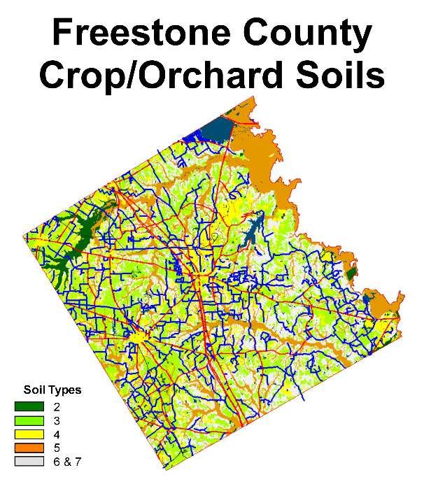
2

Table of Contents

I. INTRODUCTION .....................................................................................................................................................5
   “AG VALUE” ..............................................................................................................................................................5
II. ELIGIBILITY REQUIREMENTS .............................................................................................................................5
   (A) ELIGIBLE PROPERTY ...........................................................................................................................................5
   (B) INELIGIBLE LAND .................................................................................................................................................6
III. TYPES OF AGRICULTURAL USE........................................................................................................................6
   (A) VALID AGRICULTURAL USES ................................................................................................................................6
   (B) INVALID AGRICULTURAL USES..............................................................................................................................7
IV. QUALIFICATION REQUIREMENTS.....................................................................................................................7
   (A) CURRENT USE ....................................................................................................................................................7
   (B) PRIMARY USE .....................................................................................................................................................7
   (C) HISTORICAL USE.................................................................................................................................................8
   (D) INTENSITY USE ...................................................................................................................................................8
   (E) ECOLOGICAL LABORATORIES ...............................................................................................................................8
   (F) QUALIFICATION LIMITATIONS ................................................................................................................................8
V. APPLICATION FOR OPEN SPACE PRODUCTIVITY APPRAISAL .....................................................................9
   (A) FILING DEADLINE ................................................................................................................................................9
   (B) LATE APPLICATION ..............................................................................................................................................9
   (C) ONE TIME APPLICATION ................................................................................................................................... 10
VI. CHIEF APPRAISER’S ACTION ......................................................................................................................... 10
   (A) ADDITIONAL INFORMATION ................................................................................................................................ 10
   (B) DENIAL OF APPLICATION ................................................................................................................................... 11
VII. NOTIFICATION OF CHANGES IN ELIGIBILITY BY LANDOWNER ................................................................ 11
VIII. CHANGE OF USE............................................................................................................................................ 11
IX. PRODUCTIVITY VALUE DEVELOPMENT & CONSIDERATIONS .................................................................. 12
X. SOIL Considerations ..................................................................................................................................... 12
   (A) SOIL CLASSIFICATIONS ..................................................................................................................................... 13
      The Post Oak Savannah (or Southern Claypan) ............................................................................................ 13
      The Northern Blackland Prairie ....................................................................................................................... 14
      The East Texas Timberlands .......................................................................................................................... 14
   (B) PRODUCTIVITY CAPABILITY ............................................................................................................................... 15
   (C) TOPOGRAPHY .................................................................................................................................................. 16
   (D) PARCEL SOIL TYPE IDENTIFICATION .................................................................................................................. 16

                                                                                    3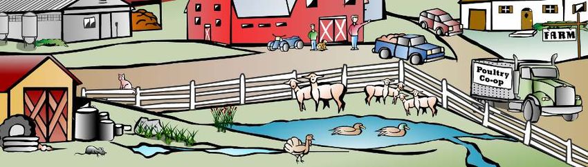
4
I. Introduction
Open Space Land Valuation, as authorized by Article VIII, Section 1-d-1 of the Texas Constitution, allows
qualifying lands to be appraised (and taxed) according to the lands capability to produce agricultural products.
These properties will be assigned both a market value and a productivity value by the appraisal district.
The Constitution permits special agricultural appraisal only if land and its owner meet specific requirements
defining farm and ranch use. Land won’t qualify simply because it is rural or has some connection with agriculture.
Neither will it qualify because it is open land that has no other possible use. The law does not guarantee a tax
break for everyone who makes a living from the land. Casual uses such as home vegetable gardens do not really
constitute agriculture.
Section 23.51 of the Property Tax Code sets the standards for determining whether land qualifies:
“Qualified open-space land means land that is currently devoted principally to agricultural use to the
degree of intensity generally accepted in the area.”
To qualify his land for agricultural appraisal, the property owner must show the chief appraiser that his land meets
the Sec. 23.51 standard. To do so, the property owner must apply for the appraisal. The owner must give the
chief appraiser all the information he needs to determine whether the land qualifies. The property owner must also
inform the chief appraiser of any changes in the status of his land.
Land may qualify for the special valuation if it is used for:
Farming and/or ranching,
Timberland management and production, or
Wildlife management.
This set of guidelines speaks specifically to the considerations for farming and/or ranching agricultural uses.
Guidelines for Timberland Management and Guidelines for Wildlife Management speak to the considerations for
open space land valuation for these two types of agricultural productivity valuation.
“Ag Value”
Open Space Land Valuation has come to be referred to as “ag value” by the general public and, by necessity
during communication with the general public, by CAD personnel.
In these guidelines, the word “agricultural appraisal” refers to the special valuation that land that is used for
farming and/or ranching purposes may receive it if meets the qualification requirements.
II. Eligibility Requirements
(A) Eligible Property
Agricultural appraisal applies only to land and its potential for agricultural production. Man-made alterations of, or
additions to, the land are appraised as part of the land. These appurtenances to the land—canals, water wells,
roads, stock tanks, and other similar reshaping of the soil—are included in the value of the land and are not
separately appraised.
Land must be of an adequate size to support a typically prudent agricultural operation as determined by the Ag
Advisory Board in the Freestone County Agricultural Intensity Standards attached in Addendum 1.
Smaller sized properties will not generally qualify for the special use valuation. Consideration will be given to
these tracts if any one of the following conditions are met:
Smaller contiguous tracts will be considered when all of the following are true:
1. The agricultural use and operator of both parcels are the same,
2. There is no physical barrier such as a fence or road that separates the parcels, and
3. The aggregate acreage meets the minimum size requirements; or,
5
Smaller tracts of intensive agricultural operation such as plant nurseries or vegetable truck farms.
Appraisers should be aware that exceptions may arise that call for special consideration and evaluation of size
requirements on an individual basis.
Agricultural appraisal does not apply to:
Improvements. Buildings and structures such as barns, sheds, or other outbuildings must be appraised
separately at market value. Fences, however, are appurtenances and are not appraised separately. Land
beneath outbuildings and other improvements related to agricultural use qualify for the special appraisal
because the owner uses it in the timber producing operation.
Minerals. Oil, gas, or any hard mineral must be appraised separately at market value.
(B) Ineligible Land
Land that is located inside the city limits is ineligible for qualification as open-space land unless the land
has been devoted principally to agriculture use for the preceding five years.
Land that is owned by a nonresident alien, foreign government, corporation, partnership, trust, or other
legal entity is ineligible for qualification as open-space or timber land unless the treaty between the United
States and a foreign government includes a non-discrimination clause. PTC Sections 23.56 & 23.77 (and
notes).
III. Types of Agricultural Use
(A) Valid Agricultural Uses
Section 23.51(2), Property Tax Code, defines the term “agricultural use” as including the following activities:
Cultivating the soil.
Producing crops for human food, animal feed, or planting seed or for the production of fibers.
Floriculture-Floriculture is the cultivation and management of ornamental and flowering plants.
Viticulture-Viticulture is the cultivation of grapes.
Horticulture-Horticulture is the cultivation of fruits, vegetables, flowers, herbs, or other plants.
Raising or keeping livestock. “Livestock” means a domesticated animal that derives its primary
nourishment from vegetation, supplemented as necessary with commercial feed. Livestock includes
meat or dairy cattle, horses, goats, swine, poultry, and sheep. Wild animals are not livestock.
Beekeeping (with minimum acreage requirements)
Raising exotic game for commercial use. Exotic game means a cloven-hoofed ruminant mammal that
is not native to Texas and is not “livestock.” Raising such game may qualify but must meet the
primary use test discussed on page 10.
Participation in a government program and normal crop rotation. Land left idle to participate in a
government program is used for agriculture. Land left idle for crop rotation qualifies until it is left idle
for longer than the crop rotation period typical for the crop in the area.
This list is not exhaustive. Production of any commercially valuable livestock, fish, or poultry product probably
constitutes agricultural use as well. For example, the Texas Attorney General has ruled that agriculture includes
6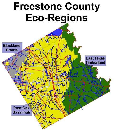
the term “mariculture” and that land used to produce fish and other forms of aquatic life can qualify for an
agricultural appraisal. Op. Tex. Att’y Gen. No. JM-87 (1983).
Land used to harvest wood for building uses may qualify in specific circumstances. To qualify, the land must be
adjacent to qualified 1-d-1 land owned by the same person. Also, the wood must be used only to build or repair
fences or agricultural improvements on the adjacent property.
(B) Invalid Agricultural Uses
Some agriculture-related activities that do not qualify land for agricultural appraisal are:
Harvesting native plants or wildlife-Harvesting shrubs that grow wild on the land—mountain laurel,
yaupon, etc.—or harvesting or hunting native wild animals such as deer or turkey will not qualify land.
Processing plants or animals- Activities that take place after the crop or animal has been raised
and harvested do not qualify land for special appraisal. Activities such as pasteurizing and bottling
milk; fermenting grapes and bottling wine; or slaughtering, dressing, and packing meat will not qualify
land for agricultural appraisal.
IV. Qualification Requirements
To qualify for agricultural appraisal, landowners must meet each of the following eligibility requirements:
The land must be currently devoted to a qualifying agricultural use to the degree of intensity that is typical
in the area,
The qualifying agricultural use must be the primary use of the property,
The land must have been used principally for agriculture or timber production for any five of the preceding
seven years, and
The property owner must file a valid application form.
Additionally, applicants must be aware that:
Agricultural appraisal applies to the land and not to other property that may be connected with the land.
Land owned by a foreigner is ineligible for agricultural appraisal;
Land inside city limits has more stringent qualification requirements and may be ineligible; and,
Land used as an ecological laboratory may qualify for agricultural appraisal.
A “rollback” tax may be assessed against the property when the property’s use is changed.
(A) Current Use
Land must be currently used for a qualifying agricultural purpose on January 1 to be considered for the special
valuation. In the event that agricultural use is not evident on January 1, the chief appraiser should grant
productivity valuation if the owner can show evidence that he intends to put the land into agricultural use and that
agriculture will be the primary use for the bulk of the calendar year covered by the application.
(B) Primary Use
According to the statute, land must be devoted principally to an agricultural use. If the land is used for more than
one purpose, the most important or primary use must be agriculture.
Other uses do not prevent land from qualifying if the primary use is agriculture. For example, land used primarily
to graze cattle could also be leased for hunting. Leasing land for deer hunting is compatible with a primary use of
land for grazing cattle.
The appraiser must determine which use is primary. If one of these other uses replaces agriculture as the primary
use of land, then the land is no longer principally devoted to agricultural use and cannot qualify for agricultural
appraisal.
7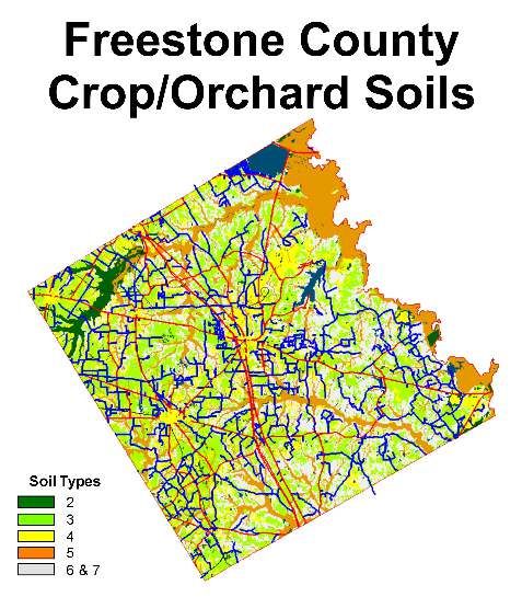
The primary use test is particularly important for the keeping of exotic game, fish, and horses since only
production for food or other commercially valuable products qualifies.
An exotic game ranch devoted solely to hunting could never qualify for agricultural appraisal because
hunting is a recreational use. Many game ranches also offer recreational hunting as a way of earning
income and managing a herd of breeding stock.
A ranch that produces exotic game products and conducts recreational hunts may or may not qualify for
special appraisal. Qualification in such a case depends on which use is primary.
Commercial fish production differs from keeping game fish four purely sporting or recreational
purposes. This difference is not necessarily related to the scale of the operation, nor is it related to any
intent to produce income or make a profit. Raising fish is a qualified agricultural land use when all the
elements of a bulk harvest are present. Taking fish by individual line is clearly a recreational activity.
Land used primarily to raise or keep horses qualifies for agricultural appraisal; however, land used
primarily to train, show, or race horses, to ride horses for recreation, or to keep or use horses in some
manner that is not strictly incidental to breeding or raising horses does not qualify.
Land used to raise or keep horses primarily used to assist ranchers in herding livestock will qualify for
agricultural appraisal.
(C) Historical Use
The five out of seven years’ use requirement is self-explanatory. Use principally for agriculture in any five of these
seven years qualifies land for agricultural appraisal.
A property owner can also point to a history of timber production in meeting the five-year test. Land used primarily
for either timber or agricultural production during any five of the previous seven years may qualify and as long as
agriculture was the principal use in the preceding years, the land qualifies even if that use did not meet the degree
of intensity requirement in all or some of those years.
(D) Intensity Use
Land must be used to the degree of intensity test measures whether the land is being farmed or ranched to the
extent typical for agricultural operations in the county. The previous section described whether a particular use
was primarily “agricultural.” To receive a productivity appraisal, however, the land must also be used for an
agricultural purpose to the degree of intensity typical in the area. This test is intended to exclude land on which
token agricultural use occurs in an effort to obtain tax relief.
Relying upon the assistance and recommendations of the Freestone Agricultural Advisory Board, the chief
appraiser sets the standards according to local agricultural practices. Because of the variety of soil types, climatic
conditions, and crops in a state as large as Texas, no single statutory definition could cover all possible uses. A
copy of the most recently adopted Agricultural Intensity Standards for Freestone County is attached as
Addendum 1.
(E) Ecological Laboratories
Land used principally as an ecological laboratory by colleges or universities may qualify for agricultural appraisal.
The property owner must follow the same application procedures required to qualify other 1-d-1 land. The land
must be principally used as an ecological laboratory. In determining use, appraisers should apply the same
principles they use to identify the primary use of agricultural land. Landowners wishing to apply for the special
valuation under this section must file a form designed for ecological laboratories instead of the general open
space land valuation application. Ecological Laboratories do not have to meet the “five out of seven year
historical use” test to qualify but must meet the current use at the level of intensity standards.
(F) Qualification Limitations
Even if land meets all the preceding conditions, two situations may block approval of an application. These
situations are discussed in detail below.
8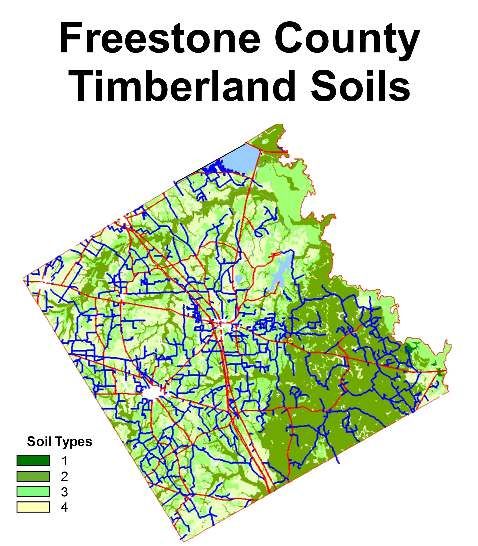
Land Located Within the Boundaries of a City or Town
Land within the boundaries oaf city often will not qualify. Land located within an incorporated city or town must
meet the criteria applicable to all land and must meet one of the
following:
the city must not provide the land with general services comparable to those provided in other parts of the
municipality having similar features and population; or
the land must have been devoted principally to agricultural use continuously for the preceding five years.
Land Owned by a Non-Resident Alien or Foreign Government
Some kinds of foreign ownership disqualify land. If the property owner is a non-resident alien (a non-U.S. citizen
who does not reside in the U-S-), the land can’t qualify.
Similarly, a corporation can’t qualify its land if non-resident aliens, foreign governments, or both control the
corporation. These owners are required by federal law to report ownership or transfers of agricultural land. Sec.
23.56(2) and (3), Property Tax Code, bars these owners from qualifying.
V. Application for Open Space Productivity Appraisal
Property owners must timely file an application for Open Space Land Valuation with the appraisal district.
Forms are available:
At appraisal district office
From the district’s website www.freestonecad.org, or
From the State Comptroller’s website https://comptroller.texas.gov/forms/50-129.pdf
If the initial application is valid but does not contain all the information the district needs to rule on an application,
the chief appraiser may require the applicant to give additional information. This procedure is described later in
this section.
A property owner may file a single application form covering all tracts within an appraisal district. Owners need not
file a separate form for each tract as long as they provide sufficient information to show that all tracts qualify under
the law.
If a person does not file a valid application before the appraisal review board approves the appraisal roll,
the land is ineligible for productivity appraisal in that tax year.
(A) Filing Deadline
An application must be postmarked or filed no later than midnight, April 30. For good cause and only on the
property owner’s request, the chief appraiser may extend the filing deadline in individual cases for not more than
60 days. The property owner must request an extension before the filing deadline.
The Tax Code does not define “good cause.” However, it is commonly something the applicant cannot control.
Illness or injury or an inability to transact normal business for a period that effectively prevents filing on time is
usually good cause. Each appraisal district should prescribe its good cause requirements.
(B) Late Application
A property owner who misses the deadline may file a late application until the appraisal review board approves
records for that year (usually about July 20). However, there is a penalty for late application. An application filed
after April 30 is subject to a penalty equal to 10% of the difference between the tax if imposed at market value and
9
the tax imposed at the productivity value. If the chief appraiser extended the deadline for that property owner, this
penalty does not apply.
The chief appraiser must note the imposition of the penalty in the appraisal records. The property owner must be
given written notice of the penalty and an explanation for its imposition. The tax assessor adds the penalty
amount to the tax bill and collects the penalty along with the annual tax payment.
A lien attaches to the property until the penalty is paid. If the penalty remains unpaid on February 1 of the
following year (or a later delinquency date if tax bills are mailed late), penalty and interest on the penalty amount
accrue as if it were a delinquent tax.
(C) One Time Application
Once the application is filed and approved, the land continues to receive productivity appraisal every year without
a new application unless the ownership changes, the land’s eligibility changes, or the chief appraiser requires a
new application. The chief appraiser may require a new application if he or she has good cause to believe
that the land’s eligibility for productivity has ended. If the chief appraiser requires a new application, the
property owner must meet the deadlines that apply to a new applicant. To better inform the taxpayer, the chief
appraiser may wish to state in writing the reason for a new application.
VI. Chief Appraiser’s Action
The chief appraiser must review each application and decide whether to:
approve it and grant productivity appraisal;
perform a physical inspection of the property to determine eligibility and use to the intensity standards;
disapprove it and ask for more information; or
deny the application.
The chief appraiser must determine the validity of all timely filed applications before turning all appraisal records
over to the district's appraisal review board. The deadline is May 15 or as soon afterward as is practicable.
The chief appraiser usually gives the appraisal records to the appraisal review board (ARB) by May 15. Property
owners who were denied productivity appraisal may file a protest with the ARB. In addition, taxing unit officials
who believe productivity appraisal was erroneously granted to any property owner may seek to remove that grant
by filing a challenge with the ARB.
The chief appraiser must rule on all late-filed applications before the appraisal review board approves the records
for the year. The chief appraiser must notify the applicant in writing within five days of an application’s denial. This
notice must explain the procedures for protest.
(A) Additional Information
The chief appraiser may request additional information. If the initial application form is valid but the chief appraiser
does not have all the information needed to determine if the land qualifies, the chief appraiser may request
additional information. The chief appraiser may request only additional information that is necessary to determine
if the land qualifies for productivity appraisal. Information and/or documentation may include the following:
Sworn statements from lessors of subject property, owners of surrounding properties, or othere person’s
knowledge of ag use. Statements should describe how the property has been used and the period of
time used. Statements should be notarized.
Invoices for feed, veterinarian services, seed, fertilizer, etc.,
Receipts for sale of livestock, hay or farm products,
Income tax return showing farm income (Schedule F),
Current active lease.
The applicant must provide additional information within 30 days after the date of the request or the application
will be denied.
10If there is good cause, the chief appraiser may extend the deadline to allow additional information. An extension
cannot exceed 15 days.
(B) Denial of Application
If a chief appraiser denies an application, a notice of the denial must be delivered to the applicant within five days.
This notice must be sent by certified mail (See Section 1.07(d), Tax Code).
The notice from the chief appraiser will include a reason for denial and procedures for protesting to the appraisal
review board.
VII. Notification of Changes in Eligibility by Landowner
If land’s eligibility ends or its ownership changes, the property owner must notify the appraisal office in writing
before the next May 1.
New owners are not eligible for timberland productivity appraisal unless they apply. If the owner fails to do so, one
or more penalties will apply.
If the land remains under the same ownership and the owner fails to inform the appraisal district that the land is
no longer eligible for productivity appraisal, either because the land is no longer in timber use or because the
degree of intensity has fallen below that typical for the area, the property owner must pay a penalty equal to 10%
of the difference between the taxes imposed under the timber use and the taxes that would have been imposed
under the new use. This penalty applies for each year the property received the incorrect appraisal, but for no
more than five years.
If the property erroneously receives productivity appraisal because a new owner failed to file an application or
other reason, the chief appraiser must calculate the difference between the land’s market value and its
productivity value. The owner must pay taxes and penalties on the difference between these values for the time
that the land erroneously received productivity appraisal, plus a 10% penalty on these taxes. This additional tax
and penalty may not cover a time period exceeding five years. In the year the chief appraiser discovers the
change, the chief appraiser should add this value to the appraisal roll as property omitted in a prior year.
When a penalty is imposed, the chief appraiser must notify the property owner. This notice must explain the
procedures for protesting the penalty. The chief appraiser notes the imposition of the penalty in the appraisal
records, and the tax assessor adds the amount of the penalty to the property’s annual tax bill.
VIII. Change of Use
When land that has been receiving special valuation is taken out of 1-d-1 agricultural use, the law provides that a
rollback tax be assessed. The rollback tax equals the difference between the taxes the owner actually paid in the
five years preceding the change in use and the taxes the owner would have paid on his property's market value.
Technically, the tax is a new, additional tax imposed by law on the date the change of use occurs. It has its own
delinquency date, and it does not exist until the event that triggers the rollback occurs. Selling the property does
not trigger a rollback, nor does the cessation of use always trigger the rollback.
Additionally, a property owner may begin using a part of the property for a residence without triggering a rollback.
However, property cannot be deeded to someone else for the construction of a residence without the property
being subject to a rollback. If the property owner diverts only part of a property to a non-agricultural use, the
rollback tax only applies to the changed portion. Property sold or condemned fir right of way is not subject to
rollback.
Once the Chief Appraiser determines that a change of use has occurred, he must notify the property owner of the
decision to rollback the taxes on the property by:
1. Sending a written notice by certified mail, and a copy by first class mail, to the owner stating that the Chief
Appraiser believes the land may have been diverted to a nonagricultural use. The notice must include a
form on which the owner may indicate that the owner remains entitled to have the land designated for
open space or agricultural use. The notice must include a self-addressed postage repaid envelope with
instructions for returning the form to the Chief Appraiser.
11The Chief Appraiser shall consider the property owner's response on the form in determining whether the
land has been diverted to a nonagricultural use.
If the property owner returns statement to the Chief Appraiser agreeing with the determination, the Chief
Appraiser shall deliver a Change of Use Determination Notice to the property owner as described in Step
3 below.
2. If the Chief Appraiser does not receive a response on or before the 60th day after the date the notice was
mailed, the Chief must send an additional notice by first class mail in an envelope on which is written, in
all capital letters "RETURN SERVICE REQUESTED," or another appropriate statement directing the
Unites States Postal Service to return the notice if it is not deliverable as addressed.
The Chief Appraiser may attempt to notify the property owner in another manner that he determines to be
appropriate and constitutes a reasonable effort on his part.
3. 30 days after the second attempted notification to the property owner has expired, the Chief Appraiser
shall deliver a Change of Use Determination Notice to the property owner by certified mail and first-class
mail. The Change of Use Determination Notice shall include a statement regarding the property owners
right to protest and instructions for doing so.
Once the protest period has expired or the property owner has waived his right to appeal the rollback, the
tax assessor/collector prepares and delivers the rollback tax statement to the property owner for
collection.
It is important to note that tax certificates issued on parcels that are receiving the special valuation are noted that
the certificate does not cover any additional rollback taxes that may become collectable due to a change of use in
the property.
More specific information regarding change of use and rollback procedures can be found in the PTAD's Manual
for the Appraisal of Agricultural Land and Manual for the Appraisal of Timberland.
IX. Productivity Value Development & Considerations
Productivity value is determined using a methodology prescribed by Texas law and PTAD rules. In developing
productivity value schedules, the Chief Appraiser must use typical operating income and expense information
from the local market along with the productivity capacity of land by classification.
The district gathers information for typical owner income and expense streams from survey forms it sends to
agricultural producers in the county, the NRCS office, and PTAD survey data. Additional consideration is given to
the soil classification system determined by NRCS. Other assumption data considered in the calculation is
provided by the Agricultural Advisory Board of Freestone County.
Productivity value schedules are determined by the Chief Appraiser for the varying types of qualifying agricultural,
timber, and wildlife management uses found in the district. The most recent calculations are found in a report
attached as Addendum 2.
X. Soil Considerations
Open Space Land Valuation cost schedules are developed in accordance with the methods outlined in the
Property Tax Division’s Manual for the Appraisal of Agricultural Land, Manual for the Appraisal of Timber Land
and Guidelines for the Appraisal of Agricultural Land for Wildlife Management.
In developing its cost schedules for Open Space Land Valuation, the district considers factors that influence the
land's productivity capacity such as:
Soil type,
Soil Productivity capability,
12 Topography, and
Any other factors that influence land’s productive capacity.
To meet the requirement of Property Tax Code Section 23.51, the distinct must consider the capability of a
property’s soil to produce agriculture products, and timber, or to serve as a habitat for wildlife.
FCAD relies upon the Natural Resources Conservation Service’s Soil Survey of Freestone County, Texas for this
purpose. The survey:
“…was made to provide information about the soils and miscellaneous areas in the survey area. The information
includes a description of the soils, their location, and discussion of their suitability, limitations, and management
for specified uses. Soil scientist observed the steepness, length, and shape of the slopes; the general pattern of
drainage; the kinds of crops and native plants.”
A narrative description of the district's analysis is included annually in the Open Space Land Calculation
(Addendum 2).
(A) Soil Classifications
The NRCS Soil Survey of Freestone County Texas indicates that there are seventy-one (71) different areas within
the county with similar topography and soil types; however, the soils of Freestone County follow an orderly pattern
that is related to the geology, landforms, relief, climate, and natural vegetation of the area. Each kind of soil and
miscellaneous area is associated with a particular kind of landform or with a segment of the landform. Individual
soils on the landscape merge into one another as their characteristics gradually change. For purposes of the
determination of values for Open Space Land Valuation, the district has categorized all property into one of its
three major eco-regions, based upon its analysis of soil types, topography influences, and vegetation types
reported in the NRCS Soil Survey of Freestone County Texas.
Those regions are:
The Post Oak Savannah (or Southern Claypan)
Generally bounded by “Little Tehuacana Creek on the west to FM 1364 on the east. Communities in this are
Fairfield, Dew, Teague, Dew, Freestone, and Donie. It is dominated by light-colored loamy and sandy soils. The
native vegetation is oak trees with and understory of mid and tall grasses. The dominant soils associations in this
area are:
Edge-Tabor –Approximately thirty seven percent
of county. Loamy, very slowly permeable, nearly
level to strongly sloping, well drained to moderately
well drained soils. Moderately suited for growing
improved pasture and native grasses. Moderately
to well suited for wildlife habitat. Because of slope,
Edge soils are not suitable for cropland. The Tabor
soils are moderately suitable for this use.
Padina-Silstid – Approximately ten percent of
county. Sandy, moderately permeable, gently to
moderately sloping, well drained soils. Moderately
suited to improved and native pastures, wildlife
habitat, and cropland.
Silawa-Gasil-Tabor – Approximately four percent
of county. Loamy, moderately permeable to very
slowly permeable, nearly level to strongly sloping,
well drained soils. Moderate to highly suited for
growing improved or native pastureland. Moderate
to highly suited for wildlife habitat. Because of
slope, Siliwa soils are not suited for use as
cropland, Gasil and Tabor soils are moderate to
highly suitable for this use.
13 Bigbrown – Approximately two percent of county.
Loamy, moderately permeable, gently to
moderately sloping, well drained soils. Bigbrown
soils consist of reclaimed overburden materials
from coal mining operations. Used primarily as
pastureland, some areas of less than five percent
slope could be considered suitable as prime
farmland.
Rader-Derly-Axtell – Approximately one percent of
county. Loamy, very slowly permeable, nearly level
to moderately sloping, poor to moderately well
drained soils. Moderate to highly suitable for use
as improved pasture. Moderately suitable for native
pasture and cropland. Well suited for use as wildlife
habitat.
Nahatche-Hatliff – Approximately six percent of
county. Loamy, moderately permeable, nearly
level, poorly to moderately well drained soils; on the
flood plains of creeks. Moderately suited to growing
improved pasture and native grasses. Well suited
for use as wildlife habitat. Because of flooding,
these soils are not suitable for use as cropland.
Nahatche soils are moderately suited for growing
hardwood timber, but poorly suited for pine
production. Hatliff soils are moderately suited for
growing pine timber.
The Northern Blackland Prairie
Generally bounded on the east by “Little Tehuacana Creek
and to the south by US Highway 84. It is in the vicinity of
the Wortham and Streetman communities. Some areas
extend just to the northwest of Teague encompassing the
Cotton Gin community. It is dominated by dark-colored
loamy and clayey soils. The native vegetation is mid and
tall grasses. The dominant soils associations in this area
are:
Crockett – Approximately seven percent of county.
Loamy, very slowly permeable, nearly level to
moderately sloping, moderately well drained soils.
Well suited for the production of native grasses.
Moderately suited for improved pasture and
cropland. Well suited for use as wildlife habitat.
Hazard of erosion can severely limit the suitability
of these soils for native and improved pasture production and cropland use.
Whitesboro – Approximately two percent of county. Loamy, moderately permeable, nearly level, well
drained soils; on flood plains of large creeks. Well suited for improved pasture and native grasses.
Moderately suited for wildlife habitat. Well suited for use as cropland, except in areas of frequent
flooding.
The East Texas Timberlands
Bounded on the west by FM 1364 east to the Trinity River. Butler and Oakwood communities are situated in this
area. It is dominated by light-colored sandy and loamy soils. The native vegetation consists of oaks, pines, and
shade-tolerant grasses. The dominant soils associations in this area are:
14 Wolfpen-Cuthbert-Pickton – Approximately seventeen percent of county. Loamy and sandy,
moderately to moderately slowly permeable, gently to steep sloping, well drained soils. Moderately
suitable for improved pasture production and low to moderate for producing native grasses and cropland
production. Moderate to highly suitable for use as wildlife habitat. Moderate to well suited for timber
production.
Pickton-Tonkawa – Approximately two percent of the county. Sandy, moderately to rapidly permeable,
gently sloping to steep, well to excessively drained soils. Moderate to poorly suited for growing improved
pasture, native grasses, crops, timber, or use as wildlife habitat.
Oakwood-Kirvin – Approximately two percent of the county. Loamy, moderately slowly permeable,
gently to moderately sloping, moderate to well drained soils. Moderate to well suited for improved
pastureland. Poor to moderately suited for native grass production. Most areas are moderately suited for
cropland production. Highly suited to timber production and wildlife habitat.
Cuthbert – Approximately two percent of the county. Loamy, moderately slowly permeable, strongly to
steep sloping, well drained soils. Moderate to poorly suited for improved pasture and native grass
production. Moderately suited to timber production. Because of slope, these soils are not suited to crop
production. In some areas the surface layer has been removed for gravel.
Kaufman-Trinity – Approximately seven percent of the county. Clayey, very slowly permeable, nearly
level, somewhat poorly drained soils; on river flood plains. Well suited for both improved pasture and
native grass production.. Most areas are not suited for crop production due to frequent flooding, but
areas that are protected from flooding are well suited. Poorly suited for timber production.
While all land in the county is situated in one of these three major eco-regions, agricultural productivity capabilities
vary between the regions according to the type of agriculture practiced. FCAD relies upon the Soil Survey to
determine the productivity capability of each of the value classes in its classification system. For this reason, the
district has developed and maintains cost schedules and maps to depict those areas based upon different
agricultural uses, namely:
Agricultural Livestock Production (“ag”)
Croplands and Orchards, and
Timberlands.
Wildlife management properties are not associated with one of the three soil capability maps maintained by the
district by are subject to the soil productivity capability map applicable to the type of agricultural use the property
had in the year before the wildlife management program started.
(B) Productivity Capability
Under the advisement of the Agricultural Advisory Board, the district has classified all properties according its
location in one of the three major eco-regions. The NRCS Soil Survey reports the capabilities for:
Pasturelands in terms of animal unit months (AUM) (the number of months a property will produce
enough forage to support an animal unit for thirty (30) days;
Orchards/croplands in terms of pounds of crop produce annually; and
Timberlands in terms of the amount of cubic feet grown per year.
The district reviews the most current survey data available from the NRCS to determine the productivity rates for
each soil class and use category. Productivity capability factors are applied to each use category in each of the
eco-regions accordingly. When data indicates that there is no significant difference between eco regions, an
index factor of 1 is applied to the calculated productivity value for each use class cost.
15(C) Topography
NRCS Soil Survey data reports indicate that Freestone County there is no significant loss of productivity capability
for typical agricultural uses practiced in the county.
(D) Parcel Soil Type Identification
As illustrated here, the district maintains maps in its GIS software to aid in the identification of soil capabilities for:
Pasturelands
Croplands/Orchards, and
Timberlands.
Once a parcel is identified as belong to a particular soil capability class and eco-region, the appropriate cost
schedule is used to apply the appropriate productivity cost.
Wildlife Management properties are not associated with one of the three soil capability maps maintained by the
district by are subject to the soil productivity capability map applicable to the type of agricultural use the property
had in the year before the wildlife management program started.
Timber In Transition properties continue to receive a valuation that mirrors that of the use category for which it
previously qualified for open space land valuation for a period of fourteen (14) years.
16Addendum 1
Agricultural Use
Intensity Standards
Approved by FCAD Ag Advisory Board - March 23, 202118
Table of Contents

Introduction...................................................................................................................................................... 21
Qualifying Agricultural Activities ....................................................................................................................... 21
Minimum Tract Size ......................................................................................................................................... 21
Agricultural Use Types..................................................................................................................................... 22
   Keeping Livestock........................................................................................................................................ 22
       Typical Management Practices ................................................................................................................ 22
       Animal Unit Definitions ............................................................................................................................. 22
       Soil Considerations .................................................................................................................................. 24
       Use Standards ......................................................................................................................................... 24
   Hayland ....................................................................................................................................................... 25
       Typical Management Practices ................................................................................................................ 25
       Use Standards ......................................................................................................................................... 26
   Timber Management.................................................................................................................................... 26
       Management Practices ............................................................................................................................ 26
       Forest Types ............................................................................................................................................ 27
       Soil Considerations .................................................................................................................................. 27
       Use Standards ......................................................................................................................................... 27
   Orchards/Vineyards/Croplands .................................................................................................................... 28
       Typical Management Practices ................................................................................................................ 28
       Soil Considerations .................................................................................................................................. 28
       Use Standards ......................................................................................................................................... 28
   Fish ............................................................................................................................................................. 29
   Poultry Production ....................................................................................................................................... 29
       Management Practices ............................................................................................................................ 29
       Use Standards ......................................................................................................................................... 29
   Beekeeping.................................................................................................................................................. 29
       Typical Management Practices ................................................................................................................ 29
       Use Standards ......................................................................................................................................... 30
   Wildlife Management ................................................................................................................................... 30
       Typical Management Practices ................................................................................................................ 30
       Use Standards ......................................................................................................................................... 30
       Tract Size Requirements ......................................................................................................................... 31
       Calculation Test ....................................................................................................................................... 31

                                                                                 19
20
Introduction
One of the legal requirements for qualification of land for productivity valuation is its current and primary use “to the
degree of intensity that is typical to the area.”
Degree of intensity is measured by local farming and ranching practices (stocking rates, planting rates, crop rotation,
fertilization methods, brush and weed control, harvesting and marketing techniques, etc.) which are those of a typically
prudent farm or ranch manager. The land must be producing a product for human or animal consumption, or for a
commercial trade within the agriculture economy of the State of Texas, and being farmed or ranched to the extent typical
for agricultural operations. This test is intended to exclude land on which token agricultural use occurs in an effort
to obtain tax relief.
In determining the intensity use of agricultural properties, appraisers should recognize qualifying agricultural uses and
then determine a property’s intensity use according to:
Typical management practices,
Minimum acreage requirements (based upon soil productivity capabilities), and
Minimum stocking or planting ratios.
To assist the Chief Appraiser in recognizing typical agricultural activities in the area, the FCAD Board of Directors has
appointed an Ag Advisory Board under the authority of Section 6.12 of the Property Tax Code.
The standards included in this publication have been prepared by the Chief Appraiser and his staff and were approved by
the Freestone CAD Agricultural Advisory Board November 30, 2010 and are considered to be typical practices for
agricultural activities in Freestone County.
Qualifying Agricultural Activities
Qualifying agricultural activities include, but are not limited to:
Cultivating the soil,
Producing crops for human food, animal feed, or planting seed or for the production of fibers,
Floriculture, viticulture, and horticulture,
Raising or keeping livestock,
Raising or keeping exotic animals or fowl for the production of human food or fiber, leather, pelts, or other
tangible products having a commercial value,
Beekeeping,
Planting cover crops or leaving land idle for the purpose of participating in a governmental program or normal
crop or livestock rotation procedure,
Wildlife management, and
Ecological laboratories established and maintained by colleges and/or universities.
Minimum Tract Size
A property must be of adequate size to support a typically prudent agricultural operation according to the agricultural use
type.
21Because acreage requirements vary according to the agricultural use type, standards included in this publication will
contain minimum acreage and use requirements for agricultural endeavors typical to Freestone County.
Agricultural Use Types
Following are standards for each of the typical agricultural practices commonly occurring in Freestone County.
Each of agricultural use type standards will include:
The type of agricultural products produced,
Minimum standards for stocking or planting, and
Minimum acreage requirements for typical operations.
Keeping Livestock & Exotic Animals
According to the NRCS Soil Survey of Freestone County, over ninety percent of
the agricultural use in the county is related to livestock grazing.
Typical grazing operations include:
Beef production – the raising of beef for sale either to other operators for
breeding stock or to processors for slaughter.
Sheep/goat production – the raising of sheep and/or goats for the
production of wool or mohair, meet, and dairy products;
Horses – the raising of horses, donkeys, and mules are considered valid
agricultural uses if the animals are kept:
o for the production of colts and fillies; or
o to assist in the management of other qualifying livestock. Horses stabled and/or used strictly for pets
or recreational purposes do not qualify for agricultural use.
Exotic Animals – the raising of deer, antelope, emus, ostriches, and other types of animals not native to Texas
for:
o the production of meat, leather, or plumage, and
o cosmetic or medicinal purposes.
Typical Management Practices
Local operators will include the following as usual activities in the production of livestock:
Adequate fences maintained,
Stock water provided,
Systematic practices for
o Herd management, and
o Marketing animals,
Proper land management to provide long-term forage, and
Adequate animal units matching the carrying capacity of the land and typical agricultural operations.
Animal Unit Definitions
Based upon the standard concept of an animal unit being one 1000 pound animal the following chart can be used to
calculate the number of animal units necessary to meet the minimum stocking rates:
22Domestic Livestock
Body Head per AU
Animal Type
Weight (rounded)
Beef Cattle (Cow) 1000 1
Horse 1100 1
Domestic Sheep (Ewe) 130 6
Spanish Goat (Nanny) 90 6
Boer x Spanish Goat (Nanny) 125 5
Angora Goat (Nanny) 70 8
Native Wildlife
Body Head per AU
Animal Type
Weight (rounded)
White-tailed Deer 100 7
Mule Deer 135 6
Pronghorn Antelope 90 7
Exotic Wildlife
Body Head per AU
Animal Type
Weight (rounded)
Axis Deer 150 5
Sika Deer 145 5
Fallow Deer 130 6
Elk 800 1
Red Deer 350 2
Barasigna Deer 350 2
Sambar Deer 400 2
Pere Davis’s Deer 400 2
Sable Antelope 500 2
Blackbuck Antelope 75 9
Nilgai Antelope 350 2
Scimitar-horned Oryx 400 2
Gemsbok Oryx 400 2
Arabian Oryx 150 5
Addax 250 3
Ibex x Boer Goat 125 5
Impala 130 6
Common Eland 1000 1
Greater Kudo 450 2
Sitatunga 200 4
Waterbuck 500 2
Thompson’s Gazelle 85 8
Mouflon/Barbado Sheep 120 6
Auodad Sheep 200 4
Llama 250 3
Young of the year (calves, lambs, kids, fawns) are considered as part of the mother until weaning. After weaning, they
are considered a separate animal and should be added.
For Wildlife species, the AU Equivalent is based on a normal population consisting of females, males, and yearling
animals.
23Soil Considerations
Agricultural production for grazing operations is directly
affected by the lands ability to produce adequate forage for
the sustenance of the livestock based upon the climate and
rainfall along with the lands capability to produce forage. The
NRCS Soil Survey of Freestone county identifies some
seventy-one (71) different areas within the county with similar
topography and soil types. For purposes of the determination
intensity standards for grazing operations, the district has
categorized all property into one of its three major eco-
regions, based upon its analysis of soil types, topography
influences, and vegetation types reported in the NRCS Soil
Survey of Freestone County. Those regions are:
The Post Oak Savannah (or Southern Claypan) -
Generally bounded by “Little Tehuacana Creek on
the west to FM 1364 on the east. Communities in
this are Fairfield, Teague, Dew, Freestone, and
Donie. It is dominated by light-colored loamy and
sandy soils. The native vegetation is oak trees with
and understory of mid and tall grasses.
The Northern Blackland Prairie - Generally
bounded on the east by “Little Tehuacana Creek and
to the south by US Highway 84. It is in the vicinity of
the Wortham and Streetman communities. Some areas extend just to the northwest of Teague encompassing the
Cotton Gin community. It is dominated by dark-colored loamy and clayey soils.
The East Texas Timberlands - Bounded on the west by FM 1364 east to the Trinity River. Butler and Oakwood
communities are situated in this area. It is dominated by light-colored sandy and loamy soils. The native
vegetation consists of oaks, pines, and shade-tolerant grasses.
Use Standards
Stocking rates can vary due to a property’s ability to support livestock based upon its pasture type and its soil
productivity capabilities.
The charts below are intended to be a representation of typical stocking rates on typical tracts in Freestone County based
upon these two primary characteristics.
Improved Pasture
Land where weed/brush control is practiced as well as areas where fertilizer and/or supplements to the soil are added
to enhance the productivity of the land. Land may be used for grazing or hay production (see Haylands below).
Grasses include grasses that are seeded or sprigged and are baled or grazed by domestic livestock.
Standards by Eco-Region
Post Oak East Texas Blackland
Recommended Stocking Rate (per animal unit) 5 to 7 Acres 5 to 7 Acres 5 to 7 Acres
24You can also read