MAPPING KUWAIT OIL FIELDS WITH LEICA LIDAR AND IMAGING SENSOR SYSTEM
←
→
Page content transcription
If your browser does not render page correctly, please read the page content below
MAPPING KUWAIT OIL FIELDS
                                                  WITH LEICA LIDAR AND
                                                IMAGING SENSOR SYSTEM
                                           Majeed Al-Muwail, Faisal Al-Bous, Nasir Osman, Ramesh Mahishi Murthy
                                        Operations Technical Services (South & East Kuwait), Kuwait Oil Company, Kuwait

                                                                       Delivered by Ingenta
                                                          IP: 5.10.31.210 On: Fri, 06 Aug 2021 16:12:09
                                              Copyright: American Society for Photogrammetry and Remote Sensing

            PHOTOGRAMMETRIC ENGINEERING & REMOTE SENSING                                                                  M a y 2021    313

05-21 May Feature Article V3 CMYK.indd 313                                                                                       4/15/2021 12:52:42 PM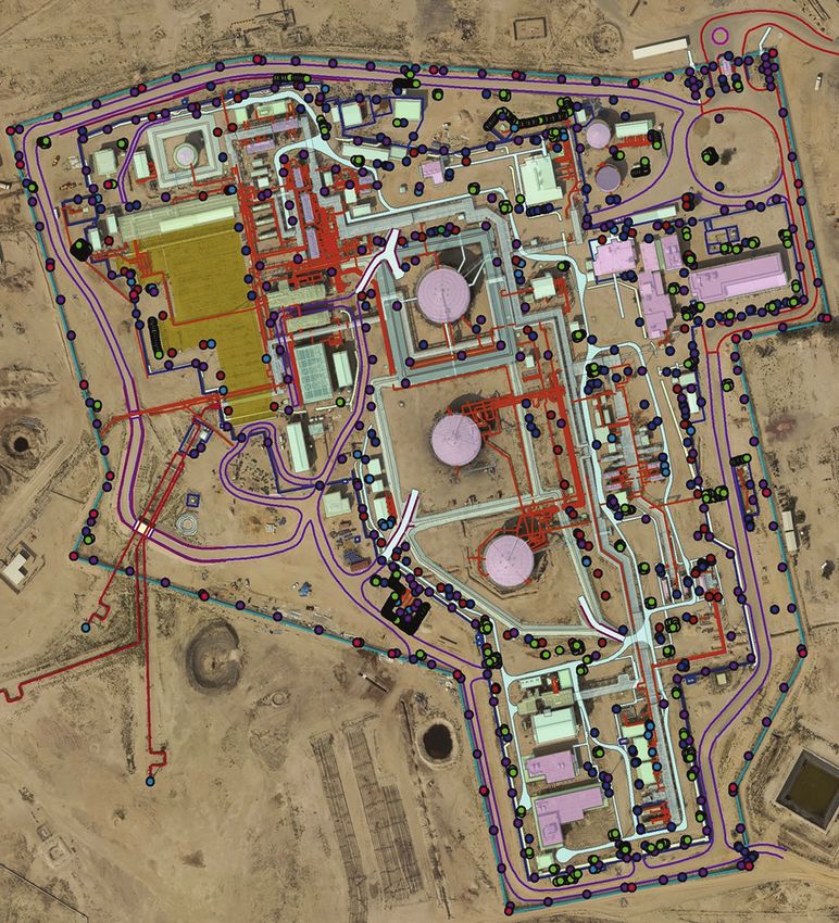
Introduction
The Infrastructure Master Plan (IMP) section of the Operations Support
Group in Kuwait Oil Company (KOC) is responsible for developing a
Master Plan to manage all the oil field’s surface footprint. Recently,
KOC made an important decision that would impact the quality and
accuracy of the data used for planning, operations and Health Safety &
Environment (HSE) activities. In order to achieve the purpose of sup-
porting automation, coordination and management of the company’s
geographic information and resources, IMP completed its first ever,
aerial acquisition of high resolution digital images of 10 cm and LiDAR
(Light Detection and Ranging) of 4 ppm. Orthophotos and LiDAR bare-
earth Digital Elevation Model (DEM) will be produced at two different
resolutions (10cm) and (20cm) using cutting-edge technologies.
Project Approach Keeping above factors in mind, the choice of sensor was
the second step towards aerial data acquisition. Since the aim
Project planning involved numerous coincident activities.
was to acquire digital images and LiDAR data over the same
KOC selected the Area of Interest (AOI) based on the geo-
area, flying two sorties was impractical. Therefore, Leica
graphic distribution of KOC services/ facilities all over the
RCD 30 Digital Imagery Sensor integrated with Leica-70-HP-
State of Kuwait. KOC fully understands that the AOI in-
MPIA LiDAR platform with simultaneous collect facility
cludes some military areas and Kuwait international border
was selected. RCD30 is the first medium format, single head
lines that require special consideration. Coordination was
camera which collects perfectly co-registered 80 MP RGBN
exercised to obtain necessary permits from the Directorate
Delivered by multispectral
Ingenta imagery. Its innovative features and configura-
General of Civil Aviation, Ministry of Defense and Air Force.
IP: 5.10.31.210 On: Fri, tion
06 Aug 2021 support
16:12:09
flexibility photogrammetric and remote sensing
Distribution of ground control points
Copyright: (GCP) was
American planned
Society for Photogrammetry and Remote Sensing
applications, offering performance otherwise only available
and signalization was performed to support the accuracy
from large format airborne sensors. Leica-70-HP LiDAR sen-
requirements of the project.
sor has a unique, sophisticated, optical beam-splitting system
Aerial Data Acquisition that bifurcates the laser beam, resulting in an effective scan
rate of 500,000 points per second. This gives the ALS-70-HP
The option of using Unmanned Aerial System (UAS) over a
the ability to achieve the highest point density at a given
manned aircraft was first evaluated. Factors considered for
altitude of any system currently in the market, resulting in
the evaluation included:
exceptional acquisition efficiency (www.leica-geosystems.com).
1. Area of Interest: Spread over 8000² Km. It was not fea-
The contractor was entrusted to choose an aircraft that
sible to use a UAS.
could accommodate the sensor system, be able to fly steady
2. Security: The AOI is close to international borders and
and make tear-drop turns within short distances. Rockwell
includes vital defense installations and air bases, making
International 690A was an ideal choice for this. Pictures in
it impossible to fly a UAS over them.
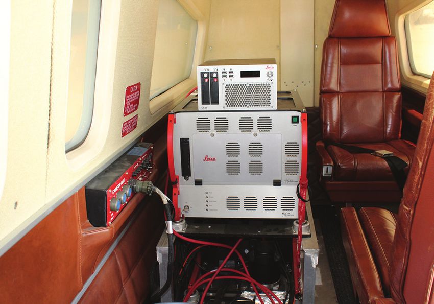
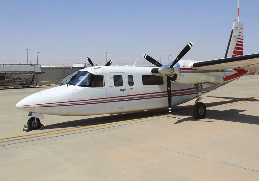
Figure 1 are of the aircraft and equipment used for acquisition.
3. Permissions: Obtaining permissions from Directorate
General of Civil Aviation (DGCA) to fly a UAS across half
the country is next to impossible.
Area of Interest
Aerial acquisition was planned at 10 cm resolution digital im-
4. Safety: If there were a failure in the UAS like disconnec-
ages and 4 points per square meter of LiDAR data for highly
tion of GPS lock or a mechanical failure, the UAS could go
developed areas, and 20 cm resolution digital images and 0.5
rogue and cause safety concerns to KOC assets or violate
points per square meter of LiDAR data for the other areas.
the geo-fence.
Area of interest towards North Kuwait had to be restricted to
5. Endurance: The endurance of a UAS is dependent on the
three (3) nautical miles from the Iraq International border.
weather, headwinds, etc. The maximum flight time for the
UAS could be about an hour making it difficult to com-
plete acquisition in one flying season. Photogrammetric Engineering & Remote Sensing
6. Payload: Although the scope included acquiring both Vol. 87, No. 5, May 2021, pp. 313–317.
aerial images and LiDAR data, getting a UAS to support 0099-1112/21/313–317
simultaneous collection was not possible. © 2021 American Society for Photogrammetry
and Remote Sensing
doi: 10.14358/PERS.87.5.313
314 M a y 2 0 21 PHOTOGRAMMETRIC ENGINEERING & REMOTE SENSING
05-21 May Feature Article V3 CMYK.indd 314 4/15/2021 12:52:43 PM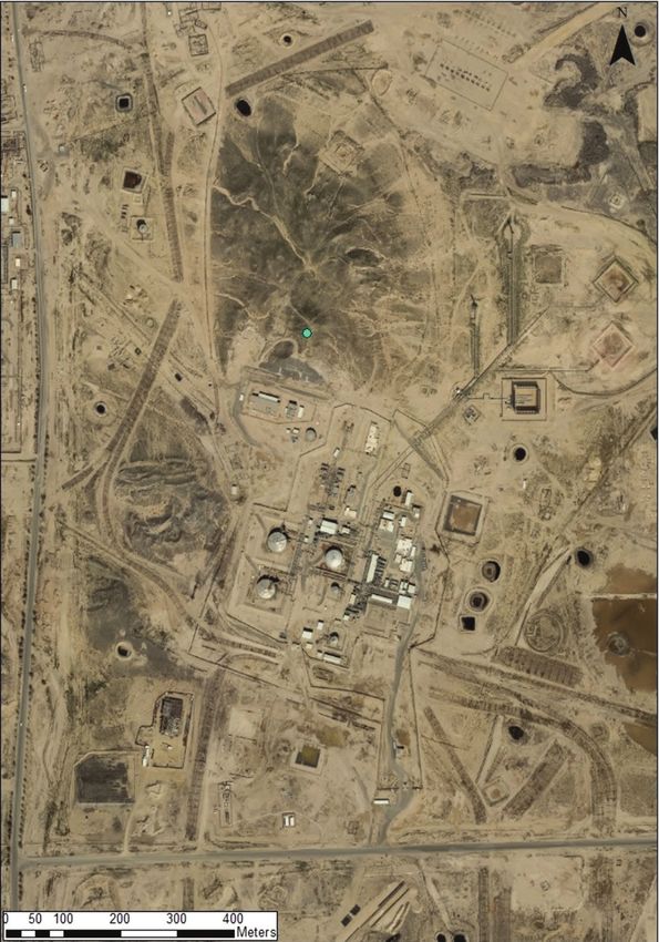
Challenges during Aerial Acquisition
The industry experts would agree that aerial acquisition,
though sounds easy, is quite a tedious task and influenced by
various external factors. The experience of IMP was no excep-
tion. Some of the challenges faced during acquisition and
mitigation steps taken were:
1. Weather: Kuwait experienced abrupt weather changes
during 2019. Although the acquisition was planned to
commence during the best season for aerial survey in
Kuwait, i.e. November to February, the planned 19 days
of acquisition actually took slightly over four (4) months
due to unexpected strong winds making it difficult to stick
to the planned flight path. Other challenges faced during (a)
acquisition were unexpected rains, haze, clouds, dust, and
fog. This was overcome by extending the schedule and
permissions assigned for aerial acquisition.
2. Smoke: Although the Production and Operations teams
were informed prior to aerial acquisition to keep the flar-
ing activity to minimum on the days of aerial photogra-
phy, it was not always feasible due to operation and pro-
duction constraints. Re-flights over the same areas were
performed to get images with minimum smoke around
production facilities.
3. Turbulence: One of the activities during production of
oil is to burn gases that usually accompany oil through a
smoke stack. This process is called as flaring. As part of (b)
production process, another activity is to burn out oil dur-
Figure 1. The aircraft – Rockwell International 690A (top)
ing asset maintenance. The air in the atmosphereDelivered
heats by Ingenta
IP: 5.10.31.210 On: Fri, 06 Augand the16:12:09
2021 Integrated Sensor System – Leica RCD 30 with
up around the flare stacks or burnAmerican
pits causing tempera-
Copyright: Society ALS70-HP
for Photogrammetry and(bottom).
Remote Sensing
ture and pressure variance. This makes the aircraft lose
altitude around these areas. The air-crew were prepared
well to control the aircraft around these areas, yet main-
tain the course and altitude manually. In order to main-
tain good quality data, the affected areas were re-flown.
4. Flying close to international borders: The area of inter-
est for aerial acquisition included areas close to interna-
tional borders that consist of crucial KOC assets. These
areas thus involved close coordination with the Aviation
and Defense authorities on both sides of the border and
due care was taken not to violate any aviation laws.
Experienced air crew were specially identified for the
process who carefully piloted the aircraft through tight
boundaries, yet covering a maximum AOI.
Image Data Processing
Data processing is a vital step for interpreting the results and
drawing meaningful conclusions. Digital Aerial Triangulation
(AT) was performed immediately upon the completion of
aerial acquisition. The purpose of AT is to densify horizontal
and vertical control from relatively few ground control points
(GCPs). Since obtaining GCPs is a relatively significant
expenses in any mapping project, AT procedures were used
to reduce the amount of field survey required by extending
control to all stereo models.
The surveyed control, along with the reduced image coor-
dinates, served as input into a combined block adjustment. Figure 2. Area of Interest covering South & East Kuwait
(SEK), North Kuwait (NK) and West Kuwait (WK) areas.
PHOTOGRAMMETRIC ENGINEERING & REMOTE SENSING M a y 2021 315
05-21 May Feature Article V3 CMYK.indd 315 4/15/2021 12:52:43 PM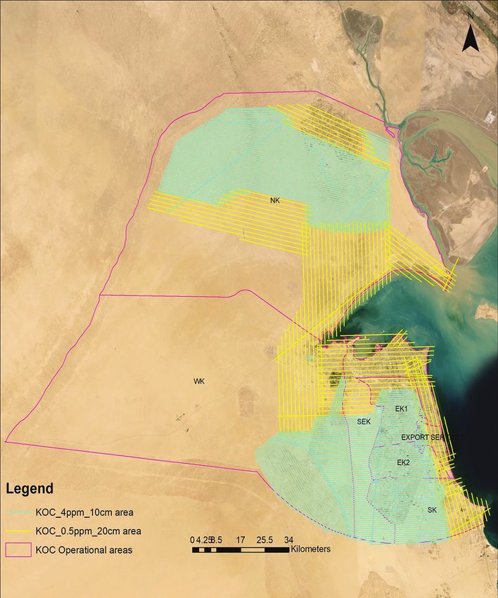
(a) (b)
Figure 3. 3D Data Compilation of a Gathering Center.
Three dimensional, simultaneous least squares adjustment
by bundles, commonly referred to as “bundle adjustment”,
Orthophoto Creation
Aerial images were ortho-rectified using the AT results and
was undertaken using Inpho Match-AT GPS adjustment Delivered by Ingenta
IP: 5.10.31.210 On: Fri, LiDAR
06 Aug DEM.
2021Color balancing and mosaicking were per-
16:12:09
software. A series of AT solutions were completed. The final
formed to ensure
Copyright: American Society for Photogrammetry andthe final imagery
Remote Sensing is both radiometrically
adjustment and the optimal solution to be used for mapping,
and geometrically seamless. The orthophotos were parti-
included all control points as constraints.
tioned and written out in compliance with the desired nam-
The AT results are being used for topographic data
ing convention in GeoTIFF and MrSID format. The resulting
compilation and creation of Digital Terrain Model (DTM) by
orthophoto tiles were seamless with no overlaps or gaps
compiling breaklines photogrammetrically.
between them.
LiDAR Data Processing On completion of data processing, KOC produced the
following outputs to support planning, operations and HSE
Post processing of all LiDAR data flight, strips were com-
activities:
pleted to perform calibration and verify quality and coverage.
1. Digital Orthophotos: Images that are rectified to accurate-
In order to ensure a homogenous surface, adjustments were
ly represent the ground and could be used as photo maps.
made to the orientation and/or linear deviation of individual
2. Bare Earth DEM: Accurate representation of ground fea-
and overlapping swaths to obtain the best fit relative accu-
tures or hypsography which could be used for generating
racy. Project-wide calibration was evaluated using advanced
contours depicting slopes.
vector matching analysis; and trajectory based solutions were
3. 3-dimensional Vector Maps: Compiled photogrammetri-
applied. This procedure was repeated interactively until the
cally to represent the above ground features such as
residual errors of overlapping swatch was reduced. A visual
buildings, pipelines, utilities, etc., in 3 dimensions (X, Y,
and statistical analysis was completed using elevation differ-
Z) accurately.
ence intensity raster and vector based accuracy reporting.
4. Digital Terrain Model: Created by adding supplementary
LiDAR data was then filtered and classified to separate
breaklines to the LiDAR DEM, where necessary to depict
terrain data from other data on land cover and manmade fea-
the sudden changes in slopes. The above derivatives shall
tures. Only a ground/non-ground classification was performed
be tested based on the industry accepted accuracy stan-
for this project. A variety of commercial and proprietary soft-
dards set by the American Society for Photogrammetry
ware were used to build macros for automated classification.
and Remote Sensing (ASPRS), ASPRS Positional
The macros were specific for the landscape of the project tak-
Accuracy Standards for Digital Geospatial Data (Edition
ing into consideration terrain relief, ground cover and natural
1, version 1.0. – November, 2014).
elevation and the numeric value of the returns.
316 M a y 2 0 21 PHOTOGRAMMETRIC ENGINEERING & REMOTE SENSING
05-21 May Feature Article V3 CMYK.indd 316 4/15/2021 12:52:43 PM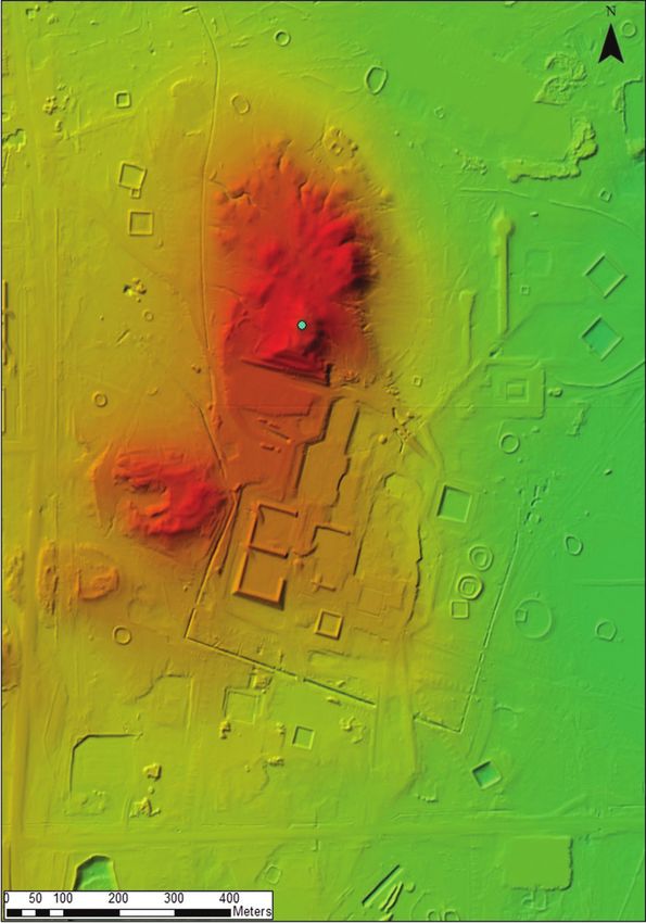
Quality Assurance and Quality Control
QA/QC is a process used to ensure the highest probability of cre-
ating quality products to predefined standards. KOC prepared
a detailed measurable Acceptance Criteria to guide the produc-
tion activities. It provides the basis for developing the support-
ing necessary tools to check the final deliverables and to confirm
the all the delivered products have passed the established listed
Acceptance Criteria. This includes in-house developed scripts to
automate the checking (file naming convention, format, projec-
tion parameters etc.) as well as visual checks to confirm the
adherence of the data to the predefined acceptance criteria.
Statistical and testing accuracy assessment has been
implemented to verify conformance with accuracy require-
ments of the project. The positional accuracy is calculated
statistically from well-known Ground Control and resulted in
10 cm for 10 cm orthophotos and 20 cm for that of 20 cm.
Conclusion
The anticipated challenges creating setbacks to the project
as mentioned earlier were used to create and update the risk
register and lessons learnt for future projects.
1. Although, using the imaging and LiDAR sensors for
simultaneous data collection reduced the collection time,
mobilizing two sets of aircraft and equipment would make
the collection process faster, resulting in faster data out-
put. Also, the re-flights of some areas could be avoided. It
is understood that the process would be expensive, but the
Figure 4. LiDAR generated terrain model after point
Delivered by Ingenta
benefits reaped in getting the data faster far outweighs
classification. IP: 5.10.31.210 On: Fri, 06 Aug 2021 16:12:09
the costs incurred.
Copyright: American Society for Photogrammetry and Remote Sensing
2. KOC field assets changes continuously. The data thus col-
lected could be processed much faster resulting in usable
information available to the field teams at a faster pace.
3. Periodic updates need be performed so that the informa-
tion available to the field teams are up-to-date.
The initiative of KOC in creating high resolution orthophoto
maps, LiDAR DEM, DTM and 3-D topographic maps shall
yield the following benefits to the company:
1. Creation of orthophotos to serve as a base map supports
in daily planning, operations and HSE functions. The
challenges faced by the field survey team in day-to-day op-
erations, such as route planning in terms of safest route,
and avoiding hazardous areas, etc. are eliminated.
2. Visual reference for infrastructure planning provides a
suitable platform to study the impact of KOC operations.
One of the main functions of IMP is effective land man-
agement. With the use of high resolution orthophotos and
LiDAR DEM, activities such as pipelines routes, land res-
ervation, asset demarcation, removal of abandoned assets,
etc. have become efficient.
3. Enhanced data collection in inaccessible and geo-hazard
areas through 3D compilation.
4. Producing LiDAR data (Elevation Data, Terrain Datasets)
to support:
a. Orthophoto rectification.
b. 3D simulations and spatial analysis.
Figure 5. Ortho-image at a resolution of 10 cm. c. Hydrological modeling.
d. Better representation of the terrain.
PHOTOGRAMMETRIC ENGINEERING & REMOTE SENSING M a y 2021 317
05-21 May Feature Article V3 CMYK.indd 317 4/15/2021 12:52:43 PM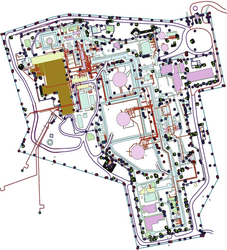
You can also read