May 2021 Tennessee State Climate Summary
←
→
Page content transcription
If your browser does not render page correctly, please read the page content below

May 2021 Tennessee State Climate Summary

          May 2021 Tennessee State Climate Summary
                       Tennessee Climate Office * East Tennessee State University
                          Prepared by William Tollefson and Dr. Andrew Joyner
                   With contributions by Climate Data Representatives across the state

Monthly Temperature Summary:
May 2021 averaged cooler than normal across most areas of the state, with a majority of Tennessee
reporting temperatures 1-4°F below normal. The middle of the month (May 10-16) brought some of the
coolest conditions with mean temperatures for that 7-day period 8-10°F below normal and low
temperatures dipping into the low 40’s and even 30’s for many locations. The Jackson Airport set daily
record low temperatures on May 15 (40°F) and May 16 (42°F). While temperatures stayed near or below
normal for most of the month, a brief heat wave brought high temperatures into the upper 80’s and low
90’s across the state from May 25-27. During this heat event, the Tri-Cities airport set a daily record high
for May 25 (90°F). Cooler than normal conditions returned at the end of the month, over Memorial Day
weekend, with record-low daily high temperatures set on May 30 at the Memphis (61°F) and Jackson
(62°F) airports.

                                                                                                          1
May 2021 Tennessee State Climate Summary

Monthly Precipitation Summary:
May 2021 was drier than normal for most areas of the state, but heavy rains associated with
thunderstorms in the first week of the month and widespread rains in the last week of the month resulted
in a few areas with above normal precipitation for May. East Tennessee was generally the driest part of
the state with a large portion of the region recording less than 75% of the normal monthly precipitation
totals for May. The Smoky Mountains and nearby foothills were an exception, with portions of Blount and
Sevier counties recording more than 125% of their normal monthly precipitation. Several rounds of severe
thunderstorms trained over areas in West and Middle Tennessee in the first week of the month, producing
heavy rainfall totals (of up to 5 inches in some areas). These areas recorded above normal precipitation
for the month.

                                                                                                      2
May 2021 Tennessee State Climate Summary

Station Data and Top Tenn. (warmest/wettest, coldest/driest stations of the month):
Station data for airports across the state using WBAN weather stations, compared to 1991-2020 climate
normals:
                                       Temperatures (˚F)                                 Precipitation (inches)
 Station Name             Averages                           Extremes                              Totals
                Max    Min      Mean    Depart   High      Date      Low     Date      Obs         Depart   %Norm
   Memphis      78.6   60.4     69.5     -2.6     89       5/27      49       5/7      4.01        -1.26     76%
   Jackson      76.6   54.2     65.4     -3.5     88       5/25      40      5/14      5.47        -0.11     98%
  Clarksville   75.6   53.3     64.5     -2.8     89       5/25      40      5/14      3.85        -1.05     79%
   Nashville    78.0   55.4     66.7     -2.6     93       5/25      42      5/14      5.05        0.03     101%
 Chattanooga    80.3   57.6     68.9     -1.1     93       5/25      47      5/14      2.62        -1.32     66%
   Crossville   71.7   50.3     61.0     -2.2     84       5/25      40      5/13      3.25        -1.93     63%
   Knoxville    76.9   55.0     65.9     -2.0     90       5/26      41      5/13      3.62        -0.51     88%
   Bristol      76.3 50.5    63.4     -1.3     90     5/25    36    5/13      2.24     -1.58     59%
Departures and %Norm Key: Warmer than Normal, Cooler than Normal; Wetter than Normal, Drier than Normal
                          Hottest Stations (highest maximum temperature)
                                                                             Highest
                                                           Station
                              Station Name                                 Temperature    Date
                                                            Type
                                                                               (F)
                               LYNCHBURG                    COOP               93             26
                       NASHVILLE BERRY FIELD                COOP               93             26
                         CHATTANOOGA AP                     WBAN               93             25
                         NASHVILLE INTL AP                  WBAN               93             25
                        LEWISBURG EXP STA                   COOP               92             26
                        WOODBURY 1 WNW                      COOP               92             26
                               SEVIERVILLE                  COOP               92             26
                               GLADEVILLE                   COOP               92             25
                              DECATUR 7NE                   COOP               92             26
                       SHILOH NMP TENNESSEE                 RAWS               92             24
                              MEMPHIS WFO                   WBAN               92             28
                          OAK RIDGE ASOS                     WBAN             92              25
                          Eight stations tied for the 5th hottest temperature (92°F)

                                                                                                                    3
May 2021 Tennessee State Climate Summary

                          Coldest Stations (lowest minimum temperature)
                                                      Station       Lowest
                           Station Name                                             Date
                                                       Type      Temperature (F)
                           MT LECONTE                  COOP           23             8
                          SMITHVILLE 2 SE              COOP             27          13
                          WAYNESBORO                   COOP             30          17
                       ROAN MOUNTAIN 3SW               COOP             30          13
                     PORTLAND SEWAGE PLANT             COOP             32          14
                        PICKETT STATE PARK             COOP             33           1
                            ERWIN 1 W                  COOP             34          16
                             TAZEWELL                  COOP             34          14
                         NEWFOUND GAP                  COOP             34           8
                       GREENEVILLE EXP STA             COOP             35          13
                              ONEIDA                   COOP             35          13
                            NEWCOMB                    COOP             35          14
                          MAYNARDVILLE                 COOP             35          13
                       CHEROKEE TENNESSEE              RAWS             35          13
                 CROSSVILLE AREA OFFICE TENNESS        RAWS            35           13
                                                   th
                           Six stations tied for 10 coldest temperature (35°F).

                           Warmest Stations (highest mean temperatures)
                                                                      Mean Temperature
                           Station Name               Station Type
                                                                             (F)
                    MEMPHIS INTERNATIONAL AP             WBAN               69.5
                         CHATTANOOGA AP                  WBAN                68.9
                          MEMPHIS WFO                    WBAN                68.1
                         SAVANNAH 6 SW                   COOP                67.6
                        GERMANTOWN 4SE                   COOP                67.5
                      SHILOH NMP TENNESSEE               RAWS                67.5
                           BROWNSVILLE                   COOP                67.2
                           HOHENWALD                     COOP                67.1
                        DYERSBURG III GOLF               WBAN                 67
                         NASHVILLE INTL AP               WBAN                66.7

                                                                                           4
May 2021 Tennessee State Climate Summary

                            Coolest Stations (lowest mean temperatures)
                                                                    Mean Temperature
                           Station Name             Station Type
                                                                           (F)
                            MT LECONTE                  COOP              45.4
                          NEWFOUND GAP                  COOP              53.8
                       ROAN MOUNTAIN 3SW                COOP              56.9
                        PICKETT STATE PARK              COOP              58.8
                       CHEROKEE TENNESSEE              RAWS               59.1
                        CROSSVILLE EXP STN              COOP              59.4
                     PORTLAND SEWAGE PLANT              COOP              59.4
                         CROSSVILLE 7 NW               WBAN               59.9
                             TAZEWELL                   COOP              60.1
                              ONEIDA                    COOP              60.1

                           Wettest Stations (highest precipitation totals):
                                                                    Total Precipitation
                            Station Name             Station Type
                                                                            (in)
                             MONTEREY                    COOP              7.97
                            MT LECONTE                   COOP                 7.9
                   MOUSETAIL LANDING STATE PARK          COOP                 7.85
                  FAIRVIEW BOWIE NATURE CENTER           COOP                 7.16
                              SELMER                     COOP                 7.04
                       LIVINGSTON RADIO WLIV             COOP                 7.03
                           FINGER 4.1 ENE             CoCoRaHS                6.63
                           WAYNESBORO                    COOP                 6.55
                        BYRDSTOWN 2.8 SSW             CoCoRaHS                6.35
                          NEWFOUND GAP                   COOP                 6.35

                             Driest Stations (lowest precipitation totals):
                                                                    Total Precipitation
                            Station Name             Station Type
                                                                            (in)
                           MAYNARDVILLE                  COOP              1.83
                        MAYNARDVILLE 0.6 E            CoCoRaHS                1.87
                             BRISTOL AP                 WBAN                  2.24
                           ELIZABETHTON                  COOP                 2.36
                             KINGSPORT                   COOP                 2.44
                              PIKEVILLE                  COOP                 2.49
                         CHATTANOOGA AP                 WBAN                  2.62
                            LYNCHBURG                    COOP                 2.66
                             ERWIN 1 W                   COOP                 2.69
                         BAILEYTON 1.0 NW             CoCoRaHS                2.73

                                                                                          5
May 2021 Tennessee State Climate Summary

The Month in Comparison:
Comparing the average temperature and total precipitation for May 2021 to the values for May over the
past thirty years, the cooler than average temperature pattern is visible. Jackson was a standout, with
2021 being the second coolest May of the past thirty years for that city. Each location besides Jackson and
Nashville also recorded less precipitation in 2021 than the average for the last thirty years, but it was not
one of the top-five driest Mays in the period for any city.

                                                                                                           6
May 2021 Tennessee State Climate Summary

                                           7
May 2021 Tennessee State Climate Summary

                                           8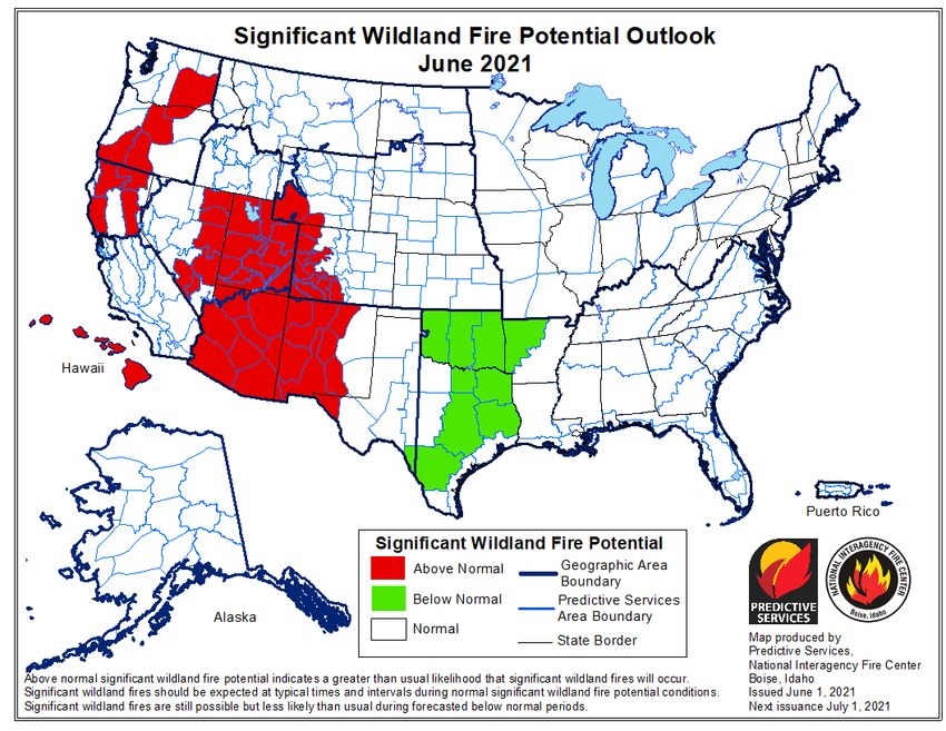
May 2021 Tennessee State Climate Summary

Drought Monitor:
Due to the drying trend observed over the past two months, outside of localized flooding rains from
thunderstorms, some small areas of D0 (Abnormally Dry) conditions were introduced to Tennessee in the
May 25 release of the U.S. Drought Monitor. These areas were centered around northeast Tennessee, the
northern Cumberland Plateau and southwest portions of Middle Tennessee, and total to 7.91% of the
state.

                                                                                                   9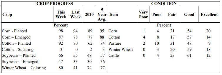
May 2021 Tennessee State Climate Summary

Soil Moisture:
Soil moisture averaged over 500mm, which was in the near-normal range for the month across the state.
However, there was a lowering of soil moisture levels over northern portions of the state, with the
northeast corner seeing the largest drop, around a 30mm decrease. The USDA Crop Weather Report for
the week ending May 30th indicated that topsoil moisture was 5% very short, 21% short, 60% adequate
and 14% surplus, while subsoil moisture was 2% very short, 18% short, 71% adequate and 9% surplus.

                                                                                                  10
May 2021 Tennessee State Climate Summary
11May 2021 Tennessee State Climate Summary
Streamflow:
Heavy rains in the first week of the month and in the last days of the month produced monthly mean
streamflow that was in the normal or above normal range compared to historical flow rates in May across
the state. Northeast Tennessee proved the exception where several stream gauges averaged below
normal streamflow for the month.
12May 2021 Tennessee State Climate Summary
Miscellaneous:
Crop Conditions from USDA: Heavy rains in West and Middle Tennessee at the beginning of May were a
hindrance to planting and hay harvests. Drier than normal conditions for the latter parts of the month
allowed for field work and hay harvests, but hay yields in Middle and East Tennessee were lower than
normal due to drier and cooler than normal conditions. By the end of the month corn, cotton, soybeans,
and winter wheat crops were all at or ahead of their 5-year average progress.
Fire Danger: The National Interagency Fire Center significant wildland fire potential outlook for June
shows all of Tennessee, along with the eastern third of the US, with normal chances for wildland fires in
the coming month.
13May 2021 Tennessee State Climate Summary
Snow: The Newfound Gap COOP weather station, in the Great Smoky Mountains National Park, reported
a trace of snow (less than 0.01”) on May 12. This was the only weather station that reported snow
accumulation during the month.
Story of the Month:
Severe storms occurring May 3-6 were the main story for May 2021, resulting in 15 tornadoes and 56
reports of severe wind damage. The NOAA Storm Prediction Center recorded a total of 19 tornadoes in
Tennessee during May, which is more than half of the annual average number of tornadoes that
Tennessee recorded from 1995-2020! Tennessee has averaged 30 tornadoes per year in the 1995-2020
time period, but 2021 has produced 33 tornadoes so far across the state. The annual number of tornadoes
from 1995-2020 is quite variable in Tennessee and ranges from as few as 9 in 2007 to 110 in 2011. Luckily
all of the tornadoes recorded in May of 2021 were rated EF0 (the weakest category on the Enhanced Fujita
scale for tornado strength), and there have been no fatalities caused by the tornadoes this year. However,
severe thunderstorm winds did result in two fatalities, both caused by falling trees, in the first week of
May.
For more statistics on Tennessee Tornadoes, visit the Nashville National Weather Service Office’s tornado
statistics webpage. (https://www.weather.gov/ohx/tntornadostats)
14May 2021 Tennessee State Climate Summary
Storm Reports:
*Storm Reports are based on filtered NOAA Storm Prediction Center data or local NWS storm reports. Future quality
control checks may change the official record of severe events, please see spc.noaa.gov for any updates.
There were five days in May with severe weather reports, resulting in a total of 19 tornadoes, 77 reports
of severe wind damage, and 3 reports of hail 1-inch or larger in diameter. There were two fatalities and
three injuries caused by the severe wind events this month.
May 3:
Tornadoes:
Time
Strength Location County Lat Lon Comments
(UTC)
A BRIEF EF-0 TORNADO TOUCHED
DOWN ALONG BOYNTON VALLEY
ROAD IN THE FREDONIA
6 NNW
16:42 EF0 COFFEE 35.55 -86.13 COMMUNITY AND MOVED
MANCHESTER
NORTHEAST... BLOWING DOWN
NUMEROUS TREES IN A STRONGLY
CONVERGENT PATTER (OHX)
AN EF-0 TORNADO TOUCHED DOWN
NEAR COTTON HARRIS ROAD
ALONG THE CHEATHAM/DAVIDSON
10:52 EF0 4 NW JOELTON CHEATHAM 36.35 -86.92 COUNTY LINE AND MOVED
EASTWARD ACROSS NORTHERN
PORTIONS OF JOELTON BLOWING
DOWN SCATTER (OHX)
THIS SMALL EF-0 TORNADO
TOUCHED DOWN NORTH OF
LAKEVIEW ROAD AND MOVED
5 NNE
10:56 EF0 ROBERTSON 36.56 -86.83 EASTWARD ACROSS CALVERT
SPRINGFIELD
ROAD... HEAVILY DAMAGING AN
OUTBUILDING... BLOWING MUCH
OF THE ROOF OFF A (OHX)
15May 2021 Tennessee State Climate Summary
Time
Strength Location County Lat Lon Comments
(UTC)
AN EF-0 TORNADO TOUCHED DOWN
NORTH OF MORTON ROAD TO THE
NORTHEAST OF GREENBRIER AND
3 NNE
11:01 EF0 ROBERTSON 36.47 -86.78 MOVED EASTWARD. NUMEROUS
GREENBRIER
TREES WERE BLOWN DOWN... AN
OUTDOOR SHED WAS DESTROYED...
(OHX)
THIS EF-0 TORNADO BEGAN ALONG
HENRY RD SOUTHWEST OF ORLINDA
5 WNW CROSS AND MOVED EAST BLOWING DOWN
11:02 EF0 ROBERTSON 36.57 -86.76
PLAINS SEVERAL TREES. MORE TREES WERE
SNAPPED AND UPROOTED ALONG
DOSS RD WITH ONE TREE (OHX)
AN EF-0 TORNADO TOUCHED DOWN
ALONG GREER ROAD NORTHWEST
OF GOODLETTSVILLE AND MOVED
11:03 EF0 4 SSW RIDGETOP DAVIDSON 36.35 -86.79 EASTWARD... BLOWING DOWN
DOZENS OF TREES... POWER LINES
AND SOME POWER POLES AS IT M
(OHX)
A SMALL... BRIEF AND WEAK EF-0
TORNADO TOUCHED DOWN IN
WHITE HOUSE ALONG HIGHWAY 76
11:10 EF0 WHITE HOUSE SUMNER 36.47 -86.66 THEN MOVED NORTHEAST ACROSS
HIGHWAY 31W AT PORTLAND ROAD
BEFORE LIFTING NEAR REIDWAY
(OHX)
THIS EF-0 TORNADO TOUCHED
DOWN ALONG SAUNDERSVILLE
ROAD NORTH OF COUNTRY HILLS
5 NNE
11:21 EF0 SUMNER 36.35 -86.56 GOLF COURSE... SNAPPING POWER
HENDERSONVILLE
POLES AND UPROOTING TREES. THE
TORNADO INTERMITTENTLY TOUCH
(OHX)
THIS EF-0 TORNADO BEGAN ON THE
SOUTHEAST SIDE OF GALLATIN
NEAR COLES FERRY ROAD AND
11:31 EF0 3 SE GALLATIN SUMNER 36.36 -86.42 MOVED EASTWARD... BLOWING
DOWN NUMEROUS TREES ON
STEAM PLANT ROAD... NEWTON
LANE... (OHX)
AN EF-0 TORNADO TOUCHED DOWN
ALONG ROCK SPRINGS ROAD SOUTH
OF CHENAULT LANE... HEAVILY
2 N CASTALIAN
11:38 EF0 SUMNER 36.42 -86.31 DAMAGING A BARN AND BLOWING
SPRINGS
DOWN NUMEROUS TREES. THE
TORNADO THEN MOVED EAST ACRO
(OHX)
16May 2021 Tennessee State Climate Summary
Time
Strength Location County Lat Lon Comments
(UTC)
AN EF-0 TORNADO TOUCHED DOWN
JUST WEST OF THE CATO
COMMUNITY AND MOVED
11:54 EF0 2 E HARTSVILLE TROUSDALE 36.39 -86.12 SOUTHEAST... DAMAGING A
BUSINESS AT HIGHWAY 10 AND
FORT BLOUNT ROAD. THE TORNADO
CONTINUED THROUG (OHX)
THIS SMALL... WEAK TORNADO
TOUCHED DOWN ON
BRATTOWNTOWN CIRCLE ON THE
1 WNW
11:56 -- MACON 36.53 -86.05 WEST SIDE OF LAFAYETTE AND
LAFAYETTE
MOVED SOUTHEAST... KNOCKING
DOWN SEVERAL TREES AND
PARTIALLY BLOWING TH (OHX)
Wind:
Time Speed
Location County Lat Lon Comments
(UTC) (mph)
4 SW COUPLE TREES DOWN ALONG
18:25 -- GREENE 36.12 -82.87
GREENEVILLE WARRENSBURG ROAD. (MRX)
8:05 -- TIPTONVILLE LAKE 36.38 -89.47 POWER POLE SNAPPED. (MEG)
WIDESPREAD TREE AND ROOF
8:15 -- SAMBURG OBION 36.38 -89.35 DAMAGE IN THE SAMBURG AREA.
(MEG)
TREES AND POWER LINES DOWN
8:30 -- 2 NE UNION CITY OBION 36.45 -89.02 ALONG US 51 AT BETHLEHEM RD.
ROAD CURRENTLY CLOSED. (MEG)
TREES AND POWERLINES DOWN AT
8:40 -- 4 NNW KENTON OBION 36.25 -89.04 HIGHWAY 45 AND EAST UNION GROVE
RD. (MEG)
8:47 60 5 W SHARON WEAKLEY 36.24 -88.91 (MEG)
*** 1 FATAL *** MOBILE HOME FELL
8:49 -- 2 SW DRESDEN WEAKLEY 36.26 -88.71 ON A MOBILE HOME. DELAYED
REPORT. (MEG)
TREES AND POWERLINES DOWN.
9:20 -- PARIS HENRY 36.3 -88.31
(MEG)
MOBILE HOME OVERTURNED AT
7 NNE BIG STOCKDALE CIRCLE AND LICK CREEK
9:30 -- BENTON 36.32 -88.02
SANDY RD. NUMEROUS TREES DOWN AND
POWER OUTAGES IN THE AREA. (MEG)
6 NNE TREE DOWN ON DILLAHUNTY RD.
9:40 -- CARROLL 36.08 -88.38
HUNTINGDON (MEG)
NUMEROUS TREES DOWN AND
9:47 -- DOVER STEWART 36.48 -87.84 POWER OUTAGES ACROSS STEWART
COUNTY (OHX)
TREES AND POWER LINES DOWN ON
10:15 -- 5 NNW PARSONS DECATUR 35.72 -88.17 EVANSTOWN RD NORTH OF PARSONS.
(MEG)
A SWATH OF TREES WAS SNAPPED
10:19 -- 7 NE SLAYDEN MONTGOMERY 36.35 -87.38
AND UPROOTED NEAR THE
17May 2021 Tennessee State Climate Summary
Time Speed
Location County Lat Lon Comments
(UTC) (mph)
INTERSECTION OF HIGHWAY 48 AND
GRAYS CHAPEL ROAD (OHX)
11 SE SEVERAL TREES WERE BLOWN DOWN
10:30 -- MONTGOMERY 36.45 -87.21
CLARKSVILLE AT 3567 TANNAHILL COURT (OHX)
NUMEROUS TREES DOWN AND
10:43 -- CEDAR HILL ROBERTSON 36.55 -87 POWER OUTAGES ACROSS ROBERTSON
COUNTY (OHX)
TSPOTTER REPORT OF A TREE
THROUGH A FENCE IN
11:07 -- GOODLETTSVILLE DAVIDSON 36.32 -86.71
GOODLETTSVILLE OFF OF LICKTON
PIKE. (OHX)
4" TREE SNAPPED MID TRUNK ON
1W
11:08 -- SUMNER 36.38 -86.73 WILLIAMSON RD NEAR MANSKER
MILLERSVILLE
CREEK (OHX)
THE ORLINDA TORNADO DISSIPATED
INTO A LARGE DOWNBURST THAT
4 WSW BLEW DOWN SEVERAL TREES IN
11:14 -- SUMNER 36.57 -86.59
PORTLAND NEIGHBORHOODS ALONG WEST
HARPER ROAD AND JERNIGAN ROAD...
WITH BOTH ROADWAYS BLOCK (OHX)
A COUPLE OF POWER POLES BLOWN
11:25 -- HAMPSHIRE MAURY 35.6 -87.29
DOWN NEAR HAMPSHIRE (OHX)
SW WHITE REPORT OF NUMEROUS TREES DOWN
11:27 -- ROBERTSON 36.46 -86.67
HOUSE IN ROBERTSON COUNTY. (OHX)
TREES DOWN IN PORTIONS OF
11:29 -- GALLATIN SUMNER 36.38 -86.45
GALLATIN (OHX)
ROOF DAMAGED ON MOBILE HOME
2 NW
11:30 -- LAWRENCE 35.45 -87.34 AT 348 HIGHWAY 20 AND TREES
SUMMERTOWN
DOWN IN AREA (OHX)
TSPOTTER REPORT OF A TREE
THROUGH A FENCE IN
11:32 -- GOODLETTSVILLE DAVIDSON 36.32 -86.71
GOODLETTSVILLE OFF OF LICKTON
PIKE. (OHX)
4" TREE SNAPPED MID TRUCK ON
1W
11:33 -- SUMNER 36.38 -86.73 WILLIASMON RD. NEAR MANSKER
MILLERSVILLE
CREEK (OHX)
3 ENE REPORT OF SEVERAL TREES DOWN.
11:39 -- CASTALIAN TROUSDALE 36.42 -86.27 FRONT PORCH OVERHANG COLLAPSED
SPRINGS ALONG WITH COLUMNS (OHX)
TREES AND POWERLINES
11:53 -- LAFAYETTE MACON 36.52 -86.03 DOWN...SOME ROOFS DAMAGED AS
WELL (OHX)
FENCES AND A SCOREBOARD WERE
11:55 -- 4 SW LEBANON WILSON 36.17 -86.37 DAMAGED AT WILSON CENTRAL HIGH
SCHOOL. (OHX)
MULTIPLE TREES AND POWERLINES
DOWN...SOME RESIDENTIAL DAMAGE
11:55 -- HARTSVILLE TROUSDALE 36.39 -86.16 ON 231N...DAMAGE TO BARN ON
DAVENPORT LANE...MULTIPLE ROADS
BLOCKED (OHX)
18May 2021 Tennessee State Climate Summary
Hail:
Time Size
Location County Lat Lon Comments
(UTC) (in)
6:55 1.00 8 E CELINA CLAY 36.53 -85.36 (OHX)
CROCKET QUARTER SIZE HAIL FELL FOR 5
9:20 1.00 GADSDEN 35.78 -88.98
T MINUTES. (MEG)
2 SSE
10:15 1.00 BLOUNT 35.69 -83.8 (MRX)
WALLAND
May 4:
Tornadoes:
Time
Strength Location County Lat Lon Comments
(UTC)
THIS SMALL... BRIEF TORNADO TOUCHED
DOWN ON THE SOUTH SIDE OF ALEXANDRIA.
1S
12:20 -- DE KALB 36.06 -86.03 SECURITY VIDEO CAMERAS AT A HOME ON
ALEXANDRIA
OLD LIBERTY ROAD CAPTURED THE TORNADO
AS THE ROOF AND BACK (OHX)
THIS EF-0 TORNADO TOUCHED DOWN ALONG
COCONUT RIDGE ROAD NORTH OF
3 NNE
12:43 EF0 DE KALB 36 -85.8 SMITHVILLE... BLOWING DOWN SEVERAL
SMITHVILLE
TREES. MOVING SOUTHEAST... THE TORNADO
CROSSED HIGHWAY 56 AND MOVED (OHX)
THIS SMALL EF-0 TORNADO TOUCHED DOWN
ON THE NORTH SIDE OF SPARTA NEAR
3 NNW
13:07 EF0 WHITE 35.97 -85.49 FRANKLIN AVENUE AND SPRING STREET.
SPARTA
MOVING SOUTHEAST... THE TORNADO
HEAVILY DAMAGED A BARN ON ROBER (OHX)
Wind:
Time
Speed Location County Lat Lon Comments
(UTC)
SEVERAL TREES WERE BLOWN DOWN
3 N CHAPEL
12:04 -- MARSHALL 35.67 -86.69 AROUND 3 HOMES AT 5765 NASHVILLE
HILL
HIGHWAY (OHX)
POWER POLES SNAPPED IN HALF ALONG
12:10 -- MILLERSVILLE SUMNER 36.38 -86.7
WITH 12 TO 18 INCH TREES SNAPPED
19May 2021 Tennessee State Climate Summary
Time
Speed Location County Lat Lon Comments
(UTC)
ALONG 41 BETWEEN 31W SPLIT AND
WILLAMSON. LINES DOWN AND TREES
DOWN. (OHX)
LARGE METAL BARN DESTROYED AND
12:19 -- 6 ESE ROVER BEDFORD 35.64 -86.49 GRAIN BIN PUSHED OFF FOUNDATION ON
MANKIN ROAD (OHX)
4 NE TREE DOWN ACROSS ROAD NEAR SHORT
12:45 -- CANNON 35.87 -86.02
WOODBURY MOUNTAIN IN NE CANNON CO (OHX)
TREES DOWN AND SOME STRUCTURAL
DAMAGE OF HOMES IN SMITHVILLE AND
12:45 -- SMITHVILLE DE KALB 35.96 -85.82
ALSO TOWARD FLAGO BRIDGE IN THE
HOLLIDAY HAVEN COMMUNITY (OHX)
TREE DOWN ALONG WINDLE COMMUNITY
12:47 -- LIVINGSTON OVERTON 36.39 -85.33
RD NEAR PUNCHEON CREEK (OHX)
SEVERE STRAIGHT-LINE WINDS CAUSED
SIGNIFICANT DAMAGE ON THE WEST SIDE
3 WNW OF SPARTA ALONG OLD SMITHVILLE
13:03 -- WHITE 35.95 -85.52
SPARTA HIGHWAY AND HIGHWAY 70. NUMEROUS
TREES WERE BLOWN DOWN... OUTBUILDI
(OHX)
3E NUMEROUS TREES WERE BLOWN DOWN
13:04 -- COFFEE 35.47 -86.02
MANCHESTER ALONG JONES VALLEY ROAD (OHX)
PLEASANT MULTIPLE TREES DOWN IN PLEASANT HILL
13:15 -- CUMBERLAND 35.98 -85.2
HILL (OHX)
DOZENS OF TREES WERE BLOWN DOWN
3 NNE
AROUND THE HEATHERHURST GOLF
13:30 -- FAIRFIELD CUMBERLAND 36.04 -84.88
COURSE WITH SOME TREES FALLING ONTO
GLADE
HOMES AND ACROSS ROADS. (OHX)
TREES DOWN ON SUMMERFIELD ROAD
2 W TRACY
13:38 -- GRUNDY 35.26 -85.8 AND NEAR SOUTH CUMBERLAND VISITORS
CITY
CENTER (OHX)
CORRECTS PREVIOUS TSTM WND DMG
3 SW REPORT FROM 3 W DEERLODGE. SEVERAL
13:45 -- MORGAN 36.2 -84.82
DEERLODGE TREES DOWN ON HWY 62 IN THE
CHESTNUT RIDGE COMMUNITY. (MRX)
13:50 -- PIKEVILLE BLEDSOE 35.61 -85.2 MULTIPLE HOMES DAMAGED. (MRX)
3 SSW OAK
14:10 -- ROANE 35.92 -84.33 COUPLE TREES DOWN. (MRX)
RIDGE
1 NNW
TREES DOWN ALONG THE FOOTHILLS
14:55 -- HAPPY BLOUNT 35.62 -83.96
PARKWAY. (MRX)
VALLEY
SEVERAL TREES DOWN IN THE SEVIERVILLE
15:00 -- SEVIERVILLE SEVIER 35.87 -83.57
AREA. (MRX)
20May 2021 Tennessee State Climate Summary
May 6:
Wind:
Time Speed Location County Lat Lon Comments
(UTC)
20:30 -- TRENTON GIBSON 35.97 -88.94 SEVERAL TREES DOWN... POWER LINES
DOWN ON US 45W BETWEEN TRENTON
AND HUMBOLDT (MEG)
21:15 -- TOONE HARDEMAN 35.35 -88.95 SEVERAL TREES DOWN IN TOONE.
(MEG)
21:21 -- GIBSON GIBSON 35.87 -88.85 MULTIPLE TREES ON HOUSES... POWER
LINES DOWN... TREE FELL ON A CAR
(MEG)
21:29 -- 2N MONTGOMERY 36.59 -87.35 FACEBOOK REPORT OF TREES DOWN AT
CLARKSVILLE SETTLEMENT DAYCARE. (OHX)
21:45 -- 2 ENE DICKSON DICKSON 36.08 -87.35 TREES DOWN OLD COLUMBIA ROAD
NEAR HIGHWAY 70. #TSPOTTER (OHX)
21:48 -- 3 W MCEWEN HUMPHREYS 36.11 -87.69 FACEBOOK REPORT OF TREES DOWN.
(OHX)
21:48 -- ADAMS ROBERTSON 36.58 -87.07 REPORTS OF TREESD DOWN ON OLD
WASHINGTON ROAD. (OHX)
21:52 -- PORT ROYAL MONTGOMERY 36.55 -87.14 RECEIVED A REPORT OF TREES DOWN
AND A GUST TO 76 MPH ON A
BACKYARD WEATHER STATION. (OHX)
21:56 -- 4S ROBERTSON 36.38 -86.98 *** 1 FATAL *** A LARGE TREE FELL ON
COOPERTOWN A MOTORCYCLIST AT SOUTH WALKER
RD AND MCMAHAN HOLLOW RD.
(OHX)
22:05 -- MICHIE MCNAIRY 35.06 -88.43 SEVERAL TREES DOWN (MEG)
22:08 -- SPRINGFIELD ROBERTSON 36.5 -86.88 TREES DOWN 200 BLOCK N MAIN
STREET. (OHX)
22:18 -- HOHENWALD LEWIS 35.55 -87.56 REPORTS OF TREES DOWN ON
WOODMERE DRIVE AND MULTIPLE
REPORTS OF STRONG WINDS ACROSS
THE AREA. (OHX)
22:21 -- SAVANNAH HARDIN 35.22 -88.24 *** 1 INJ *** 30-40 REPORTS OF TREES
DOWN... TREES ON HOUSES... POWER
LINES DOWN. (MEG)
21May 2021 Tennessee State Climate Summary
Time Speed Location County Lat Lon Comments
(UTC)
22:24 -- RIDGETOP ROBERTSON 36.39 -86.77 REPORT OF A TREE FELL ON A HOUSE
ON OBRYAN STREET. (OHX)
22:30 -- DONELSON DAVIDSON 36.16 -86.67 TREES DOWN NEAR THE YMCA ALONG
LEBANON RD (OHX)
22:36 -- ETHRIDGE LAWRENCE 35.32 -87.3 TREE DOWN ON HOUSE WITH PEOPLE
TRAPPED HIGHWAY 43. (OHX)
22:42 -- 3 SW MAURY 35.59 -87.09 LARGE TREE SNAPPED. (OHX)
COLUMBIA
22:42 -- FRANKLIN WILLIAMSON 35.93 -86.84 REPORT OF A TREE DOWN NEAR COOL
SPRINGS. (OHX)
22:48 -- 1 SW DAVIDSON 36.15 -86.68 LARGE LIMBS DOWN NEAR ELM HILL
DONELSON AND MCCOVOCK PIKE. #TSPOTTER
(OHX)
22:51 -- LYNNVILLE GILES 35.38 -87.01 REPORTS OF TREES DOWN ACROSS
COUNTY. PICTURE OF TREE DOWN IN
LYNNVILLE. (OHX)
22:54 -- LAFAYETTE MACON 36.52 -86.03 REPORT OF TREES AND POWERLINES
DOWN ON SPRING CREEK ROAD. (OHX)
23:12 -- SMYRNA RUTHERFORD 35.98 -86.52 REPORTS TREES DOWN AND SPLIT ON
SAM DAVIS ROAD. #TSPOTTER (OHX)
23:28 -- 5S LINCOLN 35.08 -86.58 PORTIONS OF A METAL ROOF WAS
FAYETTEVILLE PEELED OFF OF A HOME IN PARK CITY.
(HUN)
23:28 -- 2 SW BEDFORD 35.47 -86.47 A COUPLE TREES DOWN IN THE FLAT
SHELBYVILLE CREEK AREA. (OHX)
23:54 -- TULLAHOMA COFFEE 35.37 -86.22 REPORT OF LARGE TREES DOWN ON
DAVIS STREET. (OHX)
23:54 -- LAFAYETTE MACON 36.52 -86.03 REPORT OF TREES AND POWERLINS
DOWN ON SPRING CREEK ROAD. (OHX)
0:10 -- WINCHESTER FRANKLIN 35.19 -86.11 TREES DOWN THROUGHOUT
WINCHESTER. TIME ESTIMATED FROM
RADAR. (HUN)
0:35 -- SOUTH MARION 35.01 -85.71 A FEW TREES DOWN. (MRX)
PITTSBURG
1:10 -- 6 SW HAMILTON 35.01 -85.33 LARGE TREE FELL ON HOME AND
CHATTANOOGA TRAPPED RESIDENT INSIDE AT THE 4000
BLOCK OF ST ELMO AVE. NO INJURIES.
(MRX)
22May 2021 Tennessee State Climate Summary
May 9:
Tornadoes:
Time
Strength Location County Lat Lon Comments
(UTC)
WNW TORNADO SPOTTED ON CAMP GROUND
22:17 -- TIPTON 35.45 -89.77
ATOKA ROAD. (MEG)
A SMALL... BRIEF AND WEAK EF-0 TORNADO
TOUCHED DOWN ALONG MEEKS ROAD
3 SW
0:38 EF0 WILLIAMSON 35.84 -86.76 SOUTHWEST OF PAGE HIGH SCHOOL AND
ARRINGTON
MOVED NORTHEAST... PASSING JUST SOUTH
OF THE STAGS LEAP SUBDIVISI (OHX)
Wind:
Time
Speed Location County Lat Lon Comments
(UTC)
NUMEROUS TREES DOWN IN SHARPS CHAPEL
SHARPS
22:07 -- UNION 36.34 -83.81 AND ELSEWHERE IN UNION COUNTY. TDOT IS
CHAPEL
WORKING TO CLEAR BLOCKED ROADS. (MRX)
2 NW POWER LINES AND TREES DOWN AT RUGH
22:18 -- TIPTON 35.47 -89.83
MUNFORD ROAD AND PLANTATION RD. (MEG)
4 SW
A COUPLE OF TREES DOWN NEAR BRISCOE
22:20 -- BUFFALO GRAINGER 36.17 -83.61
ROAD... AND INDIAN RIDGE ROAD. (MRX)
SPRINGS
POWER LINES AND POSSIBLE TREES DOWN AT
23:02 -- MUNFORD TIPTON 35.45 -89.8
RUGH ROAD AND PLANTATION RD. (MEG)
TREES AND POSSIBLE POWER LINES DOWN
23:25 -- SALTILLO HARDIN 35.38 -88.21
ALONG HGWY 69 AND HANDY CORNER. (MEG)
A METAL COMMERCIAL SIGN WAS DAMAGED
6S
1:00 -- LINCOLN 35.07 -86.57 AT 2809 HUNTSVILLE HIGHWAY. TIME
FAYETTEVILLE
ESTIMATED BY RADAR. (HUN)
23May 2021 Tennessee State Climate Summary
May 28:
Tornadoes:
Time
Strength Location County Lat Lon Comments
(UTC)
AN EF-0 TORNADO TOUCHED DOWN NEAR
SOUTH WILLOW AVENUE AND WINSTON DRIVE
2 SW
17:57 EF0 PUTNAM 36.13 -85.53 IN COOKEVILLE CAUSING MINOR DAMAGE TO A
COOKEVILLE
CHURCH...MODERATE DAMAGE TO AN
OUTBUILDING AND SNAPPED L (OHX)
*** 2 INJ *** A BRIEF EF-0 TORNADO
TOUCHED DOWN SOUTH OF LIVINGSTON TO
4S
18:13 EF0 OVERTON 36.33 -85.33 THE WEST OF BILBREY ROAD. SECURITY
LIVINGSTON
CAMERA VIDEO FROM CLYDESDALE FARMS ON
DALE GUNNELS LANE SHOWED (OHX)
Wind:
Time Speed
Location County Lat Lon Comments
(UTC) (mph)
1E TREES DOWN ON WATAUGA DRIVE IN EAST
18:03 -- PUTNAM 36.16 -85.49
COOKEVILLE COOKEVILLE. (OHX)
3 WNW TREES DOWN IN THE AREA... AND SOME
20:11 -- ANDERSON 36.11 -84.18
CLINTON POWER OUTAGES. (MRX)
REPORT FROM MPING: 3-INCH TREE LIMBS
21:06 -- 1 N TALBOTT HAMBLEN 36.16 -83.42
BROKEN;. (MRX)
SPOTTER MEASURED 67MPH GUST.
21:10 67 2 NE ALPHA HAMBLEN 36.2 -83.36
NUMEROUS LARGE TREE LIMBS DOWN. (MRX)
REPORTS OF TREES DOWN AROUND HAMPTON.
22:50 -- HAMPTON CARTER 36.29 -82.17
(MRX)
24May 2021 Tennessee State Climate Summary
CPC Outlooks for the Next Month:
The NOAA Climate Prediction Center one-month outlooks for June indicate that all of Tennessee will have
equal chances of normal, warmer or cooler conditions in June, but will likely be wetter than normal, with
higher confidence along the southern border of the state.
25You can also read