MCGILLIVRAY PARK A MID-CENTURY MODERN WINNIPEG SUBDIVISION - RANDY ROSTECKI - WINNIPEG ARCHITECTURE FOUNDATION
←
→
Page content transcription
If your browser does not render page correctly, please read the page content below
McGILLIVRAY PARK
  A Mid-century Modern
  Winnipeg Subdivision

               Randy Rostecki
    For the City of Winnipeg Heritage Section of
       Planning, Property and Development

                       2013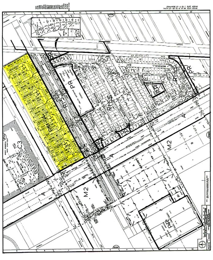
On the Cover:
Detail of Southview advertisement.
(Legislative Library of Manitoba)

Acknowledgement:
This report was developed with the support of the Heritage Grants Program of Manitoba
Culture, Heritage and Tourism.
PREFACE
This report has been developed with the guidance of the City of Winnipeg’s Heritage Section of the
Department of Planning, Property and Development, which has been working with the Province’s
Historic Resources Branch of Manitoba Culture, Heritage and Tourism to create various background
materials to address the subject of Manitoba Mid-century Modernist legacy.
Modern architecture was widely embraced in North America after World War II. Modernism was seen as
fresh, bold and forward-looking. These were key attributes that defined North American society after
World War II, and especially in the 1950s and 1960s. Modern architects were interested in addressing
new social and economic challenges through new buildings and designs, like low-income housing,
hospitals and factories. Manitoba was at the forefront in Canada in embracing Modernism. The School of
Architecture at the University of Manitoba was led by a renowned Modernist – John A. Russell, who had
connections to major eastern American design schools. Many U of M students went on to train with
Modernist masters like Mies van der Rohe, Walter Gropius, Eero Saarinen and Louis Kahn. Returning to
Manitoba these young architects found fertile ground for this new approach to building design, in
governments of the day, corporations, churches and the public at large.
This present research project began with the production of an inventory of Winnipeg’s Mid-century
Modern subdivisions, presented in Appendix 2. That inventory was then used to identify five subdivisions
that would be the subjects for this research project. The five subdivisions are:
Kiwanis Courts
McGillivray Park
Norwood Flats
Roblin Park
Silver Heights
The other four reports in this set are available from the City of Winnipeg’s Heritage Section of the
Department of Planning, Property and Development.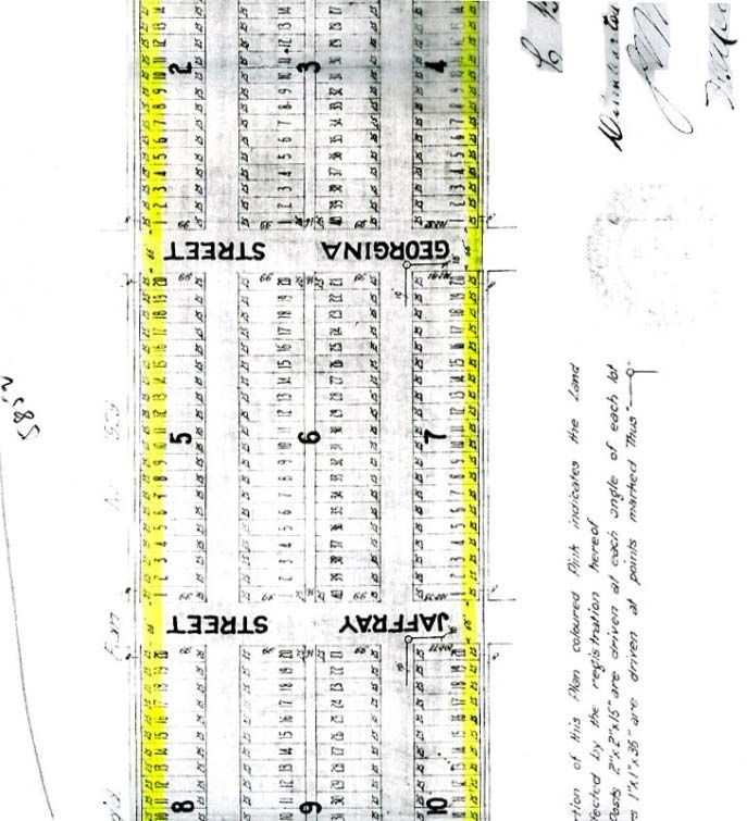
McGILLIVRAY PARK
A Mid-century Modern Winnipeg Subdivision
Fast Facts
Developer: C.T. Lount Construction Company (Principal Graham Lount)
Financing: Central Mortgage and Housing Corporation (CMHC)
Dates of Construction: 1954
Architects: Not identified through present research
Costs: $2.5 million
Number of houses: 240 units (60 quadraplex)
I
n the late 1940s and early 1950s, the Greater Winnipeg area faced a housing shortage which
was the result of nearly a decade of the Depression of the 1930s, followed by years of war.
The post-World War II housing boom began slowly at first, building momentum after 1950.
The nature of much of this new housing was middle-class, as that group of people were enjoying
a new-found prosperity. This was manifest in such subdivisions as Silver Heights and Lyndale
Park, while Roblin Park catered to returned veterans. Low-income earners appear to have been
considered initially low in the scheme of things, as many of them wound up in Winnipeg’s
profusion of rooming houses and early social housing projects such as Flora Place. The 1950s
would foster a number of low-cost rental projects such as the Kiwanis housing on Sinawik Bay
in St. James, or various Royal Canadian Legion complexes around Winnipeg. An ambitious
example was to arise on an area of industrially-zoned land in Fort Garry, on the south side of
McGillivray Boulevard, west of Pembina Highway. It would be called McGillivray Park (Plate
1).
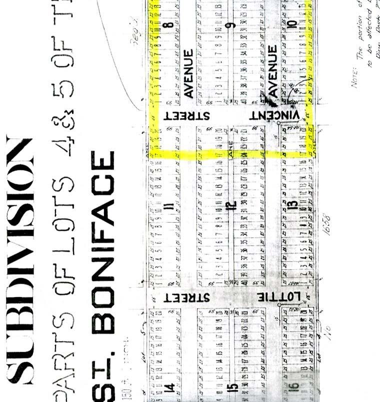
Prior to the creation of Plan 5852 (registered 28 April 1954) (Plate 2), which created the
McGillivray Park subdivision, that particular tract had had a long and somewhat convoluted
history. Like most of the property that fronted on the rivers in Winnipeg, Lots 4 and 5, Parish of
St. Boniface had been the farm lots of two Métis farmers as early as 1835. Both lots remained in
the ownership of Métis holders until the early twentieth century, when what was developing into
the Rural Municipality of Fort Garry began to attract the attention of speculators. The passage of
Pembina Highway had divided most of the river lots in this area on the west side of the Red
1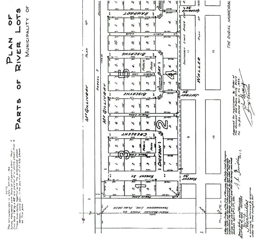
River. Similarly, the right-of-way of the Red River Valley Railway (later Northern Pacific and
Manitoba Railway, and now Canadian National Railways) in 1889-1890 further divided
properties such as 4 and 5 St. Boniface into attractive portions for speculators.1

By 1912, the area of 4/5 St. Boniface west of the CNR track, up to the Two Mile Road
(Waverley Street) was owned by two dairymen, Constant and Emerence Bossuyt. The Bossuyts
likely used their property for pasturage, though some change was on the horizon because of the
red-hot Winnipeg realty market at that time. They got together with a realtor, Skuli Hansson of
St. Vital Investments Limited, to foster a subdivision of their pasture lands. Hansson began
advertising the new residential subdivision—Southview—in April and May of 1912 (Plates 3
and 4). Surveyor Stephen Guttormsson surveyed the tract between 6 and 16 May 1912, carving
out the rights-of-way for two east-west thoroughfares—Willesden and Dumbarton avenues,
while extending a number of other north-south streets already in existence to the south of
Southview. It consisted of 31 blocks of mainly 25-foot-wide lots, with 843 supposedly highly-
saleable units in the works. Curiously, despite Hansson’s claims for rapid sales of Southview that
spring, Guttormsson’s plat of Southview was not registered until December 1913, as Plan 2203
(Plate 5, Parts A, B and C). By then, the Winnipeg realty boom had collapsed, though many
operators held out hopes for a speedy revival in 1914. Those hopes were dashed by the start of
World War I. By 1915, the area of what would become McGillivray Park—that is, Blocks 2/10
and portions of Blocks 1, 11-13—were owned by a speculative firm, Dumbarton Investments. By
1919, Constant Bossuyt took back the unsold property, cancelling Plan 2203 the following year
and presumably returning the cows to their pasture.2

Members of the Bossuyt family would own this undeveloped tract until about 1946. By then, a
major change had come to the pastures west of Pembina Highway. In 1942, Plan 4312 had
created the right-of-way for an all-weather, two-lane highway west of Pembina Highway to link
up with Macdonald Road west of Waverley (Plate 6). This was located immediately to the north
of Bossuyt’s pasture, and became McGillivray Boulevard when opened during September 1946.
Around that time, the Bossuyts sold their holding to a consortium of four persons. The
consortium succeeded in gaining industrial zoning for their property and in November 1948, Plan
4846 subdivided the portion west of the hydro transmission lines into large industrial-sized plots

                                                 2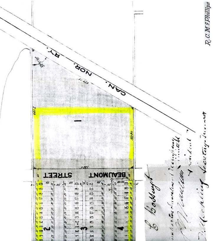
(Plate 7). This was evidently also in the works for the subject site, though the Rural Municipality
of Fort Garry was somewhat slow in forming an industrial policy. By 1953-1954, it had been
determined that the 150+ acre tract north of McGillivray Boulevard was to become Fort Garry’s
initial industrial park.3

During 1953, the subject site was acquired by the Fort Garry Development Company, Ltd., a
holding company associated with the C.T. Lount Construction Company. Charles Taylor Lount,
a brother of Frank Lount (who had created the Silver Heights subdivision in St. James), had by
then relinquished the running of his firm to his son, Graham C. Lount. The younger Lount began
making submissions to Fort Garry Council in late September 1953. Using Central Mortgage and
Housing Corporation (CMHC) funding, Lount proposed constructing 144 separate rental houses
on their 31-acre site. The rentals were to range from $54 to $62 per month per unit. A plot plan
of the proposed Lount development (which has not survived) was left with the Council. By
December, Graham Lount was back at Council, showing a plat of four bays opening on
McGillivray Boulevard., though retaining the 144 house-plan to be operated by the independent
McGillivray Park Ltd., for 40 years, financing would be done through CMHC, with dividends of
five percent per annum, with assurance of adequate maintenance and upkeep. The class of
tenants occupying the premises would have to be in an income bracket equal to four to six times
the amount of rent paid. Council tentatively agreed to Lount’s plan, though with a number of
conditions: 1) that the standard of houses and lot area per dwelling house would comply with the
building restrictions and Town Planning Scheme of the Municipality; 2) that the Provincial
Authorities would permit additional openings in McGillivray Boulevard as shown on the plan; 3)
as a school would be required, such school could only be established on Waller Avenue, and that
the plan should provide access to the school from each bay.4

Evidently, rumours about the project began to circulate, for Graham Lount was back to Council a
week or so later, denying that as a Low Rental Housing project, it was commonly referred to as a
“slum.” He stated that CMHC guidelines allowed for such projects, and that the regulations
governing McGillivray Park would allow for upkeep of the units. He also declared that the
project did not include the construction of a school. Fort Garry Council approved the plan in
principle, with the understanding that there would be one more full-width entrance to the

                                                 3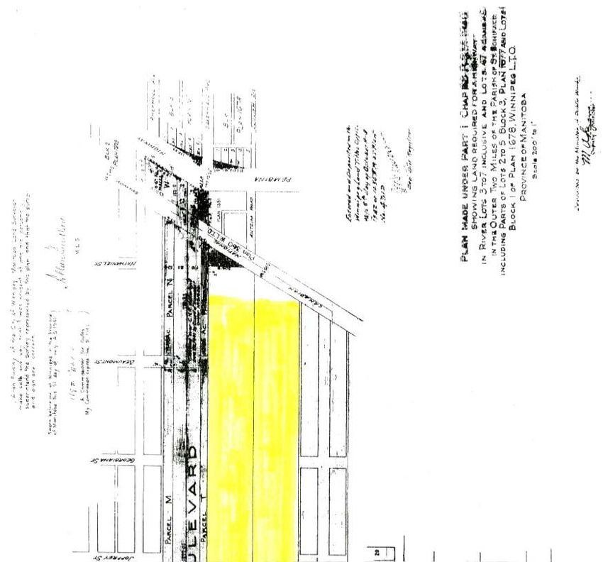
subdivision and that an amended plan be submitted to them. The next day, Council mulled over
the problem of the zoning – the M1 and M2 status left over from nearby Plan 4846 which
supposedly extended to this area did not allow for house construction. In addition, Grandin
School Board, into which the Lount subdivision would fall, was deeply opposed to the
construction of houses, on the ground that the Board could not afford to build another school. In
the new year, Council got around these objections in approving a 138-unit project, with Lount
naming the bays and assuming the costs of sewer and water infrastructure. The project would
tentatively cost $1,225,000, but still awaited CMHC approval. Completion was expected in the
autumn of 1954, with the two- and three-bedroom bungalows costing between $9,000 and
$10,000 each. Council also asked that six lots be set aside for playground purposes, though this
eventually became four on the final plat.5

Grandin School District remained a problem, however, and they had their supporters on Council.
Grandin had refused a school site on Waller Avenue to the south, and was demanding that the
Lount lands be reverted to light industrial zoning. It was found in February that no zoning by-law
had been passed up to that time that covered the Lount land, and that Council could not stop the
building because Lount had bought the property from private owners. What did stop Lount in
their tracks was the fact that CMHC would not approve of the separate house scheme. By late
February, an alternative plan was flown – Lount would build 60 four-unit family townhouse
units, where a two bedroom would rent for $54 a month, and a three-bedroom for six dollars
more. Council was unsure if it wanted more than single family units in the area, while the School
District remained quite opposed unless the developer also built the school. In early March,
Council rejected the town house proposal. At the time, the great change in Lount’s concept may
have been too great for the Council to comprehend, given the increased densities involved.6

A month later, however, the multi-unit project was back on, as Council agreed to modify the
town planning by-law to accommodate complexes of this type. This came in mid-May 1954, and
the beginning of June, the Lount Company began work on the first 30 units. Work progressed
during the summer of 1954, though Grandin School Board remained opposed because of the
necessary $160,000 10-room school which they could not afford. Despite this, Lount proceeded
with the entire project, predicting that the complex would be ready for occupancy in the spring of

                                                4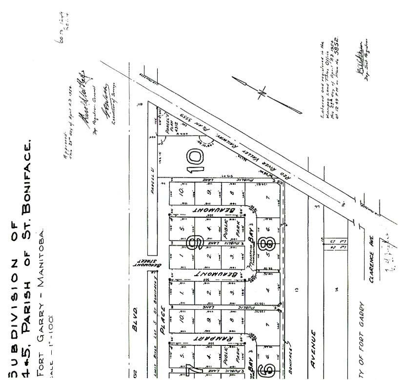
1955. The Lount development evidently also spurred thinking among house-building circles in
Winnipeg by mid-August 1954, as some proposals were floated around that time by CMHC and
the Manitoba and Northwest Command of the Canadian Legion to build 50 four-unit homes each
to cost about $3,000 and rent for $20 to $30 per month to veteran pensioners. Mentioned in
connection to this was the Lount project in Fort Garry. This likely evolved into the Canadian
Legion Gardens complex at 675 Talbot Avenue (1957), with the adjunct of the Kiwanis Courts
grouping in St. James (1957-1958).7

By mid-August 1954, Charles T. Lount was optimistic enough about construction progress to
state that the first residents would move into the $2,500,000, 60 quadraplex (240 unit) low rent
complex by late September. Each two-storey unit had its own basement as well as a living room,
dining room, kitchen and bathroom, with two to three bedrooms on the second floor. The three
bedroom units were to rent at $59 a month, while the two bedroom versions were six dollars less.
Four bays dominated the subdivision: Beaumont Bay, Rampart Bay, Biscayne Bay and Dickson
Crescent, a partial bay which ran off a northern extension of Vincent Street which was also part
of the Lount project. A playground or park was a feature of each bay, while foot access to the
south toward a lane and Waller Avenue was granted via three 10-foot wide pedestrian
thoroughfares. McGillivray Place ran along the north side of an access road to all bays, while
Vincent acted in the same capacity at the south (Plate 2). All in all, Mr. Lount appeared pretty
pleased with the job.8

Fort Garry Assessment Rolls indicate that the buildings on Block 9 were the first of the complex
occupied by October 1954. Blocks 8 and 7 followed in rapid succession during the period
October-December. Block 6 homes came up in February 1955, Block 4 in March/April; Block 5
by April, along with Block 2 and Blocks 1 and 3 by early May 1955. Mr. Lount had stated the
previous summer that hundreds had applied to rent apartments there. That they filled up quickly
is beyond doubt, for though the 1955 Henderson’s Directory showed only Beaumont and
Rampart bays, they had full tenancies. By the time of the 1956 Directory all bays and Vincent
were showing a full complement of renters. The C.T. Lount Company had shown with this
popularity that low-rent housing did not automatically mean “slum” as some had earlier alleged.
As for their single family housing project originally mooted for McGillivray Park – that wound

                                                 5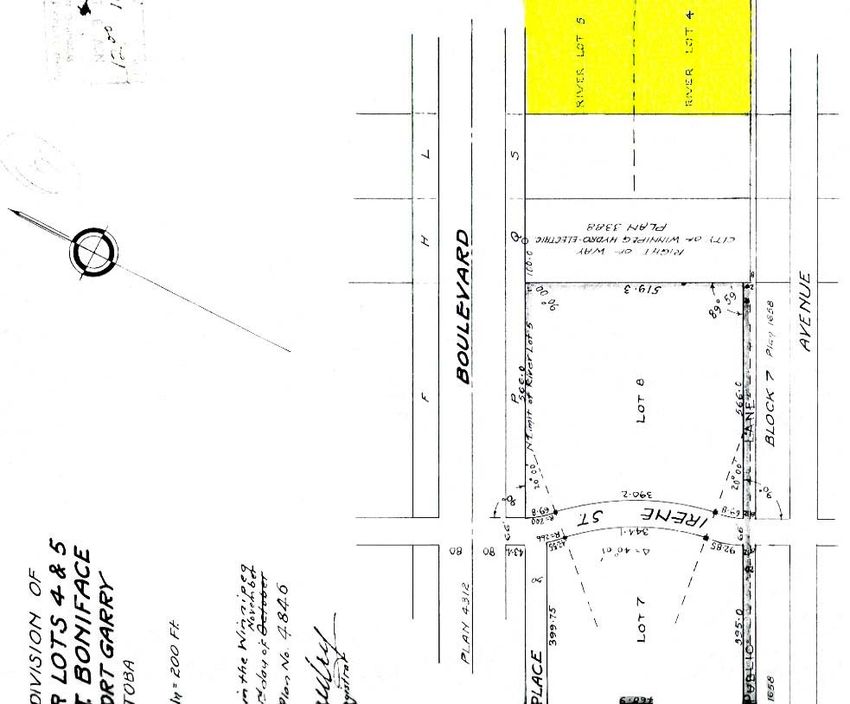
up along the northern edge of Windsor Park in St. Boniface. In the early fall of 1954, the Lounts
had announced a $3.5 million housing project on 50 acres south of Elizabeth Road along the east
side of Archibald. This was initially to have been similar to their Fort Garry complex with 100
four-unit houses. This was channelled into individual houses along Alderwood Bay, Argonne
Bay and Arundel Road that were sold to many owners. Lount’s St. Boniface development was on
Plan 6160, registered 20 September 1955 (Plate 9), and one suspects that some of the original
Fort Garry house designs found their way onto this four-block plat.9
In time, McGillivray Park did not swamp the educational resources of the district, as Ralph
Maybank School (Libling, Michener and Diamond, architects) was opened in February 1957 at
Waller and Donnelly. Other amenities would follow. Westridge United Church at 1226 Waller
opened in December 1958, while Westridge Community Club was built during 1958-1959. This
latter facility had been founded by residents of the Lount development to its north. McGillivray
Park was eventually altered by the Lount Corporation via Plan 14658 (registered 22 June 1979)
to reflect possible sales of individual units as that company got out of the rental business (Plate
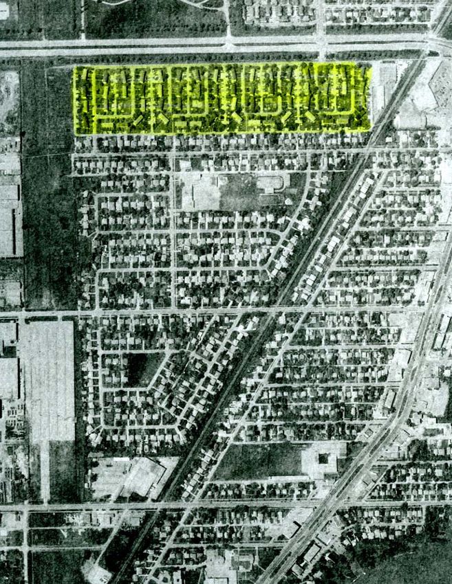
10, Parts A and B). By 1991, this was a mature, established neighbourhood.10 (Plate 11)
6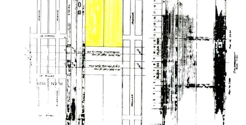
Plate 1.
State of subdivision in part of Fort Garry, ca. 1986. (City of Winnipeg)

                                                7
Plate 2.
McGillivray Park, aka Plan 5852, registered 28 April 1954. (Property Registry)
8Plate 3.
Southview advertisement. Given its subsequent history, Southview probably could not stand the
closer scrutiny offered by the magnifying glass. (Legislative Library of Manitoba, Winnipeg
Saturday Post, 20 April 1912, p. 3.)
9Plate 4.
Southview advertisement. In boom times the promises came thick and fast. (Legislative Library
of Manitoba, Winnipeg Telegram, 4 May 1912, p. 17.)
10Plate 5, Part A.
Southview Subdivision, aka Plan 2203, registered 27 December 1913. Most subdivisions were
registered soon after their initial advertising appeared in local newspapers. This one came a year
and a half later, possibly indicating sluggish sales because of the rural setting and a collapsing
realty market. This is the left-hand section of a very long drawing. (Property Registry)
11Plate 5, Part B.
Southview Subdivision, aka Plan 2203, registered 27 December 1913. Most subdivisions were
registered soon after their initial advertising appeared in local newspapers. This one came a year
and a half later, possibly indicating sluggish sales because of the rural setting and a collapsing
realty market. This is the central section of a very long drawing. (Property Registry)
12Plate 5, Part B.
Southview Subdivision, aka Plan 2203, registered 27 December 1913. Most subdivisions were
registered soon after their initial advertising appeared in local newspapers. This one came a year
and a half later, possibly indicating sluggish sales because of the rural setting and a collapsing
realty market. This is the right-hand section of a very long drawing. (Property Registry)
13Plate 6.
Part Plan 4312, registered 5 October 1942. McGillivray Boulevard took four years to build from
the time of this plan until the opening. McGillivray opened up access to farm land that had
earlier had limited access west of the CNR track. (Property Registry)
14Plate 7.
Plan 4846, registered 3 November 1948. Hot on the heels of the McGillivray opening was this
subdivision of a portion of the western part of the old Southview plat. Irene Street was kept in a
modified form while industrial-sized lots gave an indication of what was to come in the area.
McGillivray Place made its first appearance as a frontage road, and would reappear on Plan
5852. (Property Registry)
15Plate 8.
New subdivisions, showing Ralph Maybank School site, all south of McGillivray Park (City of
Winnipeg Archives. Metropolitan Town Planning Commission of Greater Winnipeg, Annual
Report for the Year 1955, p. 10.)
16Plate 9.
Plan 6160, registered 20 September 1955. Here, the C.T. Lount Construction Company was able
to build its single family housing instead of the townhouses originally envisioned for this part of
St Boniface. The houses were later sold to private owners. (Property Registry)
17Plate 10, Part A.
Plan 14658, registered 22 June 1979. Eventually the Lount Corporation sold off its Fort Garry
holding, parcelling out the land to reflect the individual ownership. This is the left-hand half of
the Plan. (Property Registry)
18Plate 10, Part B.
Plan 14658, registered 22 June 1979. Eventually the Lount Corporation sold off its Fort Garry
holding, parcelling out the land to reflect the individual ownership. This is the right-hand half of
the Plan. (Property Registry)
19Plate 11.
Aerial view of the McGillivray Park and environs, ca. 1991. By this time the Lount subdivision
had blended in with the residential areas to the south, despite its bay configuration which had
been innovative in 1954. (City of Winnipeg Archives, Aerial Views, ca. 1991, 5-75.)
20Endnotes
1. Manitoba Archives (PAM). Hudson’s Bay Company Register B; PAM – Parish Files, 4/5 St.
Boniface; Winnipeg Land Title Office. Old System Abstract Book. Winnipeg 111, pp. 4-5,
instruments 1245; 85193; 86412; 1760; 4147.
2. City of Winnipeg Archives (CWA). Rural Municipality of Fort Garry Assessment Roll (FG,
AR), 1912, Ward 1, p. 222; Winnipeg Saturday Post, 20 April 1912, p. 3; Winnipeg Telegram, 4
May 1912, p. 17, FG, AR, 1915, Ward 1, p. 465; 1919, Ward 1, p. 191; 1920, Ward 1, p. 202;
1921; Ward 1, no. 5035.
3. “New McGillivray Boulevard, Most Modern Road, Is Opened.”, Winnipeg Free Press (WFP),
4 September 1946, p. 3; CWA. FG, AR, 1946, Ward 1, p. 125.
4. CWA, FG, AR, 1952-1956, nos. 2878-2878JS; “Charles Taylor Lount.”; WFP, 3 December
1971, p. 25; CWA. Rural Municipality of Fort Garry Council Minutes, 29 September 1953, p. 1,
item 3; 15 December 1953, p. 1, item 1.
5 CWA, Minutes, 22 December 1953, p. 2, 9289; p. 5, 949/53; 23 December 1953, no. 1; “Fort
Garry Group Opposes Housing Plan.”, WFP, 24 December 1953, p. 7; “Fort Garry Council
Okays 138-Home Housing Project.” WFP, 12 January 1954, p. 3; “Fort Garry Project Seen
Starting Soon.”, WFP, 7 January 1954, p. 3; “Fort Garry Project For Industry This Year.” WFP,
27 January 1954, p. 3.
6. “Fort Garry Council Okays New 175-Home Subdivision.”, WFP, 10 February 1954, p. 3;
“Fort Garry House Scheme Unsettled.”, WFP, 24 February 1954, p. 3; “Fort Garry Raps C of C
For Backing By-Pass.”, WFP, 10 March 1954, p. 3.
7. “Fort Garry Council Backs Zoning Switch,”, WFP, 15 April 1954, p. 8; “Meet Called on Fort
Garry Zonal Change.”, WFP, 12 May 1954, p. 3; “Subdivision Housing Project Plans Opening
Spring.”, WFP, 11 August 1954, p, 17; “Low Cost Rental Project Studied.”, Winnipeg Tribune,
10 August 1954, p. 13.
8. “New Project Likely This Fall.”, WFP, 10 August 1954, p. 3.
9. CWA. FG, AR, 1952-1956, Ward 1, nos. 2878-2878JS; “New Project Likely This Fall.”, WFP,
10 August 1954, p. 3; “$3.5 Million Project Due in St. Boniface.”, WFP, 5 October 1954, p. 3.
10. Fort Lance, 31 January 1957, pp. 1, 8; 7 February 1957, p. 1; 4 December 1958, p. 4; 11
December 1958, p,. 4; 9 October 1958, p. 1; “Residents Move to Block Clubhouse.”, Fort Lance,
29 May 1958, p. 8.
21Appendix 2
The following detailed list of Winnipeg’s mid-century subdivisions features 79 entries, not counting
subdivisions which were built on older plans. A number of observations are possible from this inaugural
work:
1. New subdivisions did not necessarily emerge in the completed state in which we know them today.
Indeed, very few were first marketed in a completed state: rather, they evolved in bits and pieces into
the larger entity over a period of years. A prime example of this was Windsor Park, which was
marketed between 1954 and 1971 in a series of 26 plans. Westwood was another example, completed
in 1970 after a series of 21 plans that had started in 1958.
2. While many of these subdivisions were the product of single corporate bodies, others were
developed by combinations of firms and individual land holders at various times.
3. Many of the original names of these subdivisions have gone unrecorded on the Registered Plans, as
the practice of putting names such as “Bonnie Doon” or “Victoria Place” on those documents had
passed around World War I. With further research, some of those names may re-emerge. To provide
a name for a subdivision, it has often been necessary to resort to using area designations as shown in
Sherlock’s Map of Winnipeg and Surrounding Areas, 14th and 16th Editions. In some cases,
Sherlock’s usage is based on original subdivision names which have come to refer to much larger
areas than on the original plats. For example, there were parts of Fort Rouge which continue to refer
to themselves as Crescentwood, though they are far removed from the original Enderton subdivision.
The problem was solved by sticking solely with the Enderton plans to limit that which was being
written. This “widening out” has been a common practice in Winnipeg, unless one is dealing with a
confined, separate area such as Armstrong’s Point or Wildwood Park.
4. This present study represents new subdivisions that came into existence between 1941 and 1975. It
does not include suburbs which developed on older plans where the lot configurations remained
suitable in a later era. The Greater Winnipeg area had seen an explosion of subdividing in the period
1905-1912. While this led to initial development of various suburbs such as St. James, St. Vital and
East Kildonan, there was a certain amount of overkill in the process. Large areas of subdivided land
remained unsold and unbuilt at the Boom’s end in 1912, and would remain that way for the next
forty or fifty years. In many cases, most of the vacant lots were taken over for taxes by the various
municipalities. Often, where large groups of lots were involved, the municipality cancelled the
existing subdivisions, allowing the land to revert to acreage. In later years, such tracts became very
inviting for developers of various types. In other instances, the municipalities kept the old
subdivision in place, reselling their holdings to people and firms willing to build on what were
generally grid-iron pattern layouts. As a result, a 1957 house on a 1912 subdivision parcel would be
indistinguishable from a 1957 house on a 1956 era lot. Therein lies the problem, as this study deals
with the new suburban creations, while the others remain invisible. This happened in parts of St.
James, the Kildonans and St. Vital. In the latter instance, Victoria Crescent springs to mind. This was
a 1904 subdivision which did not really begin to be built up until the 1940s, and which continues into
the present time. Suburban development, yes, but presently beyond the scope of this project.
5. The author assumes that the 1945-1975 dates for this study were based upon similar dates as found in
Keshavjee and Enns’ Winnipeg Modern Architecture, 1945 – 1975. For practical concerns, the
starting date for this study begins in 1941 in order to include Norwood Grove which began re-
subdividing the old Plans 73 and 385 in that year. Along the way, two other suburban plans from
1943 and 1944 presented themselves. These were probably meant as post-war veterans’ housing
areas. Marlton and Dieppe-Coventry both saw their main development after 1950.
226. It must also be said that the dates of Registered Plans used in this study represent the first and last
plans that were registered in the area during the study period. Construction would, of course, take
place after both dates. This present study does not take notice of any registered plans issued after 31
December 1975 (aka Plan 12633), though some of the listed subdivisions marked kept growing
spatially after that time.
7. If this study has produced a listing which is cumbersome because of numbers, the author suggests an
earlier cut-off date. That would be 31 December 1971, the day prior to the inception of Unicity. That
could remove about 15 subdivisions from the list. As such, the list provides a guide where years or
decades could be selected for study on a piecemeal basis. Or individual subdivisions might be chosen
for further study, using the listed plan numbers to access that show how an area grew in the post-war
period.
8. The sources for this portion of the Suburbs Study consisted of the City of Winnipeg’s Area
Characterization books, which feature the zoning sheets that were superseded by the present
computer atlas in 1999. Those volumes depict the various areas of the former municipalities as they
existed between 1980 and 1986. Though superseded as a daily working document by the Planning
Department, they are of great use to a study of this type, which uses a cut-off date prior to 1980.
Those volumes generated registered plan numbers, street names and even river lot numbers. The plan
numbers led into the second source – the registered plans themselves, which are largely available on
microfilm produced by the City of Winnipeg in the 1980s. These cover Registered Plan numbers 1 to
22,000. While the film has some gaps, in the form of a handful of plans that were missing at the time
of filming, it has proven quite useful in formulating this listing. The plan will always have a
registration date, at which time the plan came into official existence. As well, there is often the name
of the land owner giving approval to the plan, as well as the name of the surveyor (or survey firm)
doing the work. The plan will also identify the land being subdivided, as well as showing any earlier
plan numbers being superseded.
9. There arises the question of group or social housing, a number of instances of which arose during
research. These were housing projects launched by service organizations, such as the St. James
Kiwanis which built the houses on Sinawik Bay in the 1950s, or the Royal Canadian Legion Gardens
on Talbot Avenue. Other instances of this have been found at McGillivray Place, or the barracks-
type buildings on Troy and Chamberlain avenues behind the Lincoln Hotel on McPhillips, or the
Anatole Seniors’ Hostel, 250-296 Templeton Avenue, and the Willow Park-Gilbert Park area in the
1960s. The social housing factor might make a salient feature for our study.
23City of Winnipeg Mid-century Suburban Subdivisions
Name Dates Registered Plans Remarks
Norwood Flats 1941-1953 4233; 4256; 4521; 4593; Re-subdivision of Plans 73 and
4804; 4805; 4911; 5712 385
Marlton 1943-1973 4375; 4713; 11178; 11370; Oakdale
11427; 11551 Drive/Marlton/Fairmont
Avenue
Dieppe – Coventry 1944-1973 4420;4771; 4962; 5826; Coventry/Buckingham/
5982; 6192; 8938; 11005; Cambrian/Dieppe
11029; 11120; 11314;
11449.
Roblin Park 1945 – Veterans 4540 Robindale/Greenbrier Area
Wildwood Park 1946 - 4565 Resubdivision of older
Wildewood area. Unique lay-
out
Riverbend – Garden 1946 4590; 4591 Riverbend Crescent/Garden
Road Road. Small Area
Silver Heights 1950 – 1953 5090; 5691; 5750 Mount Royal and side street:
Mount Royal
Crescent/Davidson/Whytewold.
Lount subdivision
Crowson – Sandra 1950 – 1953 5135; 5652 Riley/Wicklow/Crowson /
Bays Sandra Bays
Woodhaven 1954-1956 5996; 6339 Harris Boulevard/Armour
Crescent/Oakdean Crescent
Glenlawn 1953 5636 Glenlawn/Silverthorn Area
Rossmere – Fraser’s 1953 – 1957 5747; 6504 Rossmere Crescent /Glencoe /
Grove Larchdale /Rowandale
McGillivray Place 1954 + - Social 5852 Vincent / Biscayne / Rampart /
Beaumont Bays. Social
Housing
24Windsor Park 1954 – 1971 5910; 6160; 6265; 6298; Large Housing Development,
6324; 6486; 6557; 6708; mostly by LADCO
7282; 7291; 7422; 7551;
7618; 7660; 7714; 7805;
8156; 8205; 8279; 8631;
8697; 8715; 8720; 9007;
9343; 10867
Niakwa Park 1955 – 1963 6142; 8134 Comanche / Niakwa Roads
Kebir Place 1955 – 1956 6159; 6361 Crane Avenue / Kebir Place /
Dove Bay / South Drive
Sturgeon Creek 1955 – 1968 6165; 7014; 8027; 8230; Amaryth / Wharton Boulevard
8679; 9138
Garden City 1955 – 1963 6187; 6271; 6900; 7295; Large Housing Development by
8123 Model Home Ltd
Bird – Fort Garry 1956 1959 6264; 7007 Marshall Bay / Maybank /
Area Clarence Avenue. Built by
Bird Construction, Ltd
Sherwood Park 1956 – 1968 6289; 6965; 9850 Munroe / Ayers Area
Morse Place 1956 6316 Munroe / Hoskin, east of
Gateway
Pulberry 1956 – 1964 6369; 7067; 7514; 7874; Tod Drive / Parkville / Arden
8677
Golden Gate 1956 – 1959 6398; 7069 Moray / Rita resubdivision of
older plan
Douglas 1957 – 1975 6495; 7555; 8206; 9640; Gilmore / Summerfield /
9785; 9964; 10712; 10796; Autumnlea / Winmart, etc.
11072; 11257; 11274; Large subdivision. E. of
11615; 11664; 11741; Henderson Hwy N. of Peguis
11922; 12008; 12016;
12321; 12355; 12469;
12479; 12516; 12534
Westview 1957 6501 Cloverdale / Kootenay Crescent
Birchwood Heights 1957 6564 Assiniboine Crescent /
Pinewood Drive
Kiwanis Place 1957 – 1958 – 6671 Ness / Sinawik Bay. Social
Social Housing
25Willowdale 1958 6712 Willowdale Place. Small
subdivision
Jameswood 1958 6750 Ness / Jameswood Drive Area
Springfield Heights 1958 – 1962 6793; 7305; 7826 Edision / DeGraff / Eade / Arby
/ Macaulay
Dundoon – Durness 1958 – 1962 6878; 8247 McLeod / Dundoon / Durness /
Cameo Crescent / Kirkwall
Crescent
Westwood 1958 – 1970 6829; 7016; 7103; 7161; Westwood Drive. Poets and
7446; 7849; 7902; 8029; Authors side streets. Large
8074; 8170; 8331; 8422; Subdivision
8485; 8646; 8793; 8861;
9486; 9598; 10135; 10434;
10615
Clyde Park 1958 6904 Clyde / Panet Road.
Resubdivision of older plan
Thatcher Drive 1959 7003 Thatcher / Agassiz Drive
Riviera Crescent 1959 7071. Connected Closing part of Riviera
w/wildwood
“New” Transcona 1959 7050; 8026; 8226; 8392; Kildare / Brewster Bay / St.
8568; 8600; 8851; 11953; Martin Boulevards, etc...
12558
Beaumont Park 1959 – 1964 7077; 8776 “The Planets” – Mars / Saturn /
Neptune / Jupiter / Mercury
Bays
St. Norbert 1960 -1962 7207; 7473; 7642; 7986 Lemay Avenue / Campeau /
Ste. Therese area east of
Highway
Darwin 1960 – 1972 7229; 10593; 10692; Riel Avenue / Oakridge /
10935; 11179; 11180; Avalon / Minnetonka, etc...
11232; 11241; 11254;
11258
Crestview 1961 – 1971 7583; 7595; 8016; 8183; Crestview / Fairlane / Morgan /
8501; 8603; 9226; 10227; Bellevista, etc…
10920
Southboine 1961 – 1974 7526; 9135; 9783; 10190; Paradise Bay / Kinkora /
11109; 11192; 12044 Southboine Drive
26Beaumont 1961 – 1973 7597; 7693; 9988; 10686; Rannock / Municipal / Berkeley
11671 Area
Litz Place 1961 – 1971 7614; 7720; 8024; 9388; Litz Place / Tamarind area.
9596; 10577; 10805 For A. Litz Homes, Ltd
Heritage Park 1962 – 1969 7868; 8364; 8511; 10281 Heritage Boulevard / Stillwell /
Sturgeon / Caron / Carriage
Road
Athlone 1962 – 1964 8055; 8590 Red Robin / Athlone /
Nightingale Road
Bunn’s Creek 1963 – 1975 8145; 8376; 8390; 9118; Algonquin Avenue / Diamond /
9360; 9831; 10966; 11176; Brahms Bay, etc. Large
11243; 11459; 11741; Subdivision
11919; 12213; 12298;
12324
East Tuxedo 1963 – 1971 8286; 10742; 11004 Cuthbertson Place / Edgeland
Portsmouth Blvd.
Former Plan 1714.
Parc LaSalle 1963 - 1973 8419; 9079; 10625; 10924; Houde Drive / Ducharme /
11424; 11503 Gendreau
Margaret Park 1963 – 1971 8437; 10766 Leila / Sly Drive / Aikins /
Seaforth. Large Subdivision
Fort Richmond 1964 – 1975 8579; 8582; 8733; 8969; Large Subdivision by LADCO
9020; 9326; 9345; 9533;
10067; 10358; 10886;
10969; 10985; 11030;
11077; 11700; 12217
South Tuxedo 1964 – 1971 8726; 9563; 10795 Bower Boulevard / Hedley /
Shaftesbury / Bard
Elmhurst 1965 – 1975 8894;9286; 9854; 10112; Epsom Crescent / Haney /
10235; 10313; 10610; Royal Road
10752; 10838; 10839;
11071; 11081; 11134;
12062; 12269
River Park West 1965 – 1975 8896; 10033; 11742; Barker Boulevard / Xavier
11743; 11983; 12203 Drive
27Westdale 1965 -1975 8929; 8948; 9046; 9663; Dale Boulevard / Hammond
9742; 9834; 9896; 10099; Road / Dellwood, etc. Large
10294; 10544; 10627; Subdivision
10851; 10951; 11108;
11306; 11156; 11489;
11734; 11796; 12009;
12074; 12103; 12316
Southdale 1965 – 1975 8979; 8980; 9221; 9327; Lakewood Boulevard, etc.
9432; 9592; 10241; 10342; Large Subdivision
10414; 10475; 10875;
10954; 11076; 11090;
11889; 11890; 12427
Valhalla Gardens 1965 9085 Valhalla Drive. Apartment
Subdivision
Donwood 1966 – 1969 9133; 9267; 9462; 9776; Donwood Drive / Jessica Drive
10140; 10903; 11651; / Gemini Avenue etc.
11755
Woodgreen – 1966 9269 Prairie View / Woodgreen /
Emerald Grove Emerald Grove
Parkway Square 1966 9275 Tanoak / Embassy
Braeside 1967 – 1968 9497; 9916 Louelda / Moncton / Fleming
Lakewood 1968 – 1975 9839; 10122; 10188; Lakeridge / Kay / Buchanan /
10311; 10371; 10900; Risbey / Isbister. Former Plans
10981; 11097; 11182; 6119/6831
11215; 11281; 11589;
11595; 11713; 11740;
12151; 12256
Scotswood 1968 – 1974 9942; 9971; 11312; 11961 Community Row / Betsworth /
Rannock / Scotswood
Pacific Junction 1968 – 1975 9854; 10225; 10610; Elmhurst / Cathcart / Shetland
10620; 10667; 10885;
10901; 11214; 11302;
12269
Maples 1970 – 1975 + 10512; 10536; 11025; Jefferson / Masterson, etc
11059; 11060; 11170; Large Subdivision by BACM
11218; 11229; 11492;
11554; 11606; 11887;
11909; 11916; 11951;
12264; 12294; 12295;
12296; 12486
28Oxford Heights 1970 – 1971 10631; 10690; 10958 McMeans / Paulley Drive /
Dowling / Thom
Valley Gardens East 1971 – 1974 10971; 11028; 11238; Antrim / Louelda / Snowdon /
11255; 11324; 11480; Tu–pelo / Green Valley. Large
11582; 12025; 12093 Subdivision
St. Michael 1971 – 1975 11007; 11898; 12325 St. Michael Road / Kilmarnock
Meadowood Park 1971 – 1975 11008; 11818; 11931; Knightsbridge / Pembridge /
11992; 11995; 12276 Meadowood / Thunder Bay
Country Club 1971 – 1972 10964; 11058 Country Club Boulevard
Ridgedale 1972 – 1973 11107; 11339; 11551; Roblin / Jaymorr / Fairway
11616; 11941; 12370 Place
Valley Gardens West 1971 – 1973 10971; 11221; 11425; Antrim, etc, Former Plan 767
11431
River Pointe 1973 -1974 11762; 11946 Harry Collins Avenue / St.
Germaine Street
Vista 1974 12030; 12106 Vista Avenue / Rattai Place
Former Plan 1887
Waverley Heights 1974 11860; 11867 Pembina / Markham. Former
Plan 8973
Mission Gardens 1974 – 1975 11915; 12024; 12290 Rougeau / Hatcher / Bernard
Bay
Glendale 1975 12446 Gagnon / Suzanne Bay
Ambassador Row 1975 + 12487 Ambassador / Diplomat
Harbor View 1975 + 12556 Springfield Rd / Cox Blvd.
Callsbeck 1975 + 12595 Callsbeck Ave. Seven Lots
Riverbend 1975 + 12628 Donan Street. Former Plans
1894/4408
29You can also read