MEDKEYHABITATS EXTENTED TEAM - FORUM
←
→
Page content transcription
If your browser does not render page correctly, please read the page content below
Mapping of Key Marine habitats in the Mediterranean and promoting their
conservation through the establishment of Specially Protected Areas of
Mediterranean Importance

Cartographie des habitats marins clés de Méditerranée et promotion de leur
conservation par l’établissement d’Aires Spécialement Protégées
d’Importance Méditerranéenne

MedKeyHabitats Extented Team

                                         Organised by: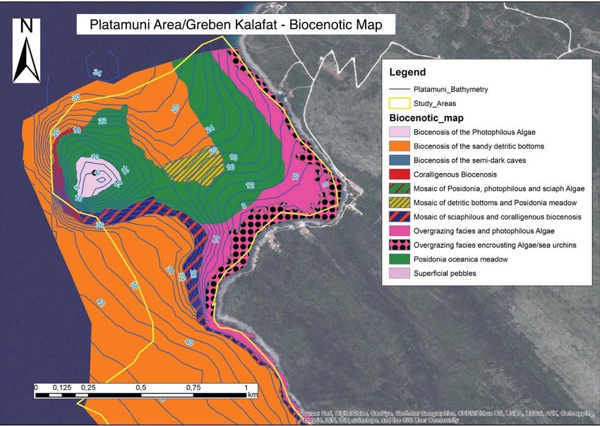
Context

     SPA/BD Protocol                                    SAP-BIO
     The     Protocol    concerning                     Strategic Action Programme for
     Specially Protected Areas and                      the Conservation of Biological
     Biological Diversity in the                        Diversity in the Mediterranean
     Mediterranean                                      Region

                                      Actions Plans for the conservation of key
                                      habitats in the Mediterranean (marine
                                      vegetation, coralligenous and dark habitats)

                                        Organised by: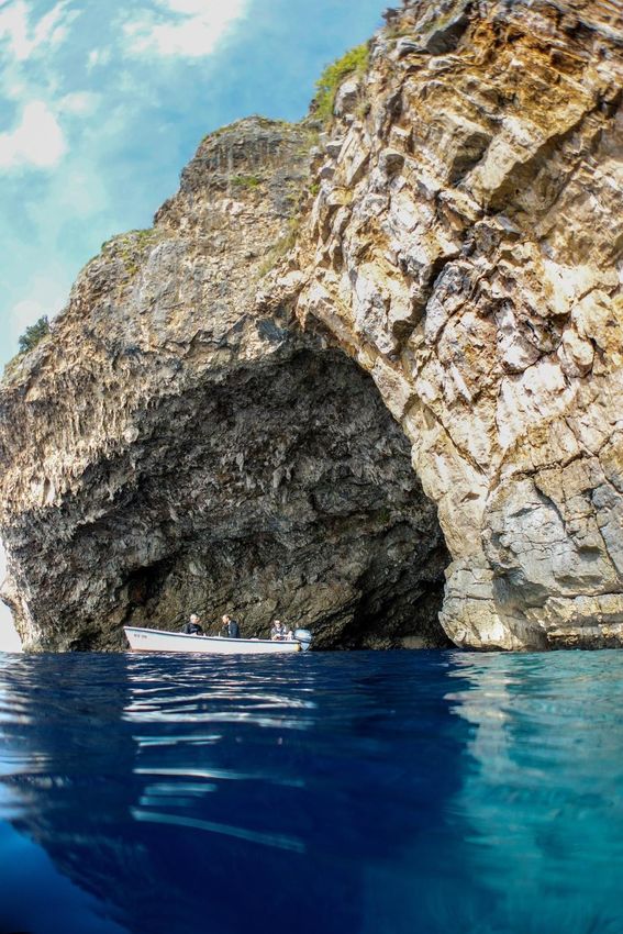
Context

        MedMPA
 2003   Assistance to countries for creating and
        managing SPAs.

        MedPosidonia Project
 2006   Establish inventories, cartography and
        monitoring networks of seagrass meadows.

        SPAMIs in Open Seas
        establishment of a representative network of
 2008   marine protected areas in the Mediterranean
        open seas, including the deep seas.

        MedMPAnet Project
        Development of a Mediterranean Marine and Coastal
 2010   Protected Areas (MPAs) Network through the boosting of
        MPAs Creation and Management.
        MedKeyHabitats
        Mapping of key marine habitats in the Mediterranean and
 2014   promoting their conservation through the establishment of
        Specially Protected Areas of Mediterranean Importance.

                                                                       02
                                                       Organised by: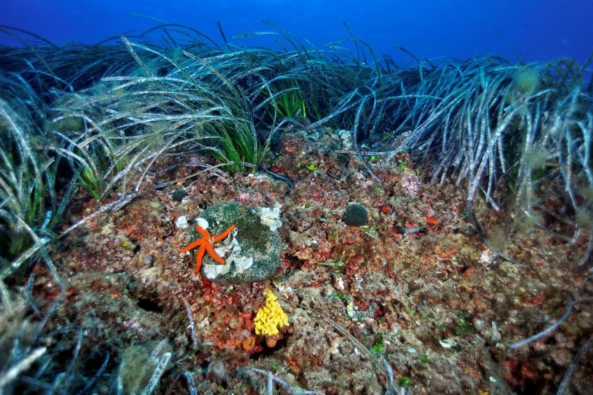
The MedKeyHabitats project
•   Duration: 2013-2015 (36 months)
•   Starting Date : December 2013
•   Executing agency: Regional Activity Centre for Specially Protected
    (RAC/SPA)
•   Source of funding: MAVA Foundation
                                                     MAVA Contribution   RAC/SPA Contribution

                                               24%
•   Total Project : 1 004 625 €
     –   Contribution of MAVA : 765 785 €
     –   Contribution of CAR/ASP : 238 840 €
                                                                               76%

                                                 Organised by: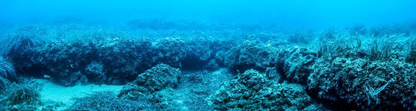
Objectives
The project aims to establish cartographic inventory of
marine habitats of conservation interest to extend the
Specially Protected Areas of Mediterranean Importance
network (SPAMIs)

Objective 1: Develop cartographic inventory of marine key
habitats of conservation importance

Objective 2: Strengthening the SPAMI network

                                 Organised by: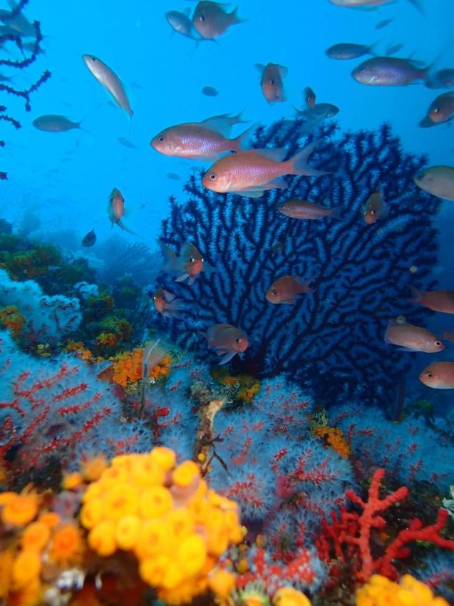
Geographical outline of the project

                     Organised by:
Organised by:
MedBiodivSDI

               Organised by: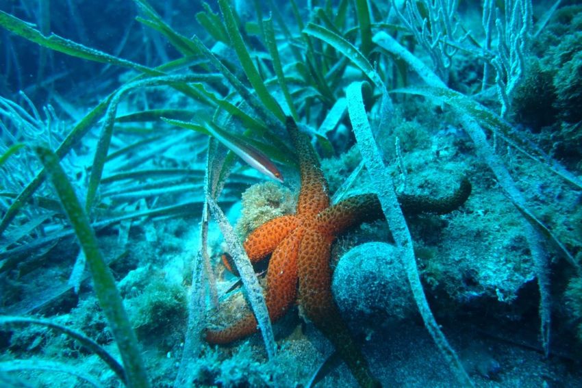
9%                    15%
                    6%                                                 Coordination

Budget use                                                             Objectif 1 : Cartographic inventory

                                                                       Objectif 2 : Enhencement of SPAMI
                                                                       Network
                                                                       other (administrative costs etc…)
                                70%

         4%
              14%

                              12%
                                                Training

                                                Communication

                                                Countries Activities

   70%                                          SPAMI conference

                               Organised by:
THE PROJECT – NUMBER CRUNCHING

• Beneficiary countries : 8
• Partner institutions and organizations : 30
• Sites mapped : 5
• Total surface area prospected (km2) : 66,38
• Field survey days : 85
• Maps produced : 12
• Species inventoried : 538
• Species listed in international conventions : 51
• Permanent systems set up for monitoring marine key habitats : 10
• New sites included on the SPAMI List : 1
• Scientific events organised or co-organised : 4
• Regional training sessions : 2
• Persons trained : 105
• Photos taken : 1200
• Video recordings : 140 min

                                         Organised by:
Albania / Albanie
Ministry of Environment, Forestry and Water
Administration Morocco / Maroc
Agency of Protected Areas Haut Commissariat aux Eaux et Forêts et à la Lutte
Contre la Désertification
Algeria / Algerie Université Mohammed V - Agdal
Ministère des Ressources en Eau et de Faculté des Sciences de Rabat
l’Environnement Association 3C plongée
Commissariat National du Littoral
Abyss Environmental Services Montenegro / Monténégro
Association Ecologique Marine d’Oran « Barbarous » Ministry of Sustainable Development and Tourism
Environmental Protection Agency of Montenegro
Egypt / Egypte Institute for Marine Biology, Kotor
Egyptian Environmental Affairs Agency
Slovenia / Slovénie
Spain / Espagne Institute of the Republic of Slovenia for Nature
University of Alicante Conservation
University of Seville
Mediterraneo Servicios Marinos S.L. Tunisia / Tunisie
Ministère des Affaires Locales et de l’Environnement
France Agence de Protection et d’Aménagement du Littoral
Université de Corse Pascal Paoli Institut National Agronomique de Tunis
Association « Notre Grand Bleu »
Greece / Grèce WWF, Tunis
Hellenic Centre for Marine Research, Crete Okianos
Italy / Italie
International Marine Centre, Oristano
Golder Associates
Libya / Libye
Environment General Authority
Omar Al-Mukhtar University
Organised by:Organised by:
Overview of mapping technics of
marine key habitats by the use of Side-
Scan Sonar and ground-truth

Giovanni Torchia
Golder Associates

                     Organised by:
Context
• Framework: MedKeyHabitats Project in Montenegro (Ratac and
Platamuni) and in Tunisia (Cap Negro)
• Main Scope: a full coverage maps of the marine habitats
distribution in order to define appropriate measures to ensure the
conservation of the sites of interest
• Mapping activities: carried out by integrating geomorphological
(Side Scan Sonar), bathymetric (single beam) and biological data
(scuba diving, underwater video and photographic samplings,
underwater towed camera and sediments collection)
Study areas
• Platamuni - 10 km of coast length; area of 8,4 km2
• Ratac - 1,4 km of coast length; area of 1 km2
• Cap Negro – 15 km of coast length; area of 47 km2
Organised by:Side Scan Sonar
• SSS was made in the 1950s; first documented use in the
Mediterranean for habitat mapping in 1976.
• Based on the diffraction of acoustic waves. A significant
technological development in the last decades.
Reasonable costs. Total coverage of study areas.
• Georeferred images like aerial photos of the sea
bottom.
According to the site
characteristics also other
approaches are apropriate:
• Scuba divers towed by
hydroplane for initial
speedy survey
• Transect with ROV in very
rough bottom dominated
by hard substrata
Organised by:Cap Negro Cap Negro
Platamuni Ratac
Organised by:Grab
sample
Video
transect
Diving
Organised by:Organised by:
Ground-trouth

                Organised by:
Drawing up of the map
Organised by:Organised by:
Organised by:
Organised by:
• The implemented approach within the MedKeyHabitats project in
  Tunisia and Montenegro allows:
   – to have total coverage (no interpolation);
   – to have map at a detailed scale (1:5.000 with zoom 1:1.000) and
   – to map large areas

                                       Organised by:
Conclusions
• Benthic maps represent one of the most powerful tool for the
management/protection of marine areas:
– Zoning, adjustment of surface (S.O. 1 - action 1.1; S.O. 3 - action 3.1; 3.8)
– Habitat and species inventory (S.O.1 - action 1.3)
– Input to national gap analysis (S.O. 1 – action 1.4)
– Data for candidacy to regionally MPAs (S.O. 1 – action 1.6)
– Input to habitat databases (S.O. 1 – action 1.9)
– Base for monitoring system (S.O. 2 – action 2.2)
– Indication for management plan (S.O. 2 – action 2.3)
– Tool to assess the impact of visits and fishing (S.O. 2 – action 2.20)
– Key element for the marine spatial planning process (S.O. 3 - action 3.10)
– Data for the evaluation of ecosystem services (S.O. 3 - action 3.12)
– Allow to create a point zero, to which add further details
Organised by:Inputs for the discussions
Tangier Declaration (Draft) - Item 1.7 – Complete the
mapping of marine key habitats and in particular
seagrass meadows and coralligenous formations by 2020
• Is it enough? Further details? Further habitats
• Invitation to the scientific institutions and researchers to
improve/solve some open issues (e.g. habitats extension
on vertical and steep bottom; habitat classifications)
• Key role of the awareness of what there are underwater.
Promote and increase the spreading and sharing of
maps
Organised by:Overview of Results in Montenegro
Milena BATAKOVIC
Environmental Protection
Agency
Vesna MAČIĆ
Institute of marine Biology of
Kotor
Giovanni TORCHIA
Golder Associates
Organised by:Organised by:
Organised by:
The presence of a habitat of special interest formed of Posidonia on an organogenic
substratum, rich in microhabitats and with enclaves of the shade-loving
coralligenous biocenosis, gives a certain ecological interest to the Ratac Marine
Area.

As regard Platamuni, it is characterized by its main marine cave on the south of
Bigova, with at its entrance an extraordinary development of bio-constructions.

It also hosts a vast Posidonia oceanica meadow on rock on the western side of
Greben Kalafat, continuing as deep coralligenous assemblages on rock.

                                            Organised by:
Organised by:
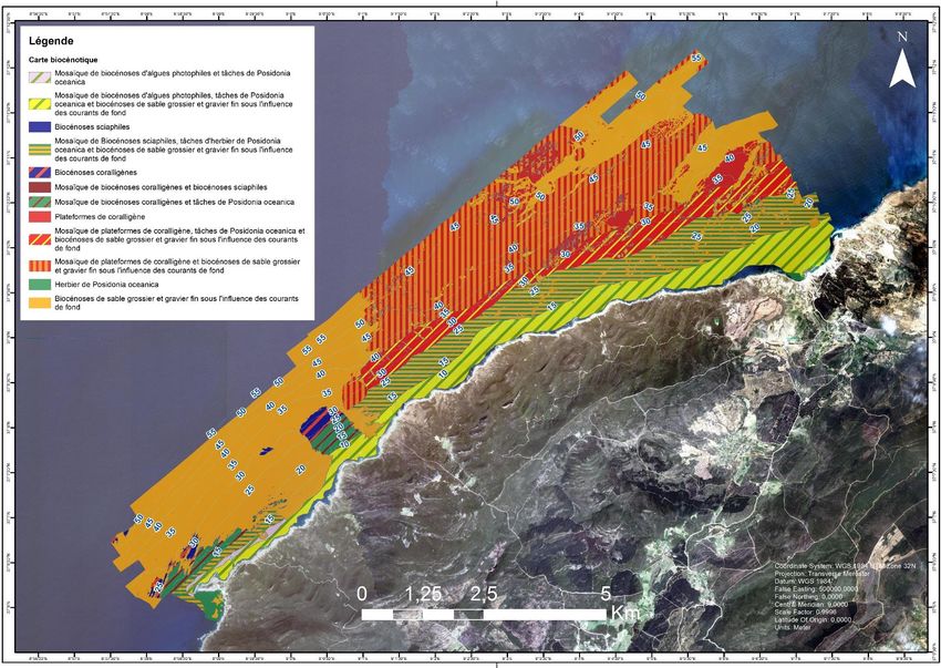
Overview of Results in Tunisia

Saba GUELLOUZ
Agence de Protection et
d’Aménagement du Littoral

Giovanni TORCHIA
Golder Associates

Chedly RAIS
OKIANOS

                            Organised by:
Organised by:
Organised by:
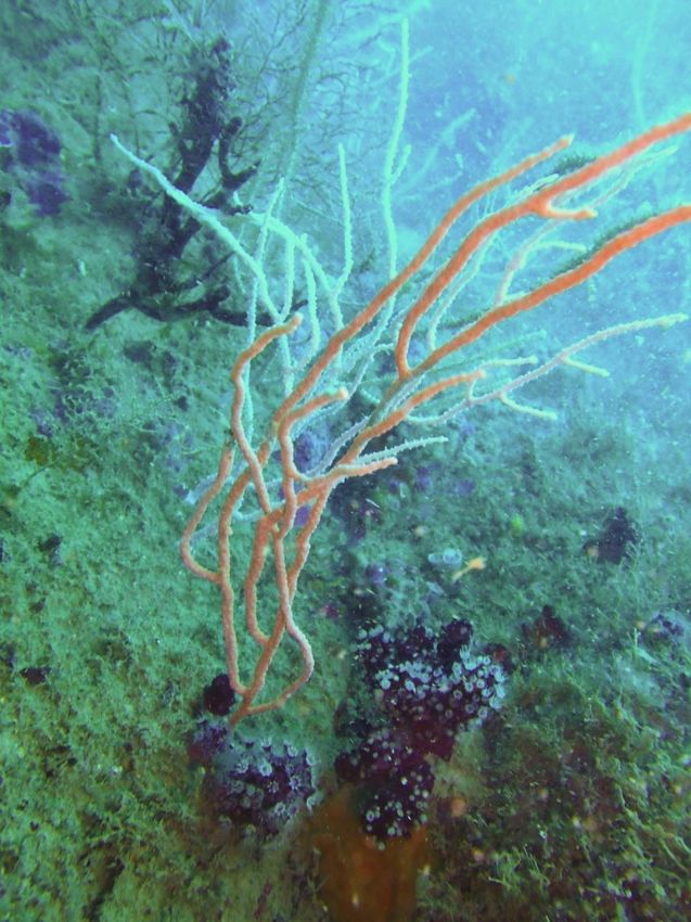
Altogether, the priority habitats (Posidonia meadows,
various coralligenous and sciaphilic biocenoses) cover a
surface area of some 30 km2 out of a total 48 km2 of
the study area, that is, 63 % of the area studied.
The uniqueness and value of this area lie in:
• the exceptional extent of the coralligenous platform
   (over 16 km2 bearing in mind the mosaics of
   coralligenous platforms)
• the great extent of the facies with Eunicella (a
   fragile specie of gorgonian)
• the good conservation level of the marine
   ecosystems.

        Organised by:
Organised by:
Hydroplane transecs
• Exploratory survey => location plot stations
• Low cost
• Simple and fast (45’ => 1500m, 1,5ha), max. depth 40m
• Any diver with training
• Ground trouth (same dive)
• Improvement: GoPro
• Pneumatic or small fishing boat: 3 persons:
   – skipper (navigation, GPS, time),
   – support diver (hand-echosounder, writing, security),
   – diver (observations)
• Data treatment: Q-GIS
• Limitations:
   – Precission ± 10m
   – Security: no in fishing zones
    (fixed nets, traps)
                                           Organised by:
Overview of Results in Algeria
Saida LAOUAR
Ministère des Ressources
en Eau et de l’Environnement
Mouloud BENABDI
Abyss Environmental Services
Alfonso Angel RAMOS ESPLA
University of Alicante
Organised by:Organised by:
Organised by:
The Posidonia oceanica meadow, very localised in
the southern part of Rachgoun, is of great scientific
importance because it lies close to the western limit
of the area of Posidonia distribution in North
Africa. A monitoring system has been set up on the
Posidonia meadow to monitor its evolution over the
long term. The data collected will make it possible
to better understand the issue of climate change
impacts on this Mediterranean flagship species.
The coralligenous is unlike the other Mediterranean
communities in its low level of bio-concretion, the
absence of certain species of sponge common in the
region. However it presents a well-developed upper
stratum with gorgonians dominating.

       Organised by:
Overview of Results in Morocco
Zouhair AMHAOUCH
Haut-Commissariat aux Eaux et
Forêts et à la Lutte Contre
la Désertification
Hocein BAZAIRI
Université Mohammed V-Agdal
Faculté des Sciences de Rabat
Free Espinosa
University of Seville
Organised by:Organised by:
Organised by:
The site of Jbel Moussa hosts the
   only meadows of Zostera marina
   still surviving in the Moroccan part
   of the Mediterranean, indeed in
   North Africa.

   It is also home to the red coral
   Corallium rubrum, present in fairly
   shallow areas, with rates of cover
   of sometimes nearly 100 %.

   These two characteristics make
   the Jbel Moussa site exceptional
   at regional level.

Organised by:
Organised by:
THANK YOU – MERCI - شكرا
MedKeyHabitats Extented Team
Organised by:Albania / Albanie
Ministry of Environment, Forestry and Water
Administration Morocco / Maroc
Agency of Protected Areas Haut Commissariat aux Eaux et Forêts et à la Lutte
Contre la Désertification
Algeria / Algerie Université Mohammed V - Agdal
Ministère des Ressources en Eau et de Faculté des Sciences de Rabat
l’Environnement Association 3C plongée
Commissariat National du Littoral
Abyss Environmental Services Montenegro / Monténégro
Association Ecologique Marine d’Oran « Barbarous » Ministry of Sustainable Development and Tourism
Environmental Protection Agency of Montenegro
Egypt / Egypte Institute for Marine Biology, Kotor
Egyptian Environmental Affairs Agency
Slovenia / Slovénie
Spain / Espagne Institute of the Republic of Slovenia for Nature
University of Alicante Conservation
University of Seville
Mediterraneo Servicios Marinos S.L. Tunisia / Tunisie
Ministère des Affaires Locales et de l’Environnement
France Agence de Protection et d’Aménagement du Littoral
Université de Corse Pascal Paoli Institut National Agronomique de Tunis
Association « Notre Grand Bleu »
Greece / Grèce WWF, Tunis
Hellenic Centre for Marine Research, Crete Okianos
Italy / Italie
International Marine Centre, Oristano
Golder Associates
Libya / Libye
Environment General Authority
Omar Al-Mukhtar University
Organised by:Inputs for the discussions
Tangier Declaration (Draft) - Item 1.7 – Complete the
mapping of marine key habitats and in particular
seagrass meadows and coralligenous formations by 2020
• Is it enough? Further details? Further habitats
• Invitation to the scientific institutions and researchers to
improve/solve some open issues (e.g. habitats extension
on vertical and steep bottom; habitat classifications)
• Key role of the awareness of what there are underwater.
Promote and increase the spreading and sharing of
maps
Organised by:You can also read