Altona and Seaholme Local Flood Guide - Flood information for Altona and Seaholme in Hobsons Bay - Victoria State Emergency Service
←
→
Page content transcription
If your browser does not render page correctly, please read the page content below
Altona and
                 Seaholme
Local Flood Guide
Flood information for Altona and Seaholme in Hobsons Bay

                        Hobsons Bay

For flood emergency assistance call
VICSES on 132 500

Reviewed: 1 July 2020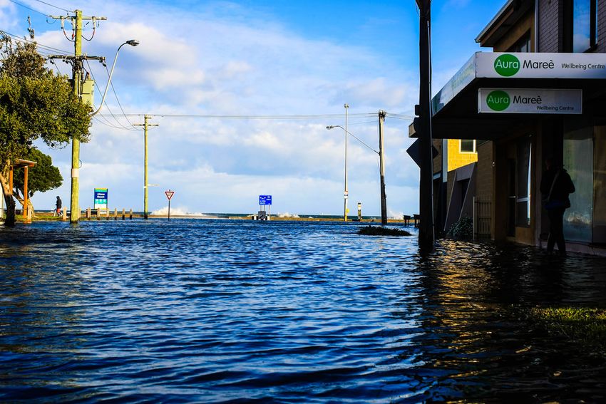
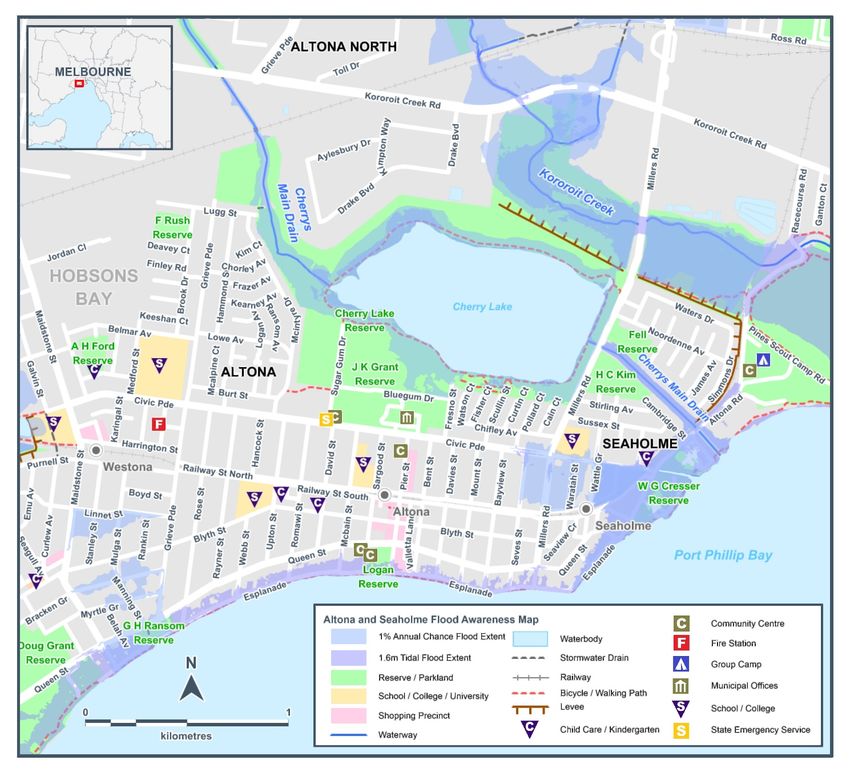
Local Flood Guide                  Hobsons Bay

Hobsons Bay
Altona and Seaholme are suburbs that are home to one of only two suburban swimming beaches west of the
Melbourne Central Business District. As coastal suburbs, Altona and Seaholme whilst being predominantly
residential, are also full of coastal walks, parks and reserves that are popular with locals and visitors alike. In
addition to the ocean, other waterways in the area include Laverton Creek, Cherry Lake and Kororoit Creek.

Altona and Seaholme have relatively flat terrain. This, in combination with the waterways and ocean, put the
areas at risk of storm surge, river and flash flooding.

The map below shows the impact of a 1% flood in the Altona/ Seaholme area. A 1% flood means there is a
1% chance a flood this size could happen in any given year. This map is provided as a guide to possible
flooding in the area.

Disclaimer
This map publication is presented by Victoria State Emergency Service for the purpose of disseminating emergency management
information. The contents of the information have not been independently verified by Victoria State Emergency Service. No liability is
accepted for any damage, loss or injury caused by errors or omissions in this information or for any action taken by any person in reliance
upon it. Flood information is provided by Melbourne Water.

Reviewed: 1 July 2020                                                                                                                    2
Local Flood Guide Hobsons Bay
Are you at risk of flood?
Altona and Seaholme are coastal suburbs on relatively flat terrain. This makes the stretch of land near the bay
susceptible to flooding during high intensity rain or storm events. When a storm occurs during a very high tide
and southerly winds, sea water can come over the flood wall next to the beach. This is called ‘storm surge’
flooding and results in Beach Street and The Esplanade flooding frequently; especially near Sargood and
Bayview street. It can also lead to potential flooding of underground car parks.
Flash flooding can also be an issue for the Altona/ Seaholme area, where a high amount of rain occurs and
can’t drain away fast enough. This can especially occur during high tides where the drains can struggle with
the push of water back from the ocean combining with the
flat terrain of Altona and Seaholme. Areas that can be
No two floods are the same.
affected include:
Floods like this or worse
McIntyre Drive could occur again.
Civic Parade all the way to McIntyre Drive If you live in a low-lying area you may be
at risk of flooding or need to detour
The area between Civic Parade and the railway line
around flooded areas.
from Seves Street
Areas south of Linnet Street, either side of Mulga/ Knowing what to do can save your life
Manning Street. and help protect your property.
Finally, the Altona and Seaholme area is also at risk from
flooding during longer rain events where Laverton Creek,
Cherry Lake and Kororoit Creek could flood. Green areas and levees in the area provide some protection for
properties, but the Altona/ Racecourse road and sections of the Werribee railway line may be flooded if the
Kororoit Creek overflows.
Areas at risk of flooding in Altona and Seaholme should be avoided if flooding occurs. These include:
ALTONA McIntyre Drive SEAHOLME
Civic Parade Millers Road Acacia Avenue
Grieve Parade Robin Street Central Avenue
Kororoit Creek Road Seagull Avenue Civic Parade
Dove Avenue Seves Street Waratah Street
The Esplanade Stanley Street Wattle Grove
Linnet Street Taras Avenue (ALTONA
NORTH)
Reviewed: 1 July 2020 3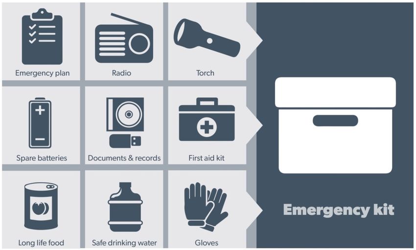
Local Flood Guide Hobsons Bay
Flood warnings and
emergency checklist
Did you know?
Altona and Seaholme have a history of flooding, including flooding in 1963, 1977, 1983 and 2005. More
recently, flooding has occurred in the area with the following results:
In January 2020, a man had to be rescued from his car by SES on Kororoit Creek Road after the road
became flooded due to heavy rain.
Other rescues of people from their cars trapped in flood water occurred in June 2019 on Merton Street
and in December 2017 on Racecourse Drive.
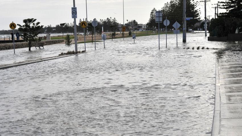
In 2010, all underground residential car
parks near The Esplanade and Beach
Street flooded due to heavy rain.
The Esplanade, Altona. 24th June, 2014
Staying Informed and Further Information
Current warnings (VicEmergency) emergency.vic.gov.au 1800 226 226
Bureau of Meteorology (BoM) bom.gov.au/vic/warnings 1300 659 217
VicRoads Traffic traffic.vicroads.vic.gov.au
Emergency Broadcasters ABC 774 Life-threatening
SKY NEWS Television Emergency
STEREO 974 (97.4 FM) 000
VICSES Social Media facebook.com/vicses
twitter.com/vicsesnews
SES Hobsons Bay Unit facebook.com/hobsonsbayses/
Preparing for Flood Emergencies ses.vic.gov.au/get-ready
Creating an Emergency Plan redcross.org.au/prepare
Melbourne Water melbournewater.com.au 131 722
Hobsons Bay City Council hobsonsbay.vic.gov.au 9932 1000
Reviewed: 1 July 2020 4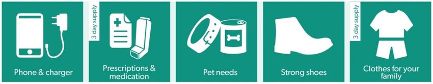
Local Flood Guide Hobsons Bay
Bureau of Meteorology Warnings
Warnings are issued by the Bureau of Meteorology (BoM) to tell people about possible flooding.
A Flood Watch means there is a developing weather pattern that might cause floods in one or two days. This
service covers the whole state.
A Flood Warning means flooding is about to happen or is already happening. There are minor, moderate and
major flood warnings. This service is only available where flood warning systems are in place.
A Minor Flood Warning A Moderate Flood Warning A Major Flood Warning
means floodwater can: means floodwater can: means floodwater can:
Spill over river banks and cover Spill over river banks and cover Cause widespread flooding.
nearby low lying areas. larger areas of land.
Come up through drains in nearby Reach above floor levels in some Many houses and businesses are
streets. houses and buildings. inundated above floor level.
Require the removal of stock in Require evacuation in some areas. Cause properties and whole areas
some cases. to be isolated by water.
Cover riverside camping areas Affect traffic routes. Closes major roads and rail routes.
and affect some low-lying caravan
parks.
Cover minor roads paths, tracks Require the removal of stock in Require many evacuations.
and low level bridges. rural areas.
Affect backyards and buildings Affect utility services (power,
below floor level. water, sewage etc).
Severe Thunderstorm Warnings
Thunderstorms are classified as severe when there is potential to cause significant localised damage through
wind gusts, large hail, tornadoes or flash flooding. Severe Thunderstorm Warnings are issued to the
community by BoM.
Severe Weather Warnings
These warnings are issued to the community by BoM when severe weather is expected that is not directly
related to severe thunderstorms or bushfires. Examples of severe weather include damaging winds and flash
flooding.
Flash Flooding
Flash Flooding can occur quickly due to heavy rainfall. You may not receive an official warning.
Stay informed- monitor weather warnings, forecasts and river levels at the BoM website and warnings
through VicEmergency.
Reviewed: 1 July 2020 5
Local Flood Guide Hobsons Bay
VICSES Warnings
VICSES utilises the VicEmergency app, website and hotline to distribute flood warnings and emergency
information in Victoria. Communities can also access this information through VICSES social media channels
and emergency broadcasters.
VICSES warnings aim to provide you with information to help you make good decisions to protect yourself
and your family
The warning level is based on severity, conditions and the likelihood that the emergency could impact on the
community.
WARNING LEVELS
EMERGENCY WARNING
You are in imminent danger and need to take action immediately. You will be impacted. A
Major flood warning usually fits into this category
WARNING (WATCH AND ACT)
An emergency is developing nearby. You need to take action now to protect yourself and
others. A Moderate flood warning usually fits into this category.
ADVICE
An incident is occurring or has occurred in the area. Access information and monitor
conditions.
Can also be used as a notification that activity in the area has subsided and is no longer a
danger to you. A Minor flood warning or Flood Watch usually fits into this category.
ADDITIONAL MESSAGES
PREPARE TO EVACUATE/ EVACUATE NOW
An evacuation is recommended or procedures are in place to evacuate.
COMMUNITY INFORMATION
A newsletter containing updates for communities affected by an emergency.
Can also be used as a notification that an incident has occurred but there is no threat to
community.
EMERGENCY ALERT
During some emergencies, we may alert communities by sounding a local siren, or by
sending an SMS to mobile phones or a voice message to landlines.
Your emergency plan
Emergencies can happen at any time and with little warning. People who plan and prepare for emergencies
can reduce the impact and recover faster.
Taking the time to think about emergencies and make your own plan helps you think clearly,, have more
control and make better decisions when an emergency occurs.
Visit redcross.org.au/prepare start creating your plan.
Remember, you may not receive any official warning.
Emergency assistance may not be immediately available.
Be aware of what is happening around you to stay safe.
Never wait for a warning to act.
Reviewed: 1 July 2020 6
Local Flood Guide            Hobsons Bay

Emergency Kit
Visit Emergency Toolkit for more information

Every home and business should have a basic emergency kit with supplies for 3 days:

Check your kit often. Make sure things work. Replace out of date items.

When a warning is issued, have ready for use or pack into your kit:
I need to add:
Write your list here. Tick items as you pack them into your kit.

Special needs (eg, babies, elderly
and people with a disability)

Photos
Family keepsakes
Valuables
Other

Reviewed: 1 July 2020                                                                 7
Local Flood Guide Hobsons Bay Emergency Checklist Check if your insurance policy covers flooding. Keep this list of emergency numbers in your mobile phone. Download the Vic Emergency app on your mobile phone. Put together an emergency kit and prepare a home or business. Emergency plan, see https://www.redcross.org.au/prepare Before Flooding Leaving early before flooding occurs is always the safest option. Evacuating through floodwater is very dangerous and you may be swept away. Stay informed- monitor weather warnings, forecasts and river levels at the http://www.bom.gov.au and warnings through www.emergency.vic.gov.au Secure objects likely to float and cause damage. Listen to the radio and check the VICSES website for information and advice. Go over your emergency plan. Pack clothing and other extra items into your emergency kit and take this with you if you evacuate. During Flooding Make sure your family members and neighbours are aware of what is happening. Conditions change rapidly; roads and escape routes can be covered or blocked. Put household valuables and electrical items as high as possible. Turn off water, gas and electricity at the mains. If you are staying in a caravan, move to higher ground before flooding begins. Seek shelter indoors, away from floodwater. If floodwater comes inside, move to a higher point such as a kitchen bench or second storey. Stay away from trees, drains, low-lying areas, creeks, canals, culverts and floodwater. Evacuating in Flooding Flood water is dangerous. Never enter floodwater. It can take just 15cm of water to float a car. Find alternative travel routes if roads or underpasses are flooded. Be aware of driving hazards, such as mud, debris, damaged roads and fallen trees. If driving conditions are dangerous, safely pull over away from trees, drains and floodwater. After Flooding For recovery information, contact your local council, go to the VicEmergency Relief and Recovery- emergency.vic.gov.au/Relief page or call the VicEmergency Hotline (1800 226 226). Have all electrical and gas equipment professionally tested before use. Stay away from damaged and flooded buildings, fallen trees and powerlines and damaged roads until authorities advise it is safe to do so. Drive slowly, obey all road signs and never drive through floodwater. When cleaning, protect your health and safety. Wear strong boots, gloves and protective clothing and wash your hands and clothes regularly. For VICSES emergency assistance, call 132 500, or Triple Zero (000) in life threatening emergencies. Reviewed: 1 July 2020 8
You can also read