Lilydale Local Flood Guide - Flood information for Lilydale in Yarra Ranges - Victoria State Emergency Service
←
→
Page content transcription
If your browser does not render page correctly, please read the page content below
Lilydale
                 Local Flood Guide
Flood information for Lilydale in Yarra Ranges

                        Lilydale

For flood emergency assistance call
VICSES on 132 500

Reviewed: 1 July 2020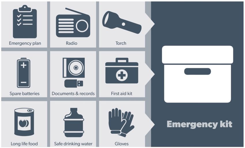
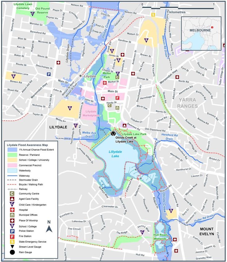
Local Flood Guide                  Lilydale

Lilydale
Lilydale is the gateway to both the Dandenong Ranges and the Yarra Valley. With 38 kilometres of recreation
trails as well as a mix of new urban cafes and restaurants, Lilydale is a popular destination to both live and
visit. Lilydale is located in the Yarra Ranges on the banks of the Olinda Creek. Olinda Creek flows from near
Mount Dandenong in Olinda through Lilydale, feeding into Lilydale Lake, and then continuing to flow north
where it meets the Yarra River at Yering. In addition to Lilydale Lake and the Olinda Creek, there are several
drains in the area which affect water flow during heavy rainfall.

The map below shows the impact of a 1% flood in the Lilydale area. A 1% flood means there is a 1% chance a
flood this size could happen in any given year. This map is provided as a guide to possible flooding in the
area.

Disclaimer
This map publication is presented by Victoria State Emergency Service for the purpose of disseminating emergency management
information. The contents of the information have not been independently verified by Victoria State Emergency Service. No liability is
accepted for any damage, loss or injury caused by errors or omissions in this information or for any action taken by any person in reliance
upon it. Flood information is provided by Melbourne Water

Reviewed: 1 July 2020                                                                                                                     2
Local Flood Guide Lilydale
Are you at risk of flood?
Lilydale Lake serves as a flood retarding basin for the area. Retarding basins are built to absorb and contain
flooding in periods of high rain, helping to lower the chances of damaging flooding in the area. While this helps
reduce the likelihood of damaging flooding in the area, parts of Lilydale can still be affected when heavy rain
falls over a short period of time, causing flash flooding. This can overwhelm the creek and drainage systems
and spill over into the surrounding area.
Flash flooding can occur with little warming, lasts only a short time but can leave severe damage in the local
area. During flash flooding, parts of Lilydale may experience isolation for short periods as roads become
inaccessible due to flood waters.
Roads that may be flooded in the area include:
Swansea Road Hightech Place Main Street service lanes (north
and south)
Akarnana Road Hull Road Morokai Grove
Beresford Road Industry Court Nelson Road
Cave Hill Road Industry Park Drive Quarry Road
Chapel Street John Street William Street East
No two floods are the same. Floods
Did you know? like this or worse could occur again.
The Yarra Ranges has a history of flooding with floods
recorded as early as 1891. Recent flooding in the Lilydale If you live in a low-lying area you may be at risk of
area include: flooding or need to detour around flooded areas.
In December 2016, flash flooding occurred across the Knowing what to do can save your life and help
Yarra Ranges due to a severe storm where 50 protect your property
millimetres of rain fell within a 16hour period and 15
millimetres within just 10 minutes. This amount of rain
overwhelmed gutters on a number of houses and
both Beresford and Hereford roads were flooded as
well as the Maroondah Highway.
During the 2011 storms, where Melbourne and surrounds experienced heavy rainfall, severe wind and
hail, flooding in Lilydale caused the closure of the Melba Highway.
On the 7th February 2002, Lilydale received the
equivalent of a month’s rainfall in just two hours.
During the flood, several houses were flooded and
roads were closed to traffic.
If you require assistance during a flood or storm,
contact SES on 132 500. Your local SES Lilydale Unit
will be able to assist you.
th
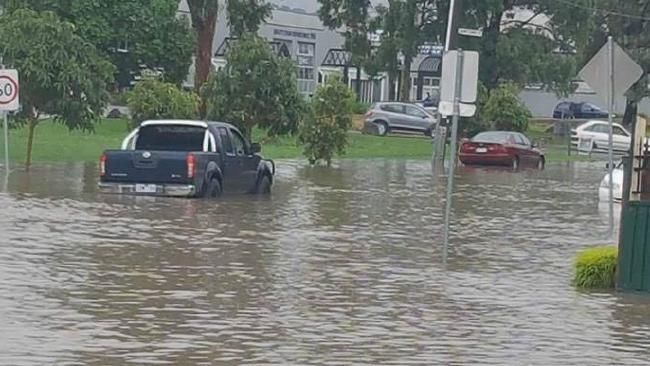
Beresford Road / Cave Hill Road, Lilydale. December 29 , 2016
Reviewed: 1 July 2020 3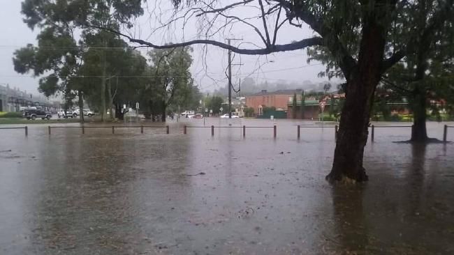
Local Flood Guide Lilydale
Staying Informed and Further Information
Current warnings (VicEmergency) emergency.vic.gov.au 1800 226 226
Bureau of Meteorology (BoM) bom.gov.au/vic/warnings 1300 659 217
VicRoads Traffic traffic.vicroads.vic.gov.au
Emergency Broadcasters ABC 774 Life-threatening
SKY NEWS Television Emergency
Yarra Valley 99.1FM 000
VICSES Social Media facebook.com/vicses
twitter.com/vicsesnews
SES Lilydale Unit facebook.com/LilydaleSES
Preparing for Flood Emergencies ses.vic.gov.au/get-ready
Creating an Emergency Plan redcross.org.au/prepare
Melbourne Water melbournewater.com.au 131 722
Yarra Ranges Council yarraranges.vic.gov.au 1300 368 333
Reviewed: 1 July 2020 4
Local Flood Guide Lilydale
Flood warnings and
emergency checklist
Bureau of Meteorology Warnings
Warnings are issued by the Bureau of Meteorology (BoM) to tell people about possible flooding.
A Flood Watch means there is a developing weather pattern that might cause floods in one or two days. This
service covers the whole state.
A Flood Warning means flooding is about to happen or is already happening. There are minor, moderate and
major flood warnings. This service is only available where flood warning systems are in place.
A Minor Flood Warning A Moderate Flood Warning A Major Flood Warning
means floodwater can: means floodwater can: means floodwater can:
Spill over river banks and cover Spill over river banks and cover Cause widespread flooding.
nearby low lying areas. larger areas of land.
Come up through drains in nearby Reach above floor levels in some Many houses and businesses are
streets. houses and buildings. inundated above floor level.
Require the removal of stock in Require evacuation in some areas. Cause properties and whole areas
some cases. to be isolated by water.
Cover riverside camping areas Affect traffic routes. Closes major roads and rail routes.
and affect some low-lying caravan
parks.
Cover minor roads paths, tracks Require the removal of stock in Require many evacuations.
and low level bridges. rural areas.
Affect backyards and buildings Affect utility services (power,
below floor level. water, sewage etc).
Severe Thunderstorm Warnings
Thunderstorms are classified as severe when there is potential to cause significant localised damage through
wind gusts, large hail, tornadoes or flash flooding. Severe Thunderstorm Warnings are issued to the
community by BoM.
Severe Weather Warnings
These warnings are issued to the community by BoM when severe weather is expected that is not directly
related to severe thunderstorms or bushfires. Examples of severe weather include damaging winds and flash
flooding.
Flash Flooding
Flash Flooding can occur quickly due to heavy rainfall. You may not receive an official warning.
Stay informed- monitor weather warnings, forecasts and river levels at the BoM website and warnings
through VicEmergency.
Reviewed: 1 July 2020 5
Local Flood Guide Lilydale
VICSES Warnings
VICSES utilises the VicEmergency app, website and hotline to distribute flood warnings and emergency
information in Victoria. Communities can also access this information through VICSES social media channels
and emergency broadcasters.
VICSES warnings aim to provide you with information to help you make good decisions to protect yourself
and your family
The warning level is based on severity, conditions and the likelihood that the emergency could impact on the
community.
WARNING LEVELS
EMERGENCY WARNING
You are in imminent danger and need to take action immediately. You will be impacted. A
Major flood warning usually fits into this category
WARNING (WATCH AND ACT)
An emergency is developing nearby. You need to take action now to protect yourself and
others. A Moderate flood warning usually fits into this category.
ADVICE
An incident is occurring or has occurred in the area. Access information and monitor
conditions.
Can also be used as a notification that activity in the area has subsided and is no longer a
danger to you. A Minor flood warning or Flood Watch usually fits into this category.
ADDITIONAL MESSAGES
PREPARE TO EVACUATE/ EVACUATE NOW
An evacuation is recommended or procedures are in place to evacuate.
COMMUNITY INFORMATION
A newsletter containing updates for communities affected by an emergency.
Can also be used as a notification that an incident has occurred but there is no threat to
community.
EMERGENCY ALERT
During some emergencies, we may alert communities by sounding a local siren, or by
sending an SMS to mobile phones or a voice message to landlines.
Your emergency plan
Emergencies can happen at any time and with little warning. People who plan and prepare for emergencies
can reduce the impact and recover faster.
Taking the time to think about emergencies and make your own plan helps you think clearly, have more
control and make better decisions when an emergency occurs.
Visit redcross.org.au/prepare start creating your plan.
Remember, you may not receive any official warning.
Emergency assistance may not be immediately available.
Be aware of what is happening around you to stay safe.
Never wait for a warning to act.
Reviewed: 1 July 2020 6
Local Flood Guide            Lilydale

Emergency Kit
Visit Emergency Toolkit for more information

Every home and business should have a basic emergency kit with supplies for 3 days:

Check your kit often. Make sure things work. Replace out of date items.

When a warning is issued, have ready for use or pack into your kit:
I need to add:
Write your list here. Tick items as you pack them into your kit.

Special needs (eg, babies, elderly
and people with a disability)

Photos
Family keepsakes
Valuables
Other

Reviewed: 1 July 2020                                                                 7
Local Flood Guide Lilydale Emergency Checklist Check if your insurance policy covers flooding. Keep this list of emergency numbers in your mobile phone. Download the Vic Emergency app on your mobile phone. Put together an emergency kit and prepare a home or business. Emergency plan, see https://www.redcross.org.au/prepare Before Flooding Leaving early before flooding occurs is always the safest option. Evacuating through floodwater is very dangerous and you may be swept away. Stay informed- monitor weather warnings, forecasts and river levels at the http://www.bom.gov.au and warnings through www.emergency.vic.gov.au Secure objects likely to float and cause damage. Listen to the radio and check the VICSES website for information and advice. Go over your emergency plan. Pack clothing and other extra items into your emergency kit and take this with you if you evacuate. During Flooding Make sure your family members and neighbours are aware of what is happening. Conditions change rapidly; roads and escape routes can be covered or blocked. Put household valuables and electrical items as high as possible. Turn off water, gas and electricity at the mains. If you are staying in a caravan, move to higher ground before flooding begins. Seek shelter indoors, away from floodwater. If floodwater comes inside, move to a higher point such as a kitchen bench or second storey. Stay away from trees, drains, low-lying areas, creeks, canals, culverts and floodwater. Evacuating in Flooding Flood water is dangerous. Never enter floodwater. It can take just 15cm of water to float a car. Find alternative travel routes if roads or underpasses are flooded. Be aware of driving hazards, such as mud, debris, damaged roads and fallen trees. If driving conditions are dangerous, safely pull over away from trees, drains and floodwater. After Flooding For recovery information, contact your local council, go to the VicEmergency Relief and Recovery- emergency.vic.gov.au/Relief page or call the VicEmergency Hotline (1800 226 226). Have all electrical and gas equipment professionally tested before use. Stay away from damaged and flooded buildings, fallen trees and powerlines and damaged roads until authorities advise it is safe to do so. Drive slowly, obey all road signs and never drive through floodwater. When cleaning, protect your health and safety. Wear strong boots, gloves and protective clothing and wash your hands and clothes regularly. For VICSES emergency assistance, call 132 500, or Triple Zero (000) in life threatening emergencies. Reviewed: 1 July 2020 8
You can also read