Wickliffe Local Flood Guide - For flood emergency help call VICSES on 132 500 - Victoria State Emergency Service
←
→
Page content transcription
If your browser does not render page correctly, please read the page content below
Wickliffe
               Local Flood Guide
               Flood information for the Hopkins River at Wickliffe

                                                                      January 2011

            Wickliffe

For flood emergency help call
VICSES on 132 500

   Reviewed: June 2021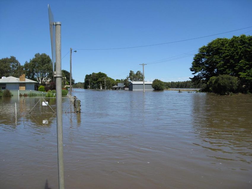
Local Flood Guide Wickliffe
Wickliffe
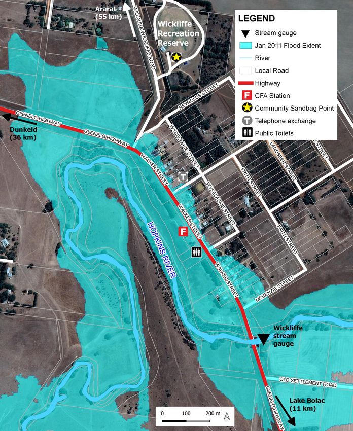
Wickliffe is located in Central Victoria in the municipality of Ararat Rural City Council, approximately 50
kilometres south of Ararat. Wickliffe homes and businesses located within the floodplain of the Hopkins
River were flooded in January 2011. The map below shows the extent of the January 2011 Hopkins
River flood in Wickliffe, which measured 5.89 metres on the Wickliffe stream gauge.
Disclaimer: this map by Victoria State Emergency Service for the purpose of disseminating emergency management information. The contents of the
information has not been independently verified by Victoria State Emergency Service. No liability is accepted for any damage, loss or injury caused by errors or
omissions in this information. Flood risk information is provided by Glenelg Hopkins Catchment Management Authority.
2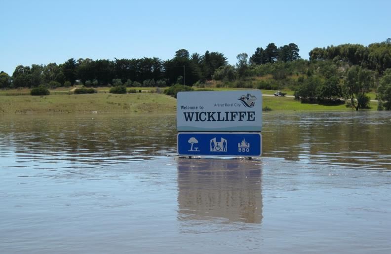
Local Flood Guide            Wickliffe

Are you at risk of flooding?
The area surrounding Wickliffe is generally flat, cleared,
agricultural land drained by the Hopkins River. The
western upland area near Ararat and the south eastern
ranges of the Grampians National Park drains into the
Hopkins River north of Wickliffe. The Hopkins River
begins north east of Ararat, then flows south through
Wickliffe.

Wickliffe generally floods due to heavy rainfall
upstream. When flooding occurs in Wickliffe, homes,
businesses and buildings in Walker Street are most at
risk. Floodwater rises very quickly in Wickliffe, houses
can be impacted by flooding within 24 after heavy                           Wickliffe, January 2011
rainfall. Floodwater can remain high for two days before
receding.

Did you know?
Wickliffe has a history of flooding, significant flood events have occurred in 1909, 1960, 1964, 1973,
1974, 1975, 1981, 1983, 1984, 1986, 1988 and 2011. In January, 2011, Wickliffe experienced its
largest ever flood when the catchment received 112 to 172 millimetres of rainfall over four days. The
flood level recorded for this flood event was 5.89 metres.

▪     It took approximately 24 hours for floodwater to travel from Ararat to Wickliffe.
▪     The Glenelg Highway was closed at Wickliffe for two days.
▪     Eleven buildings were inundated above floor, including the Wickliffe Hotel.
▪     The Wickliffe stream gauge peak (highest recorded river level) was 5.89 metres.
▪     Further upstream, the Ararat stream gauge peaked at 3.56 metres.

Staying Informed and Further Information
▪   Current warnings (VicEmergency)           emergency.vic.gov.au             1800 226 226
▪   Bureau of Meteorology (BoM)               bom.gov.au/vic/warnings          1300 659 217
▪   VicRoads Traffic                          traffic.vicroads.vic.gov.au
▪   Emergency Broadcasters                    ABC 94.1 FM
                                              3HA 981 AM
                                              Mixx 88.9 FM
                                              SKY NEWS Television
                                                                                 Life-threatening
                                                                                    Emergency
▪   VICSES Social Media                       facebook.com/vicses
                                                                                        000
                                              twitter.com/vicsesnews
▪   Preparing for Flood Emergencies           ses.vic.gov.au/get-ready
▪   Creating an Emergency Plan                redcross.org.au/prepare
▪   Catchment Management Authority            https://www.ghcma.vic.gov.au/ (03) 5571 2526
▪   Ararat Rural City Council                 www.ararat.vic.gov.au            (03) 5355 0200

▪   National Relay Service (NRS)              relayservice.gov.au

                                                                                                         3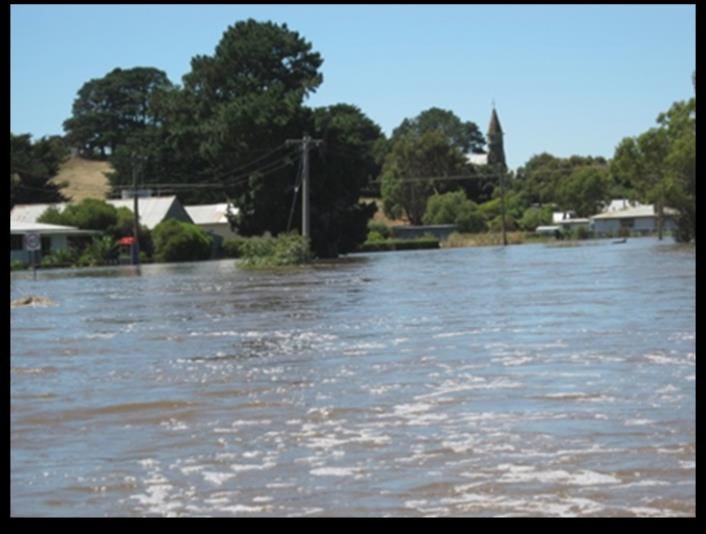
Local Flood Guide             Wickliffe

Hopkins River flood levels at Wickliffe

Wickliffe generally floods due to heavy rainfall upstream, surrounding Ararat and the eastern ranges of the
Grampians National Park.

    There are four rainfall/river stream gauges within the Wickliffe area, these include:
        ▪   Rainfall gauge located at Mt William
        ▪   Rainfall gauge located at Willaura
        ▪   River height and rainfall gauge on the Hopkins River at Ararat
        ▪   River height gauge on the Hopkins River at Wickliffe

    Monitoring these rainfall and stream gauges will provide early clues of possible flooding. The Bureau of
    Meteorology (BoM) does not issue river height predictions for Wickliffe. To monitor the Wickliffe stream gauge
    height go to the BoM website bom.gov.au/vic/flood/

▪    Select ‘River
     Conditions’ (above
     the map)
▪    Click on Glenelg
     Hopkins on the
     right.
▪    Find the Wickliffe
     (Hopkins River)
     gauge and hover
     over it.
▪    Compare river
     height to the stream
     gauge heights on the
     table below to
     determine if
     flooding is likely.

                                                                                                                 4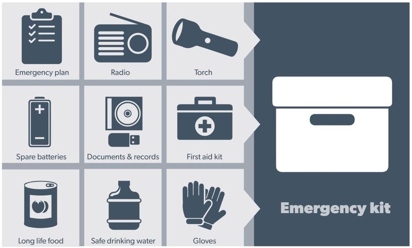
Local Flood Guide            Wickliffe

  The table below provides an indication of what you can expect at certain Wickliffe stream gauge heights,
  including when your access may be cut off and when your property may be affected.

 Wickliffe
 Stream Gauge       Flood Impact
 Height (metres)
 5.89 m             January, 2011 flood level (flood extent shown on map page 2)
                    11 buildings were flooded above floor including the Wickliffe Hotel and Cookie’s Old
                    Store.

 5.88 m             6 buildings are flooded above floor in Walker Street. The Glenelg Highway bridge, south
                    side of Wickliffe is close to being overtopped.

 5.58 m             3 buildings are flooded above floor, including the CFA Station. Flooding impacts 9
                    properties.

 5.30 m             Proposed Major flood level

 5.18 m             Two properties in Walker Street start to be impacted by flooding. No buildings are
                    impacted by flooding above floor. The Glenelg Highway and Walker Street is
                    impassable to traffic to the north of Wickliffe, flood depth up to 0.5m.

 5.00 m             Proposed Moderate flood level

 4.48 m             Shallow flooding overtops the Glenelg Highway to a depth up to 0.15m.

 4.40 m             Proposed Minor flood level

 4.39 m             October 1986 flood event.

 4.13 m             August 1992 flood event.

                                                                    Sandbag Collection Point

                                                                    A Sandbag Collection Point may be
                                                                    opened at the Wickliffe Recreation
                                                                    Reserve, 1755 Willaura-Wickliffe Road,
                                                                    if there is potential for flooding in the
                                                                    area.

                                                                    Residents can call in to fill and collect
                                                                    sandbags to protect your home.

                                                                    Ararat Rural City Council will promote
                                                                    when this collection point is opened
                                                                    through local radio and other media.
Wickliffe, January 2011

                                                                                                                5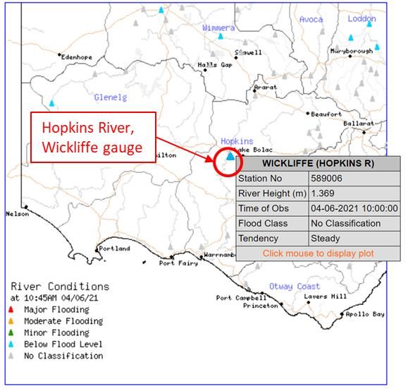
Flood warnings and
                        emergency checklist

Bureau of Meteorology Warnings
Warnings are issued by the Bureau of Meteorology (BoM) to tell people about possible flooding.

A Flood Watch means there is a developing weather pattern that might cause floods in one or two days. This
service covers the whole state.

A Flood Warning means flooding is about to happen or is already happening. There are minor, moderate and
major flood warnings. This service is only available where flood warning systems are in place.

         A Minor Flood Warning means                 A Moderate Flood Warning                A Major Flood Warning means
         floodwater can:                             means floodwater can:                   floodwater can:

  Spill over river banks and cover nearby   Spill over river banks and cover larger   Cause widespread flooding.
  low lying areas.                          areas of land.

  Come up through drains in nearby          Reach above floor levels in some          Many houses and businesses are
  streets.                                  houses and buildings.                     inundated above floor level.

  Require the removal of stock in some      Require evacuation in some areas.         Cause properties and whole areas to be
  cases.                                                                              isolated by water.

  Cover riverside camping areas and         Affect traffic routes.                    Closes major roads and rail routes.
  affect some low-lying caravan parks.

  Cover minor roads paths, tracks and       Require the removal of stock in rural     Require many evacuations.
  low level bridges.                        areas.

  Affect backyards and buildings below                                                Affect utility services (power, water,
                                                                                      sewage etc).
  floor level.

Severe Thunderstorm Warnings

Thunderstorms are classified as severe when there is potential to cause significant localised damage through
wind gusts, large hail, tornadoes or flash flooding. Severe Thunderstorm Warnings are issued to the community
by BoM.

Severe Weather Warnings

These warnings are issued to the community by BoM when severe weather is expected that is not directly related
to severe thunderstorms or bushfires. Examples of severe weather include damaging winds and flash flooding.

Flash Flooding

▪ Flash Flooding can occur quickly sue to heavy rainfall. You may not receive an official warning.

▪ Stay informed- monitor weather warnings, forecasts and river levels at the BoM website and warnings through
  VicEmergency.

   Reviewed: June 2021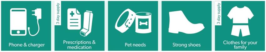
Local Flood Guide           Wickliffe

VICSES Warnings
VICSES utilises the VicEmergency app, website and hotline to distribute flood warnings and emergency
information in Victoria. You can also access this information through our social media channels and emergency
broadcasters.

VICSES warnings aim to provide you with information to help you make good decisions to protect yourself and
your family.

The warning level is based on severity, conditions and the likelihood of community impact.

  WARNING LEVELS
                    EMERGENCY WARNING
                    You are in imminent danger and need to take action immediately. You will be
                    impacted. A Major flood warning usually fits into this category.
                    WARNING (WATCH AND ACT)
                    An emergency is developing nearby. You need to take action now to protect yourself
                    and others. A Moderate flood warning usually fits into this category.
                    ADVICE
                    An incident is occurring or has occurred in the area. Access information and monitor
                    conditions. Can also be used as a notification that activity in the area has subsided
                    and is no longer a danger to you. A Minor flood warning or Flood Watch usually fits
                    into this category.

  ADDITIONAL MESSAGES
                    PREPARE TO EVACUATE/ EVACUATE NOW
                    An evacuation is recommended or procedures are in place to evacuate.

                    COMMUNITY INFORMATION
                    Updates for communities affected by an emergency.
                    Can also be used as a notification that an incident has occurred but there is no threat
                    to community.
                    EMERGENCY ALERT
                    During some emergencies, communities may be alerted by the sounding of a local
                    siren, or by sending an SMS to mobile phones or a voice message to landlines.

Your emergency plan
Emergencies can happen at any time, with little warning. People who plan and prepare for emergencies reduce
the impact and recover faster.

Taking the time to think about emergencies and make your own plan helps you think clearly and have more
control to make better decisions when an emergency occurs.

Visit redcross.org.au/prepare start creating your plan.

  ▪    Remember, you may not receive any official warning.
  ▪    Emergency assistance may not be immediately available. Be aware of what is happening
       around you to stay safe.
  ▪    Never wait for a warning to act.

                                                                                                                7
Local Flood Guide Wickliffe
Emergency Kit
Visit Emergency Toolkit for more information
Every home and business should have a basic emergency kit with a supply of 3 days:
Check your kit often. Make sure things work. Replace out of date items.
When a warning is issued, have ready for use or pack into your kit:
I need to add:
Write your list here. Tick items as you pack them into your kit
Special needs (eg, babies,
Elderly)
Photos
Family keepsakes
Valuables
Other
8Local Flood Guide Wickliffe
Emergency Checklist
Check if your insurance policy covers flooding.
Keep this list of emergency numbers in your mobile phone
Download the Vic Emergency app on your mobile phone.
Put together an emergency kit and prepare a home or business emergency plan, see
redcross.org.au/prepare
Before Flooding
Leaving early before flooding occurs is always the safest option. Evacuating through
floodwater is very dangerous and you may be swept away.
Stay informed- monitor weather warnings, forecasts and river levels at bom.vic.gov.au and warnings
through emergency.vic.gov.au.
Secure objects likely to float and cause damage.
Listen to the radio and check the VICSES website for information and advice.
Go over your emergency plan. Pack clothing and other extra items into your emergency kit and take
this with you if you evacuate.
If you are staying in a caravan, move to higher ground before flooding begins.
During Flooding
Make sure your family members and neighbours are aware of what is happening.
Conditions change rapidly; roads and escape routes can be covered or blocked.
Put household valuables and electrical items as high as possible.
Turn off water, gas and electricity at the mains.
Seek shelter indoors, away from floodwater.
If floodwater comes inside, move to a higher point such as a kitchen bench or second storey.
Stay away from trees, drains, low-lying areas, creeks, canals, culverts and floodwater.
Evacuating in Flooding
Flood water is dangerous. Stay safe by never entering flood water. It can take just 15cm of
water to float a car.
Find alternative travel routes if roads or underpasses are flooded.
Be aware of driving hazards, such as mud, debris, damaged roads and fallen trees. If driving
conditions are dangerous, safely pull over away from trees, drains and floodwater.
After Flooding
For recovery information, contact your local council, go to the VicEmergency Relief and Recovery-
emergency.vic.gov.au/Relief page or call the VicEmergency Hotline (1800 226 226).
Have all electrical and gas equipment professionally tested before use.
Stay away from damaged and flooded buildings, fallen trees and powerlines, and damaged roads.
Drive slowly, obey all road signs and never drive through floodwater.
When cleaning, protect your health and safety. Wear strong boots, gloves and protective clothing.
For VICSES emergency assistance, call 132 500, or Triple Zero
(000) in life threatening emergencies.
9You can also read