NEW FOR 2021: 'GLAMPING' OPPORTUNTIES - Unita - Wasatch - Cache National Forest Ogden Ranger District Recreation Update - Forest Service
←
→
Page content transcription
If your browser does not render page correctly, please read the page content below
Ogden Ranger District Update: 01.21.21                                                Page |1

                        Unita – Wasatch – Cache National Forest
                        Ogden Ranger District Recreation Update
                        507 25th Street, Ogden, UT 84401
                        Hours: Monday — Friday, 8:00 a.m. — 4:30 p.m.
                        (Closed Weekends and Federal Holidays)

Forest Maps and America the Beautiful passes are available at the Ogden Ranger District (ORD)
office located two blocks uphill from Washington Blvd on the corner of 25th and Adams. For
more information call us at 801‐625‐5112 or visit the Forest website www.fs.usda.gov/uwcnf.

                Campgrounds, Day Use areas and seasonal gates ARE CLOSED

      NEW FOR 2021: ‘GLAMPING’ OPPORTUNTIES
 Campground reservations can currently be made at Recreation.gov for late May to Mid‐July

General Information
The Utah Recreation Company (URC) manages the onsite
camping, boat launching, storage and rental stations for the
area. You may reach them at 385‐273‐1100. Cemetery
Point, Anderson Cove, and Port Ramp Marina boat launch
facilities are also managed by URC ‐ all seasonal and weekly
passes can be purchased from them directly. Please note,
during high operation season No America The Beautiful Pass’
are valid for fee day use areas and campgrounds. Only the
Access and Senior Passes are honored for discounted single
campsites only.

Camping and Reservations
Reservations for camping are allowed for individual/double
and group sites and our new Glamorous camping units; all campsites can be reserved six
months prior but not less than five days in advance. If sites are not reserved five days in
advance, the site will be available as a first‐come first serve site. Group reservations can be
made for Anderson Cove, Perception Park and Monte Cristo campgrounds up to one year in
advance. SENIOR and ACCESS Interagency Passes are NOT valid for GROUP or DOUBLE sites;
only SINGLE sites are covered – and only for the individual with the Senior/Access pass, who
must be onsite to use the discount privilege; and day‐use (swimming, boat launch, picnic, etc.)
is not discounted. You can schedule day use activities and camping reservations through
Recreation.gov or by calling 1‐877‐444‐6777.
Ogden Ranger District Update: 01.21.21 Page |2
Things to Note
Port Ramp is open all year, with fees only when occupied (in summer months) when hosts are onsite.
Pineview Reservoir Weekly and Season Boat Launch passes are sold by a concessionaire.
No glass containers of any short are allowed at: Port Ramp, Cemetery Point, Cemetery Point Marina,
Middle Inlet, Anderson Cove, Pineview and any other beach areas.
No Dogs allowed on any Pineview beach area. They are allowed at your campsite areas. Please always
have your leash with you.
No Grills of any kind on the beach, you must use the designated picnic grill areas.
Campgrounds CLOSED FOR SEASON – FEES LISTED ARE SUBJECT TO CHANGE FOR 2021
You can reserve a spot 5 days in advance or sooner through Recreation.gov, 877‐444‐6777
Operation hours: 6AM – 10PM Check‐In time: 3:00PM Check‐Out time: 12:00PM
Name Nightly 2nd Vehicle Capacity Open/
Fee Fee Closed
Anderson Cove Higher standard, 8 Hosts CLOSED
(Elevation 5000)
Singles $28 $10 58 units CLOSED
Doubles $55 $10 9 units CLOSED
Tent Sites $22 $10 Near beach parking area CLOSED
Group Sites+ $255 $10 after 20 Ashley, Bonneville, Cache, CLOSED
vehicles Trapper, Douglas (100 people)
**GLAMPING SITES $133 $10 16 single sites available, 2 night CLOSED
requirement
Botts $24/ $10 6 single, 1 double, no host CLOSED
(Elevation 5200) $46
Lower Meadow $24/ $10 19 single, 6 double, host CLOSED
(Elevation 5200) $46
Magpie $24/ $10 7 single, 2 double, host CLOSED
(Elevation 5200) $46
Monte Cristo $24 $10 45 units, paved, host CLOSED
(Elevation 5400) 9/11
Group Sites+ $210 $10 Sites 26 and 27, 100 people each CLOSED
Perception Park $24/ $10 24 units, paved, host CLOSED
(Elevation 5200) $46
Group Sites+ $235 $10 per McKay‐ 80 people, GFWC‐ 60 CLOSED
vehicle after people, WCCU‐ 60 people
20 vehicles
South Fork $24/ $10 35 single, 8 double, host CLOSED
(Elevation 5200) $46
Upper Meadows $24/ $10 9 units, no host CLOSED
(Elevation 5200) $46
Willows $24/ $10 12 single, 3 double, host CLOSED
(Elevation 5200) $46
Ogden Ranger District Update: 01.21.21                                                Page |3
 Day Use Areas
            Area Name                      Fee              Comments                 Open/
                                                                                     Closed
 Anderson Cove Picnic ground            $18      Per vehicle                      CLOSED
 Cemetery Point Marina                  $18      Per vehicle                      CLOSED
 Cemetery Point Picnic ground           $18      Per vehicle                      CLOSED
 Middle Inlet Picnic ground             $18      Per vehicle                      CLOSED
 Middle Inlet – Amelia Tent Day Use     $133     2 vehicles included, $10         CLOSED
                                                 additional, occupancy 16.
                                                 6 units available.
 Port Ramp Marina                       $18      Per vehicle, no fee in        OPEN
                                                 winter months
 Perception Park Picnic ground          $12      13 picnic tables              CLOSED
 Anderson Cove Dump Station             $10      Fee for all non‐camping       CLOSED
                                                 and camping customers
 SEASON/WEEKLY Day Use Pass for         $155/$75 Does not apply to boat launching;
 Pineview Reservoir                              purchase on site
 Walk‐in/Other Day use Fee              $10      Per person
 DAY USE Boat Launch                    $19      Per vessel, purchase on site
 SEASON/WEEKLY pass ‐                   $155/$75 Per vessel‐ ramp only, not valid for day
 Pineview Reservoir Boat Launch                  use; purchase on site
 Port Ramp Boat Slip                             Port Ramp is open all year, with fees only
 Not available for the 2021 season               when hosts are on site.

GLAMPING
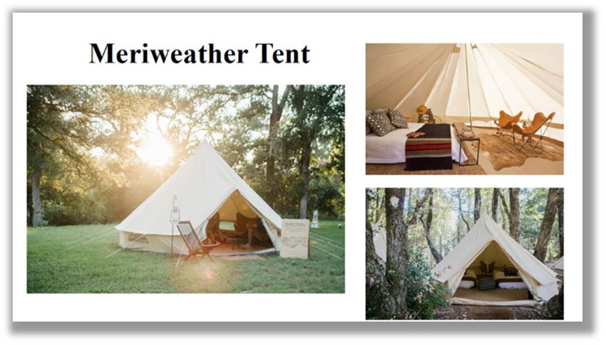
Glamorous camping units “Glamping”
are high amenity lodging units –
Meriweather Tents are soft‐sided tents
placed at already existing sites at
selected locations. These units will be
provided starting the summer of 2021,
available for reservation on
Recreation.gov. No first come first serve
units will be available unless reservations are not made. Reservation minimum of 2 nights and
3 nights for Holiday weekends.

What is provided: Canvas tent with 2 queen size beds, a chair, ottoman, lanterns, indoor and
outdoor rugs, and outdoor chairs. Linens will not be included; campers will have to bring their
sleeping bags or bedding. Campers will also have access to the fire ring and picnic table
included with the site and access to the amenities of the campground.
Occupancy: The maximum occupancy of the single site is 4 people per single tent. Check‐in time
is 3 pm and Check OUT time is 12 pm. Site rental includes 1 vehicle per single campsite.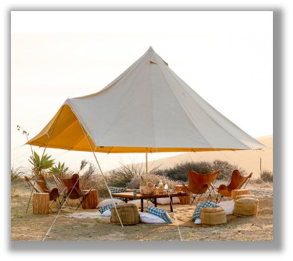
Ogden Ranger District Update: 01.21.21 Page |4
Additional vehicles will be charged EXTRA VEHICLE FEE $10.00 per day per vehicle. Additional
tents or trailers are not allowed at the glamping sites.
Price per single site, single‐unit/night $ 133.00 (We currently do not officer double site units)
(Sites listed for Glamping reservation only: 86 to 91 and 103 to 112)
GLAMPING – DAY USE ONLY
Amelia day use tents will be used for Day Use only at Middle Inlet
to provide increased amenities. The maximum occupancy of the
tent is 16 people, however specific site occupancy will dictate the
maximum number of visitors per site. Check‐in time is 10 am and
Check OUT time is 9 pm. Site rental includes 2 vehicles per
reservation. Additional vehicles will be charged EXTRA VEHICLE
FEE $10.00 per day per vehicle. Additional tents or trailers are
not allowed at the glamping sites. All units will be available for
reservations through Recreation.gov.
No FCFS units will be available unless reservations are not made 5 days in advance.
Price per unit/day $ 133.00
Dispersed Camping
Dispersed camping does not provide you with any type of services or facilities. It’s just you and
the woods. Dispersed camping not quite as simple as driving up to the woods and pitching a
tent. There’s a handful of rules and regulations that go along with dispersed camping. Here are
a few examples of dispersed camping rules.
You must camp at least 200 feet from streams,
lakes, rivers, and other bodies of water.
You must camp at least 300 feet from
developed roads and trails.
You may not camp or leave any equipment at
the same location for more than 14
consecutive days within a 30‐day period.
You may not camp near to established
recreation areas (trailheads, maintained
campgrounds, other developed areas, etc.)
You may not camp in meadows or clearings (you’re not wildlife, so stay out of sight!)
It’s important to research an area before you head there. Check for things like burn bans, what
type of wildlife you might encounter, whether it’s hunting or mating season, what to do if you
encounter wildlife, etc. Refer to Motor Vehicle Map for areas that allow dispersed camping.
Ogden Ranger District Update: 01.21.21                                                    Page |5

Pack it in, pack it out, and practice the Leave No Trace principles (meaning make it look like you
were never there and take all your trash with you). Make efforts to camp in locations that have
been used before. This will help limit your impact on the environment.
Roads and Gates
Forest roads and gates on the Ogden Ranger District (ORD) close in the fall for road surface
protection. The Motor Vehicle Use Map (MVUM) shows the earliest date a road will open to
motorized travel in the spring and the date a road will close in the fall. You can find this map at
www.fs.usda/uwcnf click on maps and publications link and refer to the ORD MVUM.
Please contact Box Elder County Roads Department (435‐257‐5450), Weber County Roads
Department (801‐399‐8440) and/or Cache County Roads Department (435‐755‐1560) for gates
they may manage. Refer to UDOT for state seasonal road closures in the area:
https://udottraffic.utah.gov
Monte Cristo and Wheatgrass Roads

State Route 39 Monte Cristo      CLOSED Managed by State, check UDOT for current date openings,
                                 tentative opening Mid‐May to Mid‐November

Dairy Ridge                      Depends on SR 39 opening date, tentative open June 1; closed Nov 15

Dry Bread Hollow/Pond            Depends on SR 39 opening date, tentative open June 1; closed Nov 15

Wasatch Ridge                    Depends on SR 39 opening date, tentative open June 1; closed Nov 15

Curtis Creek Roads

Baxter Sawmill                   Depends on SR 39 opening date, tentative open June 1; closed Nov 15

Curtis Ridge                     Depends on SR 39 opening date, tentative open June 1; closed Nov 15

Old Canyon                       Depends on SR 39 opening date, tentative open June 1; closed Nov 15

New Canyon                       Depends on SR 39 opening date, tentative open June 1; closed Nov 15

South Fork Roads

Causey Road                      OPEN, managed by Weber County

Ogden Front and Pineview Reservoir Roads

State Road 167                   Managed by State, check UDOT for current dates openings, tentative
                                 opening late May to Mid‐November

State Road 226                   CLOSED, at Art Nord, NO access to Snow Basin;
                                 Managed my State, Always OPEN

Willard and Public Grove Roads
Ogden Ranger District Update: 01.21.21 Page |6
Avon‐ Liberty Lower Gates managed by Weber and Cache County, check with County
for correct dates, tentative open Mid‐May, closed Mid‐Nov.
Dock Flat (Willard Peak Road) Lower gate managed by Box Elder County, check with county for opening
dates, FS 6029 will open in correlation.
Public Grove (ATV FS 6020) OPEN JUNE 15, CLOSED NOV 15
Willard Basin (FS 084, to OPEN JULY 15, CLOSED NOV 15
Inspiration Point)
Three Mile OPEN JULY 15, CLOSED NOV. 15
Baldy Peak Road OPEN JUNE 1, CLOSED SEPT. 15
(FR 071 and 708)
Trails and Forest Routes – Refer to MVUM for Route Special Vehicle Designations
Skyline North Trail (002) OPEN JULY 15, CLOSED NOV. 15
FR 001, 090 OPEN JULY 15, CLOSED NOV. 15
FR 012 OPEN JULY 15, CLOSED NOV. 15
FR 113, 994, 033‐A OPEN JUNE 15, CLOSED NOV. 15
FR 6029 OPEN JUNE 15, CLOSED NOV. 15
Firearms and Shooting Areas (And Hunting)
Both State and Federal laws apply to the Forest, please check the counties ordinances that may
apply to the area you will be visiting. You also need to follow any general federal laws and
regulations about weapons. The only regulations specific to use of weapons imposed by the
Forest Service is that you cannot discharge a weapon within 150 yards of any
structure/development and other occupied area, within or into a cave, across or on a road or
body of water or trail or in any manner that endangers a person. You also can not use any
tracer or incendiary ammunition. Forest Service regulations require that you comply with all
State laws regarding the use of firearms while hunting. We encourage you to use designed
shooting areas or ranges. However, if you choose to shoot in an undersigned areas please
ensure that your shooting does not damage any facilities, signs, natural resources, disrupt other
uses, or endanger public safety, and be sure you removed any targets, wads, shells, brass and
other refuse with you when you leave. Be sure your shooting target is free of rocks, as wildfires
have resulted from sparks of ricochets.
Firewood Permits
Firewood permits are currently not available for the 2021 season. Permits are valid for one
season and allow you to collect dead and down wood only, in designated areas.Ogden Ranger District Update: 01.21.21 Page |7 SAFTEY, FIRE, WEATHER INFORMATION: The Forest does not have a fire restriction in place at this time. Please Go to UtahFireInfo.gov for the most recent Utah fire activity and updates. To Report a Wildfire, CALL 911 ‐OR‐ For a wildfire in a remote location contact the Northern Utah Interagency Fire Center (NUIFC): (801) 495‐7611 As snow starts to accumulate in the Utah Backcountry, it’s a good idea to tone it down and remember: Avoid going too fast, maintain control, and be conservative; Stick to smooth, grassy, low‐angled slopes; Stay off steep slopes. Remember the old adage, “If there's enough snow to ride, there's enough snow to slide.” Even a very small, early season avalanche can be very dangerous if you are caught carried over rocks or raked through bushes and stumps. As snow falls, the Utah Avalanche Center will begin issuing regular avalanche forecasts and danger ratings across the state you can reference to at www.utahavalanchecenter.org.
You can also read


