Milestone 10 - Report Market consultation on new technology, products and policy measures
←
→
Page content transcription
If your browser does not render page correctly, please read the page content below
Milestone 10 – Report
Market consultation on new
technology, products and
policy measures
Authors: WSP Sweden
Date: 29 February 2020

     This project has received funding   The sole responsibility for the content of this
     from the European Union’s           document lies with the authors. It does not
     Horizon 2020 research and           necessarily reflect the opinion of the European
     innovation programme under          Union. Neither INEA nor the European Commission
     grant agreement No 815069.          are responsible for any use that may be made of
                                         the information contained therein.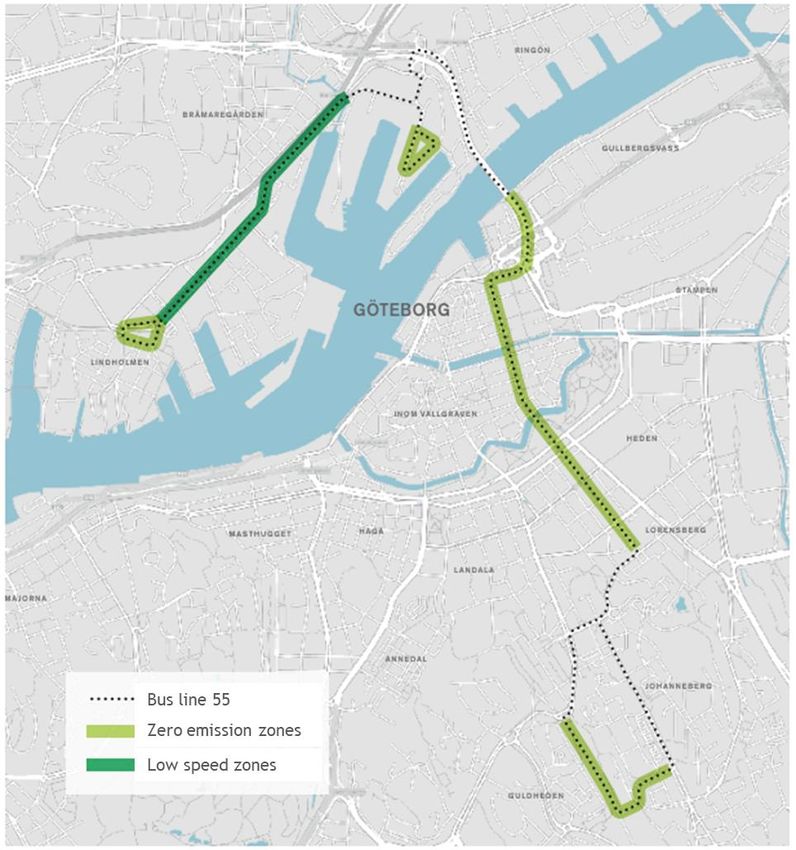
Table of Contents
Summary sheet ................................................................................................................................................................ 3

About ReVeAL ................................................................................................................................................................. 4

Description of milestone ................................................................................................................................................... 5

Method ............................................................................................................................................................................. 6

Results ............................................................................................................................................................................. 9

    Description of future UVARs and related technologies ................................................................................................ 9

    General results from the survey ................................................................................................................................. 11

    Geofencing................................................................................................................................................................. 13

    Future pricing measures ............................................................................................................................................ 18

    New types of ITS measures ....................................................................................................................................... 19

    Dynamic kerbside or parking management ................................................................................................................ 22

    Rewarding high-occupancy vehicles .......................................................................................................................... 23

    Legal framework ........................................................................................................................................................ 24

Conclusions.................................................................................................................................................................... 27

References ..................................................................................................................................................................... 29

    Interviews ................................................................................................................................................................... 29

    Written sources .......................................................................................................................................................... 29

    Respondents to the survey ........................................................................................................................................ 30

Appendix: Market consultation survey ............................................................................................................................ 32

                                                                               Milestone 10:
Copyright © 2019 by ReVeAL                                                     Consultation Report                                                                 Page 2 of 38
Summary sheet
Milestone No. 10
Project Acronym ReVeAL
Full Title Regulating Vehicle Access for improved Liveability
Grant Agreement No. 815008
Responsible Author(s) Moa Berglund and Ylva Berner, WSP Sweden
Peer Review Dirk van Amelsfort, WSP Sweden
Date February 28, 2020
Status Final
Work Package No. 2
Work Package Title Reviewing UVAR options and building scenarios
Programme Horizon 2020
Coordinator City of Bielefeld
Website Civitas-reveal.eu
Starting date 01 June 2019
Number of months 36
Milestone 10:
Copyright © 2019 by ReVeAL Consultation Report Page 3 of 38About ReVeAL
ReVeAL – Regulating Vehicle Access for Improved Liveability – is a CIVITAS project funded by the
European Union’s Horizon 2020 research and innovation programme. The goal of ReVeAL is to add
Urban Vehicle Access Regulations (UVAR) to the standard range of urban mobility transition
approaches of cities across Europe. The EU funded R&I ReVeAL project looks at this hot topic for
the first time since the CURACAO project (ending a decade ago).
The overarching mission of the project is to enable cities to optimise urban space and transport
network usage through new and integrated packages of urban vehicle access policies and
technologies. Such policies can lead to fewer emissions, less noise and improved accessibility and
quality of life, which especially benefits the people living in these cities. These policies can also
encourage more sustainable transport choices, enabling cities to become more liveable, ultimately
healthier and more attractive for every member of society.
To this end, ReVeAL combines conceptual work and case study research with hands-on UVAR
implementation in six pilot cities, as well as systematic stakeholder interaction through
professional communication activities. Different UVAR measures will be developed, implemented
and tested in the cities of: Helmond (NL), Jerusalem (IL), London (UK), Padova (IT), Vitoria-Gasteiz
(ES) and the project leader Bielefeld (DE). Except these cities, the project partners are Centro de
Estudios Ambientes (ES), Ghent University (BE), Universitá di Padova (IT), POLIS (BE), Rupprecht
Consult (DE), Sadler Consultants (DE), Transport for London (UK), TRT (IT), V-Tron (NL) and WSP
Sweden (SE). The project started in June 2019 and will run for three years.
ReVeAL looks at a range of UVAR measures, both established and cutting-edge approaches,
grouped under the four Measure Fields:
Zero-emission zones
Areas where only vehicles emitting zero emissions are permitted.
Spatial interventions
Access regulations based on area planning and design, and physical
interventions in the public realm.
Pricing measures
Financial charging for accessing specific areas.
Future proofing and future options
Possible tools and emerging technologies that cut across all measures.
Milestone 10:
Copyright © 2019 by ReVeAL Consultation Report Page 4 of 38Description of milestone
Milestone 10 is part of task 2.6 – Future proofing UVARs which is the main activity of the measure
field Future proofing and future options. This task is carried out in two parts:
1. Innovation Observatory report and city-specific readiness assessment: The observatory will
cover both mobility products and services (their market penetration and potential
transportation and societal impacts) as well as the potential of new technology (its
potential business models). Key suppliers and developers will be consulted. With the
knowledge gathered during the design phase in task 2.4, the Task Leader will perform an
initial assessment of the resilience of each city’s regulatory policies and measures. The
assessment covers, existing policies, those under consideration and potential transition
schemes and possible future adaptions. A final assessment will be made halfway through
the (WP3) implementation.
2. Future ready guidelines: These will be an extract and generalized practice-based lesson
from both desk research and the pilot cities. The guidelines will feed into the online
Decision Support Tool and support European cities beyond the consortium.
Milestone 10 is a market consultation on new technology products and services, to be finished in
month 9 in the format of a consultation report. The market consultation is an important input to
deliverable 2.7 – the Innovation Observatory Report.
The purpose of the market consultation is to map the potential of new and future technology,
services and products in enabling new types of UVAR measures, but also how the implementation
of existing UVAR measures can be facilitated by these new solutions. The conclusions of the
consultation will provide the project with guidance to recommendations for future-proofed actions
for the participating cities, as well as to provide guidance to any stakeholders consulting the
results of ReVeAL in the future.
The work package of future-proofing UVARs and more specifically the production of the Innovation
Observatory Report will continue throughout the entire ReVeAL project. Since the consultation of
market actors is a key ingredient in this continued work, these activities will not be concluded by
this consultation report. Therefore, this milestone report should be read as a description of the
initial stage of the market consultation.
Milestone 10:
Copyright © 2019 by ReVeAL Consultation Report Page 5 of 38Method
Elaborated from the purpose described above, the goals of the market consultation are to capture:
• What technology developments that are available and necessary to implement new types
of UVARs, or implement existing UVARs in new (improved) ways
• The maturity of these technologies
• What challenges suppliers and cities face to implement these types of UVARs
• When these challenges are estimated to be overcome
To achieve this, the first step was to identify and describe new or future UVAR measures and
methods. This has been done through literature studies. A few broad technology areas related to
these UVARs have also been identified and described. Based on the insights of this work, a
questionnaire directed to market actors was formulated. Market actors are primarily developers
and suppliers of technology, products and services that are needed for the new UVARs, but also
include actors that set the stage for the implementation of new UVARs, such as governmental
agencies and public administrations, research organisations and cooperation platforms. The scope
of the consultation has been limited to road traffic.
The questionnaire was formalised as an online, open survey, that could be accessed by anyone
through a hyperlink. Respondents agreed to share their answers openly and without
anonymisation. Some market actors were willing to share useful, but sensitive information under
restricted conditions. This information was received in parallel interviews and not through the
survey.
The survey was distributed by email to identified market actors and in expert networks, were
receivers were encouraged to spread the link further in their respective networks. The full pool
of receivers is therefore unknown. Around 70 organisations and networks were contacted directly,
through more than 150 email addresses. The networks included the full ReVeAL consortium and
reference group, among others. A summary of the receivers is given in the Results section. Further,
the link was also posted on LinkedIn. The survey was opened on January 31, 2020 and answers
were reviewed and summarised continuously during February.
The survey was introduced by a short background on the ReVeAL project and the purpose of the
market consultation. The new or future UVARs were briefly described. The questions were
structured around three main blocks (except for the initial contact information section):
1. Your solutions: questions on the solutions (technologies, products, services) relevant to
new UVARs that the respondent supplies or develops
2. Adjacent solutions: questions on the respondent’s view of other solutions than their
own, that will be necessary to implement new UVARs
3. Solution barriers: questions on the respondent’s view of barriers for full implementation
of new UVARs, other than technological readiness and development of new products or
services
Milestone 10:
Copyright © 2019 by ReVeAL Consultation Report Page 6 of 38The full survey can be found in an appendix.
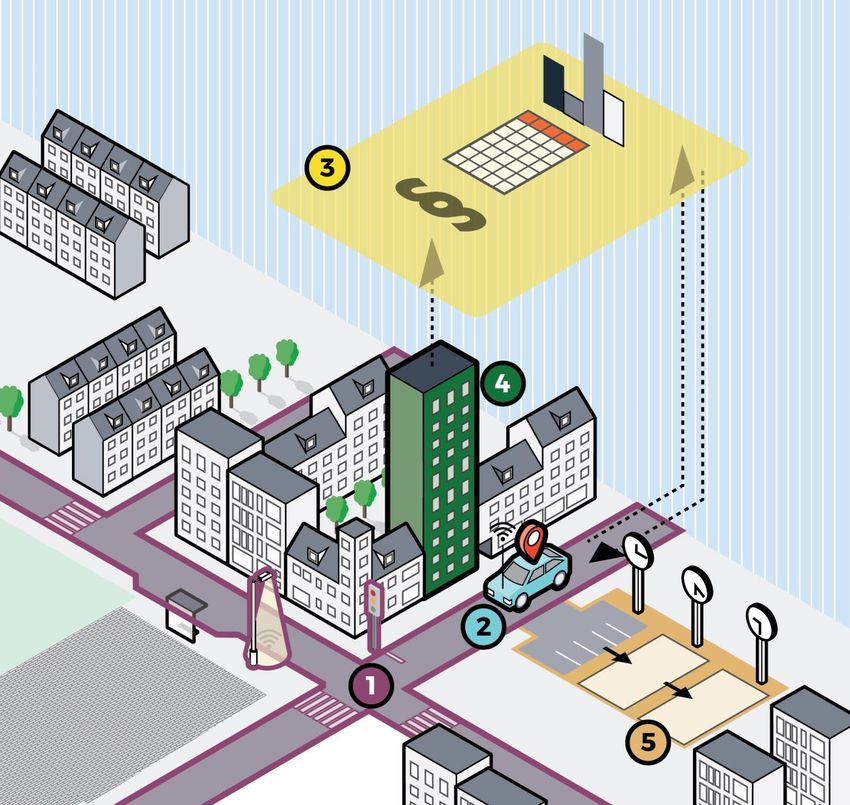
Throughout the market consultation, the system view illustrated in Figure 1 is kept in mind, which
illustrates the variety of components and perspectives that are required for a full-scale
implementation of new UVARs.
The new technology and services covered by the market consultation affect different parts of the
entire system that makes up the transport system of a city:
1. There is the infrastructure consisting of the streets, lanes, traffic signals, signs, parking,
loading/unloading, pick-up and drop-off of passengers, etc.
2. The vehicles and travellers that are moving in the infrastructure, using different modes
of transport and have different purposes of their trips
3. The digital infrastructure that can be made up by different cloud solutions, databases,
websites, and communication channels (Wi-Fi, 4G/5G, GNSS, radio communications, and
hardwired connections)
4. The city (and/or national/regional/EU-wide) administration and authorities, who decide
on regulations and are responsible for communicating and enforcing them, and are the
collectors of fees and fines
5. Spaces and areas of the city that are used not only for traffic but for other purposes.
Different UVARs affect several or all parts and especially the future UVARs that are more complex
require that stakeholders from all perspectives cooperate. Each solution must relate to the whole
ecosystem made up by these parts. Therefore, this consultation has chosen a broader perspective
than just describing new technology and its potential.
Milestone 10:
Copyright © 2019 by ReVeAL Consultation Report Page 7 of 38Figure 1: System view of the stage for future UVARs
Milestone 10:
Copyright © 2019 by ReVeAL Consultation Report Page 8 of 38Results
Description of future UVARs and related technologies
Five new or future UVARs that have been identified, and are described more in detail below:
A. Realisation of Zero/Low Emission Zones, speed limits or access restrictions through
geofencing. Geofencing is a concept which includes technical solutions combined with
suitable digital and organisational processes to make sure that vehicles follow certain
characteristics or regulations within specific geographical areas. Geofencing is considered
an important tool to create a safe road network in today’s complex traffic environment.
Geofencing is also considered to be important for future demands of safe, fossil free and
more silent transports.
B. Future pricing measures: Charging policies that regulate access to parts of the city,
streets or specific infrastructure assets. Charging policies are used today in serval cities
around the world, mainly to alleviate congestion. In the future, charging could be
differentiated based on exact usage of the infrastructure, in time, distance and location.
C. New types of ITS measures. EU defines ITS as systems in which information and
communication technologies are applied in the field of road transport, including
infrastructure, vehicles and users, and in traffic management and mobility management,
as well as for interfaces with other modes of transport. Technological developments of
connected vehicles, people, devices, and infrastructure are an import driver for new ITS
applications where data from difference sources can be shared, merged and used to
optimize and manage a variety of areas like road capacity, traffic signals, fleet
deployment for private actor, transit network, etc. Connected vehicles may open
opportunities for new mixed traffic road designs. Interesting ITS measures to ReVeAL
relate to combinations of hardware, data, and digital platforms that support real-time
control and regulation policies.
D. Dynamic kerbside or parking management. Kerbside space and parking space can be
used not only for car parking and loading/unloading, but also as sidewalk café, transit
hub, freight delivery zone, taxi stand, rain garden, or trash collection area. It could serve
many purposes throughout the day, enabled by differentiated pricing or regulation,
potentially through different types of digital solutions.
E. Access delimited to high-occupancy vehicles or differentiated charging by vehicle
occupancy. Using a combination of regulation and technology, high-occupancy vehicles
could be prioritized or rewarded before single-occupancy vehicles for access to specific
lanes and other infrastructure.
Milestone 10:
Copyright © 2019 by ReVeAL Consultation Report Page 9 of 38Technology development in four main areas enable these UVARs:
1. Vehicle automation: automation of functionality in vehicles (mainly cars, buses, trucks)
that shifts the control of certain functions from the driver to software, ultimately in a
way that cannot be overridden by the driver. With a fully automated vehicle fleet, this
would reduce or even eliminate the need for physical barriers, signing and manual
inspection of compliance. The controlled functionality could include speed limitations
(which could be set to 0 km/h on no-access lanes) or mandatory switch to electric
propulsion for hybrid vehicles. Automation also requires infrastructure digitalisation, e.g.
high-resolution, validated and updated maps for infrastructure and regulations (online or
offline), including updates on the current state of the infrastructure with regards to road
maintenance, weather, and more.
2. Positioning: high quality information on the exact location of vehicles in any given
moment, needed for e.g. automated checks on whether vehicles are inside or outside
regulated zones. Positioning work together with maps and to be useful, maps must be up
to date and validated, which is an issue that varies between regions and countries
depending on general level of citizens’ connectivity and willingness to share information,
as well as the authorities’ investments in open data and validation. Current positioning
(GNSS, 4G, short range radio communication) technology is often accurate enough to be
used for policy enforcement, where an error margin measured in meters is generally not
a problem. However, for applications where centimetres for moving vehicles are crucial,
technology is still not mature enough. When it comes to parking, positioning could be
completed by the vehicle cameras which will recognise line markings and other signage.
Total, high precision positioning is likely not to be able to solely rely on satellite
positioning (GNSS) in an urban environment, due to tunnels, dense urban networks and
urban canyoning. Cell towers are an alternative but are often not dense enough.
Therefore, cost-effective and high-definition real-time positioning in urban environments
is still a research area.
3. Connectivity: enables data transfer between vehicles, infrastructure and data sharing
platforms. Data could originate from e.g. sensors, cameras and positioning devices, UVAR
regulations that are communicated to vehicles digitally or confirmations that vehicles are
obeying these regulations. If UVAR regulation is dynamic, vehicles must be connected to
always have access to the updates set of rules. For safety applications the latency needs
to be milliseconds (or even higher), while for UVAR applications seconds may suffice
which implies a lot can be achieved already with 4G. Connectivity has the potential to
improve UVAR enforcement as vehicle identification and classification can be done much
easier. Even differentiating between through traffic and local traffic can become a lot
easier.
a. Infrastructure connectivity: This includes sensors for parking/delivery zone
occupancy, cameras for traffic flows, connected traffic lights and signs and more.
Further, a consistent data governance structure is probably necessary, since
Milestone 10:
Copyright © 2019 by ReVeAL Consultation Report Page 10 of 38connected environments (including connected and automated vehicles) will
generate large amounts of data that need to be effectively managed and
organized to extract necessary information. This structure should also include
cybersecurity infrastructure and data privacy/protection strategies.
b. Vehicle connectivity: The three categories of vehicle connectivity are: 1) Vehicle
to Vehicle (V2V) – Communication between vehicles, 2) Vehicle to Infrastructure –
Communication between vehicles and surrounding infrastructure (traffic lights,
traffic management centres etc.) and 3) Vehicle to everything (V2X) –
Communication between vehicle and technology that connects them with other
road users (e.g. cyclists, pedestrians etc.).
4. Dynamic control: Smart regulations, pricing schemes and control algorithms that could
be used to steer traffic flows and use of space in an adaptive manner, for desired
outcomes. Further, any regulation must be defined digitally in high-quality validated
maps by the city (or other) administration. With new technology and data it will become
possible to apply new control algorithms and have more complex pricing policies. At the
same time as the market for private mobility offers increases, which applies its own set
of optimisation and pricing strategies, the need for regulating these new markets will
increase. Venture capitalist funded services may overload the market with capacity at a
low price to gain market share or even to establish monopoly situations that could be
undesirable from a public policy perspective.
These technology areas are of different importance to each new UVAR.
General results from the survey
In this section, the general results from the survey are summarised. The respondents can be
divided into the following categories: regulating authorities, developers of new technology and
vehicles, research institutes and software developers, see Figure 2. The described solutions
include:
• Digitalised traffic rules and regulations and digital specifications of infrastructure
• Vehicle equipment and telematics to capture trip data and apply pricing policies
• Editor for authorities to manage geofencing zones and related policies/regulations
• Congestion charging and tolling systems for highways and tunnels
• Concept for controlling access to the city only if end-location is available
• Weight measurements of vans and trucks using inductive sensors
• Autonomous shuttles for first/last mile public transportation
• High-quality positioning
• Digital platforms for city resource and parking management (dynamic pricing, capacity,
reservation API’s)
Milestone 10:
Copyright © 2019 by ReVeAL Consultation Report Page 11 of 38• Digital platform for Infrastructure to Vehicle (I2V) communication with standardised
communication, geofence administration and management and integration with access
control systems
• Equipment and connected systems to detect and classify vehicles
• V2I communication components
• Real-time detection and reporting of vehicle emissions through remote sensing
• Detection of vehicle characteristics such as size, the temperature of the exhaust to
ensure that the vehicle is in a “warmed up” condition, number plate, speed,
acceleration, and ambient weather conditions
• Software for real-time behaviour analysis and intent prediction, for automated vehicles
Regarding the five UVARs presented previously in this report, nearly all respondents state that
they develop and supply solutions connected to enable geofencing and future pricing measures.
The least represented UVAR among the respondents is technology and solutions to benefit high
occupancy vehicles. ITS measures and kerbside or parking management are represented by an
equal number of respondents. Some respondents are not directly new technology developers, but
have still given input to this survey by commenting on for example legislation issues and how to
enable large scale tests in an urban environment.
1 - Consultation
9% 9%
2 - Govenmental
14% 3 - Hardware
4 - Research
5 - Software
14%
45% 6 - Vehicle
manufacturer
9%
Figure 2: Business areas represented in the survey results. In total 17 respondents participated.
In the following sections, findings on each future UVAR from the literature study as well as from
the survey are summarised.
Milestone 10:
Copyright © 2019 by ReVeAL Consultation Report Page 12 of 38Geofencing
Geofencing is a geographic zone that has been defined digitally, where connected vehicles1 are
controlled to follow a set of regulations, such as limited speed, access restrictions or limited use
of powertrain (typically only electric). The ReVeAL project defines geofencing as:
“A geo-fence is a virtual perimeter for a real-world geographic area. A geo-fence could be
dynamically generated – as in a radius around a point location, or a geo-fence can be a predefined
set of boundaries (such as school zones or neighbourhood boundaries).”
Out of the mentioned technology areas, geofencing requires progress in some or all of them,
depending on, for example, whether the geofencing zone is static or dynamic. A dynamic setup
means that the regulation of the geofenced zone, or the limits of the zone, changes over time
based on the current situation regarding e.g. congestion or emissions.
Geofencing is a multi-stakeholder solution that involves both public and private organisations.
Solutions offered or developed by the respondents to the survey include:
• Broadcasting of regulations through data exchange platform
• Standardisation of data formats and interfaces
• Aggregation of data
• Managing financial transactions of fees generated by access to a geofenced zone
• Platforms for creating and editing geofences digitally at a low cost, which enables
temporary local solutions when suitable (e.g. for events or roadworks)
• Other administration and management of geofences
• Positioning and localisation: GNSS (satellite), radio-based and motion sensors
• App-based solutions for end-users and for enforcement
• Installed equipment for automatic monitoring of compliance at street level
• In-vehicle equipment for automatic control of related functions
The TRL (technology readiness level)2 of the described technological solutions is generally high.
Most of the respondents’ solutions are between 7 and 9, either now or and within two years.
1 The term “vehicles” includes cars but also bicycles, scooters, mopeds, as well as trucks, buses and other
road vehicles
2 TRLs in Europe (from Wikipedia, February 2020):
TRL 1 – Basic principles observed
TRL 2 – Technology concept formulated
TRL 3 – Experimental proof of concept
TRL 4 – Technology validated in lab
TRL 5 – Technology validated in relevant environment (industrially relevant environment in the case of key
enabling technologies)
Milestone 10:
Copyright © 2019 by ReVeAL Consultation Report Page 13 of 38However, is there still a need for commercialisation among vehicle manufacturers and cities needs
to adapt the local regulations to digital standards. Authorities are still learning and exploring
needs at different stakeholders and how to establish a standardised system for data sharing. This
is done by pilot tests and voluntary regulations for special-permit transports.
Considering adjacent solutions, i.e. solutions that the respondents do not supply themselves, that
are needed for a large-scale geofencing implementation, respondents point out in-vehicle
technology (hardware and software – examples: speed control, driveline choice (diesel, electric
etc.), tyre type (studded tyres), noise rating). Even though technology maturity regarding the in-
vehicle equipment is high, manufacturers are not likely to install it unless it is requested by buyers
or made mandatory by authorities, since it constitutes an extra cost to the customer. It is
highlighted that dynamic UVARs require dynamic communication to end-users (digital signs,
websites, navigation apps and more). Further, high-quality maps and reliable connectivity are
mentioned. It is important to have standardised interfaces, so that visitors can understand
regulations in different cities. Regulations for mandatory vehicle equipment to be in place on a
given year is also suggested, and it is pointed out that a legal framework is missing, as well as
international standards for data sharing formats. Among the responses to the survey, a majority
point out public bodies as the owners to the adjacent solutions, such as national or regional
authorities, city administrations or road operators.
There are several barriers other than the technological challenges to implement geofences. When
it comes to legal matters, compliance checks and enforcement to dynamic regulations are pointed
out, and how non-authorised vehicles could be stopped from entering the zone, as well as how to
gain acceptance for dynamic regulation. EU-regulations need to be in place to be able to demand
all vehicles to be equipped at some point, or there needs to be other strategies to handle a varying
degree of equipment in vehicles. Further, the liability in case of system errors or incorrect data
needs to be addressed, as well as the challenges for cities to maintain all parts of the system
accurate.
Safety and security risks are highlighted as a main challenge. There is a risk for attacks on the
positioning technology and data. Data must be valid, unaltered from the source and trustworthy
when handling traffic flows and the systems providing the information must be secure and only
operated by authorized personnel. However, these issues apply to all UVARs and should be solved
in the design of the larger systems for positioning, connectivity etc. and not specifically for the
geofence application. Also, when entering or exiting a geofenced zone, the operation of the
vehicle must be maintained in a safe way so that sudden changes do not cause risks of accidents.
TRL 6 – Technology demonstrated in relevant environment (industrially relevant environment in the case of
key enabling technologies)
TRL 7 – System prototype demonstration in operational environment
TRL 8 – System complete and qualified
TRL 9 – Actual system proven in operational environment (competitive manufacturing in the case of key
enabling technologies; or in space)
Milestone 10:
Copyright © 2019 by ReVeAL Consultation Report Page 14 of 38However, some respondents argue that safety and security are already sound enough to allow
reliable operations, and that the main issues rather concern privacy matters.
Some respondents point out standardisation issues as one of the main challenges considering
geofencing. Standards are required to manage vehicle compatibility and for the exchange of UVAR
information a common language is needed. One respondent also highlights that cities should have
common standards and guidelines regarding factors that regulate access, for example the extent
of emissions allowed in a low-emission zone.
Regarding organisational structures and/or business models, solutions must be identified for third-
party data processing, billing, implementation in and monitoring of legacy vehicles, public-private
partnerships and the sharing of data.
The respondents’ replies on how to handle compliance (how to make sure regulations are followed,
strategies for handling non-equipped vehicles, etc.) vary due the respondents different UVAR
solutions. Technology exist that can measure vehicle emissions in real time, which can be used as
one part of the control system. When it comes to speed adaptation a general impact can be
achieved with only a limited number of vehicles being equipped with the technology. There are
also solutions to ensure performance is met not just specified, but that requires more from the
geofence system.
Trials of geofencing have been made in a few cities, see examples below.
Cologne, Germany
Ford is testing a geofencing solution for nine hybrid delivery vans operated by municipal
authorities. Cologne has a low emission zone and the geofencing system is thought to alleviate the
problems of not knowing when and where you can drive with your vehicle. With the geofencing
system, electric propulsion automatically activated when entering the zone and switched off when
leaving it. The distances travelled in different modes are stored using a blockchain solution and
can be accessed and analysed anonymously. Vehicles are connected to allow for dynamic
regulations, where the restrictions of the low emission zone can change adaptively. Ford also
carried out similar tests in London and Valencia. (Elektroniknet.de, 2019)
Ford will offer a Geofencing module for plug-in hybrid vehicles from spring 2020, for the purposes
described above (but currently without the blockchain capability), also possible to retro-fit.
(Green Car Congress, 2019)
Gothenburg, Sweden
Project ElektriCity started in 2013 and includes a range of measures to develop, demonstrate and
evaluate solutions for sustainable and attractive public transport. As part of the project, two bus
lines are geofenced to automatically follow speed limits (or even lower in areas of mixed traffic
with vulnerable travellers) and only use electric propulsion in certain areas that are extra sensitive
to noise and emissions, see Figure 3.
Milestone 10:
Copyright © 2019 by ReVeAL Consultation Report Page 15 of 38The bus lines are operated by customised vehicles, equipped with a so-called Zone Management
System, and the geofencing is static so the regulation and zone borders could be downloaded to
the vehicles once and the vehicles do not be connected.
Drivers view the system as a valuable support to focus on operating the vehicle and reduce the
risk of accidents and stress.
Figure 3: Zone Management System, ElektriCity (image from ElektriCity, 2016, legend has been translated)
Milestone 10:
Copyright © 2019 by ReVeAL Consultation Report Page 16 of 38Stockholm, Sweden
In 2018, several functions including controlled maximum speed, access restrictions and automatic
electric propulsion were demonstrated in a dense area of the city, to illustrate the opportunity
for safe coexistence of vulnerable travellers and vehicles.
In another trial where night-time distribution of goods is tested and evaluated, distribution
vehicles are geofenced to automatically switch to (quiet) electric propulsion in areas where night-
time deliveries are normally prohibited. Like the Gothenburg trials, the rules have been pre-
programmed to the control systems of the vehicles. (Ny Teknik, 2019)
The Swedish Action Plan
In 2017, the Swedish government assigned the Swedish Transport Administration to test the
concept of geofencing through demonstration projects, motivated primarily by the challenges to
reach the goals of the transport sector regarding safety, noise and pollution. One of the outcomes
of the work is a 7-step action plan to prepare for the implementation of large-scale geofencing in
cities. (CLOSER/The Swedish Transport Administration, 2018). The document describes the main
challenges and requirements to implement large-scale geofencing, as well as the anticipated
positive effects. The action plan is created in cooperation between the Swedish Transport
Administration, the cities of Stockholm and Gothenburg, OEMs Scania, Volvo Cars and AB Volvo,
and cooperation programme CLOSER.
Other examples
A few more examples of successful implementations or pilot tests where some of the respondents’
solutions have been applied include:
• Civitas Eccentric - Geofencing used to enforce electric propulsion and speed limits in
urban areas, for a plugin hybrid truck making silent night deliveries to six Mc Donald's
restaurants (Stockholms stad, 2018)
• Low emission zones in Scotland, Belgium and France where technology for remote sensing
technology was used to measure emissions (EFKON)
• Geofencing a bridge in Gothenburg – maximum speed 12 km/h, seen in Figure 3
• Dalatrafiken buses – speed limitations in a pedestrian area and in an area close to a
school (Byggteknikförlaget, 2019)
• GeoSUM project Oslo – pilot testing of max speed zones and low emission zones (SINTEF,
2018)
• WA RUC - a road usage charge pilot by the Washington State Transportation Commission.
WA RUC is designed to test multiple mileage reporting techniques and technologies, as
well as how this program might function across state lines or national borders
(Washington State Transportation Commission, 2020).
Milestone 10:
Copyright © 2019 by ReVeAL Consultation Report Page 17 of 38Future pricing measures
Pricing measures are in use in many cities, often in terms of congestion charging. Nationwide
distance-based charging is also being debated to reduce the transport sector’s carbon footprint
(and to compensate for reduced fuel tax revenues when the vehicle fleet is electrified).
From a city perspective, distance- and/or time-based charging could be a future development to
the current congestion charging schemes, where access is typically charged when entering the
zone through some type of gate. Once vehicles are connected and equipped with highly accurate
positioning devices, their individual use of the cities infrastructure could be charged and price
could be differentiated based on when the infrastructure has been used, for how long, how much
(travelled distance), between different streets or sub-zones, or even depending on the current
congestion or emission situation. Except positioning and connectivity, this UVAR also requires a
central control system (dynamic or not) that is operated by the city and where the charging
policies are communicated to vehicles and citizens, and which summarises each vehicle’s use of
the infrastructure, calculates the price and collects the fees.
There are no such setups in use yet for private vehicles, but
• in Brussels, Belgium, there is a distance-based charge in use for trucks, which uses GNSS-
tracing. An on-board unit calculates the toll to be paid, based on the number of
kilometres driven (calculated via satellite signals), which type of roads where used and
vehicle type (EFKON, 2020, Viapass, 2020). It could be expanded to a time-based
component in the future.
• In Singapore, a development from traditional congestion charging to distance-based
polling is discussed, but implementation is still a couple of years in the future.
• Regarding time-based charging, it is used in the Austrian truck polling, but it has not
been a common solution previously.
• In the USA, pilot tests are made for distance-based charging, but with the main goal to
compensate for reduced fuel tax incomes and not for controlling vehicle flows. An
example from USA is OReGO - Oregon’s road usage charge program where participants
pay for the miles they drive.
The respondents for this UVAR reasons that their solutions will contribute to the full-scale
implementation by providing:
• Data standardisation and aggregation, application of time- and distance policy and
converting it to financial transactions
• Positioning technology (and accurate time from satellite positioning). Underlying
estimation of time and distance using sensors.
• Video and/or Automatic Number Plate Recognition based charging solutions to detect and
classify all vehicles according to local schemes. Full back office enrichment and
operation of such solutions.
• Stationary, portable and mobile solutions are available to charge and/or enforce.
Milestone 10:
Copyright © 2019 by ReVeAL Consultation Report Page 18 of 38• Continuous monitoring of vehicles with respect to model and more
The three latter solutions represent equipment that needs to be installed in certain places of the
city, or moved around to monitor and detect vehicle movements and characteristics. While this is
useful, a long-term solution would include the vehicles sharing their trip data (possibly including
emissions, speeds and other useful information) in real-time and that this is converted to a
differentiated fee. Possibly such a setup would still require compliance checks using other types
of equipment installed throughout the city infrastructure.
The described solutions have a TRL mostly between 7 and 9, with a higher level for the distance-
based component.
Other solutions that are needed for a full implementation of time- and/or distance-based pricing
are solutions to guarantee privacy for the tracking and monitoring of vehicles, whereas the
technology is in place. However (as for all future UVARs), for a large-scale implementation all
vehicles must be equipped with this technology, or there must be a fair strategy to handle un-
equipped vehicles. The accuracy of maps and odometry/tachograph data (the information on
vehicle movements recorded by the vehicle using motion sensors etc.) is important as well as the
user interfaces to the pricing system.
Apart from the technology, a crucial factor is the legal framework and the public authority
solutions. These coincide with barriers for implementation mentioned in the survey:
• The development of a legal framework for this system
• Privacy/GDPR issues: which personal information can be provided or used for such a
solution and to enforce it? This also affects whether cloud-based services could be used,
since it could be prohibited to move data abroad.
• The reliable exchange of data/information in an urban environment
• The public organisation in charge must be adapted to be able to handle the solution. For
example, there could be discrepancies between the organisation benefiting from such a
solution and the one that needs to perform the investment.
• It is highlighted that common standards within the EU would be suitable. Currently each
country, city or region often have their own standard. However, other respondents claim
standardisation is not an issue in this case.
• The risk of access discrimination based on income, as lower income communities will
have less options to access these zones.
New types of ITS measures
ITS measures are not in the future, but there is a wide range of ITS solutions in use in cities all
over the world. However, it is a field of measures that is developing as technology and access to
data evolves rapidly. Advanced solutions to manage traffic effectively in cities could be the
outcome of developments in
Milestone 10:
Copyright © 2019 by ReVeAL Consultation Report Page 19 of 38• infrastructure and vehicle connectivity
• monitoring of congestion, noise and emissions
• communication to drivers regarding e.g. navigation, route choice and parking/loading
accessibility, and traffic jams or accidents
• machine learning to find smart ways to steer traffic flows in different situations
• and more.
Using these technologies, traffic control centre could obtain detailed, real-time data on the traffic
situation, provided by data streams from sensors, cameras and information shared by connected
vehicles. Accurate short-time forecasts and decision-making could be supported by advanced
algorithms, and traffic flows re-directed/optimised through dynamic signing and through the
vehicle interface and smartphones.
Solutions provided by respondents to the survey include:
• Software to control dynamic physical barriers to an area (active speed bumps, dynamic
bollards and gates)
• Privacy-proof camera detection of oncoming bicyclists to configure traffic lights in real-
time (to give priority for bicyclists)
• Tools for data processing, network map matching, network reasoning, prediction and
more to influence traffic flow by traffic signals, variable message signs, ramp metering
etc.
• Positioning estimates, which is used for interpretation and validation of data that needs
to be exchanged as part of many ITS solutions
• Solutions for standardisation, interfaces and business models
• Bus prioritisation using traffic signals
• V2I communication components
• Real-time detection of emissions from individual vehicles
• Software for footfall measurements of pedestrian and bicycle travel patterns
The ITS technology represented by the respondents has generally a high TRL, from 7 to 9 and in
use. However, that is for the software part. The access control system and the technology for the
micro-mobility users has a TRL between 2 to 4.
A few examples of successful implementations where some of the respondents’ solution has been
applied:
• Socrates 2.0 is a European project based in cooperation of road authorities, service
providers and car manufacturers. The project promotes the European wide introduction
of traffic management and navigation services in mobile/in-car devices. For this, a well-
structured cooperation between road authorities, service providers and car industries
needs to be developed, making use of newly developed business models which create a
win-win-win for both public and private stakeholders and users and new data exchange
protocols to provide technical solutions throughout the complete traffic management
Milestone 10:
Copyright © 2019 by ReVeAL Consultation Report Page 20 of 38(value) chain. And also paving the way for large-scale deployment of self-driving cars
(Socrates 2.0, 2020).
• TLEX I2V is a platform especially designed to connect roadside equipment to information
brokers, automotive industry, road authorities and road users. It is live on a national
scale in The Netherlands, processing over 250 million messages a day (Monotch, 2020).
• Traffic Solutions for Amsterdam and Copenhagen, MobiMaestro. A network management
system to combine information from different traffic systems. Together with travel-time
information and traffic counters, the cities can manage the whole city and not something
as specific as one item such as traffic or parking guidance, but the complete flow
(Technolution, 2019).
• Nordic Way 2 and 3 projects. Nordic way is an EU project to test and demonstrate the
interoperability of cellular C-ITS (cooperative ITS) services both for passenger and freight
traffic, piloting continuous services offering a similar user experience in the whole
NordicWay network in Denmark, Finland, Norway and Sweden (Nordic Way, 2020)
• Fleetwide testing that involves notifying individual motorists based in the result of
detected emission. It rewards the cleanest cars on the road in Nashville, Tennessee in
the United States (Hager Environmental & Atmospheric Technologies, 2020)
• PRoPART is an EU funded cooperation project focusing on autonomous vehicles and
advanced driver assistance systems. The main idea behind the project is to develop and
enhance an RTK (Real Time Kinematic) software solution by both exploiting the
distinguished features of Galileo signals as well as combining it with other positioning and
sensor technologies (PRoPART, 2020)
• Einride – autonomous, all-electric transport vehicles (Einride, 2020)
• Asta Zero - full-scale independent test environment for future road safety (Asta Zero,
2020)
• Delivery of footfall data for several cities such as Stockholm (Bumbee Labs, 2020)
Other solutions needed for full implementation that are mentioned are correct maps, edge
computing, reliable and predictable network connectivity, low-cost sensor technology and V2V
and V2X communication equipment and standards.
As for the other UVARs, it is highlighted that rather than technology, which works or is at high
maturity, main challenges for implementation are centred on communication, legal framework,
enforcement, public authority solution and policy.
More in detail, identified barriers include the public sector being slow to implement new
technology, sharing of data or access to software between stakeholders, insurance and liability
complexity, and different communication standards.
Regarding safety and security, it is viewed as a challenge in terms of guaranteeing valid and
trustworthy data and prevent unauthorised access to the system settings. It is not clear who will
be responsible for cybersecurity oversight and be liable for the decisions. However, as mentioned
earlier, these matters are not unique for this UVAR, but need to be addressed generally as the
transport system becomes more connected and more data is transmitted between actors.
Milestone 10:
Copyright © 2019 by ReVeAL Consultation Report Page 21 of 38Other challenges concern organisational matters. Who should own and maintain the infrastructure,
how will operators and purchasing organisations handle payments, forms for public-private
partnerships, business models for data sharing are different examples that are highlighted.
As for other UVARs, standards are required to allow different vehicles to operate in different
cities. The ideal case would be a global standard. However, some respondents claim standards are
already in place.
A specific challenge in this field is sensing micro-mobility and pedestrians, as the ITS domain
traditionally is very car/truck focussed. Also reaching these travellers must be done differently
as bicyclists rarely use navigation apps.
Dynamic kerbside or parking management
Vehicles entering a city often (but not always) are heading one or several specific destinations,
either to park, load or unload goods or pick up/drop off passengers. By controlling the how and
when these destinations could be accessed by vehicles is therefore a way to regulate access. This
UVAR includes all measures where the use of kerbside and parking space in managed in new ways
with the consequence that the space is utilised for different purposes over time. However, these
types of measures are mainly motivated by increasing market shares in for-hire vehicle services
and e-commerce that lead to dramatic increase in use of the kerbside for loading/unloading of
passengers and parcels. This comes with new congestion challenges and traffic safety issues.
Continuous enforcement of kerbside regulations is hard, since a drop-off or pick-up only takes
seconds. New types of UVAR that regulate and enforce the use of kerbside capacity in real-time
are needed in a short to medium term. On the kerb itself, and/or between motorized vehicles and
pedestrians, there are potentially rapidly changing conditions related to bicycle use, electric
scooters, automated delivery drones that may require new types of regulation and their own
dedicated space in the urban landscape.
For dynamic kerbside/parking management to work, there are (as for all UVARs) several
components that should be in place. The use of the chosen space should be monitored, for example
by using sensors or cameras or by the automatic reporting by the vehicles themselves. The
regulation of use should be formalised and communicated, in terms of access regulations, pricing,
dynamic signing and other information streams e.g. through a smartphone app or other digital
channels. Finally, the regulation itself could be dynamic, to find a smart way to use the space for
regulating traffic and create an attractive street environment, but still meeting the needs for
accessibility, mobility and freight.
The respondents to the survey present solutions or tests including:
• Data standardisation and aggregation, application of off street parking policy and
conversion to financial transactions
• Positioning and localisation technology for parking space and vehicles
Milestone 10:
Copyright © 2019 by ReVeAL Consultation Report Page 22 of 38• Platform for space reservation APIs, dynamic pricing and capacity management
• Solutions including sensors and better data to improve usage and availability on loading
zones
TRLs vary between sub-solutions. Parking management, occupancy monitoring and positioning are
at TRL 7-8 or proven technologies. However, it is considered a challenge to achieve large-scale,
cost-effective and reliable sensing with high definition in urban public space, which lowers the
maturity of the measure.
The respondents’ solutions have been successfully implemented in:
• TLEX Parking Platform (TPP), is a technology that helps get rid of streets full of cars,
while the parking garages are insufficiently used, making better use of the parking
garages and reduce search time for parking spaces. Parking-providers connect the off-
street parking facilities to the TPP. Once the connected service-providers can resell their
parking places the service providers can offer reservations and booking to their
consumers in their apps or websites (Monotch, 2020).
• Pilot projects in Washington D.C that address challenges for a variety of kerb
stakeholders including, but not limited to, residents, business districts, freight vendors,
nightlife patrons, and for-hire vehicles. Tools deployed to-date include real-time parking
sensors, demand-based pricing, commercial loading zone fees, and time-of-day-based
parking restrictions (District Department of Transportation, 2020).
• The city of Stockholm is launching a demonstration within the NordicWay project to test
better loading zone usage in 2021 (NordicWay).
• Volvo M – smart car sharing in Stockholm. Ongoing test in Stockholm. Free up parking
space for the city to use for something else.
There is a need for the next generation positioning (GNSS) accuracy and high-accuracy kerb-level
maps to scale up this type of measure. Further, cheaper sensors with less impact in the
attractiveness of public space are needed as well as solutions to protect the privacy of individuals.
Other barriers that are mentioned in the survey are for example:
• City plans that stipulate usage might delay the development
• Once again is the need for standards mentioned as a main challenge
Rewarding high-occupancy vehicles
Already today in some places, vehicles with many passengers are allowed do use bus lanes
(diamond lanes in North America/car-pooling lanes), to steer against higher utilisation rates of
vehicles (and thereby less vehicles). This measure could be expanded to differentiate e.g.
access to low-emission zones or pricing to access urban areas. It would require automatic
sensing of the number of passengers in a vehicle, and that this information could be shared with
the platform that calculates fees or enforces access restrictions. There are obvious privacy
Milestone 10:
Copyright © 2019 by ReVeAL Consultation Report Page 23 of 38issues with forcing travellers to share this type of information and checking compliance by e.g.
cameras. But as an alternative, drivers could share this information voluntarily and gain access
to regulated lanes or lower fees in return. Of course, information of number of passengers must
be validated by trusted in-vehicle technology.
Respondents in the survey develop or supply solutions for this measure by:
• data standardisation
• connection to Bluetooth-based occupancy measures
• application of high-occupancy vehicle policy or discount, and calculation on fees based
on that
Devices and solutions to estimate the number of people within a vehicle is considered a research
area by some, but not all respondents.
The TRL for these development areas are between 2 and 7, which makes the solution more long-
term than the other UVARs discussed in this consultation.
Some of the successful implementations are:
• In Austria, the toll sticker system has established itself as the tolling method for vehicles
with a maximum permissible gross weight under 3.5t. EFKON has supplied mobile systems
for the automatic control of toll stickers. The system helps to automatically identify toll
violators without interrupting the flow of traffic, thus increasing traffic safety (EFKON,
2020).
To be able to get full implementation of the UVAR, the respondents need improved AI/ML for
Bluetooth device-based occupancy recognition or improved OEM data sharing of occupancy data,
reliable sensors and communications channels to end-users.
The respondents point out barriers considering absence of standard rules and regulations
applicable for autonomous vehicle systems and there is a lack of safety directive harmonisation
across the industry and government agencies. Possible manipulation of occupancy sensor data
must be addressed. Further, as for all addressed UVARs, the need for standards in general is
highlighted as a barrier for large-scale implementation.
Legal framework
Nearly all market stakeholders raise the need to address the legal framework around new
technological solutions as one of the major issues. Access regulations (all, not just new solutions)
risk conflicting with a few principles of the European transport system. Firstly, infrastructure that
already exists and have been financed using taxes, i.e. the collective of citizens, should be
available for all. Secondly, the principle of freedom of movement, which says all EU citizens can
transport themselves throughout the union, without discrimination because of citizenship imposes
challenges towards adapting new technology that may not be available in the all EU countries. If
Milestone 10:
Copyright © 2019 by ReVeAL Consultation Report Page 24 of 38You can also read