Extraordinary Council Meeting - Separately Circulated Attachment 8 July 2021 - This attachment relates to Item 4 - Marlborough District Council
←
→
Page content transcription
If your browser does not render page correctly, please read the page content below
Extraordinary Council Meeting
                       8 July 2021

 Separately Circulated Attachment
      (as indicated this is circulated separately to the Agenda)

    This attachment relates to Item 4
             in your Agenda

              Attachment 4.1 –
Statement of Proposal July 2021 (Draft Bylaw)
+

    Page 0
Contents
1.    Introduction............................................................................................................................................................2
2     Reasons for the proposal ......................................................................................................................................3
3.    Options/Alternatives ..............................................................................................................................................8
4.    Preparation of a draft Bylaw ................................................................................................................................13
5.    Draft Bylaw ..........................................................................................................................................................18
6.    Where to get more information ............................................................................................................................39
7.    Have your say – Council wants your feedback ...................................................................................................39
8.    What happens next? ...........................................................................................................................................39
9.    Timeline ..............................................................................................................................................................39

                                                                         Page 1
1. Introduction
Council is proposing to regulate the use of motor                    The 2016 Kaikōura earthquake has provided an
vehicles on the beach and unformed legal road to                     opportunity for the community to assess the impact of
                                                                     continued vehicle use on Marlborough’s east coast
and along part of Marlborough’s east coast, between
                                                                     beaches. We all share a common responsibility to
the Awatere River and southern district boundary.                    balance human activities in the natural environment to
This Statement of Proposal has been prepared as                      ensure future generations can still enjoy the coast long
part of consultation regarding the making of a Bylaw                 into the future.
under the Land Transport Act 1998 (LTA) and the
                                                                     In order to maintain public access for multiple users
Local Government Act 2002 (LGA).                                     without impacting on public safety or ecosystems is the
                                                                     challenge facing Council and the community to find a
The magnitude 7.8 earthquake that struck the north-
east coast of the South Island of New Zealand in                     workable solution that addresses the diverse values and
                                                                     preferences of users in a compatible way.
November 2016 caused extensive upheaval, between
1-6 metres, over 110 km of coastline. In Marlborough,                This Statement of Proposal includes:
areas around Cape Campbell experienced 1-2m of
uplift. Degradation of an environment is usually                     •      The reasons for the proposal;
considered to occur incrementally over time as
stressors accumulate. In this instance, however,                     •      The options and alternatives considered by
major disruption occurred within a period of a few                          Council;
minutes. It is known from other large earthquakes that
the effects of uplift can be devastating and take years              •      The analysis used in preparing the draft Bylaw;
to recover.
                                                                     •      A draft Bylaw; and
In addition to the devastation of parts of the coastal
environment, there were large social, economic and                   •      How people can present their views to Council
cultural impacts.     The new land uplifted in the                          on the proposal.
earthquake has new values and with these come new
uses, stressors and threats. People continue to have
multiple interactions with the new configuration of the
coastline, which will ultimately influence the rate and
                                                                           The characteristic
degree of recovery of key habitats and the assemblages
that formerly occupied them.
                                                                           values of the east
Prior to the 2016 Kaikōura earthquake, high tide
                                                                         coast are documented
prevented people from walking or driving along the foot                  in a Technical Report
of the bluffs from Mussel Point to Cape Campbell.
Rocky headlands and high tides prevented all motor                       produced by Council.
vehicles (vehicle) other than ATV’s from using the beach
between Mussel Point and Long Point (about 11km
south of Cape Campbell). Access was not possible for
any vehicle between Long Point and Chancet Rock. At
Cape Campbell vehicle access is on formed private
roads through farmland with the owner’s permission.
Following the earthquake, the high tide mark has shifted
down the beach. Where people were only able to travel
through in a vehicle up to two hours either side of high
tide, they can now travel through at any time.

Two issues have been identified by Council regarding
the continued, uncontrolled vehicle use on the east
coast: Firstly, the effect on public safety and enjoyment
of the area and secondly the adverse effects to the
values on the east coast environment. This is the
perceived problem. For the purposes of this Statement
of Proposal the terms “motor vehicle” and “vehicle” both
mean a motor vehicle as defined in s2(1) LTA.

University of Canterbury undertook an online survey of
public perceptions for the earthquake affected beaches
in December 2020. The survey findings identified a
wide divergence of views on positive and negative
aspects some of which were contradictory.

                                                            Page 2
2        Reasons for the proposal
Background                                                       Councillors requested staff prepare a report
                                                                 identifying the key threats and a range of potential
Following the magnitude 7.8 Kaikōura earthquake in               solutions that would help to provide protection along
November 2016, Marlborough’s east coast became                   the coast in balance with potentially retaining existing
much more accessible, as the seabed lifted and wide              recreational and commercial uses.
new expanses of beach and exposed reefs were
created.                                                         Investigation
Soon after the earthquake, members of the                        Council staff commenced investigating legal
community expressed a range of concerns to Council               mechanisms to protect the east coast ecosystems
mainly centred on the potential impacts of public                and providing for public safety. An initial assessment
vehicle access to the habitats of the coastal                    considered stopping the road, using the mechanisms
environment and the risks that poses to flora and                under the RMA to add zone rules to the Proposed
fauna and those coastal ecosystems. Concerns                     Marlborough Environment Plan (PMEP) or the use of
focused on vehicle use compromising the structure                a Bylaw. Staff also reviewed which mechanisms
and composition of dune systems and disruption to                other Councils were using to restrict vehicle use on
flora and fauna. Another concern raised by the                   beaches. Depending on the type of Council, regional
community related to public safety to beach users                or territorial, and their location to the coast, both of
sharing the beach with quad bikes, motorcycles and               the former mechanisms are being used throughout
4WD vehicles. The East Coast Protection Group was                New Zealand. At the time this assessment was being
formed with multi stakeholder representation to try              done, Council had notified the PMEP in June 2016
and bring together the collective interests of the               (prior to the earthquake) and a review of speed limits
community, iwi, recreational and commercial sector               in Marlborough was about to commence by
groups.                                                          Marlborough       Roads,      Marlborough’s     Roading
                                                                 Authority. Council staff prepared an issues and
The Royal Forest and Bird Society NZ Inc. presented              options paper that included the legal and statutory
an item to the Environment Committee of Council on               requirements required to be taken into account and
15 March 2018 expressing its concerns about                      the corresponding mechanism that could be used.
environmental impacts of human activities in the                 These are the same options included in Section 3 of
coastal environment and sought policy solutions to               this proposal.
address the environmental effects from the
earthquake.                                                      Technical Advice Workshop
Council agreed to investigate the impacts of the                 At the same time Council was investigating the legal
earthquake and to undertake a policy assessment in               mechanisms, Council and DOC convened a
respect of the jurisdiction and responsibilities with iwi,       Technical Advice Workshop on 23 July 2018 to
and other agencies that have responsibility for the              establish the values of the east coast area to:
east coast environment. There is Department of
Conservation (DOC) administered land along the                   •    Identify the     values   of   the    east   coast
coastline.   The Clifford and Cloudy Bay Marine                       environment.
Mammal Sanctuary is also administered by DOC                     •    Determine the threats from human activities.
under the Marine Mammals Protection Act 1978.
                                                                 •    Identify potential    measures      to  reduce
It was acknowledged the issues raised were complex                    environmental impacts where identified.
and that any options for policy intervention would
require consideration of the views of iwi, stakeholders          The focus area was defined as the coastline margin
and the community.                                               from the Awatere River to the Waima (Ure) River.
An initial assessment of the recreational values along           A range of technical experts presented at the
the coast by Council confirmed the following:                    workshop to provide advice on the biodiversity and
                                                                 ecological values as well as the historical and
•    People access the environment for a range of                recreational context. A list of presenters is provided
     reasons    including     social,   cultural, and            in Appendix 12 of the Technical Report (v5,4 Julyne
     recreational and food gathering purposes.                   2021).
     Commercial and recreational fishing, camping,
     walking, horse riding are some activities that              It was reported at the workshop that the intertidal
     occur. Vehicles are used both recreationally                habitats were greatly affected with extensive die off of
     and for access to fishing and diving spots.                 algae communities, high mortalities of benthic
                                                                 invertebrates and greatly reduced ecosystem
•    The importance that the community places on                 functioning. The combination of habitat disruption,
     specific values is wide-ranging and variable.               loss of species and their functioning requires multiple
•    The main community tension that exists is a                 perspectives on recovery dynamics.
     consequence of human behaviour and the                      The dunes were uplifted and moved further from the
     means by which people travel along the coastal              influence of the sea. New dunes are gradually
     environment to their place of interest.                     forming as vegetation re-establishes on the uplifted
                                                                 beaches. Log debris is gradually accumulating in a

                                                        Page 3
new zone seaward of the pre-earthquake log debris                     Vehicle impacts on Marlborough’s east coast can be
zone along the interface between grass and gravel.                    broken down into five broad topics:
These zones provide an important home for lizards
                                                                      1.   Soft sediment community damage.
and there is a need to monitor the transition between
old and new areas. New logs have to accumulate in                     2.   Reef community damage.
order to provide this habitat in the future, and plant re-
establishment plays a role in covering and stabilising                3.   Dune vegetation damage.
them.
                                                                      4.   Bird and pinniped disturbance.
There were also impacts to the habitats of the
vegetation and fauna species along the coast. The                     5.   Natural character.
ongoing management of indigenous beach vegetation
requires attention to beach disturbance and control of                1.    Soft sediment community damage – Shellfish
invasive marram to allow native sand species to
                                                                      Vehicle disturbance is occurring in the new
establish and recover. This will allow natural beach
                                                                      accumulation zones. Juvenile shellfish are being
communities to prevail, providing habitat for banded
                                                                      damaged by vehicles crossing the intertidal zone
dotterels, skinks and other beach fauna.
                                                                      (below the high tide mark) which is also threatening
There has been an observed increase in the number                     recruitment.
of visitors to the area after the earthquake. As well as
                                                                      Damage is occurring on the fine sandy beaches at
increased numbers of vehicles it was noted that other
                                                                      Marfells Beach and between Mussel Point and Cape
interactions of humans on the coast are also causing
                                                                      Campbell.
an impact.
                                                                      An assessment of vehicle impact on the biota of
At the workshop it was confirmed that vehicles are:
                                                                      sandy beaches and coastal dune is provided in the
•    Driving at speed.                                                following report by DOC from 1999:

•    Driving further along the coastal margin                         https://www.doc.govt.nz/Documents/science-and-
     compared to before the earthquake in 2016.                       technical/sfc121.pdf

•    Driving over multiple ecological environments                    In terms of shellfish this has been built on by later
     with tracks all over the beach and above it.                     studies, mainly on Toheroa in northland by Phil Ross
                                                                      and research group in Auckland:
•    Driving on what was the old storm beach, now
     high and dry, preventing colonisation by plants                  https://www.researchgate.net/publication/320303922_
     and the creation of new habitats.                                The_biology_ecology_and_history_of_toheroa_Paphi
                                                                      es_ventricosa_a_review_of_scientific_local_and_cust
•    Crushing raoulia (vegetable sheep), pimelea                      omary_knowledge
     mats and other special plants which grow on a
     gravel pavement at Needles Point.                                This MPI report gives a good summary of Toheroa
                                                                      knowledge at that time about vehicle impacts which
•    Disturbing banded dotterel and variable oyster                   has some relevance to the email below:
     catcher nesting habitat.
                                                                      https://www.researchgate.net/publication/269394999_
•    Disturbing lizard and invertebrate habitat.                      Review_of_factors_affecting_the_abundance_of_tohe
                                                                      roa_Paphies_ventricosa#pf16
•    Likely to injure or kill birds, lizards and
     invertebrates.                                                   “Moller et al. (2009) conducted an experimental study
                                                                      to investigate the impact of vehicle traffic on toheroa.
•    Providing tracks for predators, especially those                 Preliminary tests on ten buried adult toheroa found
     left after driving through vegetation.                           that none were damaged by vehicle passes, and
Following the workshop, Council compiled the                          therefore, the study focused on juvenile toheroa (5–
information into a Technical Report. The first version                30 mm). Three hundred and three juvenile toheroa
of this report was released on 23 March 2019. A                       found drifting in the surf zone were allowed to bury
subsequent version was released in December 2019,                     themselves either just below the high tide mark or in
incorporating additional information to fill gaps that                the mid/lower beach. The toheroa were then driven
were highlighted in the previous versions. Map 1                      over one or five times with a motorbike (Honda CRD
below shows the characteristic values of the East                     250R), car (Toyota Fielder), or utility vehicle (Mazda
Coast identified in the Technical Report (v54, Julyne                 BT50 Freestyle cab and Isuzu Bighorn). Toheroa
2021), compared to where vehicles travelled before                    mortality was found to vary with location on the beach
and after the earthquake.                                             and type of vehicle. For all vehicles excluding
                                                                      motorbikes, the average mortality incurred was higher
Impacts of vehicles on the environment                                on the upper beach (14%) compared to the mid/lower
                                                                      beach (3%); for motorbikes, the average mortality
After the Technical Advice Workshop, Council staff
                                                                      incurred was high (18%) compared with that from the
undertook a literature review of research of vehicle
                                                                      other vehicles (3%, average mortality across all other
impacts on beaches. The citations for the documents
                                                                      vehicles). Driving the test vehicle five times over the
referred to in this section are in the bibliography of the            toheroa appeared to cause higher mortality than a
Technical Report (v54, Julyne 2021).
                                                                      single pass, but the difference was not statistically
                                                                      significant.”

                                                             Page 4
Ecosystems Consultants prepared a report for Te Ao                  feeding sites exist below the Mean High Water
Mārama, Environment Southland, Invercargill City                    Springs (MHWS). Birds feed on sand hoppers or
Council and Department of Conservation on the                       shellfish in beach cast seaweed or in the recently wet
Impact of vehicles on recruitment of toheroa on Oreti               sand and reef.
Beach, Southland, New Zealand:
                                                                    Driving on the beach can cause disturbance of
http://www.ecosystemsconsultants.co.nz/files/ecosyst                wildlife. Examples include driving through bird
ems-consultants-report-2014-02.pdf                                  roosting and nesting areas or disturbing breeding
                                                                    seals.
The referenced thesis by Taylor explored the impacts
of vehicles on tuatua – mortality was found to be                   Bird Disturbance from human activity – Potential
about 5%:                                                           effects from recreational activities on sea and shore
                                                                    birds – Avon-Heathcote Estuary Ihulai Trust. Bonnie
https://ir.canterbury.ac.nz/bitstream/handle/10092/820              Kaldor. September 2029
7/thesis_fulltext.pdf?sequence=1&isAllowed=y
                                                                    Florida game and wildlife website bird disturbance
Nelson City Council commissioned Cawthron Institute                 education:
to assess the ecological impact of vehicle traffic
vehicles driving across the tidal flats at low and mid              https://myfwc.com/viewing/how/bird-disturbance/
tide levels at Delaware Inlet an estuary of the
Wakapuaka River north of Nelson:                                    5.   Natural character.

http://www.nelson.govt.nz/assets/Environment/Downl                  Vehicle noise and tracks are impacting on the
oads/Nelson-Plan/Nelson-Plan-Coastal-Final-                         naturalness, ambience and aesthetics of the area.
CawRpt-3015-Impacts-of-vehicle-traffic-Delaware-                    The area is identified as an Outstanding Natural
Inlet-Cawthron-Institute-June2017.pdf                               Landscape (ONL). An assessment of the impact of
2.   Reef community damage - Shellfish and algae                    vehicles tracks to the ONL is provided in section 3.3.1
                                                                    in the Technical Report (v54, Julyne 2021).
There is evidence of vehicles driving on reef systems
damaging the reef structure and limiting the                        Confirmation of the perceived problem
recolonisation of marine plants and algae.
                                                                    At a meeting of the Planning, Finance & Community
“The reefs of this area were uplifted during the quake              Committee (PFCC) on 28 November 2019 Council
(as were the beaches). As species attempt to                        reviewed the Technical Report material (v3 December
recolonise these reefs in the intertidal zone any                   2019) and issue and options report presented to
vehicle impacts will be disastrous to recently settled              them.
and newly colonising species,” University of
                                                                    Council confirmed the concerns raised by the
Canterbury.
                                                                    community about the increased use and types of
Councils around New Zealand have banned driving                     recreational vehicles using the east coast after the
on intertidal reefs because of the negative impacts.                2016 Kaikōura earthquake. There are two issues:
Given the recovering nature of the ecosystems in this
                                                                    1.   Uncontrolled vehicle access to Marlborough’s
area the impacts are only going to be exacerbated.
                                                                         east coast is causing a danger to public safety
3.   Dune and vegetation                                                 and public enjoyment of the coast.
Vehicles are driving on the original dune systems at                2.   Uncontrolled     vehicle      access       along
Mussel Point, Waima (Ure) River mouth, south of                          Marlborough’s east coast is damaging the
Needles Point, Lake Grassmere/Kapara Te Hau                              environment, ecosystems and impacting the
dunes damaging threatened vegetation and fauna                           natural processes of recovery following the 2016
communities and archaeological sites.                                    Kaikōura earthquake.
Vehicles are now driving on the newly established                   This is the perceived problem. Council felt compelled
dune systems from the Awatere River mouth to                        by the evidence presented that the earthquake has
Waima (Ure) mouth and further to Wharanui,                          given the community an opportunity to assess the
preventing   the  establishment   of  indigenous                    continued use and access to the east coast that
communities.                                                        preserves its uniqueness for future generations.
The impacts of vehicles on dunes are documented in                  Council instructed staff to prepare a draft Bylaw as
these publications:                                                 the preferred method to address the problem, to
                                                                    engage with iwi and undertake consultation with
https://www.coastalrestorationtrust.org.nz/site/assets/f            stakeholders including NZ Police, NZTA, DOC,
iles/1185/10.2_effects_of_vehicles.pdf                              Ministry for Primary Industries, adjoining landowners
https://www.doc.govt.nz/Documents/science-and-                      and commercial paua and crayfishrock lobster
technical/sfc121.pdf                                                industries representatives.

4.   Birds and pinniped disturbance.
There is evidence of damage of habitat by vehicle
traffic, particularly the breeding sites of ground
nesting birds such as banded dotterels and
oystercatchers which nest on the open beaches. Bird

                                                           Page 5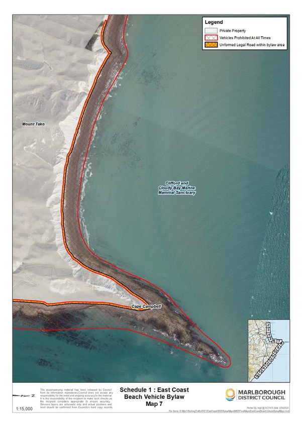
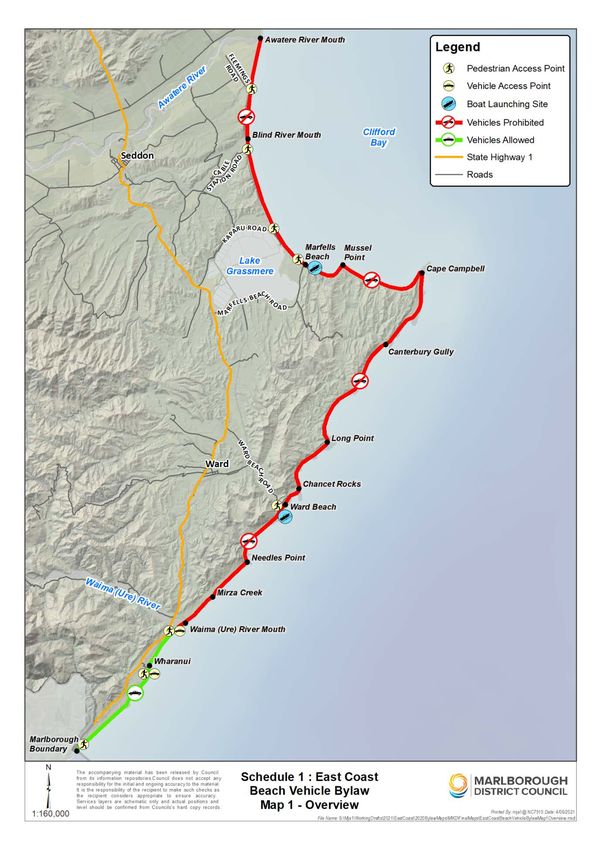
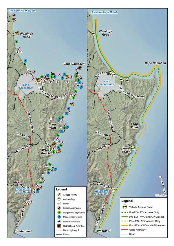
Map 1: Location of values compared with
                 vehicle use on the east coast
Note: These are the indicative locations from the maps in the Appendices of the Technical Report (v54, Julyne
2021).

                                                      Page 6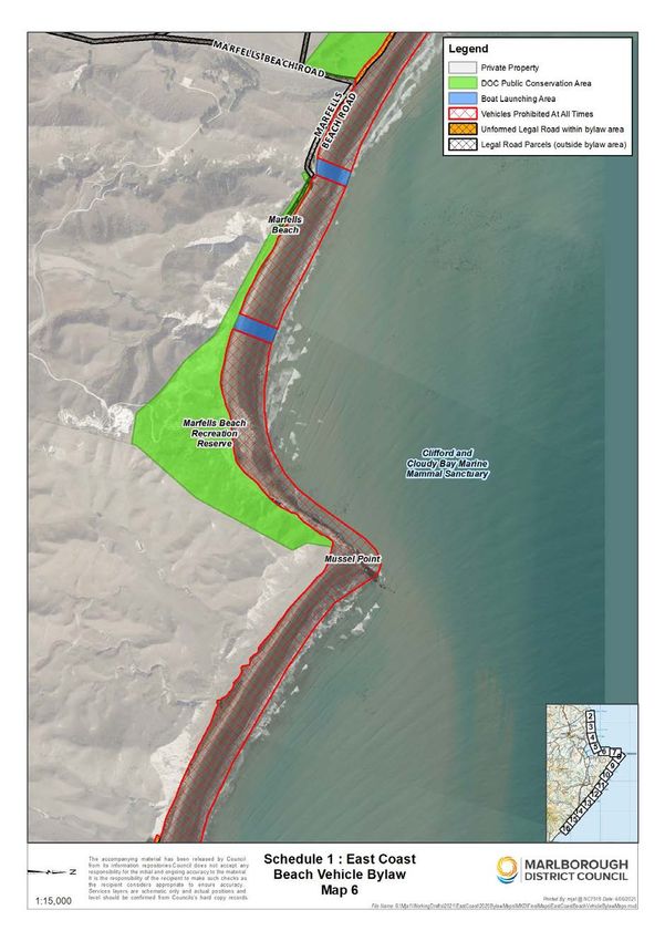
Consultation and feedback                                          The media coverage following the November 2019
                                                                   meeting generated public interest in the preparation
Following the November 2019 PFCC meeting,                          of a draft Bylaw. As a result Councillors agreed at a
discussions commenced with affected stakeholders                   PFCC meeting on 19 March 2020 to accept feedback
during the preparation of a draft Bylaw to manage                  from interested parties.
vehicles on Marlborough’s east coast. The Technical
Report (v3 December 2019), Issues and Options                      The comments received from interested parties both
Paper and the agenda item from the PFCC on 28                      supported and opposed Councils proposal to restrict
November 2019 were used as a basis for discussion.                 vehicles through a Bylaw.    The comments that
                                                                   disagreed with Councils approach had a common
Letters were emailed to statutory bodies and                       theme:
representatives of the commercial paua and
lobstercrayfish industries. Letters were also sent to              •   Educate by erecting signs instead of banning
landowners adjoining the focus area with an offer to                   vehicles.
meet as required in the 2020 New Year.
                                                                   •   Vehicles with soft tyres (ATV, quad bikes) have
Ngāti Kurī are the tangata whenua who have                             minimal impact and driving below the MHWS has
manawhenua and manamoana in the area covered                           no environmental impact.
by the draft East Coast Beach Vehicle Bylaw.
                                                                   The proposals received from members of the public
Manawhenua and manamoana are determined by
                                                                   asked for an alternative approach to be considered
whakapapa, and confer customary authority. The
                                                                   before a draft Bylaw was notified. This alternative is
manawhenua and manamoana status of Ngāti Kuri
                                                                   included in Section 4 of this Statement of Proposal.
comes from continuous land use and occupation. Te
Rūnanga o Kaikōura is the modern assemblage and                    Further engagement was required with iwi before a
representative of the hapū, Ngāti Kurī, one of the 18              draft Bylaw could be presented to Council.
Papatipu Rūnanga of Ngāitahu who are statutorily
acknowledged under the Te Rūnanga o Ngāi Tahu                      By the end of 2020 (the fourth anniversary of the
act 1996.                                                          earthquake) while progress was being made, Council
                                                                   was still not in a position to achieve notification of a
Te Rūnanga a Rangitāne o Wairau, Te Rūnanga o                      proposal before December 2020.           With another
Toa Rangatira and Te Rūnanga o Ngāti Rārua have                    summer season looming and with that a likely
interests in the area.                                             increase in vehicle use along the east coast, at a
                                                                   Council meeting on 10 December 2020 Council
The Mayor invited iwi to discuss whether they had
                                                                   established      a   sub-committee      to     advance
any concerns or issues about the east coast
environment.                                                       commencement of the special consultative process of
                                                                   the LGA before Council reconvened in 2021. This
Council has been engaging with iwi to understand                   was not achieved.         Instead work continued on
their concerns or issues about the east coast                      preparing the notification material and engaging with
environment.                                                       iwi.

Te Rūnanga o Kaikōura are supportive of an                         A proposal, including a draft Bylaw is now ready for
approach to prepare a draft Bylaw to prevent vehicle               public consultation using the Special Consultative
access to allow the coast to rest and recover following            Procedure of the LGA. An updated version (v54,
the earthquake. They are also keen to see protection               Julyne 2021) of the Technical Report is also being
and enhancement of the indigenous vegetation and                   released with notification of this Statement of
fauna along the coast including their sites of                     Proposal.
significance identified in Appendix 1 of the Technical
Report (v5,4 Julyne 2021).

Te Rūnanga a Rangitāne o Wairau advised Council                        Council confirmed that there
that they disagreed with the approach of a full ban of
vehicles to the east coast. The reasons given were:                         are two issues to be
•    Limiting access to all vehicles except for those                     addressed. Firstly, the
     with low ground pressure (quad bikes).                             effect on public safety and
•    To protect archaeology, dune flora and birdlife,                   enjoyment of the area and
     access should be limited below the high tide line
     (MWHS) along the foreshore.                                           secondly the adverse
•    There are issues with access to a customary                       effects to the values present
     fishery at Te Karaka.
                                                                        on the east coast identified
No formal invited participation was made with the
public or interested parties. Councillors felt they                      in the Technical Report.
understood the concerns of the community enough to
be able to notify a proposal using the special
consultative process in the LGA.

                                                          Page 7
3. Options/Alternatives
Having confirmed the perceived problem in Option 1: Do nothing, leaving
November 2019, Council also considered the unrestricted vehicle access.
options and alternative methods that could be
used to achieve the following outcomes: Doing nothing would let the status quo prevail.
Vehicle users would have no restrictions on access to
• Continued use of this significant natural and along the coast. There are currently no speed
landscape today, in a way that restores and restrictions in place for vehicles or restrictions on
protects it for future generations. where they can travel. Vehicle tracks are evidence
that users are travelling on different routes including
• Access is retained for the public in some form. habitats of indigenous vegetation and fauna as well
• Access is retained for authorised agencies such as on dunes. Instead of implementing new regulatory
as emergency and enforcement agencies and method(s), agencies could place more emphasis on
for Dominion Salt Ltd to be able to lawfully carry enforcement of existing legislation to act on offences
out its activity. under the Wildlife Act 1953.
• Provision for continued boat launching at Advantages
Marfells Beach and Ward Beach.
The interest of vehicle users, including long standing
• Provide protection of sites of significance, users is preserved.
threatened indigenous vegetation and fauna
species along the coast in balance with More of the east coast is accessible by users.
recreational and commercial uses. Public access is enhanced/promoted.
• The natural processes of recovery from the
Public can continue to enjoy the entire coast.
effects of the Kaikōura earthquake can occur
unobstructed by human activities. Users can access new fishing and shellfish gathering
• Public safety is ensured. opportunities that were previously restricted by tides.
• Noise nuisance is managed. There is more beach to drive on.
• Ensure enforcement is practical and achievable. Commercial activities are not impacted.
Under the LGA, Council is required to consider Access remains the same for emergency and
whether a Bylaw is the most appropriate way of enforcement agencies.
addressing the perceived problem. Council has Successful prosecution of an offence under existing
considered the following options/alternatives. legislation might change the behaviour of coast users.
These were presented to the PFCC meeting in an
issues and options report in November 2019: Disadvantages
1. Do nothing; leaving unrestricted vehicle Does not recognise and provide for preservation of
access. the natural character of the coastal environment or
the protection of areas of significant indigenous
2. Use voluntary methods and actions to vegetation and significant habitats of indigenous
influence and change behaviour. fauna under section 6 of the Resource Management
3. Use physical methods to stop access to all or Act 1991 (RMA).
parts of the east coast some or all of the time. This option is inconsistent with the NZCPS and PMEP
4. Stopping the unformed legal road under as it allows vehicle access in areas that have the
section 342 and Schedule 10 of the Local values that Policy 20 (see below) provides should be
Government Act 1974. protected.
5. Add zone rules to the Proposed Marlborough Continued use of vehicles may damage sites of
Environment Plan to give effect to existing significance to tangata whenua [sections 6e and 8
policies under the Resource Management Act RMA].
1991 and the New Zealand Coastal Policy
Statement 2010. Dunes or other ecological systems or processes on
the coast are still at risk from damage.
6. Make a Bylaw under the Land Transport Act
1998 (LTA) and the Local Government Act Vehicles can access parts of the coast that were
2002 (LGA). previously inaccessible (e.g. south of Long Point).
An analysis of these options including the advantages More vehicles, more of the time, mean more stressors
and disadvantages for each option follows. to the values identified in the Technical Report (v54,
Julyne 2021).
Page 8Vehicles are likely to harm indigenous vegetation and Signs can reinforce regulatory methods such as a
fauna, particularly in the new accessible parts of the Bylaw.
coast between Mussel Point and Chancet Rock.
Disadvantages
Vehicles disturb the peaceful enjoyment of the coast
by other users. Status quo prevails unless new signs and educational
material are prepared that encourages behaviour that
Public safety will be compromised by sharing the protects archaeological sites, indigenous vegetation
coast with more and larger vehicles. and fauna. The messaging on the signs would be
based on voluntary actions. The success of this
Recovery of the environment post-earthquake will be method is based on users following the suggested
hampered or altered. behaviours.
Prosecution under existing legislation is not common. Does not recognise and provide for preservation of
This process takes a lot of time and resources. the natural character of the coastal environment or
the protection of areas of significant indigenous
Council does not consider that Option 1 will address
vegetation and significant habitats of indigenous
the perceived problem.
fauna under section 6 of the Resource Management
Act 1991 (RMA).
Option 2: Use voluntary methods
and actions to influence and change This option is inconsistent with the NZCPS and PMEP
as it allows vehicle access in areas that have the
behaviour. values that Policy 20 (see below) provides should be
Over the last four years, efforts of volunteers to protected.
educate beach users, while helpful, puts them at risk
Continued use of vehicles may damage sites of
because there is no formal regulation in place. These
significance to tangata whenua [sections 6e and 8
efforts do not appear to be influencing the behaviour
RMA].
of some users.
Signs can be vandalised or removed.
Used alone, signs and education are voluntary
methods. There are some existing signs in place to Signing up to a code of practice may not include all
provide information and encourage behaviours that users. Other Council’s use a permit system which
are intended to increase the awareness and presence can be costly to implement and administer. User
of the indigenous vegetation, fauna and mammals in pays would be a way to recover costs. Compliance
the area and of expected behaviours. and enforcement processes required.
There is an existing sign on the beach north of the Does not prevent damage to dune or other ecological
carpark at Ward Beach, erected by The Flaxbourne systems or processes on the coast if messaging
Settlers Association encouraging walkers only. This ignored.
voluntary protection measure has been largely
respected; however the sign did disappear during the Vehicles can access parts of the coast that were
2017/18 summer. previously inaccessible.
Recreational Access with Education (RAwE), a group More vehicles, more of the time mean more stressors
of beach users who use ATV (quad bikes) on the to the values identified in the Technical Report (v54,
coast, have asked users to sign up to a code of Julyne 2021).
practice along with the placement of signs and logs
and/or driftwood to direct vehicles to travel on certain Vehicles are likely to harm indigenous flora and
parts of the beach. fauna, particularly in the new accessible parts of the
coast.
Advantages
Vehicles disturb the peaceful enjoyment of the coast
The interest of vehicle users, including long standing by other users.
users is preserved.
Public safety will be compromised by sharing the
More of the east coast is accessible by all users. coast with more and larger vehicles.
Public access is enhanced/promoted. Recovery of the environment post-earthquake will be
hampered or altered.
Public can continue to enjoy the coast.
Council is not convinced that education by using
Users can access new fishing opportunities that were signs or other methods will be sufficient on their own
previously restricted by tides. to change the behaviour of all vehicle users since the
earthquake to reduce or eliminate the damage being
There is more beach to drive on.
caused. Signs and education are complementary
Commercial activities are not impacted. methods that could be used alongside Option 6, make
a Bylaw.
Access remains the same for emergency and
enforcement agencies.
Page 9Asking users to sign up to a voluntary code of practice is regulating the use of the road or stopping the road
seen as problematic by Council as there is no guarantee may not be completely effective to control vehicle
that all users would abide by the code. It is also not access.
clear at present who would administer a code of
practice. An agency such as Council could establish a Advantages
formal process such as a permit system to register
Bespoke regulatory process for stopping the road.
users. There would be a cost to users/ratepayers to
implement and maintain such a service, along with Disadvantages
enforcement costs. Compliance would most likely be
self-regulating. There is uncertainty that the perceived The unformed legal road is not contiguous along the
problem would be fully addressed using this method. coast.
Option 3: Use physical methods to Objections to the road stopping are heard by the
Environment Court.
stop access to all or parts of the east
coast some or all of the time. Can be a lengthy and complicated process. More
efficient to regulate using a Bylaw.
Physical methods could include fencing, gates or
bollards (rocks/boulders would be preferable to The process to stop a road is an involved process
concrete blocks). The legal basis to install barriers to and may be heard by the Environment Court.
stop access is unclear at present. It may not be Relevant factors include the public interest in the road
practical to prevent access at some of the access weighed against the merits of stopping the road. This
points. can be an inefficient process.
Advantages Option 5: Add zone rules to the
Active monitoring may not be required. Proposed Marlborough Environment
Plan (PMEP) to control behaviour on the
Can work in tandem with other methods.
beach.
Disadvantages
Matters of national importance in section 6(a) and
Maybe limited ability to constrain access at some of 6(c) of the Resource Management Act 1991 (RMA)
the access points due to coastal processes and tides require the Council to recognise and provide for the
e.g. at Waima (Ure) River Mouth, or preventing preservation of the natural character of the coastal
access north and south of access points where environment, wetlands, lakes, rivers and their
access is allowed for boat launching (Marfells Beach margins, and the protection of areas of significant
and Ward Beach). indigenous vegetation and significant habitats of
indigenous fauna. These matters help to protect
The material or method chosen may impact biodiversity as important components of
negatively on the naturalness of the environment. Marlborough’s natural heritage. Council is also
required under section 6(d) of the RMA to recognise
Option 3 is a complementary method that could be and provide for the maintenance and enhancement of
used alongside Option 6, make a Bylaw. public access to and along the coastal marine area,
lakes and rivers.
Option 4: Stopping the Unformed
Legal Road under the Local Further, section 6(e) requires Council to recognise
and provide for the relationship of Māori and their
Government Act 1974. culture and traditions with their ancestral lands, water,
sites, wāhi tapu, and other taonga. In addition in
A further option could be to stop the unformed legal
achieving the purpose of the RMA, all persons
road along the coast under the Local Government Act
exercising functions and powers under it in relation to
1974. The paper road remains where mapped even
after the uplift. protection of natural and physical resources shall take
into account the principles of the Treaty of Waitangi
Much of the legal road is unformed, is inaccessible (Te Tiriti o Waitangi) [section 8 of Part 2].
and not in the area of most concern (where the
Sections 6(a) and 6(c) RMA appear at odds with
greatest values are). Driving and even walking along
section 6(d) RMA. The New Zealand Coastal Policy
the unformed legal road may not always be physically
Statement (NZCPS) and our own Proposed
possible. For example, vehicles cannot drive around
Marlborough Environment Plan (PMEP) objectives
Chancet Rock or south of Cape Campbell/Te Karaka
and policies help to resolve that conflict.
despite there being legal road.
The NZCPS is a national direction made by central
There are gaps in the road, between the Awatere
government under the RMA. Council has to take it
River Mouth and about 2 km south of Flemings Road;
into account in developing its resource management
and the northern end of Marfells Beach to about 1.5
km beyond Mussel Point. plans. The purpose of the NZCPS is to state the
objectives and policies to achieve the sustainable
Roads are regulated under the Local Government Act management of the natural and physical resources of
1974 and the Land Transport Act 1998. Simply the coastal environment.
Page 10Policy 20 NZCPS Vehicle access c) Protect cultural values of Marlborough’s tangata
whenua iwi;
1. Control use of vehicles, apart from emergency
vehicles, on beaches, foreshore, seabed and d) Allow for foot access only;
adjacent public land where:
e) Protect public health and safety and animal welfare
(a) damage to dune or other geological and to manage fire risk;
systems and processes; or
f) Protect heritage, natural or cultural values; and
(b) harm to ecological systems or to
indigenous flora and fauna, for example g) In other exceptional circumstances sufficient to
marine mammal and bird habitats or justify the restriction, nothwithstanding the national
breeding areas and shellfish beds; or importance of maintaining that access.
(c) danger to other beach users; or
Policy 9.4.3 – Ensure the recreational activities that
(d) disturbance of the peaceful enjoyment use river and coastal margins do not create significant
of the beach environment; adverse effects such as diminished natural value or
increased bank instability.
(e) damage to historic heritage; or
A method in the Plan to implement these policies
(f) damage to sites of significance to says that Council will liaise with the Department of
tangata whenua; might result. Conservation to identify areas along Marlborough’s
2. Identify the locations where vehicular access is coastline where the use of vehicles on the foreshore
required for boat launching, or as the only and seabed is not appropriate. Council has through
practicable means of access to private this process to make a Bylaw engaged with DOC over
property or public facilities, or for the operation the provisions of the draft Bylaw to give effect to this
of existing commercial activities, and make policy.
appropriate provision for such access.
Objective 8.1 – Marlborough’s remaining
3. Identify any areas where and times when indigenous biodiversity in terrestrial, freshwater
recreational vehicular use on beaches, and coast environments is protected. [Provision
foreshore and seabed may be permitted, with appealed].
or without restriction as to the type of vehicle,
without a likelihood of any of (1)(a) to (g) This objective helps to protect indigenous biodiversity
occurring. as an important component of Marlborough’s natural
heritage and gives recognition to central
A further NZCPS policy may assist in areas where government’s ‘statement of national priorities‘ for
there is insufficient data or information to quantify the protecting rare and threatened indigenous biodiversity
risks posed.
on private land (June 2007). One of the four national
Policy 3 NZCPS Precautionary approach priorities, signals the importance of sand dunes.
1. Adopt a precautionary approach towards National Priority 2:
proposed activities whose effects on the
coastal environment are uncertain, unknown, To protect indigenous vegetation associated with
or little understood, but potentially significantly sand dunes and wetlands; ecosystem types that have
adverse. become uncommon due to human activity.
The PMEP was notified in June 2016 prior to the Dunes are recognised in New Zealand as Naturally
earthquake. The following objectives and policies Uncommon Ecosystems as many have been lost or
included in the notified plan are relevant in addressing modified due to development and cultivation. The
the perceived problem: Cape Campbell dunes have escaped development
other than for farming, by reason of their remoteness,
Objective 9.2 – Identification of circumstances and as a result, they still hold important populations of
when public access to and along the coast and indigenous species.
the margins of lakes and rivers can be restricted.
Objective 13.3 – Recreation continues to make a
Policy 9.2.1 – Public access to and along the coastal significant contribution to people’s health and
marine area and the margins of lakes and rivers may wellbeing and to Marlborough’s tourism industry,
be restricted to: whilst avoiding adverse effects on the
environment.
a) Ensure a level of security consistent with the
purpose of a resource consent or designation; Policy 13.3.3 – Ensure that the use of recreational
vessels and vehicles does not create a public
b) Protect areas of significant indigenous vegetation nuisance, compromise the health and safety of other
and/or significant habitats of indigenous fauna; users or result in adverse effects on the coastal
environment.
Page 11While recreational activity is generally to be Advantages
encouraged, the use of recreational vessels and
vehicles can, by virtue of their speed, noise or A Bylaw promulgated under the LTA can prohibit or
associated discharges, become a public nuisance restrict the use of vehicles on beaches [section
and inappropriate use may pose a risk to both public 22AB(1)(f)] and restrict the use of vehicles on
health and safety and the environment. For unformed legal roads for the purposes of protecting
recreational vehicles onshore, it may be necessary to the environment, the road and adjoining land, and the
prevent their use in some locations, particularly to safety of users [section 22AB(1)(g)].
minimise risks to public health and safety, physical
The making of a Bylaw recognises and provides for
damage to the foreshore area, damage to intertidal
the preservation of the natural character of the
areas, direct damage to indigenous flora and/or harm
coastal environment or the protection of areas of
or disturbance of wildlife.
significant indigenous vegetation and significant
Advantages habitats of indigenous fauna under section 6 RMA. It
is easier to maintain values than try to reintroduce
Consistency with local planning. them at a later time.
Other regional councils use this option. A Bylaw, if made, would be consistent with the
NZCPS and PMEP as it prevents vehicle access in
The advantages under Option 6 would also be areas that have value that Policy 20 NZCPS provides
advantages under this option. should be protected.
Disadvantages Sites of significance to tangata whenua would be
protected [sections 6(e) and 8 RMA].
The plan change/variation process under the RMA is
more complicated and generally takes longer Shorter timeframe to process compared to a plan
compared to the special consultative process under change or variation.
the LGA.
Using a separate process from the PMEP or
Timing. Appeals to the PMEP are currently being reviewing Council’s existing Speed Limit Bylaw allows
mediated. Council’s focus is on resolving the appeals the community to focus on the perceived problem in a
to the PMEP. A variation or plan change is not specific location.
Council’s priority until this process is complete.
Disadvantages
The PMEP contains policies and objectives that
reflect the outcomes desired from regulating vehicles There is no definition of beach in the LTA or relevant
on Marlborough’s east coast. Some regional councils legislation or case law which makes it important to
have included zone rules within their environment carefully define the area the Bylaw will apply to.
plans to control vehicles on beaches. There are
examples of territorial authorities using a Bylaw to There is private land and DOC administered
achieve the same outcome. As a unitary authority, conservation areas and reserves along the coast that
Council considers that making a Bylaw is preferable Council does not control.
to adding zone rules to the PMEP via a plan variation
Commercial activities may be affected.
or plan change.
Long standing users that were using vehicles to
Option 6: Make a Bylaw. access fishing and diving spots will be impacted by a
change in management of vehicles.
Council has the power to make Bylaws regulating the
use of vehicles on beaches and unformed legal roads
under the LTA. The LTA covers the majority of the
land that is defined as “beach” except on private or
DOC controlled land [(s22AB(1)(f) LTA]). The
For the reasons stated,
unformed legal road can be controlled using a making a Bylaw, Option
different provision of the LTA [(s22AB(1)(g) LTA]) for
the purpose of protecting the environment, the road 6 is more appropriate
and adjoining land, and the safety of the road users.
than Options 1-5.
A Bylaw promulgated under the LTA can also prohibit
or restrict, absolutely or conditionally, any specified Options 2 and 3 could be
class of traffic (whether heavy traffic or not), or any
specified vehicles or class of vehicle that, by reason
complementary options
of its size or nature or the nature of the goods carried, used with Option 6.
is unsuitable for use on any road or roads [section
22AB(1)(c)]
Page 124. Preparation of a draft Bylaw
Under the LGA, once a local authority has Salt Works Road, Marfells Beach, Ward Beach Road,
determined that a Bylaw is the most appropriate Wharanui Road. Council manages both the formed
and unformed legal road.
way of addressing the perceived problem, it must
before making the Bylaw determine the most The balance of the land is the area between the pre-
appropriate form of Bylaw. This section sets out earthquake high tide and the post-earthquake high
the options to determine the extent of the tide. It is Crown Land administered by LINZ. The
restrictions necessary to address the perceived Kaikōura earthquake occurred after the notification of
the PMEP in June 2016. The zoning of land in the
problem. The analysis to determine the most PMEP and the extent of the coastal marine zone
appropriate Bylaw includes an assessment of the therefore reflected the geography of the land
following: pre earthquake. As a result of the consequent uplift,
land that was previously below MHWS is now above
1. Scope of Bylaw – where it will apply. MHWS. The coastal marine zone in the PMEP
reflects the coastal marine area as defined under the
2. Vehicle types. RMA. The coastal marine area starts at MHWS.
Public access to the coast is provided for by the
3. Speed limits. Marine and Coastal Area ( Takutai Moana) Act 2011.
Council needs to establish the extent of land above
4. Nominating a route. MHWS by comparing aerial photography and the
PMEP zoning maps from Council’s Smart Maps.
5. Restrictions on when vehicles can travel. Aerial photography and resurvey is required to
redefine the boundary between the coastal marine
6. Exemptions. zone and adjoining land. No formal decision has
been made on the nature of the zoning of the ex-
7. Offences. coastal marine zone that is now land. However, the
majority of Crown or Council land immediately
8. Enforcement. adjoining the coastal marine zone is zoned Open
Space 3, so there is some merit to extending the
9. New Zealand Bill of Rights Act 1990
Open Space 3 Zone. The change in zoning is
(NZBORA). scheduled to occur by way of notified variation. The
variation must first be approved by the Planning,
1. Scope of Bylaw Finance and Community Committee of Council.
A Bylaw can only apply to land controlled by Council. At the Technical Advice Workshop the focus was on
Council has the power to make Bylaws regulating the the area from the Awatere River to the Waima (Ure)
use of vehicles on beaches and unformed legal River on the basis that this area is known by Council,
roads. The LTA covers the majority of the land that is DOC, Forest and Bird, scientists, landowners and
defined as “beach” except where it is private or DOC others to have the highest values on the east coast.
controlled land (s22AB(1)(f)). The unformed legal These values are described in detail in the Technical
road is authorised using a different provision of the Report (v54, Julyne 2021) and shown on Map 1 in
LTA (s22AB(1)(g)). this proposal.
A beach is normally defined as the area between Part of the Clifford and Cloudy Bay Marine Mammal
mean low water springs (MLWS) and mean high Sanctuary is located between the Awatere River
water springs (MHWS). It has a moveable boundary, mouth and Cape Campbell. The Marine Mammal
meaning if the high tide mark moves (as has Sanctuary is administered by DOC under the Marine
happened as a result of the Kaikoura earthquake), the Mammals Protection Act 1978 and its landward
beach moves. There is no definition of beach in the boundary is MHWS along the coast. However, the
LTA. Council has relied on the dictionary definition of foreshore of the Marine Mammal Sanctuary remains
beach and definitions used in other Bylaws part of the common marine and coastal area (under
throughout New Zealand. The definition of beach in the Marine and Coastal Area (Takutai Moana) Act
the draft Bylaw includes land below MHWS and that 2011 and so is able to be controlled by Council under
land above MHWS that would ordinarily be the Land Transport Act 1998.
considered beach including dunes. The Land There are eight access points at road ends adjoining
Transport Act 1998 includes beaches in its definition the east coast (two are pedestrian only at Cable
of a road so all the normal road rules apply to Station Road and Tirohanga Stream). These are
beaches. shown on Map 1 and in more detail in Appendix 6 in
the Technical Report (v54, Julyne 2021). Entering at
There is a legal road along much of the coast which
any one of the six vehicle access points provides
has not been formed. A legal road is a surveyed area
access to the focus area. An assessment of the
whose boundaries do not move if the land shifts (as
access points is provided in the Issues and Options
happened as a result of the Kāikoura earthquake) or
paper presented to the PFCC in November 2019.
more commonly due to erosion and accretion. Legal
Road adjoining the coast includes; Flemings Road,
Page 13The land along the east coast not controlled by Quad bikes (ATV’s) are the most common type of
Council is either private land or DOC administered vehicle used on the coast for recreation and access to
land. Lighthouse Road is on private land adjoining fishing and diving spots. The most popular access
the coast. Permission from the landowner is required points are Marfells Beach, Ward Beach, Waima (Ure)
to use this road. River and Wharanui. There is also evidence from
drone footage of the coast that vehicles travel in the
DOC administered land includes: dunes all along the coast.
• Lake Grassmere/Kapara Te Hau Wildlife Based on the types of vehicles known to be using the
Refuge; coast, Council determined that the definition of motor
vehicle in the LTA would be suitable to use as a
• Blind River Recreation Reserve; definition of motor vehicle in a draft Bylaw.
• Marfells Beach Recreation Reserve; There is no recorded baseline information on the
numbers and types of vehicles using the coast before
• Muritai Scientific Reserve;
the earthquake. Anecdotal information from DOC and
• Chancet Rock Scientific Reserve; and users of the coast indicates that the number of
vehicles is increasing. ECPG have gathered some
• Conservation areas (Grassmere Beach, information about users and vehicle numbers. These
Flemings Road Seddon, Waima River and are reported in the Technical Report at section
Waima Hills) and marginal strip at Waima River. 4.7.2.1.
DOC administered land is shown on the maps in It is unknown whether there is a cumulative impact
Schedule 1. The Bylaw does not apply to this land. from more of one type of vehicle using the coastal
environment more of the time.
DOC has confirmed it supports the draft Bylaw
applying to that part of land within the Clifford and Council’s power includes the ability to distinguish
Cloudy Bay Marine Mammal Sanctuary between between different classes of traffic [(s22AB(2)]) so
MHWS and MLWS between the Awatere River and that a Bylaw could prohibit heavier vehicles and allow
Cape Campbell. access to other vehicle types. This could mean
restricting or prohibiting 4WD/SUV vehicles and
Options: motorbikes from using the area and allowing users of
ATV’s continued access.
• Manage vehicles on the beach and unformed
legal road between the Awatere River and Options:
Waima (Ure) River on the East Coast i.e. the
same scope as the Technical Advice Workshop. • Prohibit all types of vehicles.
• Manage vehicles on the beach and unformed • Exempt vehicles with soft tyres eg ATV/quad
legal road between the Awatere River (Flemings bikes (a definition would be required).
Road) to the District Boundary to include all
Based on the literature review undertaken about the
access points along the coast.
impacts of vehicles on beaches, the draft Bylaw
• Manage vehicles in a reduced area such as proposes to prohibit all vehicle types.
Cape Campbell to the Waima (Ure) River.
3. Speed limits
The area to be covered by the draft Bylaw takes into
account the beach and unformed legal road controlled Vehicles are often driving relatively fast and they do
by Council between all eight access points from the not follow the same routes. This makes it dangerous
Awatere River mouth in the north and the District for other beach users.
Boundary to the south, noting that vehicle access is
not possible at Cable Station Road (pedestrian Beach users are at risk from vehicles using the beach
access is over private land) or Tirohanga Stream as a road, particularly at Marfells Beach to Cape
(fenced and gated from SH1). Vehicle movement can Campbell including Mussel Point, Clifford Bay Beach
be difficult across the Waima (Ure) River and and between Wharanui and Ward Beach.
Flaxbourne River and is difficult if not impossible at The most contentious areas are at Marfells Beach, a
Needles Point and Chancet Rock. setting off point to Cape Campbell, Ward Beach, a
setting off point to Chancet Rock to the north and
2. Vehicle types Needles Point to the south and between Wharanui
and the Waima (Ure) River. Launching and retrieving
The use of the east coast by ATV’s has slowly
of vessels takes place at all three sites.
increased since the 1980’s in conjunction with more
people owning this type of vehicle. Prior to November Under section 22AB(d) of the Land Transport Act
2016, this activity was restricted to up to two hours 1998, a road controlling authority, can set speed limits
either side of low tide. More recently, following the on any road for the safety of the public. The setting of
uplift caused by the 2016 Kaikōura earthquake, ATV’s speed limits is managed for Council by NZTA, through
are now joined by larger 4WD vehicles in increasing Marlborough Roads. Council sets speed limits
numbers and at virtually all tide levels. through a Speed Limit Bylaw 2014 (recently amended
Page 14in February 2021). A speed limit for beaches could Provide protection for threatened and at risk
be set in that Bylaw, however for completeness it vegetation identified in Appendix 2 of the
would be sensible if a speed limit was introduced for Technical Report (v54, Julyne 2021), particularly
the east coast beaches to include it in the draft Bylaw. at Mussel Point, Canterbury Gully and Needles
Promotion of reduced speed would assist in providing Point (Sections 2.6.1 and 3.4.1.2 of the
a safer environment for other users of the coast Technical Report (v54, Julyne 2021).
(walkers, beach users, horse riders). A common
speed limit in other Bylaws is 30 km/hr. Provide protection for the fauna species
identified in Appendix 3 of the Technical Report
Options: (v54, Julyne 2021) including their nesting,
roosting and feeding sites (Sections 2.6.1.3 and
• Status quo – no speed limit. 2.6.2.1 and 3.4.1.3 and 3.4.2.3 of the Technical
Report v54, Julyne 2021).
• Set a speed limit of 30km/hr
The whole coast is one ecosystem for birds.
The draft Bylaw proposes to allow vehicles continued Colonies are mobile. Cape Campbell, Long
access between the Waima (Ure) River and the Point and north of the Waima (Ure) are
District Boundary (excluding dunes) with the important summer sites. Lake
introduction of a speed limit to make the beach a Grassmere/Kapara Te Hau, Cape Campbell,
safer environment where it is shared with other beach Awatere River and Waima(Ure) river mouths are
users. important sites during winter.
4. Nominate a route Caspian terns, black fronted terns and South
Island pied oystercatchers roost and congregate
The area where vehicles are currently driving along on the coastal platforms and exposed reefs
the coast is much wider than the unformed legal road outside the breeding season.
(visually there are tracks all over the beach). When
vehicles travel above the MHWS they pose a threat to A nominated route should not include dunes
indigenous vegetation and fauna. The impact of (Sections 2.6.1.1 and 3.4.1.1 Technical Report
vehicles using the coast is threatening the vestiges of v54, Julyne 2021), reef ecosystems (Section
native plants that remain, by crushing and killing 2.6.2 and 3.4.2 Technical Report v54, Junlye
plants. Continual disturbance of the new raised areas 2021) or old or establishing driftwood zones
will impede or halt natural colonisation processes. (Section 3.4.1.3 – reptiles and invertebrates,
There is obvious sign of vehicles damaging spinifex Technical Report v54, Julyne 2021).
runners and New Zealand daphne on Marlborough’s
east coast. Based on the identification and location of the values
identified in the Technical Report, it has proven a
Volunteers have been moving driftwood to encourage difficult task to identify where a suitable route would
vehicle users to keep to a track away from these be on the coast.
areas. Relocation of driftwood, while well-meaning
disrupts habitat for indigenous fauna and is proving 5. Restrictions on when vehicles can
unsuccessful in keeping users to a designated route. travel
A traffic Bylaw can prescribe a route for all or
Prior to the 2016 Kaikōura earthquake, high tide
specified classes of traffic. This could be below the
prevented people from walking or driving along the
MHWS or some other nominated route along the
foot of the bluffs from Mussel Point to Cape
coast, e.g. a well-used existing track or unformed
Campbell. Rocky headlands and high tides
legal road. There is uncertainty that if the Bylaw
prevented all vehicles other than ATV’s from using
nominates a route for vehicles to travel, that users
the beach between Mussel Point and Long Point
would comply with this requirement. Compared to
(about 11km south of Cape Campbell). Access was
previously, the shoulder from the high to low tide
not possible for any vehicle between Long Point and
mark is now soft pea shingle meaning vehicles are
Chancet Rock. At Cape Campbell vehicle access is
travelling higher up the beach. In addition, if the route
on formed private roads through farmland with the
is below MHWS, during swell events or getting caught
owner’s permission. Following the earthquake, the
out by tides, if vehicles are allowed continued use of
high tide mark has shifted down the beach. Where
the coast in a vehicle, they will inevitably end up
people were only able to travel through in a vehicle up
driving above MHWS.
to two hours either side of high tide they can now
Options: travel through at any time.
An option could be to restrict the area vehicles can
• Prohibit access to all land controlled by Council access to the area that was available before the
between the Awatere River and Waima (Ure) earthquake. The difficulty is how that could be
River. achieved. Without the natural barriers of tides and
• Nominate a route for vehicles to travel where rocky outcrops, can these realistically be replaced
there is no impact to marine ecosystems, with physical barriers or compliance with signs?
mammals or threatened or at risk vegetation and Without these measures in place enforcement will be
fauna. A nominated route should take into a challenge, particularly in the remote parts of the
account the following (but not be limited to): Coast.
Page 15You can also read