Milford In, out and around - Civil Aviation Authority of New ...
←
→
Page content transcription
If your browser does not render page correctly, please read the page content below
In, out and around
   Milford
2

Caples Valley                           McKellar Saddle            Greenstone Valley

                                                                                          Lake McKellar

                                                                              Greenstone Saddle

                                                                              Lake Howden

 Contents
 Introduction..........................................4           Arriving at Milford.................................15
                                                                   Airmanship................................................. 15
 Avoid peak times.....................................4
                                                                   Communications – position reporting............... 15
 Milford Sound weather.............................6               Other ways to avoid collisions......................... 15
 Don’t be deceived...........................................6     Arrival procedures........................................ 16
 South-easterly...............................................6    Circuit....................................................... 16
 Sea breeze....................................................7     From the eastern passes............................... 16
 Wind calm.....................................................7     From the West Coast area............................. 19
                                                                     From Arthur Valley...................................... 19
 Flying to Milford.....................................8
                                                                   On the ground............................................. 19
 Preflight planning...........................................8
   Aerodrome flight information service............... 10          Departing Milford..................................20
   Homer Tunnel............................................ 10     Aircraft performance..................................... 20
 Preferred routes.......................................... 10     Routes...................................................... 21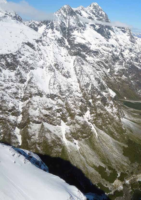
In, out and around Milford   3

                                                                       Eglinton Valley
                                                                      to Lake Te Anau

                                              Lake Gunn

                    Lake Fergus

                Lake Lochie                                                                        Upper Hollyford
                                                                                                  towards Gertrude
                                                                                                 and Homer Saddles

                                                                                  Photo taken at Hollyford, looking south

Departure procedures................................... 22      Noise abatement...................................26
  Via the eastern sectors................................. 22
                                                                Summary............................................26
  Via the West Coast ..................................... 22
  Take-off on Runway 11................................. 22     Abbreviations......................................27

Cover image: Milford Sound aerodrome NZMF

Every effort is made to ensure the information in this booklet is accurate and up-to-date at the time of
publishing, but numerous changes can occur with time, especially in regard to airspace and legislation.
Readers are reminded to obtain appropriate up‑to‑date information.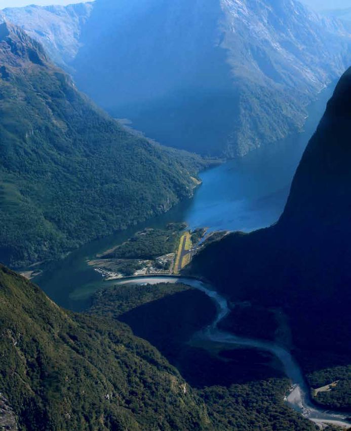
4

Introduction
Milford Sound aerodrome, situated at sea level
on the southwest coast of the South Island,
is surrounded by some of the most majestic
scenery in the world.
But the rugged mountain terrain can create flying conditions ranging from
challenging to downright frightening. Barren Peak rises to over 5000 feet to the
east and Sheerdown Peak to more than 6000 feet less than a mile to the south.
There are at least ten more peaks higher than 6000 feet within a five-mile radius.

The names of features in the surrounding area reflect the difficulties of exploring
this part of New Zealand – Danger Mountain, Terror Peak, Mt Isolation,
Lake Never Never.

This GAP booklet provides a starting point for preflight planning considerations,
and should be read together with In, Out and Around Queenstown and
Mountain Flying.

A current Visual Navigation Chart (VNC) C10 or C14, and AIPNZ, Vol 4
aerodrome charts are essential references while reading the booklet.

Note that a Department of Conservation landing permit is required for Milford.

Avoid peak times
There’s intensive air transport activity generated by the scenic tour operators
at the aerodrome between 1000 and 1600 hrs. In summer, the activity is
more intense and can extend from 0830 to 1715 hrs, with more than 240
daily movements. There can typically be up to 30 aircraft and 20 helicopters
operating into Milford on a regular basis. Aircraft parking space at Milford is
limited. It would be prudent to check with Queenstown or Milford (FIS or local
operators) on the current day’s activity before getting airborne.

To avoid congestion, both on the ground and in the air, it’s recommended that
private flights operate outside the hours above. For those inexperienced in the
area, this is good advice – the workload is a lot easier if there aren’t 20 or so
other nearby aircraft to keep an eye out for and avoid.

The mass arrivals and departures of the tourist aircraft at Milford arise
because the passengers are normally booked on boat cruises in the Sound.
In the summer, extra cruises are scheduled. On some tours, passengers bus in,
and fly out.
In, out and around Milford   5

Milford Sound aerodrome (NZMF), looking north west

6

Milford Sound weather
Pilots unfamiliar with the                            Don’t be deceived
area should consider flying                           Weather inviting a flight to Milford on a
                                                      beautiful day can put a serious ‘fish hook in the
to Milford in favourable                              tail’. You can enjoy pleasant flying conditions
conditions only.                                      to Milford with plenty of visibility. This ensures
                                                      navigation is not so challenging, but then you
It’s important to know about the multiple             find the end of the flight, if landing in Milford,
routes used by regular operators. If the weather      is more challenging. It can be potentially worse
changes unexpectedly, you need escape plans.          than previously experienced anywhere else
On days when there’s a possibility the escape         because of two prevailing wind conditions at
routes will close, it may be safest to stay home.     the aerodrome.

Milford Sound is only 40 NM from Queenstown,
but the main divide has a dominating effect on        South-easterly
South Island weather, often posing problems           In south-easterly conditions, once across
for pilots.                                           the passes from the west, descent will mean
The surrounding mountainous terrain and               encountering turbulence. This SE condition lasts
sea can create changeable climatic conditions.        generally for a day or two immediately following
Often, a flight to Milford may seem suitable          the passage of a front. It provides threatening
at the time of departure, but the weather can         wind shear and sink on approach to Runway 11,
deteriorate markedly in less than 30 minutes.         to an extent that requires appropriate training
                                                      or experience. Otherwise a landing should be
Flying conditions in the mountains are generally      avoided by conducting an overhead flight.
better in the morning, with less likelihood of
cloud, turbulence, and wind. Even an invitingly       If the surface wind is south-easterly, 120 to 150
clear day, however, can harbour trouble in the        degrees magnetic, at 10 knots, check if any of the
form of violent turbulence below the tops.            regular operators are going. The wind strength
                                                      may sound okay, but local knowledge would tell
Study the weather patterns carefully, along           you that, at Milford, this wind direction creates
with the appropriate aerodrome forecasts and          hazards. In these conditions, there may be clear
reports. Invercargill’s weather can give you          blue sky, but lower-level turbulence and sink
a heads-up on deteriorating conditions from           makes flights unpleasant, and a landing difficult.
the south.
                                                      A south-easterly is the worst situation at
If there’s low coastal cloud on the west that’s       Milford. The term ‘south-easterly’ is used
below the height of the eastern passes, then          loosely to describe any wind from a southerly
flight from the east is unlikely to be available,     quarter and the direction of the upper wind –
and particularly risky in deteriorating conditions.   conditions not suited for a novice Milford pilot.
The passage of a southerly front generally            The wind flow can spill out of Arthur Valley;
brings clearing weather on the West Coast.            there can be very white water on the threshold
At Milford, although the sky may have cleared,        of 11, with marked wind shear. There may also
conditions may still not be suitable for landing      be disturbed water off Deepwater Basin at the
until the southerly dies down.                        mouth of the Arthur River. It can be better to land
                                                      on Runway 29 due to its better go‑around option.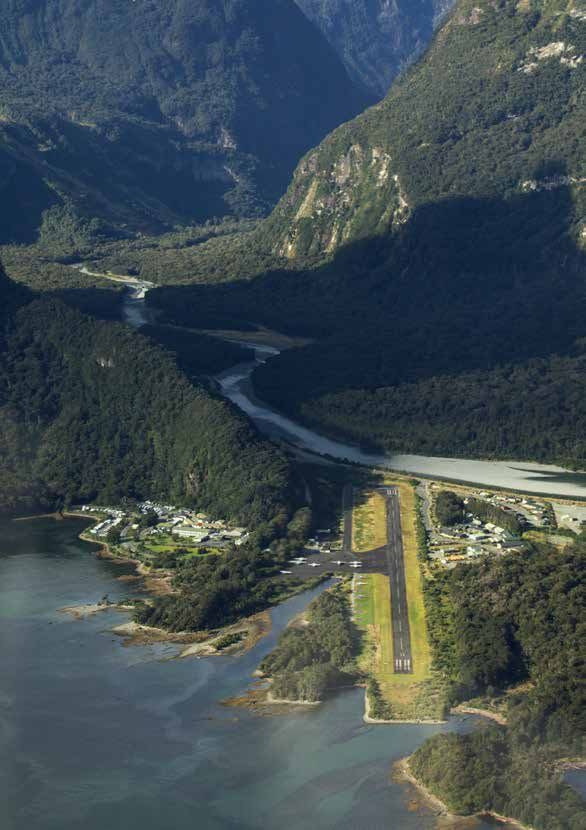
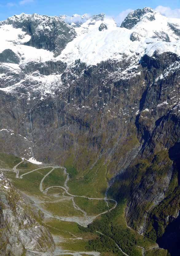
In, out and around Milford   7

Even if the Runway 29 threshold wind is calm,        turn onto the centreline) being careful to
allowing a settled approach, the windsock            watch for, and keep clear of, aircraft on the
halfway along the runway can be straight out         extended downwind leg.
due to wind whistling through the gap in the
                                                     Watch out for aircraft joining directly from
trees on the south side of the runway.
                                                     the Tutoko and Cleddau Valleys.
If the wind is flowing more down the Tutoko
                                                     There can be marked wind shear on the final
Valley, conditions will be different with more
                                                     approach, which passes over high trees,
tailwind and turbulence on the approach to
                                                     the Arthur River, and a stopbank at the
Runway 29. In that scenario, Runway 11 may
                                                     aerodrome boundary.
be a better option for landing, although there
may be considerable sink off the Footstool (the      There’s generally a crosswind from the right
ridge off Mitre Peak). Accuracy of approach is       in these conditions.
extremely important. Again, this is not for the
novice Milford pilot.                                Wind calm
In these conditions, an overflight may be            If surface conditions are calm, landings are
the safest option.                                   commonly made on Runway 11. If an overhead
                                                     join is made, the left-hand downwind and base
Overflights should be 5000 ft or above. Report
                                                     legs are shaped to suit the terrain.
position and intentions, but be aware that flight
service will not normally give traffic information   Take-offs are normally made from Runway 29.
to overflight pilots due to workload.

Sea breeze
In the afternoons, a coastal sea breeze can be
funnelled into Milford with additional venturi
effect. This causes turbulence, shear, lift, and
sink. Landings are then made on Runway 29.

Generally, on descending in calm conditions
in the Sound, a change occurs through
approximately 3000 feet to more turbulent
flight. On final approach to Runway 29, a
quite volatile experience occurs as the wind is
affected by the terrain.

It’s not wise to approach without training or
suitable experience.

The approach for Runway 29 involves a
teardrop turn up the Cleddau Valley. The
downwind leg is extended into the valley
(keeping close to the base of Sheerdown
Peak) up to the junction with the Tutoko
Valley. A left turn is made near the bridge
over the Tutoko River to come back on a              Milford Sound aerodrome, with the
curved final leg (ultimately requiring a right       approach to Runway 29 depicted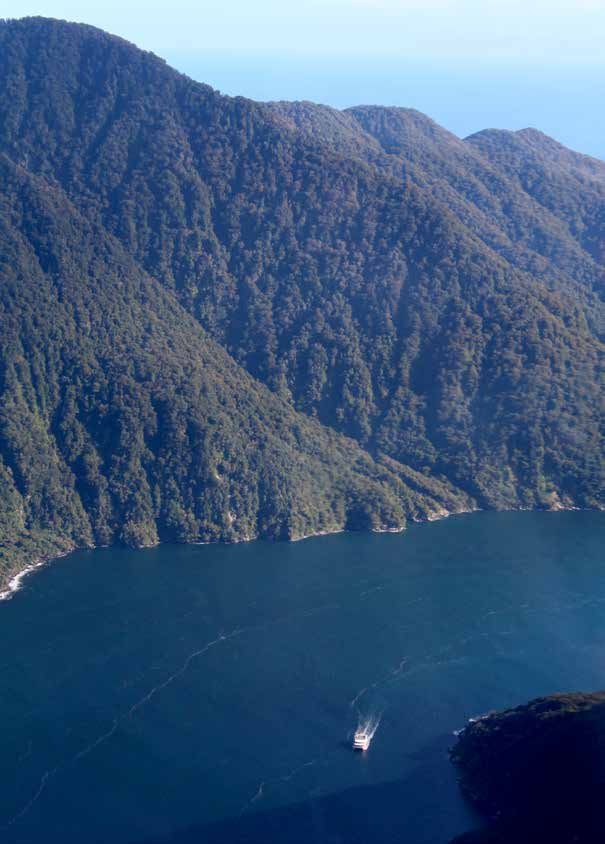
8

Flying to Milford

Preflight planning                                Note that all Queenstown-controlled airspace
                                                  is transponder mandatory.
Before flying anywhere in this area, you
should undergo mountain flying training and       Aircraft must have serviceable radio
have a reasonable amount of mountain flying       equipment capable of two-way communication
experience. (For background information on        on Milford Flight Service and collision-
mountain flying, refer to the GAP booklet and     avoidance frequencies.
associated DVD Mountain Flying, and the GAP
                                                  If possible, plan to start your Milford flight from
booklet Survival.)
                                                  Queenstown (or nearby airfields). This enables
The Milford aerodrome information (in             you to check the latest reports for Milford and
AIP New Zealand, Vol 4) states that pilots who    to seek local knowledge to complement the
have no previous or recent (within the last       reports. Local pilots working for the regular
six months) operating experience at Milford       operators undergo substantial training before
Sound should be briefed by a pilot experienced    taking passengers into Milford. They build up
with and current in, operations to and from the   experience in judging the nuances of weather
aerodrome. A check flight into Milford with an    patterns in the area, and the best routes for
experienced instructor is a safe way to extend    prevailing conditions.
your own experience and capabilities.
                                                  Milford has a higher aerodrome minima
A current VNC C10 or C14 is essential – it has    than most aerodromes in the AIP. If the
the reporting points marked and ensures           actual conditions are at or near the
you have up-to-date detail of the airspace.       published minima, a pilot unfamiliar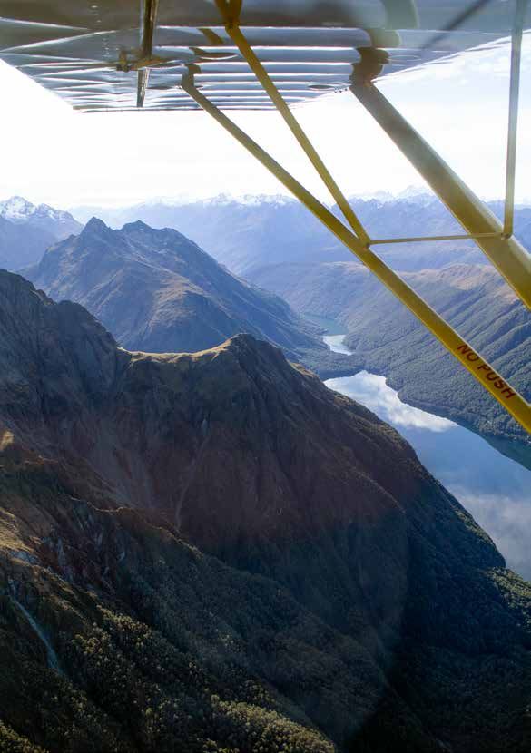
In, out and around Milford   9

                                                             MacKinnon Pass with Lake Mintaro and
                                                                   Clinton Valley in the background

with Milford should not plan to fly there.     • Plan fuel requirements carefully as
The weather is very changeable and could         there’s no fuel available at Milford.
easily deteriorate. Even if you got in, you      An unexpected diversion due to
may not be able to leave safely.                 weather can easily add an extra 30 to
                                                 40 minutes to your flight.
Apart from the Hollyford Valley, most passes
from the east require at least 5000 ft-plus    • Study the reporting points carefully
to enter Milford. Therefore any flight to        before you go. As with any new area,
Milford with a cloud base around 5000 ft is      a lack of local geographic knowledge
not prudent.                                     makes sighting traffic and radio reporting
                                                 unnecessarily difficult.
To rely on the Hollyford Valley as your
only option in and out is not a good idea,     • Study all the Milford Sound aerodrome
particularly in deteriorating weather            pages carefully. They cover all arrival
conditions.                                      and departure procedures in detail,
                                                 and radio procedures for collision
When planning:                                   avoidance.
  • Plan your route carefully (including       • Note the times of intense traffic activity
    alternatives). The extra time spent on       and plan to avoid them.
    the ground pays off in times of high
    cockpit workload.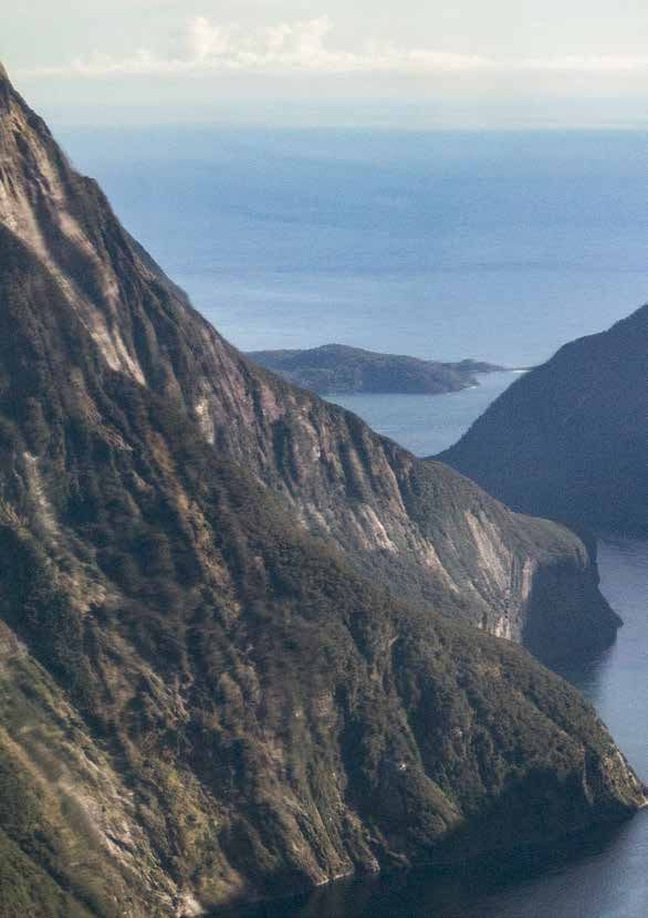
10

Aerodrome flight information service
Milford Sound has an aerodrome flight information
service (AFIS). Make sure you understand your                       Homer
                                                                    Pass
responsibilities, and how AFIS differs from an ATC
service. (Refer to AIP New Zealand and the GAP booklet
Plane Talking.) AFIS is not the same as UNICOM, nor
is it a service providing separation from other flights.
It is able, however, to provide traffic information.

Homer Tunnel
There’s a restricted area, NZR701 Homer Tunnel,
from surface to 8000 feet AMSL, centred on the
Homer Tunnel. This is associated with avalanche risk
and prevention activities – including bombing – to
protect the tunnel, and is activated by NOTAM when
necessary (more likely in winter months).

Preferred routes
Pilots should route to and from the Milford Sound
aerodrome via one or more of the reporting points
shown on the current VNC.

Operators from Queenstown normally depart
Queenstown via Skippers Saddle and Lake Luna, and
then route via the Caples, The Divide area, to Moraine
Creek and Donne, to Gulliver, and out to Dale Point.

Another commonly used route is from Lake Luna to
Harris Saddle (requiring 5500 feet AMSL) then the
Adelaide or Donne Saddles.

When the cloud base is low, the Greenstone Valley,
having the lowest saddle, is possibly the best option.
But be careful, because there are fewer escape
options associated with low cloud. Generally, this
requires continuing down the Hollyford Valley to enter
Milford via the mouth of the Sound. This could be a
useful route on a good day for those inexperienced in
the area, as it’s easy navigation and clear of the typical
flight paths of the tourist traffic.

        Looking toward the Homer Tunnel entrance from the west >>
In, out and around Milford 11 Cleddau Valley
12

                                             Mount Christina

Mount Crosscut

     Homer, looking east toward Queenstown
In, out and around Milford 13 Monkey Flat VRP
14

           Hollyford Valley

                                                                                       Greenstone Valley
                                                     Greenstone Saddle

                                                                         Lake Fergus

                                                                                                      Lake Gunn

Lake Gunn looking toward The Divide and Hollyford Valley
In, out and around Milford 15
Arriving at Milford
If you plan on making a landing, your preparation needs
to be thorough.
But remember, to reduce complexity, you can Accurate position reports are vital. Reports
always overfly Milford and view Fiordland from should include position, level, and direction of
the air without making a landing. flight (and further intentions if necessary).
In some conditions, an overflight may be If you don’t have two radios, try to make your
the only option due to severe turbulence position reports to Queenstown Information
below the tops. (128.9 MHz) at a position where there’s less
likelihood of missing crucial collision-avoidance
Due to traffic density, local operators conduct
calls on 119.2 MHz.
overflights at 5000 ft to avoid congestion in
the Sound. Aircraft should call Milford AFIS on 118.2 MHz
before entering the Milford Sound CFZ. To
Airmanship the east, the boundary is approximately 3 NM
radius from Milford Sound aerodrome (this is,
When possible, it’s a good idea to do a briefing in effect, on the western side of the eastern
refresher while enroute. But as you near passes). All the eastern passes north-west are
Milford, there won’t be any time to study in the 119.2 MHz CFZ. It extends out to 25 NM
the chart and procedures in detail. Planning from the aerodrome in a 10 NM-wide band
your descent, your lookout, and completing centred along Milford. This area encompasses
necessary checks will require non-stop the main arrival and departure routes,
aviating, navigating, and communicating. including the mouth of the Sound, where
This is where your preflight briefing will traffic arriving from different aerodromes may
prove invaluable. Being well-prepared for be merging.
the expected can make it easier to cope with If operating outside the hours of Milford AFIS
the unexpected. attendance, carry out standard unattended
aerodrome procedures on 118.2 MHz.
Communications – position reporting
The Fiordland common frequency zone (CFZ) Other ways to avoid collisions
extends from Queenstown to Milford Sound Landing lights and strobes should be used at
over the area of intensive tourist aircraft all times throughout the Fiordland CFZ.
activity. A collision-avoidance frequency of
119.2 MHz is used in this area. In Milford Note there’s also a requirement to use
Sound, CFZ communications are with Milford landing lights, if possible, within 10 NM of
Flight Service on 118.2 MHz. Within the Queenstown.
Fiordland CFZ, aircraft should make frequent Above all, maintain a good lookout at all
position reports on the collision-avoidance times. This is not easy in unfamiliar terrain,
frequency, 119.2 MHz, and maintain a with the need to constantly refer to the map
listening watch. This frequency is for air-to-air – but keep your eyes out of the cockpit as
communications to enable pilots in the area
much as possible.
to be aware of the presence and position of
other aircraft.16
Arrival procedures Straight-in approaches are always difficult
to judge accurately. If a straight-in approach
The Milford “Procedures and Location”
to Milford’s Runway 11 is misjudged, an early
chart in the Vol 4 aerodrome pages clearly
decision to go around is necessary, due to
illustrates how the aerodrome is restricted
the restricted flight path, rising terrain, and
physically by surrounding terrain.
possible downdraughts in the go-around area.
The cautionary notes point out some of the
hazards associated with operating at Milford. From the eastern passes
As with any uncontrolled aerodrome, joining Aircraft will normally approach Milford from
traffic “must observe other aerodrome traffic the passes to the east, which are only about
for the purpose of avoiding collision and five NM from the aerodrome. Consequently,
conform with or avoid the aerodrome traffic there’s a good deal of height to lose
circuit formed by other aircraft” (rule 91.223). before landing.
Arrival procedures require these aircraft to
Circuit maintain 3000 feet or above, until north-west
Flying a standard circuit pattern is not possible of a line joining Williamson and Pater Points.
due to the surrounding terrain. You still need,
Then continue descent on the northern side of
however, to make normal position reports in
the Sound towards Dale Point. This procedure
the circuit. Landing and take-off directions
allows a gradual descent, which is of benefit to
are dependent on the wind.
passengers. From Dale Point, you should fly on
An aircraft may join directly into the circuit, the southern side of the Sound when inbound
only if: towards the aerodrome, and report passing
Stirling Falls. Cross the line joining Williamson
• joining intentions are advised to Milford
and Pater Points at or below 1500 feet.
Flight Service;
If Runway 11 is the preferred runway, aircraft
• the active runway and aerodrome traffic
may join for a straight-in approach, provided
are identified;
there’s no conflict with existing traffic and
• when joining straight in, or directly provided Milford Flight Service is on watch.
onto downwind or base leg, the aircraft Otherwise position overhead to join left-hand
is sequenced to give priority to other downwind at 1000 feet.
aircraft already in the circuit or joining,
in accordance with the standard circuit If Runway 29 is the preferred runway, join
joining procedure; and left‑hand downwind at 1000 feet.
• when entering, or flying within the circuit, The procedures allow that, if Runway 29 is
all turns are made in the appropriate the preferred runway, aircraft may join for
circuit direction. a straight-in approach provided there’s no
conflict with existing circuit traffic. Otherwise
When joining overhead, it’s extremely
position overhead to join left-hand downwind
important to do so at 1500 feet. There may be
at 1000 feet.
departing traffic up to 3000 feet, and arriving
traffic above 3000 feet. This straight-in 29 approach is not
recommended for the novice Milford pilot.In, out and around Milford 17 Dale Point VRP
18

To Mackinnon Pass
and Balloon Pass

     Mount Pillans
                     Staircase
                                  Green Valley
                                  Traffic from the West Coast

                        Ada VRP
In, out and around Milford 19 Radio communication with Milford Flight Service is lost when in the Tutoko or Cleddau Valleys. When you arrive at the junction of the valleys, which is the late downwind position for Runway 29, other aircraft won’t know you’re there until you’re upon them. Aircraft joining in this manner must keep a careful watch for other aircraft and establish radio contact as soon as possible. If Runway 11 is the preferred runway, aircraft may join left-hand downwind at 1000 feet, provided that there’s no conflict with existing traffic, especially Runway 29 departures. The alternative is to maintain 3000 feet and carry out an eastern passes arrival. From the West Coast area Enter the Sound on the southern side at St Anne Point, reporting position passing Stirling Falls and proceed to join the circuit for the preferred runway, as for the arrivals from the eastern passes. On the ground, park on the western apron. From Arthur Valley Conduct arrival procedures as for the eastern passes, or be at or below 1500 feet on crossing Ada reporting point. Join overhead at 1500 feet for left-hand downwind Runway 29 or at 1000 feet for left-hand downwind Runway 11. There could be aircraft from Te Anau coming in from this direction. On the ground Once on the ground at Milford, be careful to brief your passengers before allowing them to get out, due to the limited apron space and proximity of the runway. Allowing unsupervised passengers near operating aircraft is an unacceptable risk. An area on the northern apron is usually available for itinerant parking.
20

                                                                                 Pyke River to
                                                                                 Alabaster VRP

Departing Milford
A critical factor to consider is, although it may
be possible to land successfully, conditions
may not allow a safe take-off.

The regular operators generally do not       Aircraft performance
take off on Runway 11 and will accept the
                                             Check the aircraft performance graphs for
downwind component on Runway 29 (if
                                             the expected conditions – and for the possible
performance requirements can be met).
                                             worst case scenario. In some conditions at
Otherwise they stay on the ground. The
                                             Milford, it may be preferable to depart from
downwind effect, plus marked wind shear
                                             a downwind position. Remember, you must
after take-off, results in very poor climb
                                             be able to cope with the problems associated
performance.
                                             with mountains, such as terrain clearance,
If a take-off is made from Runway 11,        updraughts, downdraughts, wind shear and
the normal flight path would be into the     the lack of a well-defined horizon.
Cleddau‑Tutoko basin to climb. Taking
                                             Also understand how density altitude
off on Runway 11 is not recommended,
                                             affects your aircraft performance.
however, due to downdraughts and the
                                             For further information, see the GAP
deceptively rising terrain.
                                             booklet Takeoff and Landing Performance.
In, out and around Milford 21
Park Pass Hollyford Valley
Hidden Falls VRP
McKerrow Island VRP
Lake McKerrow, looking toward Hollyford
Routes the Eglinton or Greenstone Valleys). Another
possible route is via Park Pass, leading to
With the onset of deteriorating weather and an
Rockburn and into the Dart Valley (Park Pass
accompanying lowering cloud base, the return
requires 4500 feet and is often the last pass to
journey may be markedly different from a
close in bad weather).
high-altitude inbound flight.
If this low-level choice is necessary, make sure
If weather conditions prevent routing via
you closely monitor the situation – ahead and
the eastern passes or Balloon Pass, the
behind. It may become necessary to return
low‑level route out is up the coast to Martins
to Milford, which could have deteriorated
Bay, then via Lake McKerrow, Hollyford
further. The safest option might be to remain
Valley to The Divide area, then the Caples or
at Milford in the first place.
Greenstone Valleys to Elfin Bay or down the
Eglinton Valley to Te Anau (an altitude of 3500 Accurate judgement of all these factors can
feet is required to get from the Hollyford into come only with experience.22
Departure procedures
Via the eastern sectors
After take-off on Runway 29, turn right to
climb north-west along the northern side of
the Sound. There can be strong ridge lift in sea
breezes. At or before Williamson Point, turn left
to overhead the aerodrome, then proceed en
route. You’ll need to plan ahead to gain height
and reach the 5500 feet necessary to get over
the eastern passes only a few miles from the
aerodrome. Watch for incoming traffic.
Via the West Coast
After take-off on Runway 29, veer right to
climb north‑west along the northern side of
the Sound, not above 1500 feet until west of
Stirling Falls, then proceed en route. Report
passing Stirling Falls and direction vacating
at Dale Point.
Local operators may be heard conducting a
“Mouth‑South” departure where they route
south down the coast from the Sound entrance
to gain height before turning east to return to
Queenstown. This reduces noise for users of
the Milford track.
Take-off on Runway 11
Take-offs are normally made on Runway 29,
unless the downwind component is excessive.
Take-off on Runway 11 has a restricted flight
path into rising terrain and downdraughts
are a hazard. Take-off in this direction is not
recommended.
The procedures give a departure route, after
take-off on Runway 11, of departing direct via
the eastern passes, or of returning overhead
the aerodrome and departing as above.
In practice, take-offs from Runway 11 are
virtually non-existent because of performance
requirements, and are not recommended
because of associated hazards.
Lake Quill >>In, out and around Milford 23
Mount Pillans
Lake Quill
Sutherland Falls24
Mitre Peak
Tasman Sea
St Anne Point VRP
Dale Point VRPIn, out and around Milford 25
Stirling Falls
Mouth of Milford Sound26
Noise abatement
Be a good neighbour and apply noise
abatement procedures. Remember that
noise can be accentuated in an area of
mountains and valleys, and there are
other Fiordland National Park users on
the ground trying to enjoy the beauty and
serenity of the area.
Please maximise your height over the
popular walking tracks (Milford, Hollyford,
Caples, Greenstone, and Routeburn).
Weather permitting, allow at least 1000
feet clearance over the popular climbing
saddles. In particular, remain well clear
of Mackinnon Pass (ie, above 5000 feet
AMSL). Local pilots use Balloon Pass,
when possible, to avoid overflying
Balloon Pass, looking west Milford Track walkers.
Summary
Think carefully about whether you are Don’t be overwhelmed by the magnificent
suitably equipped, experienced, and scenery – keep a good lookout at all
capable of tackling a flight into Milford. times, and pay attention to navigation
and communication. Maintain weather
A full briefing is essential but a check
awareness.
flight with an experienced Milford
instructor is the best way to extend Don’t stay too long – weather awareness
your flying capacity. again. If the sky is clear blue as far as you
can see before landing, it may stay that
An overflight is a safer option for the
way during your stopover. But you can’t
inexperienced pilot.
see bad weather approaching, and weather
Plan, plan, plan. Do your homework. conditions can deteriorate very quickly.
Consider all the necessary factors.
Mornings are generally better weather-
wise. Plan to arrive either before or
after the main influx of tourist aircraft.In, out and around Milford 27
Abbreviations
AC advisory circular IFR Instrument flight rules
AD Aerodrome section of LFZ Low flying zone
AIP New Zealand MBZ Mandatory broadcast zone
AFIS Aerodrome flight information MHz Megahertz
service
NM Nautical mile
AGL Above ground level
NORDO Non radio-equipped
AIP Aeronautical Information
PBN Performance based navigation
Publication
PLA Parachute landing area
ALT Altitude (setting on transponder)
QNH An altimeter sub-scale setting
AMSL Above mean sea level
to obtain elevation when on the
ATC Air traffic control ground
ATIS Automatic terminal RNAV Area navigation
information service
RNP Required navigation performance
CFZ Common frequency zone
SARTIME The time nominated by a pilot for
CTA Control area the initiation of alerting action
CTR Control zone TM Transponder mandatory
DME Distance measuring equipment VFR Visual flight rules
ENR En-route section of VHF Very high frequency
AIP New Zealand
VNC Visual navigation chart
FISCOM Flight information service
VOR VHF omnidirectional radio range
communications
VPC Visual planning chart
FL Flight level
VRP Visual reporting point (VRP names
FSO Flight service officer
are this colour except over photos)
GAA General aviation area
Note: Throughout this booklet all altitudes
GAP Good Aviation Practice (booklet)
are above mean sea level (AMSL) unless
GNSS Global Navigation Satellite System otherwise stated.
Radio phraseology
Radio calls that are clear, concise, consistent, and correct are essential to good communication. We recommend
that you study Advisory Circular AC91-9 Radiotelephony Manual. The AC contains examples of standard
radiotelephony phraseology for use by pilots and air traffic services. See also the GAP booklet Plane Talking.
See the CAA website for Civil Aviation Rules, advisory circulars, airworthiness directives,
forms, and more safety publications. Visit www.caa.govt.nzPO Box 3555
See the CAA website for Civil Aviation Rules,
Wellington 6140
advisory circulars, airworthiness directives,
Tel: +64 4 560 9400 forms, and more safety publications.
Fax: +64 4 569 2024
www.caa.govt.nz
Email: info@caa.govt.nz
In, out and around Milford
was revised April 2019.You can also read