MOBILE MAPPING ON-DEMAND, USING ACTIVE REPRESENTATION AND GENERALISATION
←
→
Page content transcription
If your browser does not render page correctly, please read the page content below
MOBILE MAPPING ON-DEMAND,
USING ACTIVE REPRESENTATION AND GENERALISATION
P.G. Hardy, K.R. Haire, R. Sheehan, P.A. Woodsford
Laser-Scan Ltd,
Science Park, Milton Road, Cambridge, CB4 0FY, UK.
Email: Paul@lsl.co.uk
Keywords: "mobile mapping, generalisation, representation, active objects, OO,
Object-Oriented, Internet, web,interoperability, OpenGIS, on-demand mapping, location
based services".
ABSTRACT
Tomorrow's user will expect to retrieve everyday information easily wherever they are, via
their hand-held wireless appliance (integrated phone plus Internet browser). Much of this
information will have a strong spatial component (where is the nearest?), and will need to be
presented as some form of map. The constraints of the display size and the on-demand nature
of the information retrieval will require the use of dynamic representation, automatic
generalisation and active feature selection to present the vital information to the user without
unnecessary clutter.
This paper overviews the underlying technologies, reviews example implementations,
analyses the impact of this new requirement on the cartographic industry, and highlights the
importance of active object technology in achieving the necessary presentation.
1. INTRODUCTION
1.1 Overview
Although they have been greatly over-hyped, mobile information presentation technologies
such as WAP show the way forward for communication of information to the individual.
When combined with complementary technologies such as GPS and handheld computers
(PDAs), they will provide the heart of the next generation wireless handheld information
appliance. In addition, interoperability protocols from the OpenGIS consortium provide the
framework for bringing together location data from multiple servers, to be combined on the
browser for maximum value.
Recent advances in geospatial technology have shown that Object-Oriented mapping software
based on an active object spatial database provides unique capabilities suitable for the
presentation of location information to the mobile user. The paper uses the Laser-Scan Gothic
object database and LAMPS2 mapping system as exemplars. Examples are taken from a
range of current and prototype Internet web mapping solutions, concentrating on their
strengths for mobile mapping.
Active objects in a spatial object database respond dynamically to the current needs of the
user in a range of ways:
Dynamic representation implemented as object display behaviours allows individual
objects to draw themselves differently according to their surroundings;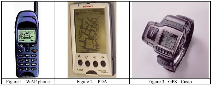
Active object generalisation methods and software agent behaviours derive appropriate
map features for current scale and need;
Object database views are the means by which geographical feature objects can decide
for themselves whether they should be included in a specific map product;
Multiple alternative geometries allow a single attributed object to adapt its shape and
position rapidly to suit the current scale and need.
Distributing the knowledge of selection, generalisation and representation into object
behaviours in this way overcomes many of the problems previously encountered in
embedding the skill of the human cartographer into a software solution.
1.2 The Internet as Information Source
Although the Internet has existed for over 25 years, it has undergone dramatic growth in the
last five years, fuelled by cheap hardware and by the ‘World Wide Web’ as an application.
The web itself is made possible by simple information access protocols such as HTTP and
HTML, which have led to the Internet becoming the major information repository for
mankind. As the majority of human-related information has a location component, it is natural
that map display should become a preferred way of finding and presenting information. This
has led to the rise of ‘web mapping’, as exemplified in the CamMap site
(http://www.CamMap.com/) shown in Figure 8 and described later in this paper, and of
‘mobile mapping’ and ‘location based services’ (LBS).
1.3 The Wireless Handheld Information Appliance (WHIA)
If the growth of the Internet has been dramatic, that of the cellular telephone has been
explosive. Recent figures suggest that of the 500 million mobiles in use in 2001, almost 400
million were sold in 2000. Although recent well-publicised layoffs by major phone
manufacturers show that that rate of growth is not sustainable, the new technology already in
the pipeline will continue to drive future sales. As well as its initial role as a person-to-person
communication tool, it is rapidly gaining ground as a means of enquiring for information. In
addition to voice (which will remain a main information channel), other visual aspects are
developing. WAP (Wireless Application Protocol), was the first such and was hyped beyond
its limited but useful capabilities. Other more capable technologies include the DoCoMo
iMode phones in widespread use in Japan. A WAP phone is shown at Figure 1, being used for
'‘WAP mapping’, within the limits of its screen resolution of 100x50 monochrome pixels.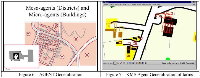
The expansion of the information retrieval role for the mobile phone is currently restricted by
various physical limits, most of which will be eased by future technology already in the pipeline.
The main such are:
Display size and resolution – at the time of writing this is around 100x50 monochrome
pixels, but new display technology will increase this dramatically, giving high
resolutions, colour and foldaway displays. Voice synthesis is also an important
alternative or complement to display for presentation of information.
Keyboard size – small and getting smaller for ease of carrying. Voice recognition is the
vital technology, which will help avoid the need for keying.
Data download rate – for GSM, currently 9600 bits per second (bps), but GPRS being
deployed now gives 100Kbps, and the G3 UMTS third generation licences recently
auctioned will provide 2Mbps. The high costs of the G3 licenses and the bursting of the
‘dotcom bubble’ mean that large-scale availability of G3 services may be further away
than previously thought.
CPU speed – currently far less than in desktop or laptop systems, but Moore’s Law says
that such power doubles every 18 months.
Battery life – improved a lot in the last year, but is in a fight against increased power
consumption from better screens and faster CPUs. New battery technologies on the way
will help.
1.4 Hand-held devices
The third strand of technology contributing to the information revolution is specialised
hand-held devices. The most common is a ‘Personal Digital Assistant’ or PDA, such as the
Psion 5mx, Palm V, and Compaq Aero (see Figure 2). Other related devices are the GPS
(Global Positioning System) receivers. These were bulky, but modern design is reducing them
to very portable (see Figure 3).
The future will bring a new generation of devices, the “Wireless Handheld Information
Appliance”, or WHIA. This will meld features from mobile phones, PDAs, palmtops and GPS
with new screen technologies to give a single optimal tool for communication, location, and
information retrieval, which will be as common as the wristwatch is now. The capabilities of
such devices can already be simulated by combinations of existing tools, such as using a PDA
to access the Internet through an infra-red link to a mobile phone to access on-demand
mapping (see figure 4).
Although much more capable than any one existing handheld device, the WHIA will still
have limitations enforced by the conflicting requirements of less weight, longer battery life
against better screen, faster access. This means that intelligent presentation of information
will become a vital lever for usability.
1.5 Location questions and answers
The WHIA will give the answers to the set of location questions: “Where am I? Where is the
nearest…? How do I get to…?”, and various techniques can be used individually or in
combination to deliver the answers:
Synthesised voice (“at next junction, turn left”). This is particularly important for hands
free situations, such as while driving. The Yeoman Navigation system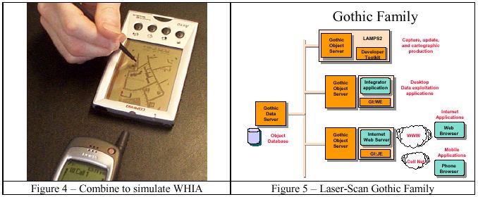
(http://www.yeomangroup.plc.uk/) is a leading example of use of synthesised voice for
in-car navigation.
Text messaging, e.g. by the SMS Short Message Services “in 250m turn left, then …”
Graphical map displayed on screen. In many cases, the map will need to be much more
schematic or diagrammatic than conventional cartography, to put forward the vital
information in the small screen.
Graphical map plus instructions sent to device for printing to paper, or by fax to a nearby
location. Generation of high-quality map content tailored to the request and provided in
formats such as Adobe PDF, is an important intermediate step in this process.
However, in all such cases, the primary source of answers will be a geographic information
server. This paper contends that an active object database is key to finding and presenting the
requisite geographic information in a clear and concise manner.
2. ACTIVE OBJECTS
2.1 What are Active Objects?
The Object-Oriented (O-O) paradigm swept through the software industry many years ago.
O-O is a logical way of modelling the real world within a computer system. All modern
software languages (C++, Java) are built around the four key O-O concepts, of encapsulation,
referencing, inheritance, and polymorphism.
Encapsulation means that data and behaviour are not separated, but encapsulated together
within objects that respond to messages sent to them.
Referencing means that objects can have direct knowledge of related objects (a river
‘flows from’ a spring).
Inheritance means that the object classes can gain capabilities from multiple superclasses,
such as canals inheriting from ‘transportation’, and from ‘water’. This allows modelling
the family structure of the world (a church is a kind of a public building, which is a kind
of a building, which is a kind of a man-made structure).
Polymorphism means that different classes can respond to the same message with an
appropriate behaviour (click on a factory and click on a road, and get different description
types and different highlighting).
A new generation of spatial database, GIS and mapping systems is adopting O-O concepts
and applying them to storage, retrieval, analysis and display of location-related information.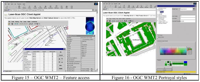
This paper concentrates on the Laser-Scan Gothic family (see Figure 5) of spatial software,
built around the Gothic O-O spatial database [Hardy 1999b].
2.2 Characteristics of active object spatial database mapping system
A Gothic database mapping system has the following characteristics:
Object database - provides efficient storage and retrieval of spatial objects
Object Data Model (Schema) - allows modelling of the real world entities and their
relationships
Continuous mapping (no sheet boundaries) - provides the area wanted at the scale
requested
Topological structure – knows about connectivity, adjacency
Object database views allow intelligent selection of subsets of objects for current purpose
Active representation provides appropriate cartography (see below)
Active object generalisation methods derive appropriate map features for current scale
and need
Validation methods ensure data integrity
Open architecture allows access from workstation, desktop, web browser, or mobile
browser
3. ACTIVE DISPLAY
3.1 Display Methods
A key aspect of O-O mapping is the use of display methods for all visualisation. Instead of
the application having fixed rules about representation, or using a static table of styles, all
drawing is done by sending a message to each relevant object saying ‘draw yourself’. The
response to the message is to execute the object’s ‘display method’, which can use the power
of the object database and spatial toolkit to decide what to do. It can:
Decide to draw or not to draw itself, dependent on scale, specification, and surroundings
Use a rich set of representation styles (line patterns, area fills, symbols)
Change type according to scale – area object may draw itself as point symbol if it is too
small at this scale
Use a different ‘geometry’ (shape) according to scale, showing less detail at smaller scale
Draw itself more than once in different styles, e.g. to achieve road casings, or text labels
Move itself into clear space to avoid edge of map or other collisions
Modify its representation according to scale and surroundings; e.g. shorten label to match
length of road
All of these techniques are applicable to Web mapping and mobile mapping, as in the
examples below.
4. GENERALISATION
4.1 Active Object Generalisation
Generalisation is the science (and art) of exaggerating those aspects that are important for this
particular map purpose and scale, and removing irrelevant detail that would clutter the map
and confuse the user. Generalisation has traditionally been a hard task to automate, being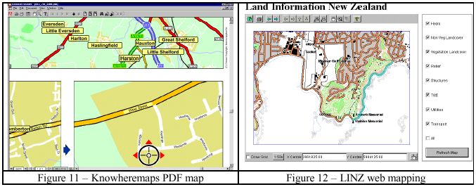
dependent on the skills of the human cartographer. People have tried for years to build
centralised 'knowledge bases' of generalisation rules, with very limited success. In such
systems, the map features themselves have just been passive items containing coordinates and
attributes, acted upon by the centralised rules [McMaster, 1991].
In the Object-Oriented world, this is turned upside down. The map features themselves
become objects that have generalisation behaviours defined in the database schema. The
application itself becomes much thinner, and contains no knowledge about what, how, or
when. It merely provides a framework for invoking and sequencing the generalisation
processes by sending messages to selected objects [Ormsby and Mackaness 1999].
Gothic LAMPS2 includes an Object-Oriented generalisation facility, which allows the user to
define the strategy for generalisation in terms of methods on the object classes [Hardy 2000].
Base object classes are provided which supply generalisation process methods for
multi-object combinatorial operations (aggregation, typification, and displacement) and others
for single object generalisation (collapsing, refinement, exaggeration and simplification).
Note that these are implemented as behaviours of the objects in the database, not as
commands within a program.
Kort & Matrikelstyrelsen (the Danish state mapping agency) is using LAMPS2 in this way to
derive 1:50K mapping from a 1:10K sourced database. The generalisation flowline makes
considerable use of active object views using spatial query, to identify objects for generalisation.
An example is to delete all minor roads less than 2km long, which have a dead end and do not
have buildings within 100m of the dead end.
In the future, increased computational power and improvements in software techniques will
allow such active object generalisation to be done in real time, on-demand to satisfy a user
request for appropriate mapping on his Internet browser or WHIA. Until then, the techniques
are still very useful, but need to be applied in advance to produce a set of ‘usages’, and the
results stored. The object database allows storage of multiple alternative geometries, so you
can have one object (e.g. Trinity College), with one set of attributes, but with several
alternative sets of coordinates, each suitable for a particular scale band (see Figure 10).

4.2 Agent Generalisation
The power of object generalisation has been greatly enhanced by the AGENT project on
multi-agent generalisation. This project [Lamy et al, 1999] was a collaboration under the
ESPRIT programme (LTR/24939). It involved Laser-Scan as providers of object technology
together with a national mapping agency (IGN France) as prime contractor, and academic
partners (Universities of Edinburgh & Zurich, and INPG Grenoble). Some partners provide
in-depth knowledge of generalisation algorithms, while others provide insight into
multi-agent modelling. The contract involved 48 person years of effort over a 3-year period.
In this context, agents are self-aware active software objects that co-operate, subject to a set
of constraints, to achieve a goal. For map generalisation, it is the geographic objects such as
houses and roads, which become active agents and co-operate through simplification,
typification and displacement of themselves to achieve a cartographically acceptable
generalised result. Figure 6 shows co-operating meso-agents handling urban blocks,
communicating with the micro-agents that are the buildings and roads.
The fruits of the project have been implemented in the Laser-Scan Gothic LAMPS2 mapping
software, and are now being productised and commercialised. The first customer is Kort &
Matrikelstyrelsen, which is relying on the active agent capabilities for applying its rules on
building generalisation, including handling of rural farms. Figure 7 shows the original data in
outline and the generalised output in solid, including the effects of aggregation, elimination,
typification, and displacement.
Agent-based generalisation achieves two major steps forward:
An individual micro-agent (e.g. a building) tries different algorithms, keeping the results
if the situation is better, discarding and trying different ones if the situation is worse, so
avoiding using the same tool globally.
Meso-agents coordinate generalisation across sets of objects, so avoid consequential
conflicts and retain gestalt (the overall coherence).
The philosophy underlying the AGENT project generalisation mechanism is for the designer
to define how the map should appear rather than defining how to achieve it (declarative rather
than imperative). Each agent then tries to improve its happiness during an agent life-cycle,
which encompasses:
Measures – implemented as object methods, these assess the tangible state of the feature.
Constraints – implemented as objects, these return the degree of unhappiness for each
aspect of state.
Algorithms – implemented as methods, these change the state, and (hopefully) improve
the situation
Plans – dynamic lists of values, these determine the choice and order in which algorithms
are executed.
Re-evaluate – part of the lifecycle method, this determines if the previous plan was a success
or not, and if not will backtrack the state in order to try another plan.
See the paper referenced at the head of this section and [Ruas 2000] for more information on
the Agent project. Like the active object generalisation techniques described in the previous
section, these agent techniques are to be used at present in preparing generalised versions of
objects to be used for different scale enquiries. In the future, they will be applied in real-time
to satisfy mapping requests from Internet browsers or WHIAs.
5. WEB MAPPING EXAMPLES
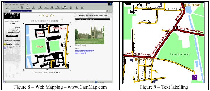
5.1 CamMapCamMap is a highly interactive web map of the area around Cambridge UK. In it, all the objects can be asked to describe themselves, and many (including all pubs, colleges and many public buildings) do so by providing web links to images and related web sites (e.g. for Kings College as shown in Figure 8). The site is free, so try it out yourself (http://www.CamMap.com/). It uses a variety of active object generalisation techniques to present data from a continuous object database at different scales while retaining clarity. Figure 9 shows intelligent generalisation and positioning of text labels. Road numbers have been suppressed where there is insufficient room. Road and pub names have been positioned so that they don’t fall over the edge of the window or over important detail. Figure 10 shows automatic selection of an appropriately pre-generalised geometry for a college according to viewing scale. The combination of these techniques produces a legible map presenting the maximum information, for any requested location at any requested scale, within seconds. 5.2 Location Mapping A commercial web site (http://knowheremaps.com/) has been launched to provide location mapping from an object database. It has national coverage sourced and derived from Ordnance Survey digital map data. It allows lookup of an address by text or by postcode, and can provide a sequence of three location maps at increasing scales, leading the user to the desired location. As well as the on-screen version, the user can request a print-quality map which is delivered in Adobe Acrobat PDF format, for printing at A4 (Figure 11). Both map types are produced using active object representation and generalisation from a continuous object database. The selection of content for the map is determined each time to suit the request, and dynamic label generation and positioning is applied.
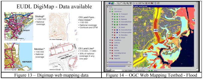
5.3 LINZ
Land Information New Zealand already hold the master data for their 1:50K national topographic
database in a single continuous Gothic dataset administered with LAMPS2, supporting on-demand
hardcopy mapping. More recently, they have asked Laser-Scan to serve a copy of the data from
Cambridge England to the Internet for use by NZ government departments. The web
application uses a Java applet for better interaction than can be achieved with just HTML.
Hardcopy output is still available via download of a generated PostScript file covering the
area of interest, and will shortly be available as high quality Adobe PDF for viewing and
printing. Display methods on the objects in the database choose if and how to draw
themselves, to provide a clear map at a variety of scales (See Figure 12). NZ has recently
chosen to make its topographic data freely available (as in the USA) rather than charging
copyright fees. Topographic mapping of this type will become a valuable framework and
backdrop for handheld spatial information retrieval in the future, for those countries that have
the foresight to release their mapping in this way.

5.4 EDINA Digimap
EDINA Digimap, which is hosted at Edinburgh University Data Library (EUDL), provides on-line
access to OS digital mapping (250,000 map sheets worth) for the UK Higher Education
Community (Universities and Colleges).

The current system is a limited prototype and EDINA is currently re-engineering Digimap to
use Laser-Scan Gothic software, for deployment in 2001. The active object dataset (Figure 13)
underlying the new Digimap will be one of the largest continuous map databases in the world
and will be an excellent testbed for future access to such information from WHIAs. The
continuous dataset and active object representation are key to providing good cartographic
quality for demands for arbitrary sized areas of mapping at different scales.
An important capability of the Digimap system is that when the user has browsed and chosen
the needed area, scale and content, then the results can be provided in different media forms. In
addition to the browser screen, the map (complete with legend and other marginalia) can be
downloaded in PostScript or Acrobat (PDF) format for quality printing, or as feature data in
common formats (Shape, DGN, MapInfo, NTF) for further analysis in a GIS.

6. INTEROPERABILITY

6.1 OGC Web Mapping
The OpenGIS Consortium (http://www.OpenGIS.org/) brings together software suppliers,
spatial data suppliers, and major government agencies to define protocols and interfaces for
interoperability. In particular, it has defined three APIs (GetCapabilities, GetMap, and
GetFeatureInfo), that together allow spatial data from multiple sources to be displayed
together in a web browser. These APIs evolved in Web Mapping Testbed 1 (WMT1) and
subsequently refined and adopted as the OpenGIS Web Map Server Interface Implementation
Specification.
In WMT1, transportation data from a Laser-Scan Gothic object database was combined with
satellite imagery, terrain models, flood predictions, and emergency capabilities from other
servers, in a simulation of a hurricane landfall over Mobile, Alabama (Figure 14). Once again,
the active object selection and representation of Gothic allowed clear display. In the future,
Internet Browsers and WHIAs will be a central way of disseminating such emergency
information, and presenting it to the user in a clear manner.

The recently completed Web Mapping Testbed 2 (WMT-2) has advanced the specifications in
the areas of feature retrieval, portrayal and symbology, catalogue metadata and security. The
separation of the architecture into a Map Server and a Feature Server lays the foundation for
update over the web. Figure 15 shows OSGB data being served from an object database using
OGC protocols, and with feature query. Figure 16 shows an interface for setting the graphical
portrayal from a web browser, and display of OSGB DNF object data.

7. MOBILE MAPPING
7.1 WAP maps The small screen of current WAP phones limits their use for presenting location information graphically, but with intelligent object selection and representation as described in earlier sections of this paper, useful results can be shown. Figures 1 and 17 show a WAP phone displaying information from CamWAP (http://wap.CamMap.com/) an alternative view of the CamMap web mapping site. CamWAP uses the same active object dataset, but different display methods, to enhance clarity on the low-resolution monochrome screen. An example is the use of automatic text haloing (Figure 18) to erase background and clear space for the important text labels. The CamWAP implementation builds on research collaboration between Laser-Scan and the Department of Geography at Edinburgh University. 7.2 Mobile cartography For maximum usability, the cartography for small screen mobile devices must be different to that of paper maps in a number of ways: Content tailored to current request and to user’s profile Irrelevant detail suppressed, and lesser information generalised. Important detail exaggerated for clarity Diagrammatic or schematic, rather than artistic representation Dynamically aligned to direction of travel or to important landmark rather than North up. 8. CONCLUSION The rise of the Internet has already changed the way that many users access spatial information. No longer is the printed map the primary medium. The union of the mobile phone with the PDA and other new technology will produce the ‘WHIA’, a Wireless Handheld Information Appliance, providing the ‘mobile Internet’. WHIAs will become over the next few years the central medium for information retrieval, particularly location-related information in the form of active maps. This shift from paper hardcopy to mobile screen softcopy will greatly affect the nature of the cartographic business. Major parts of the knowledge and skill of human cartographers will need to be embedded in real-time generalisation software (using active representation and intelligent spatial feature generalisation) and in pre-prepared generalised ‘usages’ within digital databases. Object-Oriented generalisation and software agent techniques provide an exciting new framework for generation of clear derived mapping products from detailed master spatial databases. Active object technology in the information server is crucial to on-demand retrieval and clear presentation of the requisite information in the form of an active map on the Internet browser, mobile phone, or WHIA, tailored to the user’s current need.
ACKNOWLEDGEMENTS
Some content of this paper is updated from that of a paper [Hardy & Haire 2000] by two of
the authors given at the ICA workshop on generalisation and on-demand mapping in
Barcelona in November 2000. The support of the members of the AGENT consortium, for the
material on generalisation, is also acknowledged.

REFERENCES
Hardy P.G., 1999a, "Map Generalisation - The Laser-Scan Way", on-line paper at
      http://www.Laser-Scan.com/papers/lamps2mapgen.htm
Hardy P.G., 1999b, “Active Object Techniques for Production of Multiple Map and Geodata
      Products from a Spatial Database”, ICA/ACI Conference Proceedings, August 1999,
      Ottawa,               Canada,               or              online             at
      http://www.Laser-Scan.com/papers/ica99gwg/pghica99gwg.htm
Hardy P.G. and Haire, K., 2000, “Generalisation, Web Mapping and Data Delivery over the
      Internet”, ICA workshop, November 2000, Barcelona, Spain, or online at
      http://www.Laser-Scan. com/papers/barcelona2000pgh.pdf
Hardy P.G. 2000, “Multi-Scale Database Generalisation For Topographic Mapping,
      Hydrography And Web-Mapping, Using Active Object Techniques”, IAPRS, Vol.
      XXXIII, ISPRS Amsterdam, Netherlands, July 2000, or online at
      http://www.Laser-Scan.com/papers/ isprs2000pgh_1436.pdf
Lamy, S., Ruas, A., Demazeau, Y., Jackson, M., Mackaness, W.A. and Weibel, R., 1999,
      “The Application of Agents in Automated Map Generalisation”, 19th ICA/ACI
      Conference, Ottawa, 160-169.
McMaster, R.B., 1991, "Conceptual Frameworks for Geographical Knowledge" in Buttenfield
      B.P. and McMaster R.B. "Map Generalisation: Making Rules for Knowledge
      Representation", Longmans.
Ormsby, D., and Mackaness, W. A., 1999, "The Development of Phenomenonological
      Generalisation within an Object Oriented Paradigm": Cartography and Geographical
      Information Systems, v. 26, p. 70-80.
Ruas A., 2000, “Project AGENT: Overview and Results of a European R&D Project in Map
      Generalisation”, ICA Workshop, November 2000, Barcelona, Spain.

[Original 2000-04-22, Revised 2000-04-27]
You can also read