MOGEO, A MOBILE APPLICATION TO PROMOTE GEOTOURISM IN MOLISE REGION (SOUTHERN ITALY) - MDPI
←
→
Page content transcription
If your browser does not render page correctly, please read the page content below
resources
Article
MoGeo, a Mobile Application to Promote Geotourism
in Molise Region (Southern Italy)
Francesca Filocamo , Gianluigi Di Paola * , Lino Mastrobuono and Carmen M. Rosskopf
 Department of Biosciences and Territory, University of Molise, Contrada Fonte Lappone, 86090 Pesche (IS), Italy;
 francesca.filocamo@gmail.com (F.F.); lino.mastrobuono@ordinegeologimolise.it (L.M.);
 rosskopf@unimol.it (C.M.R.)
 * Correspondence: gianluigi.dipaola@unimol.it; Tel.: +39-0874-404168

 Received: 18 February 2020; Accepted: 9 March 2020; Published: 12 March 2020

 Abstract: Geotourism represents a powerful and new form of sustainable tourism that has rapidly
 expanded worldwide over the last decades. To promote it, the use of digital and geomatic tools
 is becoming of increasing importance. Especially mobile information represents one of the most
 efficient and smart ways to bring geotourism closer to a wide audience. This applies in particular
 to rural and inner areas, where the exploitation of geoheritage can represent a crucial resource for
 eco-friendly and sustainable tourism development. With the aim to promote geotourism on a regional
 scale, we have implemented a mobile devise application for Molise region, tested in the Alto Molise
 area. This application, called MoGeo App, aims at providing diversified geotourism information that
 combines geologic attractions (geosites and geologic itineraries) with other possible tourist attractions
 (other sites of natural and cultural interest), to respond to differentiated interests and needs of a wide
 audience. Besides geotourism purposes, the structure of MoGeo App can be used also for other
 purposes such as educational targets, by adapting contents and language. It appears to be a flexible,
 easily updatable digital tool, adaptable to various target groups, as well as other regional contexts,
 both inside and outside of Italy.

 Keywords: geology-based tourism; geosites; geoheritage; cultural heritage; web-GIS; smartphone;
 Alto Molise

1. Introduction
      Geotourism, understood as a form of tourism that specifically focuses on geology and
landscape [1–6], represents a powerful and relatively new form of sustainable tourism [7,8]. It has
rapidly expanded over the last decades [4–9] all around the world [5,7,10] and become a substantial
part of the overall tourism offer [4], as well as an important research direction (e.g., [6,10]).
      Geotourism focuses on geoheritage and therefore on geosites that are the most essential part
of it [5,9,11–13]. It represents an important alternative or integration to more traditional forms of
tourism, such as sun and sand tourism, and cultural tourism. Furthermore, it can become an important
economic resource for countries and regions that are characterized by a rich natural heritage and great
geodiversity (e.g., [8,14–18]). Especially in rural and inner areas, the exploitation of geoheritage can
represent a crucial resource for eco-friendly and sustainable tourism development. Here, traditional
and mass tourist destinations are generally scarce or lacking, and major tourist attractions are typically
related to the geodiversity and naturalness of the landscape [19–23]. It is in such areas that the
geo-landscape and the related geodiversity, biodiversity and cultural values [5,24,25] become important
drivers for the local and regional economy.
      Geotourism, both in a pure sense and characterized by the integrated fruition of geological sites
and other places of interest (natural, historical, archaeological, etc.) [20,26,27], can be of high interest

Resources 2020, 9, 31; doi:10.3390/resources9030031                               www.mdpi.com/journal/resources
Resources 2020, 9, 31                                                                                 2 of 20

for various target groups [23] and especially for families. Families, in fact, must often turn to tourist
forms and offers that take into account differentiated interests and needs of family members, including
simple enjoyment and relaxation, as well as the desire to receive stimuli to learn something about and
better appreciate the natural and cultural landscape [28–30].
      The promotion, organization and exploitation of tourist offers now make increasing use of digital
information sources (especially tourism websites) [31–33], not only in relation to the choice of tourist
offer, travel and accommodation organisation, etc., but also in relation to the description and illustration
of tourist attractions. This is particularly true also for geotourism [33]. Especially in the field of
geoheritage conservation, management and promotion, the use of internet, digital and geomatic tools is
becoming of increasing importance [33–37], even if geotourism is still being promoted little online [33].
Among such digital tools, especially the use of mobile phone devises and related applications to receive
tourist information has experienced very recently a wide and rapid diffusion [38–41]. However, despite
of the elevated potential and specific strengths of digital mobile tools (easy to transport, multi-sensorial,
etc.) [42], there is still little use in the field of geotourism promotion and tour guiding [33,42–45].
Especially the scarce diffusion of app-based mobile tour guides (AMTG) [46] is surely at least partially
due to the possible limitations related to the use of mobile phone applications [44], which must be
carefully considered and best reduced. While keeping in mind such limitations, it is clear that mobile
phones are already or will quickly be the most important interface between visitors/tourists and
tourism contexts.
      In geotorism field [34], three main types of applications can be distinguished: (1) applications
that are based on georeferencing and mapping of geotourism assets, taking advantage in particular
of recent developments in web mapping and mobile data access of maps (e.g., [42]); (2) applications
that return 3D models based on photogrammetry, laser scanning or real-time observations of natural
phenomena through a webcam (e.g., [47]); (3) applications that make interpretations using Augmented
Reality (AR), a process that enriches discovery through digital media or virtual reality technologies
creating a virtual universe that helps to imagine everything (e.g., [48]). These typologies can also be
combined among them and coexist together [34].
      Convinced that mobile apps can strongly support the promotion of geotourism, especially in rural
and inner, less urbanized areas, we have implemented a mobile phone application that is illustrated
in this paper. This application refers to the first type and aims at providing diversified “geotourism”
information that includes not only the geologic attractions (geosites and geologic itineraries) but also
other possible tourist attractions (other sites of interest) to respond in this way to different interests
and needs of users, especially of families.
      The application we propose should operate on a regional scale or on smaller areas. To develop
it, we have chosen the Molise region. This region offers on a relative small area a representative
view of the major geological-geomorphological and landscape features that typically characterize the
central-southern Apennines [18]. It is characterized by a high geodiversity, and a regional inventory
of geosites is already available [49]. However, the divulgation of geosites in the Molise region is
only scarcely developed and restricted to some notions about geosites in leaflets directly distributed
by the regional “Service for Tourist Promotion and Relations with Molisans in the World”, and the
online information provided by some institutional websites [50–52]. Regarding the promotion of
geotourism at the regional or sub-regional scale, specific products are totally lacking. Some associations,
essentially the ones promoting respectively the rocky spurs, so-called Morge, in Molise region,
the Guardiaregia-Campochiaro Oasis and the Collemeluccio-Montedimezzo Alto Molise Biosphere
Reserve [53–55], provide only short information about some geosites and only in Italian, and/or
promote trekking activities and itineraries that include some of them. Besides this, some scientific and
popular publications (e.g., [18,20,21,56,57]) have been produced with the aim of promoting geosites
and geotouristic itineraries of specific areas of the Molise region, such as the Matese area, the Mt.
Mainarde-Alto Volturno area and the Alto Molise area.
Resources 2020, 9, 31                                                                                                       3 of 20

      To start our project, we have selected the Alto Molise area (AM, Figure 1a), one of the seven major
physiographic units in which the Molise Region has been subdivided mainly based on geological
and orographic-hydrographic characteristics [21,49,58]. The main reasons for this choice are: the Alto
Molise area has a small surface area, but is characterized by (i) a geological-geomorphological context
that is representative for the history of the central-southern Apennines [18], and (ii) a high geodiversity
and a significant number of geosites of different scientific interest. The Alto Molise area is also rich
in natural protected areas, as well as important architectural, historical and archaeological sites, and
retains important traces of ancient agro-pastoral traditions and crafts. In fact, the data collected during
the regional geosite inventory activities [49] and several studies carried out to promote its geotouristic
exploitation [18,20,57] have allowed to point out also its geographical features and traditions, as well
as historical, archaeological and faunistic-floristic aspects, highlighting its rich natural and cultural
heritage [57]. Therefore, the knowledge already available makes the Alto Molise area a good starting
  Resources 2020, 9, 31                                                                            4 of 22
point to develop the application.

        Figure1. (a)
      Figure     1. The
                     (a) Molise   regionregion
                           The Molise      and its subdivision     in seven macro-areas.
                                                    and its subdivision                      M-MV-AV = M-MV-AV
                                                                               in seven macro-areas.       Mainarde-Monti=
      diMainarde-Monti
         Venafro-Alto Volturno,       MBS    = Matese-Conca       di  Boiano-Sepino,     MF
                             di Venafro-Alto Volturno, MBS = Matese-Conca di Boiano-Sepino,  =  Montagnola     di Frosolone,
                                                                                                                   MF =
      AM   = Alto Molise,
        Montagnola           MC = Molise
                       di Frosolone,  AM = Centrale,
                                             Alto Molise, BMMC = Basso   Molise,
                                                                  = Molise        FC =BM
                                                                             Centrale,   Fascia  Costiera;
                                                                                            = Basso        (b)FC
                                                                                                     Molise,   Altitude
                                                                                                                 = Fasciaand
      drainage
        Costiera;network    mapand
                   (b) Altitude  of the  Alto Molise
                                      drainage   network macro-area
                                                            map of the with  theMolise
                                                                          Alto   location  of the 17with
                                                                                        macro-area   assessed   geositesofand
                                                                                                          the location
      the other
        the     sites of interest;
            17 assessed   geosites (c)
                                    andPie
                                         thechart
                                             otherillustrating   the assessed
                                                     sites of interest; (c) Pie types of geosites and
                                                                                chart illustrating     related percentages,
                                                                                                   the assessed  types of
      based  on primary
        geosites            scientific
                  and related   percentages,      (G = on
                                       interestsbased    Geomorphology,
                                                            primary scientificS = Stratigraphy,
                                                                                  interests (G =SG   = Structural Geology,
                                                                                                   Geomorphology,     S =
         = Sedimentology,
      SeStratigraphy,          H = Hydrogeology).
                        SG = Structural   Geology, Se = Sedimentology, H = Hydrogeology).

2. The Test Area
    The Alto Molise area (AM, Figure 1a) has a surface area of 452 km2 and is located in the
northwestern sector of the Molise region [20,21]. It is a macro-area particularly rich in geosites,
Resources 2020, 9, 31                                                                                              4 of 20

in total 17 (Figure 1b, Table 1) of the 100 assessed through the regional geosite inventory carried out
by the Department of Biosciences and Territory of the University of Molise in partnership and on
behalf of the Molise Region [18,49]. During this inventory project, the Molise geosites have been
assessed by using a quantitative method that allowed to determine their representativeness, rarity,
the scenic-aesthetic, historical-archeological-cultural, and vulnerability values. Based on the assessed
values, the used method allowed to calculate for each geosite the so-called “Intrinsic Value of the Site
of Geological Interest” (IVSGI) [18], corresponding to the weighted sum of representativeness, rarity,
and scenic-aesthetic values.

        Table 1. Code, name, main scientific interests, and estimated relevance of the Alto Molise geosites.

              ID                               Name                             Scientific Interests   Relevance
              D1                       Capo di Vandra spring                      Hydrogeology         Regional
              D2                       Mt. Miglio monocline                      Geomorphology         Regional
              D3        Mt. Pizzi deep-seated gravitational slope deformation    Geomorphology         Regional
              D4                   Mt. di Mezzo morphostructure                  Geomorphology         Regional
              D5                         Rio Verde springs                        Hydrogeology         Regional
              D6                Rocky ledge of the S. Luca Hermitage             Geomorphology         Regional
                                                                                 Geomorphology
              D7                Mt. Campo –Mt. S. Nicola monocline                                     National
                                                                                Structural geology
                                                                                   Stratigraphy
              D8                   I Colli Agnone Flysch outcrop                                       Regional
                                                                                  Sedimentology
                                                                                  Stratigraphy
              D9                     Morge of Pietrabbondante                                          Regional
                                                                                 Geomorphology
                                                                                Structural geology
             D10                        Mt. Ingotta anticline                    Geomorphology         Regional
                                                                                   Paleontology
             D11                       Verrino Stream spring                      Hydrogeology           Local
                                                                                   Stratigraphy
             D12           Agnone Flysch outcrop of Castelverrino village                              Regional
                                                                                  Sedimentology
             D13                    Pescopennataro fault planes                 Structural geology     National
             D14                      Verrino Stream waterfalls                  Geomorphology         Regional
                                                                                   Stratigraphy
             D15                   Cogoli walls of Agnone village                                      Regional
                                                                                  Sedimentology
             D16                        Vomero Resurgence                        Geomorphology         Regional
             D17          Limestones with pyrite nodules of Poggio Sannita        Sedimentology        Regional

     The Alto Molise geosites, based on their primary scientific interest, refer mainly to the
geomorphology or stratigraphy type (Figure 1c), although many of them have multiple scientific
interests (for example Geomorphology-Structural geology, Table 1). The estimated relevance of the
Alto Molise geosites [57] is mostly regional, national or local, instead, for three of them (Table 1). Most
of the Alto Molise geosites (14) are already included in the Italian Geosites Inventory managed by
ISPRA [52].
     The Alto Molise area is characterized by a mainly mountainous and hilly landscape, whose major
peaks are Mt. Campo (1746 m) and Mt. Capraro (1730 m) (Figure 1b), and by a few low-lying flat
areas, such as the valley floors of the Trigno and Sangro rivers, which are the major watercourses in
this area (Figure 2). Most of the outcropping bedrock is part of a sedimentary succession referred to
the Molise pelagic basin domain, Oligocene to Late Miocene in age, which is interposed between the
Apennine [59] and the Apulia carbonate platforms [60,61]. This succession is mainly composed of four
geolithological units (see Figure 2): Varicolored clays and marls (10), Limestones and marls (9), Clayey
marls and limestones (7) and Siliciclastic deposits (6). Units 7 and 9 form the main mountain ridges,
and Unit 10 the hilly areas surrounding the mountain ridges. Finally, Unit 6 crops out widespread in
the valley incisions of the Sangro River and Verrino Stream (Figure 2).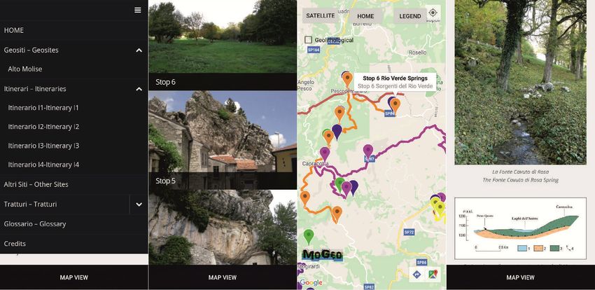
Resources 2020, 9, 31 5 of 20
Resources 2020, 9, 31 6 of 22
Figure
Figure 2.2. Geological
Geological sketch
sketch map
map of
of the
the Alto
Alto Molise
Molise area
area (modified
(modified from
from Vezzani
Vezzani et et al. [62]).(1)
al. [62]). 1) Fluvial
Fluvial
deposits
deposits (Holocene),
(Holocene),2)(2)Slope
Slopedebris (Late
debris Pleistocene-Holocene),
(Late Pleistocene-Holocene), 3) Fluvial-palustrine
(3) Fluvial-palustrinedeposits (Late
deposits
Pleistocene-Holocene),
(Late Pleistocene-Holocene),4) Limestones and polygenic
(4) Limestones and polygenic conglomerates
conglomerates (Early-Middle
(Early-Middle Pliocene), 5)
Pliocene),
Siliciclastic deposits (S. Bartolomeo Flysch, Middle-Late Miocene), 6) Siliciclastic deposits
(5) Siliciclastic deposits (S. Bartolomeo Flysch, Middle-Late Miocene), (6) Siliciclastic deposits (Agnone (Agnone
Flysch,
Flysch, Late
Late Miocene);
Miocene); 7) (7) Clayey
Clayey marls
marls and
and limestones
limestones (Marne
(Marne ad ad Orbulina
Orbulina Formation,
Formation, LateLate
Miocene),
Miocene), 8) (8)Marly
Marlylimestones,
limestones,marls
marlsand
andlimestones
limestones(Tufillo Formation,
(Tufillo Formation, Middle–Late
Middle–Late Miocene), 9)
Miocene),
Limestones
(9) Limestones andand
marls (Gamberale-Pizzoferrato
marls (Gamberale-PizzoferratoFormation,
Formation,Middle
MiddleMiocene),
Miocene), 10)
(10)Varicolored
Varicolored clays
clays
and
and marls (Oligocene-Early Miocene),
marls (Oligocene-Early 11) Limestones
Miocene), (11) Limestonesand and marly
marly limestones
limestones (Frosolone
(Frosolone Units,
Units, Late
Late
Cretaceous–Late Miocene),
Miocene), 12) Clays, marly clays and limestones (Sannio Units,
(12) Clays, marly clays and limestones (Sannio Units, Late Cretaceous–Early Late
Cretaceous–Early
Miocene), (13) main Miocene), 13) main
faults, (14) mainthrusts,
faults, 14)
(15)main
folds:thrusts, 15) folds:
a. syncline, a. syncline,
b. anticline, b. anticline,
16) boundary of 16)
the
boundary
Alto Molise ofmacro-area.
the Alto Molise macro-area.
The actual
The actual geological-structural
geological-structural setting
setting of
of the
the Alto
Alto Molise
Molise area
area is
is the
the result of tectonics that
acted from Late Miocene onwards. From
acted From the
the Messinian
Messinian to
to the
the Middle
Middle Pliocene
Pliocene [63,64],
[63,64], the
the area was
involved in thrusting that led to the tectonic juxtaposition of the Oligocene-Miocene
involved Oligocene-Miocene stratigraphic
units of the Molise basin on the Late Miocene
units Miocene Agnone
Agnone Flysch. Then,
Then, from
from Late
Late Pliocene
Pliocene toto Early
Early
Pleistocene [61,63,64], the compressive structures were cut by strike slip and normal faults that acted
from the Middle Pleistocene onwards according to a NE-SW direction of maximummaximum extension.
extension.
As a result of this complex geological and tectonic history, the Alto Molise landscape is strongly
dominated by structural landforms [20,57], especially monocline and anticline reliefs, often
markedly asymmetrical, such as those forming Mt. Miglio, La Montagnola, Mt. Pizzi and Mt. Ingotta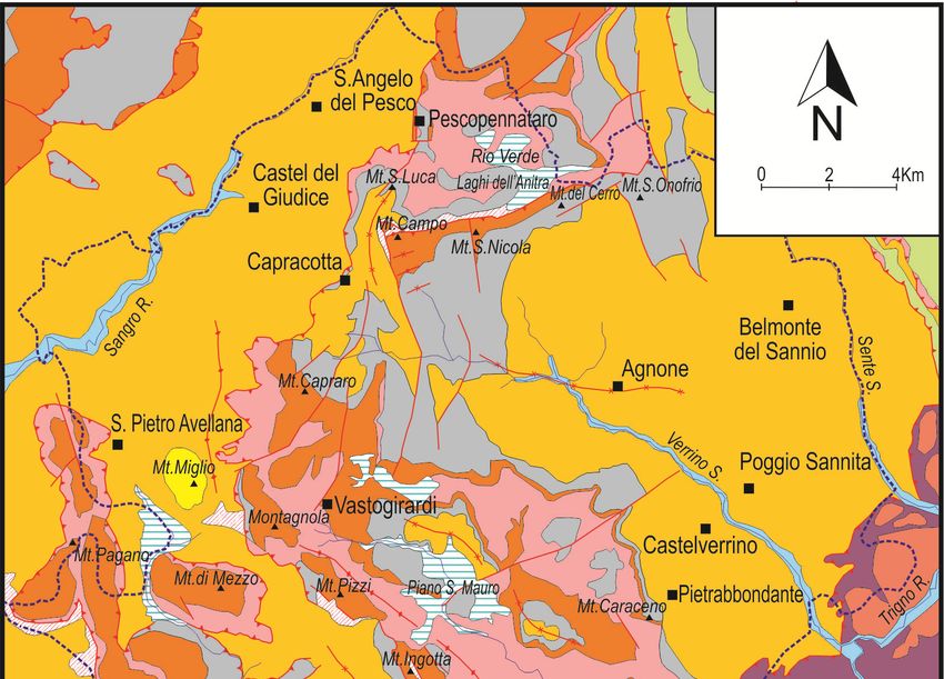
Resources 2020, 9, 31                                                                                                           6 of 20

      As a result of this complex geological and tectonic history, the Alto Molise landscape is strongly
dominated by structural landforms [20,57], especially monocline and anticline reliefs, often markedly
asymmetrical, such as those forming Mt. Miglio, La Montagnola, Mt. Pizzi and Mt. Ingotta (Figure 2),
typically aligned in the NW-SE direction. Slope processes and related landforms are widespread. Major
phenomena are large rock falls with related talus slopes affecting the steep structural carbonate slopes
(such as the one present along the western slope of Mt. Campo), together with complex landslides and
phenomena of accelerated water erosion in the surrounding hilly areas. Where the tectonic juxtaposition
of rigid carbonate rocks on plastic Miocene siliciclastic deposits has occurred, deep-seated gravitational
deformations, as those affecting Mt. Pizzi, are also documented [65]. Furthermore, karst landforms are
widespread where carbonate rocks crop out and are mainly represented by exokarst forms, such as
karren and dolines, but also by some endokarst landforms, such as the Vomero Resurgence (Table 1).
      From the bioclimatic point of view, the Alto Molise area is part of the temperate region [66],
characterized by marked differences in winter and summer temperatures, precipitations concentrated in
winter months, and summer aridity. Because of its climate conditions and geological-geomorphological
features, the Alto Molise area is characterized by a high richness in fauna and flora, and related
biodiversity. Its predominant forest vegetation is characterized by a high degree of naturalness [67],
indicating that the evolution of the forest ecosystems is controlled especially by natural processes and
only marginally influenced by human activities.
      The high naturalistic value of the Alto Molise area is strengthened by the presence of numerous
protected areas (Table 2) that occupy approximately 299.5 km2 , equal to 66% of its total surface area.
Among these, a special mention deserves the Collemeluccio-Montedimezzo Alto Molise Unesco Man
and Biosphere Reserve (Figure 1b), a large part of which falls in the Alto Molise territory.

                                       Table 2. The Alto Molise natural protected areas.

           Site Type                   Code and/or Name of Protected Natural Area                           Surface (km2 )
                                         Riserva Naturale Orientata Collemeluccio                                 4.22
             EUAP
                                         Riserva Naturale Orientata Montedimezzo                                  3.08
                                      Foresta Demaniale Regionale Bosco Pennataro                                 3.45
                                       Foresta Demaniale Regionale Monte Capraro                                  1.95
           non EUAP
                                Foresta Demaniale Regionale Bosco S. Martino e Cantalupo                          2.15
                                           Oasi Legambiente Selva Castiglione                                     3.00
                                                 IT7221132 Monte di Mezzo                                         3.13
              ZPS
                                              IT7221131 Bosco di Collemeluccio                                    5.00
                                         IT7218213 Isola della Fonte della Luna                                   8.67
                                              IT7218217 Bosco Vallazzuna                                          2.92
                                               IT7211120 Torrente Verrino                                         0.93
               SIC                   IT7212133 Torrente Tirino (Forra)–M. Ferrante                                1.45
                                 IT7218215 Abeti Soprani–M. Campo–M. Castelbarone–
                                                                                                                 30.33
                                                   Sorgenti del Verde
                          IT7212134 Bosco di Collemeluccio–Selvapiana–Castiglione–La Cocuzza                     62.39
                           IT7212124 Bosco di M. di Mezzo–M. Miglio–Pennataro–M. Capraro–
                                                                                                                 39.54
                                                    M. Cavallerizzo
              MaB              Collemeluccio-Montedimezzo Alto Molise Biosphere Reserve                         252.68 1
      1   The total surface of the MaB Reserve is indicated, including the portion that falls outside the Alto Molise macro-area.

     From the cultural point of view, the Alto Molise area offers various tourist attractions, first
some archaeological sites, such as the Temple-theater complex of Pietrabbondante and the Sanctuary
of Vastogirardi (Figure 1b). There are also several villages and small towns with nice historical
centres, like Agnone, famous for its craftmanship of bell casting, and Capracotta, well known for its
cross-country skiing area. Furthermore, this area hosts rich evidence of agro-pastoral traditions that
have contributed to the shaping of its cultural landscape, represented per excellence by the thòlos,
characteristic stone shelters used by shepherds, and the tratturi (Figure 1b), i.e., ancient pastoral
transhumance paths, also called drove roads [68]. Since the last decades, the tratturi have become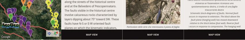
Resources 2020, 9, 31                                                                                  7 of 20

increasingly the subject of projects and studies [68,69] aimed at their recovery and fruition. Recently,
they have been included in the national catalogue of historical rural landscapes [70,71], while the
transhumance, the agropastoral practice of seasonal droving of livestock along migratory routes
(tratturi) in the Mediterranean and in the Alps (Austria, Greece and Italy), was entered in 2019 in the
representative list of the intangible cultural heritage of Humanity [72].

3. Materials and Methods

3.1. The Contents of the Application
     The central contents of the proposed mobile application, hereinafter also called MoGeo App or
simply App, are obviously the geosites and related geological itineraries.
     The selection of geosites to be included in the App was based on the criteria safety, accessibility,
scenic-aesthetic qualities, and interpretative potential that are in essence the selection criteria proposed
by Brilha [73] for the qualitative assessment of sites suitable for geotourism use. Based on the data
acquired during the Molise geosites inventory and other studies, the suitability of the 17 geosites was
assessed by attributing a value for each criterion using scores (1—low; 3—medium; 5—high).
     Safety and accessibility are considered indispensable criteria for geosite selection, to ensure their
safe and unconditioned access and tourist use. For areal geosites, the accessibility and safety of both
panoramic and on-site viewpoints were assessed.
     The scenic-aesthetic qualities of geosites, i.e., the visual appeal and the natural beauty of a site, as
well as the aesthetic qualities of the surrounding natural landscape, are considered of great importance
to attract people to geosites [23,74–76]. Moreover, they can facilitate the interpretation of geosites,
stimulate the curiosity of visitors and their desire to understand the geological-geomorphological
features of geosites as well as the processes that underlie their genesis and evolution.
     Despite the importance of aesthetics in tourism, according to Kirillova et al. [77], basic questions
of tourist aesthetic judgment are still under-explored. These authors provide an important contribution
to the understanding of “what makes a destination beautiful” by identifying and investigating nine
themes and related dimensions of tourist aesthetic judgment in the context of both nature-based
and urban tourist destinations. Another important aspect implicated in the aesthetic judgment is
highlighted by Mikhailenko et al. [78] who propose a simple aesthetic-based classification of geological
structures in outcrops based on their pattern, so as to take into account visions and attitudes of visitors
and help evaluating the attractiveness of geosites.
     To assess the scenic-aesthetic qualities of geosites, we have considered the following
indicators: shape, vegetation, naturalness/anthropic modifications, chromatic variety and contrasts,
and uniqueness. These indicators comprise some of the themes identified by Kirillova et al. [77],
especially the shape. The latter, in particular, is closely related to the landscape setting and geological
structure and includes the pattern sensu Mikhailenko et al. [78].
     The interpretative potential of geosites is considered essential for disseminating geological
information to non-geologists. It is closely related to the capacity of a geosite to be easily understood by
law people and, therefore, to its representativeness, i.e., to its capacity to illustrate geological elements
and processes.
     The choice of other contents (Figure 3) to be included in MoGeo App was guided by the idea of
enhancing and promoting not only geosites and related geo-itineraries, but also the overall naturalistic
and cultural contexts of the selected areas. This is also in the awareness that the connection between
natural and cultural heritage can represent a strength and a push factor for geotourism promotion,
by offering richer and more varied experiences to visitors, who are perhaps not experts in geology or
geology lovers, but simply families or lovers of landscape, nature and culture.
Resources 2020, 9, 31                                                                                                   8 of 20
Resources 2020, 9, 31                                                                                                11 of 22

                                        Figure 3. Flow
                                                  Flow Chart
                                                       Chart of the MoGeo App.

     Therefore, the contents included in MoGeo App consist of:
4. Results

 -    descriptive cards of selected geosites
4.1. Characteristics of Selected Geosites
 -    a glossary of scientific terms
 -    Fourteen
      geologicalofitineraries
                     the 17 Alto Molise geosites have been included in the App (Table 3), based on
scores obtained for selection criteria safety, accessibility, scenic-aesthetic qualities and interpretative
 -    a simplified geo-lithological sketch map
potential. Geosites D11, D16 and D17 (Table 1) were excluded due to their medium to low scores in
 -    Other sites of cultural and/or naturalistic interest
safety and accessibility: geosite D11 due to medium scores both in safety and accessibility, and
 -    the tratturi
geosites D16 and D17 (respectively a karst cave whose access is restricted to experts with caving
equipment    and
      To allow  thea use
                      landslide     area,to
                           of the App     see  Table
                                             both      1) due
                                                   Italian  andto     their low
                                                                   foreign         and all
                                                                             tourists,   medium
                                                                                            insertedscores
                                                                                                       titles respectively
                                                                                                               and texts havein
accessibility and   safety.
been written in two languages, Italian and English.
      The  14 selected
      For each  selected geosites
                            geosite, ahave    achieved
                                         descriptive   carda was
                                                              highprepared
                                                                       score inthatsafety  as they
                                                                                       contains        can be observed
                                                                                                  all essential  information in
complete    security     conditions,     with   nil   to   minimum        risk    for  visitors.
for understanding and for autonomously visiting the site. The inserted information was largely     Nine    geosites    can   be
appreciated
extracted fromby the
                  both    on-site
                       Molise       and panoramic
                                 geosites  inventoryviews        (Table 3),
                                                         data archive          threeand
                                                                           [49,58]    andother
                                                                                           two,studies
                                                                                                  instead,conducted
                                                                                                             only by on-site
                                                                                                                         about
and  panoramic    views,    respectively.
geosites/geotourism in the Alto Molise area [18,20,57].
      None    of contains,
      Each card   the selected        geosites
                              in addition  to thepresent
                                                   descriptionanyof use     limitation
                                                                      the geosite,         due toonaccess
                                                                                     information        the mainpermissions.
                                                                                                                   geoscience
Furthermore,    most of
interests. To select    thethe
                             mainselected  geosites
                                     geoscience        have obtained
                                                   interests   to insert ainhigh     score in
                                                                                the cards,   weaccessibility
                                                                                                 did not simply because   they
                                                                                                                      consider
do  not have   access   difficulties   and  are easily    reached     by paved     roads.  The   geosites
the major scientific interests of geosites (Figure 1c and Table 1), but geological themes that could be     Capo    di Vandra
spring
of widerand  Verrino
           and  perhaps  Stream     waterfalls interest.
                            environmental       (D1 and For  D14example,
                                                                    in Table we 3) are  characterized
                                                                                     considered            only by medium
                                                                                                   the geoscience      interest
scores in accessibility,
“Landscape   instability” because       the results
                             (see section   first site
                                                     andcan   only3),bewhich
                                                           Table         reached     by completing
                                                                                is closely linked to thetheissues
                                                                                                             last part   of the
                                                                                                                    of natural
route  by foot  or with    an  off-road   vehicle,   while   the   second    site, which   is located
hazard and risk and, in turn, to global issues such as the climate change. To ease the disclosure and    within   the  Verrino
Fluvial  Park, can
interpretation        only bethe
                of geosites,      reached   on foot.
                                     descriptive  cards Inwere
                                                            addition,
                                                                 enricheda medium       storeillustrative
                                                                             with specific     in accessibility    marks
                                                                                                            material        the
                                                                                                                       (photos,
geosite  Mt. Ingotta    anticline    (D10  in  Table   3)  as it  is necessary     to walk   a  path
sections, geological sketches, 3D schemes, etc.). Furthermore, to allow an optimal appreciation of eachon  foot  to  reach  the
on-site
geosite,view   for observing
         the best  on-site andinpanoramic
                                     detail the fossiliferous
                                                 viewpoints are    strata.
                                                                       indicated.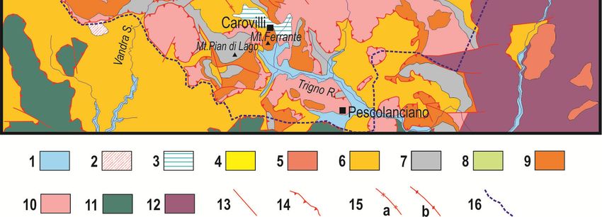
Resources 2020, 9, 31                                                                                                          9 of 20

      Table 3. List of selected geosites. ID, scores obtained for each criterion, type of proposed observation
      points, main geoscience interests, and other natural and cultural interests. H = Hydrogeology,
      Se = Selective erosion, L = Landscape instability, Pc = Paleoclimate; St = Stratigraphy,
      Sed = Sedimentology, T = Tectonics, Pe = Paleoenvironment, Pa = Paleontology.

           ID      S1      A2      SE 3    IP 4    O5       P6       MGI 7                     Other Interests
           D1       5       3       3       5       X                   H                  Flora, vegetation and fauna
           D2       5       5       5       5               X         Se–H        Flora, vegetation and fauna—Human history
           D3       5       5       5       3       X       X         Se–L                 Flora, vegetation and fauna
           D4       5       5       5       5               X         Se–Pc                Flora, vegetation and fauna
           D5       5       5       5       5       X                   H         Flora, vegetation and fauna—Human history
           D6       5       5       3       5       X                 Se–St       Flora, vegetation and fauna—Human history
                                                                                   Flora, vegetation and fauna—Agro-pastoral
           D7       5       5       5       5       X       X      Se–L–St–Sed
                                                                                                     tradition
          D8        5       5       3       5       X       X         St–Sed
          D9        5       5       5       3       X       X      Se–St–Sed–T
          D10       5       3       5       5       X       X       Se–Pe–Pa              Flora, vegetation and fauna
          D12       5       5       5       5       X       X       Se–St–Sed
          D13       5       5       5       5       X       X        Se–T–Pa
          D14       5       3       5       5       X       X           H               Flora, vegetation and fauna
          D15       5       5       3       5       X       X       Se–St–Sed     Human history, Architecture and Handicraft
      1   Safety; 2 Accessibility; 3 Scenic-aesthetic qualities; 4 Interpretative potential; 5 On-site view; 6 Panoramic view;
      7   Main geoscience interests.

     We tried to use the simplest language possible to be clear even for non-geologists. However, to
safeguard the scientific rigor, it was not possible to exclude certain scientific terms, so we included
among the contents a glossary of scientific terms.
     Considering that the use of geological itineraries and viewpoints is an important tool in geotourism
activities [23,79], we have created also some itineraries (four at the moment). These itineraries allow
the joint visit of different geosites and involve all selected geosites. Furthermore, to attract a large
audience, they follow the main road system. For each itinerary, we have detailed the path and the
sequence and location of stops. Based on logistic conditions and facilities (presence of parking areas,
rest areas, etc.), the best on-site and panoramic viewpoints were selected. For all stops, descriptive
cards were drawn up.
     Panoramic viewpoints become particularly important as they allow the observation of sites
represented by large landforms, which can be best appreciated from a distance. The importance of
panoramic viewpoints, especially where on-site views of geosites are not useful or available has led
to conceptualize a specific category of geosites: the viewpoint geosites [80,81]. According to these
authors, the location of panoramic viewpoints has to take into account not only the quality of the site
view they allow (clarity of features, good light, good visibility, etc.), but also the environmental context
surrounding the target, as well as the conditions and pattern of the standpoint.
     In the choice of our panoramic viewpoints, also some of the aforementioned criteria for viewpoint
geosites have been considered. So we selected standpoints that satisfy the following conditions:
easily accessible (normally located along the main road), not placed in private properties, with good
safety conditions, with null to minimum anthropogenic degradation, preferentially inserted in a
context characterized by few human interventions and a medium to high degree of naturalness,
not covered by dense vegetation, and allowing the view of geological/geomorphological features that
in many cases stand out (for color contrasts, vertical elevation, etc.) from the surrounding landscape.
Furthermore, where possible, we selected several panoramic points for the same geosite to allow the
specific observation of different/separate elements of the geosite. The preferential location of panoramic
viewpoints along main roads was also guided by the need to guarantee the mobile phone coverage.
     To best explain in the application the geosites from these panoramic views, we prepared panoramic
photos clearly visible at the screen size, partially “retouched” to better put in evidence the features to
be observed, and simplified sketches to illustrate the geological setting and the relief features.
     To sustain geological information given in the cards, we realized a geolithological sketch map
in the GIS environment, mainly based on the geological data extracted from the Geological Map of
Resources 2020, 9, 31 10 of 20
Molise in scale 1:100,000 [62]. Data on tectonics features, which may be excessively complex for an
audience of non-geologists, were not included in the map.
The other sites included in the App were selected by considering not only the best known cultural
and natural sites/areas of Alto Molise, but also lesser known sites, to give a comprehensive overview of
landscape, flora, vegetation and fauna, traditions, history, and archaeology of this territory. A simple
and concise information card was produced for each of these sites containing, where available, the link
to the official webpage of the site for further information.
Finally, the traces of the three tratturi that cross the Alto Molise territory were inserted in the App,
as they represent important and distinctive landscape elements. These traces were extracted from the
GIS project implemented during the Molise regional geosites inventory [49]. A general presentation of
this theme and a descriptive card for each tratturo were prepared.
3.2. The Implementation of the Application
To develop our App, we considered the following expected characteristics and
performance requirements:
- The application should be of easy and linear use. Contents should be accessible both by following
a drop-down menu and by starting from an interactive map;
- All sites and itinerary stops, as well as the position of the user, should be geolocalized on an
interactive map;
- The application should be usable on any kind of Android device, such as smartphones with
varying screen sizes and tablet computers;
- The application should be fast and should not require a high storage capacity of mobile devises;
- The application should be easily updatable and expandable, by adding features such as tools or
other data.
MoGeo App has been designed as a hybrid mobile app [45], a combination of web and native
mobile applications, in which the cartographic part interfaces directly with the host operating system (in
our case Android), while the information cards are inserted on a remote responsive website, optimized
for mobile. The web pages are loaded via WebView, a native component, and displayed on the device
as if they were themselves native. The advantage of this approach is to view the contents both from
MoGeo App and directly from the Web Browser by connecting to the specific website. Through the
geolocalization, it is possible to know the position both of the user and the single site, the distance
between them, and the shortest way to reach the site.
In detail, MoGeo App resides in two different virtual spaces:
- The cartographic part is developed through the Android Studio Software. This is a fully integrated
development system, created and made freely available by Google [82] for the development of
new applications. In particular, three different map types are used (Google street and satellite, and
geological maps) to localize the geo-touristic data related to different information cards (Figure 3).
- The other part includes the cards containing the information collected for all contents (Figure 3).
All information has been transcribed in HTML format by using a Content Management System
(CMS), called WordPress, and has been stored on an Italian Web Platform that AlterVista [83]
makes freely available for all users registered on this platform.
To avoid speed and performance reductions of the application, information cannot be stored on
the mobile devise, but is simply uploaded by using an Internet connection.
4. Results
4.1. Characteristics of Selected Geosites
Fourteen of the 17 Alto Molise geosites have been included in the App (Table 3), based on scores
obtained for selection criteria safety, accessibility, scenic-aesthetic qualities and interpretative potential.Resources 2020, 9, 31 11 of 20
Geosites D11, D16 and D17 (Table 1) were excluded due to their medium to low scores in safety and
accessibility: geosite D11 due to medium scores both in safety and accessibility, and geosites D16
and D17 (respectively a karst cave whose access is restricted to experts with caving equipment and a
landslide area, see Table 1) due to their low and medium scores respectively in accessibility and safety.
The 14 selected geosites have achieved a high score in safety as they can be observed in complete
security conditions, with nil to minimum risk for visitors. Nine geosites can be appreciated by
both on-site and panoramic views (Table 3), three and two, instead, only by on-site and panoramic
views, respectively.
None of the selected geosites present any use limitation due to access permissions. Furthermore,
most of the selected geosites have obtained a high score in accessibility because they do not have access
difficulties and are easily reached by paved roads. The geosites Capo di Vandra spring and Verrino
Stream waterfalls (D1 and D14 in Table 3) are characterized only by medium scores in accessibility,
because the first site can only be reached by completing the last part of the route by foot or with an
off-road vehicle, while the second site, which is located within the Verrino Fluvial Park, can only be
reached on foot. In addition, a medium store in accessibility marks the geosite Mt. Ingotta anticline
(D10 in Table 3) as it is necessary to walk a path on foot to reach the on-site view for observing in detail
the fossiliferous strata.
All selected geosites, except two, got a high score in interpretative potential, as they can be easily
understood by a large audience, in particular also by lay people without a geological background. The
two geosites with medium scores in interpretative potential (D3 and D9, Table 3) were anyway selected
because they are characterized by high scenic-aesthetic qualities.
Finally, most of the selected geosites have achieved a high score in scenic-aesthetic qualities, while
four of them (D1, D6, D8 and D15) reached a medium score, but were selected because of their high
interpretative potential.
The geoscience interests of selected geosites range between Hydrogeology and Landscape
instability (Table 3), with the latter being the most represented. Other interests of geosites are Flora,
vegetation and fauna, Agro-pastoral tradition, Human history, Architecture, and Handicraft (Table 3).
4.2. How to Access Information Using MoGeo App
MoGeo App, which is downloadable by using the link https://geositi.altervista.org/download or
the QR code in Figure 4, offers a simple and rapid way to reach information about contents included.
Once you open the Homepage (Step 1, Figure 4), information can be accessed through two separate
ways: the drop-down menu and the interactive map.
By staying on the Homepage, a drop-down menu can be opened that allows consulting the list of
contents (Step 2, Figure 4). By making a selection on one of these contents, for example geosites, the
user is redirected to the relative list of geosites (Step 3, Figure 4). By making a further selection on the
latter, it is possible to reach the page of the specific site. In addition, at the top of the map view there
are three buttons that allow respectively to return to the Homepage, to open the legend and to switch
to satellite mode.
Starting from the interactive map, information can be accessed through the sites/places of interest
that are localized on it by means of classic Google Maps textures and indicated with different colors
according to the type of content (Step 2, Figure 4). By clicking on one of them, a popup opens that
contains first information about the site, such as a photo and the name (Step 3, Figure 4). By clicking
on the latter, the user is redirected to the information card that contains the description and illustration
(text, photos, schemes, etc.) prepared for the specific site (Step 4, Figure 4).
4.3. Contents of MoGeo App
The content Geosites includes a general presentation and the information cards prepared for the
14 geosites. The presentation card (Figure 5) provides basic notions about the meaning of the term
geosite and a short information on the Alto Molise geosites. The information cards provide informationResources 2020, 9, 31 12 of 20
about the origin, geological-geomorphological features, and main geoscience interests of the geosite, as
Resources
well as about 2020,
the9, age
31 of rock formations involved. All cards are enriched with illustrations, 13especially
of 22
photos (Figure 5), geological sections and 3D schemes. The latter have been included mainly to explain
description and illustration (text, photos, schemes, etc.) prepared for the specific site (Step 4, Figure
some4).
specific geological features such as various types of faults (Figure 5).
Figure
Figure 4. The
4. The mainmain structure
structure of the
of the MoGeo
MoGeo App.
App. Step
Step 1: the
1: the Homepagethat
Homepage thataddresses
addressestotothe
thetwo
twotypes
types of data access; Step 2: the interactive map and the drop-down menu access; Step 3: the opening
of data access; Step 2: the interactive map and the drop-down menu access; Step 3: the opening of a
of a pop-up after clicking a site on the interactive map, and the opening of a specific list of sites by
pop-up after clicking a site on the interactive map, and the opening of a specific list of sites by selecting
selecting a single content from the drop-down menu; Step 4: the information card of a geosite. The
a single content from the drop-down menu; Step 4: the information card of a geosite. The figure
figure contains also the QR code to download the MoGeo App.
contains also the QR code to download the MoGeo App.
4.3. Contents of MoGeo App
The content Itineraries give access to the list of created geological itineraries (I1–I4, Table 4 and
Figure 6),The content Geosites includes a general presentation and the information cards prepared for
a card that provides a short information on each itinerary, and the descriptive cards that
the 14 geosites. The presentation card (Figure 5) provides basic notions about the meaning of the
illustrate each single stop. Two of these itineraries (I1 and I2) mainly develop in the northern sector
term geosite and a short information on the Alto Molise geosites. The information cards provide
of theinformation
Alto Molise area, the other two (I3 and I4) mainly in the southern sector. They are made of a
about the origin, geological-geomorphological features, and main geoscience interests
variable number
of the ofas
geosite, stops,
well from a minimum
as about the age ofofrock
5 (I2,formations
Table 4) toinvolved.
a maximum of 9 stops
All cards (I4, Table
are enriched 4), and
with
embrace several especially
illustrations, geoscience interests
photos (Table
(Figure 4) that allow
5), geological visitors
sections to deepen
and 3D schemes.certain geological
The latter have been topics.
Stopsincluded
are mostly verytoeasy
mainly to access,
explain as the itineraries
some specific run largely
geological features suchalong the main
as various typesroads. Walking
of faults (Figurepaths
5).
are needed only in some cases, precisely to reach the first stop of I2 itinerary, located within the Verrino
Fluvial Park, and the third and ninth stops of I4 itinerary (Table 4). Itineraries I1, I2 and I4 partly cross
protected natural areas (Table 4).Resources 2020, 9, 31 13 of 20
Resources 2020, 9, 31 14 of 22
Figure
Figure 5. Sequence
5. Sequence of screenshotsextracted
of screenshots extracted from
from MoGeo
MoGeoApp
Appthat illustrate
that various
illustrate aspects
various of theof the
aspects
content Geosites.
content Geosites.
The content Itineraries
Table 4.give access
Main to the list of
characteristics of created
the created geological itineraries (I1–I4, Table 4 and
four itineraries.
Figure 6), a card that provides a short information on each itinerary, and the descriptive cards that
Itinerary Stop Geosite O1 P2 Geoscience Interests Route Natural Areas
illustrate each single stop. Two of these itineraries (I1 and I2) mainly develop in the northern sector
1 D7 X
of the Selective erosion
I1 Alto Molise
2 area, D7
the other two (I3 and X I4) mainly in the southern sector. They are made of a
Tectonics
Capracotta- 3 of stops,D7 from a minimum
X Xof 5 (I2, Table 4) to a maximum Main
variable
Rio Verde
number Landscape instability of 9 stops (I4, Table
IT7218215 SIC 4),
4 D6 X roads
Paleoenvironment
and embrace several
Springs 5 geoscience
D13 interests
X (Table 4) thatHydrogeology
allow visitors to deepen certain geological
6
topics. Stops are mostlyD5very easy X
to access, as the itineraries run largely along the main roads.
1 D14 X Selective erosion
Walking
I2 paths 2
are neededD7
only in some
X
cases, precisely to reach
Landscape the first stop
instability Path
of I2 itinerary, located
within the Verrino
Capracotta- 3 Fluvial
D7 Park, and the thirdX and ninth stops of I4 itinerary
Hydrogeology Main(Table 4).Verrino
Itineraries I1,
Fluvial Park
Agnone 4 D7 X Stratigraphy roads
I2 and I4 partly5 cross protected
D15 natural
X areas (Table 4). Sedimentology
1 D9 X
2 D9 X
I3
3 D8 X Stratigraphy Main
Pietrabbondante-
4 D12 X Sedimentology roads
Agnone
5 D15 X
6 D15 X
D10 X
1
D3 X
2 D10 X
Selective erosion
3 D10 X
I4 Landscape instability Main MAB Reserve
Carovilli- 4 D3 X Paleoclimate roads Collemeluccio-Montedimezzo
Capo di Vandra 5 D3 X Paleoenvironment Paths Alto Molise
6 D2 X Hydrogeology
7 D2 X
8 D4 X
9 D1 X
1 On-site view; 2 Panoramic view.
Regarding the content Other sites (Figure 7), we have included for now nine sites, three of
naturalistic and six of cultural interest (Figure 1), which are well distributed throughout the Alto
Molise territory. The sites of naturalistic interest are the Garden of Apennine flora of Capracotta,
the Collemeluccio–Montedimezzo Alto Molise MaB Reserve and the Verrino Fluvial Park. The sites of
cultural interest are the Samnite Temple of Vastogirardi, the Temple-theater complex of Pietrabbondante,
the Bell Museum of Agnone, the Stone Museum of Pescopennataro, the Castel of Pescolanciano, and
the Museum of Transhumance of Agnone. Information cards illustrate with a synthetic text and some
photos major features of each site (Figure 7).
Regarding the content Tratturi, all three major drove roads that cross the Alto Molise territory,
the tratturi Ateleta–Biferno, Castel di Sangro–Lucera and Celano–Foggia (Figure 7), were included in
our App. The traces of the first are visible in the northern sector of the Alto Molise area, while the
traces of the other two are preserved in the southern sector. Also for the tratturi, in addition to theD10 X
1
D3 X
2 D10 X
Selective erosion
3 D10 X Main MAB Reserve
I4 Landscape instability
4 D3 X roads Collemeluccio-
Carovilli-
Resources 2020, 9, 31 Paleoclimate 14 of 20
5 D3 X Montedimezzo
Capo di Vandra Paleoenvironment
6 D2 X Paths Alto Molise
Hydrogeology
7 D2 X
singleResources
information
2020, 9, 31cards (Figure 7), a general presentation card was compiled. This card 16 contains
of 22
8 D4 X
information on the transhumance and related paths, i.e., the tratturi, and allows to have an overview
9
Regarding the content D1 sitesX (Figure 7), we have included for now nine sites, three of
Other
about this ancient agro-pastoral practice and all major tratturi that cross the Molise territory.
1 On-site
naturalistic and six of cultural interest 2 view; 1),
(Figure Panoramic view.
which are well distributed throughout the Alto
Molise territory. The sites of naturalistic interest are the Garden of Apennine flora of Capracotta, the
Collemeluccio–Montedimezzo Alto Molise MaB Reserve and the Verrino Fluvial Park. The sites of
cultural interest are the Samnite Temple of Vastogirardi, the Temple-theater complex of
Pietrabbondante, the Bell Museum of Agnone, the Stone Museum of Pescopennataro, the Castel of
Pescolanciano, and the Museum of Transhumance of Agnone. Information cards illustrate with a
synthetic text and some photos major features of each site (Figure 7).
Regarding the content Tratturi, all three major drove roads that cross the Alto Molise territory,
the tratturi Ateleta–Biferno, Castel di Sangro–Lucera and Celano–Foggia (Figure 7), were included
in our App. The traces of the first are visible in the northern sector of the Alto Molise area, while the
traces of the other two are preserved in the southern sector. Also for the tratturi, in addition to the
single information cards (Figure 7), a general presentation card was compiled. This card contains
information on the transhumance and related paths, i.e., the tratturi, and allows to have an overview
about this ancient agro-pastoral practice and all major tratturi that cross the Molise territory.
Two further products were included in MoGeo App: A geolithological map and a glossary of
scientific terms. The geolithological map (Figure 7) allows visualizing each site in its specific
geological context, contributing to a better understanding of the geological information provided by
the cards. The glossary of scientific terms, instead, can help not only to better understand
information
Figure 6. provided
Sequence byscreenshots
of cards for geosites,
extractedbut
fromalso representsthat
MoGeo a useful toolvarious
for tourists who wish to
Figure 6. Sequence of screenshots extracted from MoGeoAppApp that illustrate
illustrate aspects
various of the
aspects of the
deepen their knowledge
content Itineraries. about geological elements/topics. It allows easy research on specific
content Itineraries.
scientific terms included in the information cards.
FigureFigure 7. Sequence
7. Sequence of screenshots
of screenshots extracted
extracted from
from MoGeoApp
MoGeo Appthat
thatillustrate
illustrate various
various aspects
aspectsrelated
related to
to contents Other sites, Tratturi and Geo-lithological map.
contents Other sites, Tratturi and Geo-lithological map.
5. Discussion and Conclusions
Two further products were included in MoGeo App: A geolithological map and a glossary of
MoGeoThe
scientific terms. App represents a smart
geolithological maptool that 7)
(Figure allows thevisualizing
allows access to specific geotouristic
each site information
in its specific geological
context, contributing to a better understanding of the geological information providedmaps
about sites/places of geological, natural and cultural interest geolocalized on Google earth and
by the cards.
satellite views, by using a small mobile device, such as a smartphone.
The glossary of scientific terms, instead, can help not only to better understand information provided
It offers a simple and rapid way to reach information and, thanks to its hybrid nature, can be
by cards for geosites, but also represents a useful tool for tourists who wish to deepen their knowledge
defined as a user-friendly tool, because of the velocity with which it elaborates the commands of the
about geological elements/topics. It allows easy research on specific scientific terms included in the
user and the accuracy of its geolocation functionality. In fact, this App has been developed
information cards.
considering that not all users have sophisticated and high-performing mobile devises and/or high
knowledge and manual skills in using their smartphone. Obviously, some difficulty or limitation
can arise from the diversity of mobile devices and related graphic performance capabilities.Resources 2020, 9, 31 15 of 20
5. Discussion and Conclusions
MoGeo App represents a smart tool that allows the access to specific geotouristic information
about sites/places of geological, natural and cultural interest geolocalized on Google earth maps and
satellite views, by using a small mobile device, such as a smartphone.
It offers a simple and rapid way to reach information and, thanks to its hybrid nature, can be
defined as a user-friendly tool, because of the velocity with which it elaborates the commands of the
user and the accuracy of its geolocation functionality. In fact, this App has been developed considering
that not all users have sophisticated and high-performing mobile devises and/or high knowledge and
manual skills in using their smartphone. Obviously, some difficulty or limitation can arise from the
diversity of mobile devices and related graphic performance capabilities.
In addition, MoGeo App is based on an archive of information that can be updated, modified
and enriched with new information and cartographic tools. In this case, the only limitation of the
information that can be accessed is related to the computing power of the device.
The developed application is suitable for guiding individual visits (perhaps even involving only
single sites) and tours that are selected among the offered itineraries or developed by users according
to their specific geo-naturalistic and cultural interests and time available. Therefore, it is able to meet
the needs and preferences of a large audience, including families as well as hikers, amateur geologists
and admirers of natural beauty, encouraging them to visit these places often forgotten by the media.
Besides its use during visits/excursions, MoGeo App can also be useful for analyzing preventively
the areas of interest, especially for defining the best road connections and acquiring information about
the geographical and geological contexts that characterize the area and the individual sites that can be
visited. In Italy, there are some examples of applications created for geotourism purposes in other
regional areas (e.g., [84,85]). By comparing MoGeo App with other applications, it is possible to observe
some differences. One of the main differences is that MoGeo allows to process together different
types of information, organized in separate categories, not just geosite information. In fact, great
importance assumes the possibility of accessing with a single application different contents (geological,
natural, cultural, etc.) that can be geolocated on interactive maps, by using mapping service portals
such as Google Maps. Also the drop-down menu appears extremely useful, as it allows to reach the
different contents without using the map. In this way, the individual user can choose the way to receive
information according to his needs.
Other strengths of this application are its light and smart structure. In particular, the information
is acquired directly remotely without downloading data to the smartphone. This allows to avoid speed
and performance reductions of the application.
However, MoGeo App also has some limitations. Being developed for smartphones/tablets, due to
the reduced size of the screens, the scale of images cannot be of elevated detail and resolution. Another
limitation is that, for now, MoGeo does not include the use of Augmented Reality (AR), which could
be developed in the future.
To create our application, we chose to use only the Android operating system, because it is the
most widespread in Europe and in Italy (in December 2019, 81.4% of Italian smartphone users are
Android [86]) and provides for free both the possibility to publish the application on its store and to
use the API (Application Programming Interface) to connect to the tools of Google Maps. However, in
the future we would like to create a version for IOS, so as to reach all smartphone users.
During the phase of design, MoGeo App has been tested remotely and directly in the field on
a group of a dozen people without geological background to get a first quick feedback on the ease
of use and efficiency of the application, as well as on the curiosity towards and liking of proposed
contents. By questioning the group used as for the test, it was possible to verify a large appreciation of
contents and a positive judgment about the lightness of the application (~3 Mb), which allows a quick
download on the mobile phone, even on less technologically advanced smartphones. Furthermore,
the logic and structure of the application resulted in being intuitive for everyone. In particular, no one
had difficulties in finding information both on the geosites and the territory in general, managing toYou can also read