Monitoring Landscape Change 2003 2021 - 2nd Edition 2021 - Derbyshire ...
←
→
Page content transcription
If your browser does not render page correctly, please read the page content below
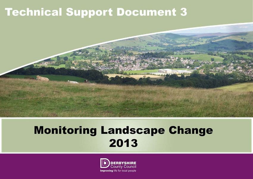
2nd Edition 2021

              Monitoring Landscape Change
                      2003 - 2021
Introduction
This Technical Support Document is intended to support Part 5 of ‘The
Landscape Character of Derbyshire’ publication. Part 5 aims to underpin the
objectives of the European Landscape Convention (ELC) by monitoring
landscape change and helping involve people in understanding this change
(Articles 5, 6A-D).

At the national level, attempts to monitor landscape change have been
delivered through initiatives such as Countryside Quality Counts (CQC), which
looks at landscape change in the context of National Character Areas. Using
various national datasets this review monitors landscape change in the context
of four potential outcomes:
        •    Maintained – stable and consistent with character/vision
        •    Enhancing – changing and consistent with character/vision
        •    Neglected – stable but inconsistent with character/vision
        •    Diverging – changing but inconsistent with character/vision
The CQC project recommends that landscape change should be monitored on
a 5 year cycle. The scale of the CQC approach is not particularly relevant at
the county scale, so in this context it is proposed to monitor landscape change
in Derbyshire through the use of fixed point photography on a 5 yearly cycle.

Method
The fixed point photography has identified 24 viewpoints across the county.
Some of these viewpoints are the same as were chosen in the first edition of
‘The Landscape Character of Derbyshire’ document and, as such, allow for the
monitoring of landscape change since it was published. Others are new
locations often taken from elevated vantage points that allow for broad
panoramic views over large areas. These views may reflect a number of
landscape character types and are often selected in anticipation of known
pressures for change.

Photos used in the original publication were taken during 2003 with the
subsequent photos taken in 2011 and 2016. The most recent photos have
been taken during the spring and summer of 2021. Where a photograph is
taken from the position of one of the original photographs, the latest photo is
shown side by side to demonstrate the changes that have taken place in the
intervening period. Additional photos taken between the first and latest images
are also included at each location for comparison and completeness.
It is proposed that the exercise will be repeated every 5 years to monitor
landscape change to provide feedback for the planning process and help
inform future training requirements.

                                                                              2
HADFIELD & GLOSSOP FROM CHARLESWORTH ROAD (MONKS ROAD)

                                                                                                                                                              2011

                                                                                                                                                              2021

                                                           A settled, pastoral farming landscape on gently sloping lower valley sides, dissected by stream valleys.
                               Settled Valley
  DARK PEAK                                                Dense watercourse trees, scattered boundary trees and tree groups around settlement contribute to a
                                 Pastures                  strongly wooded character.

A panoramic view of Hadfield, Simmondly and Glossop from Charlesworth Road near Coombes Edge.   Direction: North   Grid Ref: 4022 3923

Landscape Character: This is a view of the Settled Valley Pastures in the Dark Peak taken from an elevated vantage
point within the Peak District National Park. This is a well settled, pastoral landscape with a well wooded character.

Baseline landmarks and visual features:
Foreground – Simmondley (left centre) and heather moorland and birch scrub on Herod Edge (far right).
Middle distance – Gamesley estate set within woodland (far left), viaduct at Dinting Vale, Mouselow Quarry (middle) and
western edge of Glossop (right).
Background – distant views towards Hollingworth, Hadfield and Tintwistle with Arnfield reservoir just visible (centre left).

Change to view: 2011 to 2021 - there has been some restoration to the far slopes of Mouselow Quarry. The new
Glossopdale School can be seen beyond the viaduct (now painted green), new allotments to the right and some modest
infill development along Dinting Road. There is little discernible difference so the overall character of the landscape in
the view is assessed as Maintained.
                                                                                                3
HADFIELD & GLOSSOP FROM CHARLESWORTH ROAD (MONKS ROAD)

Additional Photographs

                                                                      2016

                                       4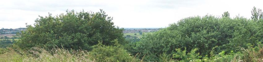
CHAPEL-EN-LE-FRITH FROM COWLOW LANE, WEST OF DOVE HOLES

                                                                                                                                                                 2011

                                                                                                                                                                 2021

                                                              A settled, pastoral farming landscape on gently sloping lower valley sides, dissected by stream valleys.
                                Settled Valley
  DARK PEAK                                                   Dense watercourse trees, scattered boundary trees and tree groups around settlement contribute to a
                                  Pastures                    strongly wooded character.

A panoramic view from near Bank Hall Farm, Cowlow Lane looking over Chapel-en-le-Frith.   Direction: North   Grid Ref: 4051 3786

Landscape Character: An elevated vantage point from the edge of the Moorland Fringe (Dark Peak) looking over the
Settled Valley Pastures near Chapel-en-le-Frith towards the distant hills of the Peak District National Park.

Baseline landmarks and visual features:
Foreground – rough grazing associated with the Moorland Fringe.
Middle distance – the settlement of Chapel dominates the centre of the view with the new secondary school visible
immediately left of the railway line. Directly left of the school is the area known as Lower Crossings.
Background – the distant hills of the Peak District form the skyline with Chinley Churn being the hill summit to the left of
the view.

Change to view: 2011 to 2021 - there has been some residential expansion to the left and adjacent to the railway line in
the middle of the view. This change does not impact on the settlement pattern so overall the character of the landscape
in the view is assessed as Maintained.
                                                                                          5
CHAPEL-EN-LE-FRITH FROM COWLOW LANE WEST OF DOVE HOLES

Additional Photographs

                                                                       2016

                                        6
DARLEY DALE AND THE DERWENT VALLEY FROM STANTON MOOR

                                                                                                                                                                     2011

                                                                                                                                                                     2021

                                   Riverside                  Gentle valley floors contain upland rivers, lined with dense trees. Hedgerows enclose small, sub-regular
  DARK PEAK                                                   fields in a pastoral landscape, interrupted by the occasional historic mill.
                                   Meadows

A panoramic view of the Derwent Valley at Darley Dale towards Matlock from Stanton Moor.   Direction: East    Grid Ref: 4250 3629

Landscape Character: An elevated vantage point from Stanton Moor looking over the Derwent Valley comprising the
Settled Valley Pastures, Riverside Meadows and more distant Enclosed Moorland. This view shows the contrast be-
tween the Riverside Meadows and the Settled Valley Pastures.
Baseline landmarks and visual features:
Foreground – tops of trees flanking the steep slopes rising to Stanton Moor and the extensive poplar plantations around
the Enthovens factory (far right). Middle distance – the main residential area of Darley Dale centred on Broadwalk and
the Parkway (left of centre) with the open floodplain in front and interlocking woodland to the rear. The edge of Matlock is
visible along the valley in the distance (far right). Background – the plantation woodlands on Darley and Matlock moors
form the skyline.
Change to view: 2011 to 2021 - there has been some modest development to the left of the view (industrial to residen-
tial) and along the valley towards Matlock including the extension of the Old Road Industrial Estate (centre right). Whilst
locally these developments have had some impact overall the view remains largely unchanged and the overall character
of the landscape in the view is assessed as Maintained.
                                                                                           7
DARLEY DALE AND THE DERWENT VALLEY FROM STANTON MOOR

Additional Photographs

                                                                      2016

                                        8
HARPUR HILL BUSINESS PARK FROM SOLOMON’S TEMPLE

                                                                                                                                               2011

                                                                                                                                               2021

                            Upland Limestone                 An undulating highland landscape of rough grazing and stock rearing, with prominent limestone outcrops
 WHITE PEAK                                                  and open, expansive views.
                                Pastures

A panoramic view of Harpur Hill Business Park from Solomon’s Temple.                     Direction: South   Grid Ref: 4054 3717

Landscape Character: An elevated vantage point of the Upland Limestone Pastures in the White Peak; undulating
upland with steep slopes, bare rock outcrops, rough grazing and essentially treeless. The landscape character is now
impacted upon by quarrying and the Harpur Hill Business Park.

Baseline landmarks and visual features:
Foreground – rough grazing and rocky outcrops of Grin Low.
Middle distance – dominated by the Harpur Hill Business Park including the Health and Safety Laboratory.
Background – The skyline is formed by Hoffman Quarry (now disused – left), Staker Hill, Chrome Hill (pointed hill summit
in the centre) and the distant hills of the South West Peak (far right).

Change to view: 2011 to 2021 - there has been expansion of the business park (left and centre of view) and recent tree
planting to the right of the HSE building has become established. These changes are inconsistent with the character of
the Upland Limestone Pastures so overall the view is assessed as Diverging.
                                                                                         9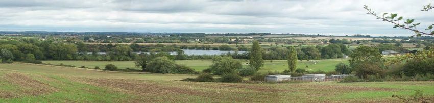
HARPUR HILL BUSINESS PARK FROM SOLOMON’S TEMPLE

Additional Photographs

                                                                     2016

                                         10
VIA GELIA WOODLANDS FROM MASSON HILL
2013 2021
Narrow, deeply incised river valleys with steep slopes and extensive amounts of exposed rock. There are
WHITE PEAK Limestone Dales blocks of ancient woodland, areas of scrub and rough grassland grazed by sheep.
A single frame view taken on footpath off Ember Lane looking towards Griffe Grange Direction: South-West Grid Ref: 4283 3582
Landscape Character: An elevated view from Masson Hill looking across the wooded Limestone Dales of the Via Gellia
to the Plateau Pastures beyond.
Baseline landmarks and visual features:
Foreground – small pastoral fields with some medieval lynchets bounded by dry-stone walls with uncharacteristically
dense mature boundary trees.
Middle distance – heavily wooded limestone dale including large areas of ancient woodland
Background – Pastoral fields of the plateau pastures at Middleton Moor to the left and Harboro’ Rocks to the right.
Change to view: 2013 to 2021 - three additional wind turbines are evident on the skyline adding to the four turbines
erected at Carsington Pastures (although the Carsington turbines are not evident on the 2013 photo). In all other
respects there is no discernible difference in the view so overall the character of the landscape in the view is assessed
as Maintained.
11VIA GELIA WOODLANDS FROM MASSON HILL
Additional Photographs
2016
12ALPORT HEIGHTS FROM BULLHILL FARM, SOUTH OF KIRK IRETON
2011 2021
DERBYSHIRE PEAK
Wooded Slopes This is a landscape of small pastoral fields on undulating, rising ground. Woodland on steeper
FRINGE AND LOWER slopes, along with hedgerow and watercourse trees contribute to a strongly wooded character.
and Valleys
DERWENT
A single frame view taken from Bullhill (farm) to the south of Kirk Ireton looking towards Alport Heights. Direction: East Grid Ref: 4271 3493
Landscape Character: This is predominantly a view of the Wooded Slopes and Valleys in the Peak Fringe; undulating
topography, small pastoral fields and well wooded. The lower lying land in the middle distance shows the Wooded
Farmlands with the hill summit at Alport Heights being in the Gritstone Moors & Heath.
Baseline landmarks and visual features:
Foreground – pastoral fields near Bulhill Farm.
Middle distance – scattered farmsteads that comprise the community of Ashleyhay.
Background – telecommunication masts at Alport Heights form the skyline.
Change to view: 2011 to 2021 - minor variation in colour of grassland due to slight difference in timing of photos but
otherwise no discernible difference in the view. Overall the character of the landscapes in this view is assessed as
Maintained.
13ALPORT HEIGHTS FROM BULLHILL FARM, SOUTH OF KIRK IRETON
Additional Photographs
2016
14LOOKING SOUTH-EAST FROM MILL LANE BETWEEN BRADBOURNE AND BRASSINGTON
2011
2021
DERBYSHIRE PEAK A gently undulating to rolling pastoral landscape over mixed geology, characterised by densely
FRINGE AND LOWER Settled Farmlands scattered hedgerow trees and along watercourses. Villages and sparsely scattered farmsteads give
DERWENT the impression of a well-settled landscape.
A panoramic view from Mill Lane between Bradbourne and Brassington. Direction: South-East Grid Ref: 4218 3538
Landscape Character: An elevated vantage point on the edge of the Limestone Slopes in the White Peak looking
across the Settled Farmlands within the Peak Fringe. This is a typical view of the gently undulating landform, small to
medium fields enclosed by hedgerows and occasional walls, permanent pasture with extensive ridge and furrow, and
densely scattered hedgerow trees.
Baseline landmarks and visual features:
Foreground – pastoral fields with extensive ridge and furrow immediately adjacent to Mill Lane, near Bradbourne.
Middle distance – small pastoral fields with dense hedgerow trees on minor ridgeline to the west of Carsington Reservoir
with the open rising ground of Carsington Pastures to the far left.
Background – glimpsed views beyond ridgeline to more elevated parts of Peak Fringe.
Change to view: 2011 to 2021 - there is some deterioration of the dry stone wall in the foreground, some agricultural
neglect and variation in the colour of the grassland due to the slight difference in the timing of the photos but otherwise
there is little change in the view. Overall the character of the landscape in this view is assessed as Maintained.
15LOOKING SOUTH-EAST FROM MILL LANE BETWEEN BRADBOURNE AND BRASSINGTON
Additional Photographs
2016
16DRONFIELD VALLEY FROM APPERKNOWLE
2011
2021
NOTTINGHAMSHIRE,
Wooded Hills A broadly undulating upland with a strongly wooded character, defined by woodland, mixed
DERBYSHIRE & YORKSHIRE farming and sparsely scattered settlement.
and Valleys
COALFIED
Panoramic view from an elevated vantage point on Summerley Road, Apperknowle Direction: South-West Grid Ref: 4379 3785
Landscape Character: A typical view of the Wooded Slopes and Valleys in the Derbyshire Coalfield; mixed farming,
hedgerow boundaries, extensive woodland and tree cover, and scattered hamlets and farmsteads
Baseline landmarks and visual features:
Foreground - properties along Summerley Lower Road.
Middle distance – Ramshaw Wood wrapping around plateau edge (left), Drone Valley extending away towards
Chesterfield (left centre), the Hallowes residential area of Dronfield (right).
Background – Northern suburbs of Chesterfield (Sheepbridge/Dunston) and the hills of the Peak Fringe on the far
horizon.
Change to view: 2011 to 2021 - other than the temporary taped fencing in the foreground, the developing woodland to
the rear of the white property and the variation in grassland colour, the view remains largely unchanged. Overall the
character of the landscape in this view is assessed as Maintained.
17DRONFIELD VALLEY FROM APPERKNOWLE
Additional Photographs
2016
18FORMER STAVELEY WORKS FROM MIDDLECROFT, STAVELEY
2011
2021
NOTTINGHAMSHIRE,
Estate
DERBYSHIRE & YORKSHIRE A broad, gently undulating landscape characterised by mixed farming and sparse tree cover.
Farmlands
COALFIED
A panoramic view towards the former Staveley Works site, Hall Lane landfill site and Barrow Hill. Direction: North Grid Ref: 4424 3741
Landscape Character: An elevated vantage point (St John’s Street, Middlecroft) within the Estate Farmlands
(Derbyshire Coalfield) looking across the Riverside Meadow of the River Rother to Estate Farmlands beyond. The
distant hills to the left comprise the Wooded Hills and Valleys.
Baseline landmarks and visual features:
Foreground – arable fields of the Estate Farmlands.
Middle distance – the floodplain of the River Rother with the river defined by the linear tree belt immediately behind the
pylons. Beyond the river is the scrubby ground of the former Staveley Ironworks with the current chemical works evident
to the right. The settlement of Barrow Hill is visible to the left centre with the gently domed landform of the Hall Lane
landfill site to the right.
Background – the skyline is formed by the rising ground and extensive woodlands of the Wooded Hills and Valleys.
Change to view: 2011 to 2021 - there has been significant woodland regeneration on the Staveley Works and Hall Lane
Tip sites and further demolition of the Staveley Chemical Works (right). These changes deliver some improvements so
overall the character of the landscape in the view is assessed as Maintained/Enhancing.
19FORMER STAVELEY WORKS FROM MIDDLECROFT, STAVELEY
Additional Photographs
2016
20LOOKING NORTH FROM SUTTON SCARSDALE HALL
2011
2021
NOTTINGHAMSHIRE,
Estate
DERBYSHIRE & YORKSHIRE A broad, gently undulating landscape characterised by mixed farming and sparse tree cover.
Farmlands
COALFIED
A panoramic view from Sutton Scarsdale Hall. Direction: North Grid Ref: 4442 3689
Landscape Character: A typical view of the Estate Farmlands in the Derbyshire Coalfield; broadly undulating
topography, mixed farming dominated by arable, hedgerows, localised woodlands and occasional trees, an open
landscape with long distance views.
Baseline landmarks and visual features:
Foreground – large arable field within the former park boundary to Sutton Scarsdale Hall.
Middle distance – dominated by the newly restored landscape of the former Arkwright opencast coal site. The degraded
land surrounded by trees (left centre) is the location of the former site office/compound to the opencast coal site.
Background – distant views beyond Arkwright Town and Duckmanton towards the northern coalfield and the rising
ground of the Southern Magnesian Limestone plateau (far right).
Change to view: 2011 to 2021 - three solar farms are now evident (left, centre and right) and a single large wind
turbine. A new waste recycling facility is visible on the former Arkwright tip site. Woodlands and hedgerows planted on
the former Arkwright Surface Mining site continue to develop and mature. Despite recent developments the overall
character of the landscape in the view is assessed as Maintained.
21LOOKING NORTH FROM SUTTON SCARSDALE HALL
Additional Photographs
2016
22LOOKING WEST FROM PALTERTON
2011
2021
NOTTINGHAMSHIRE,
Estate
DERBYSHIRE & YORKSHIRE A broad, gently undulating landscape characterised by mixed farming and sparse tree cover.
Farmlands
COALFIED
A panoramic view across the northern Derbyshire Coalfield from Palterton. Direction: West Grid Ref: 4474 3684
Landscape Character: An elevated vantage from the western edge of the Limestone Farmlands in the Southern
Magnesian Limestone looking across the Wooded Farmlands, Riverside Meadows to the Estate Farmlands of the
Derbyshire Coalfield.
Baseline landmarks and visual features:
Foreground – lower slopes of the Wooded Farmlands dominated by arable cropping. Middle distance – the tree-lined
corridor of the Riverside Meadows defining the route of the River Doe Lea located immediately at the foot of the scarp
slope. Deepdale Farm is in the centre beyond the river corridor and Sutton Scarsdale Hall is located further beyond at
the edge of woodland, both within the Estate Farmlands. Background – the skyline is defined by the distant hills of the
Peak Fringe.
Change to view: 2011 to 2021 - other than some solar farm development in the middle distance to the right of Sutton
Scarsdale Hall and variation in land use, there is no discernible difference in the view. Overall character of the landscape
in the view is assessed as Maintained.
23LOOKING WEST FROM PALTERTON
Additional Photographs
2016
24MARKHAM VALE FROM SHUTTLEWOOD ROAD, BOLSOVER
2011
2021
NOTTINGHAMSHIRE,
Wooded A small scale undulating landscape rising to the magnesian limestone plateau. Characteristically
DERBYSHIRE & YORKSHIRE well-wooded, sparsely settled and dominated by mixed farming.
Farmlands
COALFIED
A panoramic view from an elevated position towards Markham Vale and Duckmanton. Direction: West Grid Ref: 4471 3710
Landscape Character: An elevated vantage point in the Wooded Farmlands (Derbyshire Coalfield) looking across the
wider Estate Farmlands. This is not a typical view of either with much of the foreground and middle distance dominated
by degraded or recently restored land associated with the former Coalite works, and Bolsover and Markham Collieries.
Baseline landmarks and visual features:
Foreground – beyond the rooftops of Bolsover is the recently planted former Bolsover North colliery tip with Woodhouse
Lane running over the top. Middle distance – former Coalite Works to the left of the Bolsover north tip with the wooded
former Markham Colliery tip immediately to the right. Background – long distance views towards Brimington and
Staveley with the hills of the Peak District forming the far horizon.
Change to view: 2011 to 2021 - new industrial development at Markham Vale dominates the middle distance with the
new wind turbine and solar farm beyond. The restored Bolsover Colliery Tip continues to mature creating a large
woodland block. Although the new woodlands help to assimilate new development, overall the impact of the Markham
Vale Growth Zone is significant and inconsistent with the vision for the respective LCTs so overall the character of the
landscape in the view is assessed as Diverging.
25MARKHAM VALE FROM SHUTTLEWOOD ROAD, BOLSOVER
Additional Photographs
2016
26LOOKING NORTH-EAST FROM M1 NEAR SUTTON SCARSDALE HALL
2011
2021
NOTTINGHAMSHIRE,
Wooded A small scale undulating landscape rising to the magnesian limestone plateau. Characteristically
DERBYSHIRE & YORKSHIRE well-wooded, sparsely settled and dominated by mixed farming.
Farmlands
COALFIED
A panoramic view looking generally east from the M1 near Sutton Scarsdale Hall. Direction: North-East Grid Ref: 4452 3690
Landscape Character: A vantage point from Carr Lane near the M1 motorway, from the footpath to Lodge Farm, within
the Derbyshire Coalfield Estate Farmlands looking to monitor change to the Wooded Farmland on the scarp slope. The
foot of the scarp slope defines a narrow corridor for the River Doe Lea which is part of the Riverside Meadows.
Baseline landmarks and Visual Features:
Foreground – arable fields immediately east and north-east of Sutton Scarsdale Hall.
Middle Distance - linear tree belt associated with River Doe Lea and Stockley Trail.
Background – the scarp slope immediately south of Bolsover and west of Palterton.
Change to view: 2011 to 2021 - there has been some modest tree and hedgerow loss on the slopes below Palterton
and there is minor variation in agricultural land use. Overall the character of the landscape in the view is assessed as
Maintained.
27LOOKING NORTH-EAST FROM M1 NEAR SUTTON SCARSDALE HALL
Additional Photographs
2016
28MORTON TIP
2003 2021
NOTTINGHAMSHIRE,
Coalfield Village A broad industrial landscape characterised by villages, dairy farming and small woodlands.
DERBYSHIRE & YORKSHIRE
Farmlands
COALFIED
A single frame view from the top of Morton Tip looking towards Tibshelf Direction: East Grid Ref: 4412 3605
Landscape Character: A view across the Coalfield Village Farmlands within the Derbyshire Coalfield. The village of
Tibshelf sits on the ridgeline with remnant medieval strip fields running down the slope, finishing at a linear tree belt. The
predominant land-use is dairy farming with some fields being used for arable crops.
Baseline landmarks and Visual Features:
Foreground – Pastoral fields partially screened by trees growing on the lower slopes of Morton Tip.
Middle Distance - Pastoral fields with localised arable crops bounded by hedges containing mature hedgerow trees.
Remnant medieval strip fields lead up the slope towards the ridgeline.
Background – Tibshelf village dominates the ridgeline.
Change to view: 2003 to 2021 - Some arable conversion in middle distance and naturally regenerating tree growth on
the lower slopes of Morton Tip is starting to mask the view. Overall the character of the landscape is assessed as
Maintained.
29MORTON TIP
Additional Photographs
2013 2016
30LOOKING SOUTH-WEST ALONG FOOTPATH FROM ELMTON TOWARDS ELMTON LODGE
2003 2021
SOUTHERN
Limestone A gently rolling, agricultural landscape, characterised by large scale open farmland, estate
MAGNESIAN woodlands, and limestone villages.
Farmlands
LIMESTONE
A single frame view taken on footpath off Oxpasture Lane looking towards Elmton Lodge plantation. Direction: South-West Grid Ref: 4504 3731
Landscape Character: A typical view of the Limestone Farmlands in the Southern Magnesian Limestone of the gently
rolling agricultural plateau punctuated by a large plantation woodland.
Baseline landmarks and Visual Features:
Foreground – gently rolling arable fields with hedgerows but distinct lack of hedgerow trees allied to the gentle relief cre-
ating an open landscape.
Middle distance - open arable landscape.
Background – wooded skyline.
Change to view: 2003 to 2021—hedgerows appear slightly taller and more managed but otherwise no discernible
difference. Overall the character of the landscape is assessed as Maintained.
31LOOKING SOUTH-WEST ALONG FOOTPATH FROM ELMTON TOWARDS ELMTON LODGE
Additional Photographs
2013 2016
32LOOKING NORTH-EAST FROM GREEN LANE BETWEEN NORBURY AND ROSTON COMMON
2003 2021
NEEDWOOD AND
Settled Plateau A medium scale pastoral landscape on gently rolling upland plateaux. A sense of elevation with
SOUTH DERBYSHIRE
Farmlands extensive views filtered by scattered hedgerow trees and small woodlands.
CLAYLANDS
A single frame view from Green Lane near Roston Common looking towards Ashton Close Farm. Direction: North-East Grid Ref: 4140 3417
Landscape Character: A typical view of the Settled Plateau Farmlands in the Needwood and South Derbyshire
Claylands; small and medium fields enclosed by hedgerows, scattered boundary trees, sense of elevation with views
over lower ground.
Baseline landmarks and visual features:
Foreground – pastoral fields adjacent to Green Lane (B5033).
Middle distance – Ashton Close Farm set within predominantly pastoral fields with scattered hedgerow trees.
Background – distant hills to the north-east.
Change to view: 2003 to 2021 – minor variations in crop rotation between fields and a new hedgerow planted to the left
of the farm otherwise no significant difference. Overall the character of the landscape is assessed as Maintained.
33LOOKING NORTH-EAST FROM GREEN LANE BETWEEN NORBURY AND ROSTON COMMON
Additional Photographs
2011 2016
34LOOKING NORTH-EAST FROM MUGGINTON LANE
2003 2021
NEEDWOOD AND A landscape of moderate to steep sandstone slopes with prominent rounded
Sandstone Slopes and undulations and hillocks forming the upper slopes. A pastoral landscape, with small
SOUTH DERBYSHIRE
Heaths woodlands and scattered hedgerow trees.
CLAYLANDS
A single frame view from Mugginton Lane end taken adjacent to Fairview, north of The Clives. Direction: North-East Grid Ref: 4283 3451
Landscape Character: A typical view of the Sandstone Slopes and Heaths in the Needwood and South Derbyshire
Claylands; prominent rounded undulations and hillocks, predominantly pastoral land use, with scattered hedgerow trees
and occasional small woodlands and sparsely settled farmsteads and estate cottages.
Baseline landmarks and Visual Features:
Foreground – dominant rounded undulations and pastoral fields.
Middle Distance – Hollinghust Farm and Spout Carr Woodland.
Background – the Cross o’ th’ hands ridgeline beyond to Alport heights and Shottle ridge line.
Change to view: 2003 to 2021.No change. Vegetation in middle distance continues to mature but overall the character
of the landscape in this view is assessed as Maintained.
35LOOKING NORTH-EAST FROM MUGGINTON LANE
Additional Photographs
2011 2016
36RIVER TRENT NEAR INGLEBY
2003 2021
Broad, flat flood plains, containing meandering rivers and streams with scattered trees
TRENT VALLEY along riverbanks. A pastoral landscape of large, hedged fields with trees scattered
Riverside Meadows
WASHLANDS along boundaries.
A single frame view taken from a public footpath near Ingleby Direction: North-East Grid Ref: 4346 3271
Landscape Character: An elevated vantage point from a footpath within the Sandstone Slopes & Heaths (Melbourne
Parklands) looking across the Riverside Meadows in the Trent Valley; a broad flat floodplain, pastoral land-use, large
fields enclosed by thorn hedgerows with hedgerow trees, scattered watercourse trees, and a lack of built development.
Baseline landmarks and visual features:
Foreground – River Trent and immediate floodplain.
Middle distance – pastoral fields with scattered hedgerow trees to the north of the River Trent.
Background – rising ground to the west of Chellaston
Change to view: 2003 to 2021 - new planting associated with Swarkstone Quarry continues to mature making the river
less visible. Floodplain in foreground becoming incorporated into residential curtilage (occurring predominantly in last 5
years). Overall the character of the landscape in this view is assessed as Maintained/Diverging. NOTE: immediately left
of this view (north-west), Swarkstone Quarry has now extended to the river having significant localised impacts on the
established character due to resultant large waterbodies. Here the character of the landscape in this wider view is
assessed as Diverging.
37RIVER TRENT NEAR INGLEBY
Additional Photographs
2011 2016
38SWARKSTONE FROM INGLEBY ROAD NEAR STANTON BY BRIDGE
2011
2021
TRENT VALLEY Broad, flat flood plains, containing meandering rivers and streams with scattered trees along
Riverside Meadows riverbanks. A pastoral landscape of large, hedged fields with trees scattered along boundaries.
WASHLANDS
A view of the Trent Valley from Ingleby Road looking across sailing lake and Swarkstone Bridge. Direction: North-East Grid Ref: 4363 3270
Landscape Character: An elevated vantage point from Ingleby Road in the Estate Farmlands (Melbourne Parklands)
looking across the Riverside Meadows in the Trent Valley; a broad flat floodplain, pastoral land-use, large fields
enclosed by thorn hedgerows with hedgerow trees, scattered watercourse trees, and a lack of built development.
Baseline landmarks and visual features:
Foreground – gently sloping mixed arable farmland of the Estate Farmlands and small agricultural buildings associated
with Manor Farm.
Middle distance – the flat floodplain to the river Trent with Swarkstone sailing lake evident in the centre. Swarkstone
Stand at the entrance to the former Swarkstone Hall is visible beyond the sailing lake.
Background – edge of Derby on the rising river terraces. The skyline is formed by the distant hills to the north and west
of Derby.
Change to view: 2011 to 2021 - evidence of new residential development near Chellaston and two wind turbines in
Derby. The chicken sheds in the foreground have been removed and vegetation continues to mature around the lake.
Overall the character of the landscape in this view is assessed as Maintained.
39SWARKSTONE FROM INGLEBY ROAD NEAR STANTON BY BRIDGE
Additional Photographs
2016
40FOOTPATH NORTH OF PISTERN HILL PLANTATION, NEAR CALKE
2003 2021
MELBOURNE A well-wooded, gently undulating, estate landscape with large, estate farms and
Wooded Estatelands occasional country houses.
PARKLANDS
A single frame view from a footpath near Pistern Hill Plantation towards Calke Abbey. Direction: North-East Grid Ref: 4355 3206
Landscape Character: This is a view of the Wooded Estatelands in the Melbourne Parklands taken from a slightly
elevated vantage point in the Sandstone Slopes & Heaths. A typical view of interlocking woodlands, densely scattered
trees and occasional red brick estate farmsteads.
Baseline landmarks and visual features:
Foreground – mixed farming landscape with scattered hedgerow trees.
Middle distance – Southwood House Farm with the wooded parkland to Calke Abbey immediately behind.
Background – the undulating hills of the Melbourne Parklands within and beyond the County boundary.
Change to view: 2003 to 2021 – evidence of small amounts of hedgerow replanting and maturing trees within
hedgerows. Overall the character of the landscape in this view is assessed as Maintained/Enhancing.
41FOOTPATH NORTH OF PISTERN HILL PLANTATION, NEAR CALKE
Additional Photographs
2011 2016
42LOOKING SOUTH-WEST OPPOSITE GREYSICH FARM NORTH OF HARTSHORNE
2003 2021
Melbourne Parklands
MELBOURNE Sandstone Slopes A wooded, pastoral landscape on moderate to steep slopes with prominent rounded undulations
PARKLANDS and Heaths and hillocks.
A single frame view taken opposite Greysich Farm in South Derbyshire Direction: South-West Grid Ref: 4318 3226
Landscape Character: A typical view of the Sandstone Slopes and Heaths in the Melbourne Parklands; prominent
rounded undulations and hillocks, predominantly pastoral land use, and linear woodlands with scattered trees giving the
sense of a well-wooded landscape.
Baseline landmarks and Visual Features:
Foreground – pastoral fields immediately south-west of Greysich Farm.
Middle distance – dominant rounded undulations and pastoral fields with linear woodland belt.
Background – skyline formed by Hoolies Wood.
Change to view: 2003 to 2021 – some intensification of land-use and minor variations in colour of grassland due to
timing of photos but otherwise little difference. Overall the character of the landscape in this view is assessed as
Maintained.
43LOOKING SOUTH-WEST OPPOSITE GREYSICH FARM NORTH OF HARTSHORNE
Additional Photographs
2011 2016
44NORTHERN SWADLINCOTE FROM GRAVELPIT HILL, NORTH OF HARTSHORNE
2011
2021
LEICESTERSHIRE &
Coalfield Village An undulating, industrialised mixed farming landscape with former mining settlement, punctuated
SOUTH DERBYSHIRE by woodland, scattered hedgerow and watercourse trees.
Farmlands
COALFIELD
A panoramic view of Upper and Lower Midway from Gravelpit Hill north of Hartshorne. Direction: South-West Grid Ref: 4325 3221
Landscape Character: An elevated vantage point within the Melbourne Parklands; Estate Farmlands located across the
Coalfield Village Farmlands in the south Derbyshire Coalfield. This is a typical view of the Coalfield Village Farmlands
with its broad undulating landform, mixed farming, hedgerow boundaries, scattered hedgerow and watercourse trees,
occasional small woodlands, and expanded settlements.
Baseline landmarks and visual features:
Foreground – existing woodland on the lower slopes of Gravelpit Hill in the Estate Farmlands.
Middle distance – Dunnsmoor Farm is located in the middle of the view surrounded by traditional mixed farming.
Background – the Lower and Upper Midway areas of Swadlincote form the skyline.
Change to view: 2011 to 2021 - view becoming blocked by National Forest planting in the foreground. There has been
some infill development to left of view but overall the character of the landscape in this view is assessed as Maintained.
45NORTHERN SWADLINCOTE FROM GRAVELPIT HILL, NORTH OF HARTSHORNE
Additional Photographs
2016
46NEWHALL FROM FOOTPATH EAST OF STAPENHILL
2003 2021
LEICESTERSHIRE &
Coalfield Village An undulating, industrialised mixed farming landscape with former mining settlement, punctuated
SOUTH DERBYSHIRE
Farmlands by woodland, scattered hedgerow and watercourse trees.
COALFILELD
A single frame view taken from a footpath to the east of Stapenhill looking towards Newhall. Direction: North-East Grid Ref: 4271 3211
Landscape Character: A typical view of the Coalfield Village Farmlands in the South Derbyshire Coalfield; mixed
farming, hedgerow boundaries, occasional woodland and locally dense trees along streamlines, ribbon development and
widespread legacy of coal extraction.
Baseline landmarks and visual features:
Foreground – pastoral fields enclosed by simple thorn hedgerows
Middle distance – tree-lined watercourse and disused railway line and the recently completed Bretby landfill site.
Background – the skyline is formed by the settlement of Newhall, particularly houses along Sunnyside.
Change to view: 2003 to 2021 – Bretby Tip in the middle distance is now fully restored and has begun to read as part of
the pastoral landscape. Hedgerows and recent woodland planting continue to mature so overall the character of the
landscape in this view is assessed as Enhancing.
47NEWHALL FROM FOOTPATH EAST OF STAPENHILL
Additional Photographs
2011 2016
48ROSLISTON FROM FOOTPATH NORTH-WEST OF COTON-IN-THE-ELMS
2003 2021
This is a well-ordered, gently rolling agricultural landscape punctuated by discrete villages,
MEASE / SENCE Village Estate scattered estate farmsteads and country houses. There are small game coverts and dense lines of
LOWLANDS Farmlands trees along watercourses.
A single frame view from a footpath to the north-east of Coton-in-the-Elms looking towards Rosliston. Direction: North-East Grid Ref: 4240 3157
Landscape Character: This is a typical view of the Village Estate Farmlands in the Mease/Sence Lowlands; gently
rolling mixed farming punctuated by discrete villages, small plantation woodlands, and scattered hedgerow and
watercourse trees.
Baseline landmarks and visual features:
Foreground – a mixed farming landscape dominated by arable land.
Middle distance – arable fields, hedgerows, field trees and tree belts south-west of Rosliston.
Background – the village of Rosliston and the steeple to St Mary’s Church.
Change to view: 2003 to 2021 – the predominant land-use continues to be arable as noted in the foreground field but
beyond the hedgerow boundary there is a notable change to the character of this view with the emergence of a new
woodland planted as part of the National Forest project. The scale of woodland creation is not typical of the established
character of this particular landscape and is beginning to block views towards the settlement edge and the steeple of St
Mary’s Church in Rosliston (a key characteristic). Overall the character of the landscape in this view is assessed as
Diverging.
49ROSLISTON FROM FOOTPATH NORTH-WEST OF COTON-IN-THE-ELMS
Additional Photographs
2011 2016
50You can also read