Morley Ellenbrook Line MEL - Project Definition Plan PDP Flooding and Hydrology Report - Project Definition Plan PDP ...
←
→
Page content transcription
If your browser does not render page correctly, please read the page content below

Morley Ellenbrook Line (MEL) - Project Definition Plan (PDP) Flooding and Hydrology Report Public Transport Authority Malaga to Ellenbrook Rail Works N
METRONET
                                                  Morley Ellenbrook Line (MEL) -
                                                  Project Definition Plan (PDP)
                                                  Flooding and Hydrology Report
                                                  MEL-MNO-ARUP-DR-RPT-0001

                                                  D – FINAL | 28 February 2020

This report takes into account the particular
instructions and requirements of our client.
It is not intended for and should not be relied
upon by any third party and no responsibility
is undertaken to any third party.

Job number 267138-00

Arup Pty Ltd ABN 18 000 966 165

Arup
Level 14 Exchange Tower
2 The Esplanade
Perth WA 6000
PO Box 5750
St Georges Terrace
Perth WA 6831
Australia
www.arup.com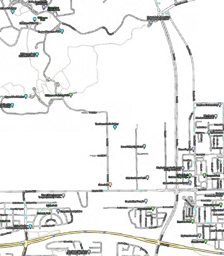
Document verification

 Job title                                    Morley Ellenbrook Line (MEL) - Project Definition Plan                       Job number
                                              (PDP)                                                                        267138-00
 Document title                               Flooding and Hydrology Report                                                File reference

 Document ref                                 MEL-MNO-ARUP-DR-RPT-0001
 Revision                 Date                Filename                 MEL-MNO-ARUP-DR-RPT-0001
 A-Draft                  11 Sept             Description              DRAFT 50% Design Confirmation Stage
                          2019
                                                                       Prepared by            Checked by                   Approved by
                                                                                              Reviewer -Greg
                                                                                              Rogencamp
                                                                                              P1 manager - Julia
                                                                                              Summers
                                                                       SRE-Matt                                            SEM - Sunil
                                              Name                                            P2 & P3 manager -
                                                                       Stovold                                             Bhogal
                                                                                              Lyndsay Hammond
                                                                                              P4 & P5 manager - Alistair
                                                                                              Avern-Taplin
                                                                                              APM - Zoe Wilks
                                              Signature

 B                        22     Filename                              MEL-MNO-ARUP-DR-RPT-0001
                          Novemb Description                           WIP- 100% Design confirmation stage
                          er
                                                                       Prepared by            Checked by                   Approved by
                                                                                              Discipline Reviewer –
                                                                                              Greg Rogencamp
                                                                       Steven Voss                                         SEM - Sunil
                                              Name
                                                                                                                           Bhogal
                                                                                              Hong Vu

                                              Signature

 C- FINAL                 18 Dec              Filename                 MEL-MNO-ARUP-DR-RPT-0001
                          2019                Description              Final PDP Issue
                                                                       Prepared by            Checked by                   Approved by

MEL-MNO-ARUP-DR-RPT-0001 | D – FINAL | 28 February 2020 | Arup
C:\PROJECTWISE\PER_PROJECTS\GLOBAL_ANDREW.SMETHERHAM\DMS70070\MEL-MNO-ARUP-DR-RPT-0001.DOCX
Discipline Reviewer –
Greg Rogencamp
P2 & P3 manager - SEM - Sunil
Name SSteven Voss Lyndsay Hammond Bhogal
P4 & P5 manager - Alistair
Avern-Taplin
Signature
D- FINAL 28 Feb Filename MEL-MNO-ARUP-DR-RPT-0001
2020 Description Final PDP Issue – Updated to incorporate final PTA/
METRONET comments and new inputs provided for Morley,
Noranda and Whiteman Park precincts (as applicable) which
were agreed with METRONET after the 100% PDP submission.
Prepared by Checked by Approved by
P2 & P3 manager -
SRE-Matt Lyndsay Hammond SEM - Sunil
Name
Stovold Bhogal
APM – Zoe Wilks
Signature
Issue Document verification with document
MEL-MNO-ARUP-DR-RPT-0001 | D – FINAL | 28 February 2020 | Arup
C:\PROJECTWISE\PER_PROJECTS\GLOBAL_ANDREW.SMETHERHAM\DMS70070\MEL-MNO-ARUP-DR-RPT-0001.DOCX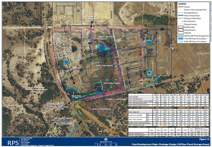
METRONET                                                                                                 Morley Ellenbrook Line (MEL) - Project Definition Plan (PDP)
                                                                                                                                     Flooding and Hydrology Report

           Contents
                                                                                                                                             Page

           1                Glossary                                                                                                            1

           2                Project description                                                                                                 2
                            2.1                Summary                                                                                          2
                            2.2                Status of Project Definition Plan                                                                4

           3                Scope development                                                                                                   7
                            3.1                Scope of Work                                                                                    7
                            3.2                Requirements                                                                                     8

           4                Basis of Design                                                                                                     9
                            4.1                Standards and Codes                                                                             9
                            4.2                Standard Units                                                                                  9
                            4.3                Design criteria                                                                                 9
                            4.4                Design life                                                                                    10
                            4.5                Deliverables                                                                                   10

           5                Design                                                                                                            11
                            5.1                Design Development                                                                             11
                            5.2                Design Risks, Assumptions, Issues, Dependencies,
                                               Opportunity and Constraints                                                                    32
                            5.3                Non-compliances                                                                                32
                            5.4                Third party verification                                                                       32
                            5.5                Constructability                                                                               32

           Appendices

           Appendix A –Drawings/ sketches

           Appendix B – RAATM

           Appendix C - SAR

           Appendix D – RAIDOC

           Appendix E – IDC Certificate

           Appendix F – IDR Closeout Record Log/ DRN and IDR register

           Appendix G Existing case

           Appendix H – Design case

           Appendix I – Impact maps

           MEL-MNO-ARUP-DR-RPT-0001 | D – FINAL | 28 February 2020 | Arup
           C:\PROJECTWISE\PER_PROJECTS\GLOBAL_ANDREW.SMETHERHAM\DMS70070\MEL-MNO-ARUP-DR-RPT-0001.DOCX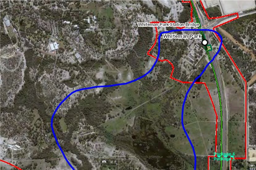
METRONET                                                                                                 Morley Ellenbrook Line (MEL) - Project Definition Plan (PDP)
                                                                                                                                     Flooding and Hydrology Report

           1                     Glossary
           Table 1 - Glossary
             Abbreviation                                       Description
             AMS                                                Arup’s Management System
             AEP                                                Annual Exceedance Probability
             ARI                                                Average Recurrence Interval
             BoD                                                Basis of Design
             BIM                                                Building Information Modelling
             CPE                                                Coordinating Project Engineer
             CAD                                                Computer Aided Drawing
             DRN                                                Document Review Notice
             DoT                                                Department of Transport
             DM                                                 Discipline Manager
             ELUP                                               Engineering and Land-Use Planning
             EMP                                                Engineering Management Plan
             GIS                                                Geographic Information System
             HV                                                 High Voltage
             IA                                                 Infrastructure Australia
             IDC                                                Interdisciplinary design checks
             IDR                                                Interdisciplinary Design Review
             LDC                                                Lead Design Consultant
             LV                                                 Low Voltage
             MRWA                                               Main Roads Western Australia
             MPU                                                Major Project Unit
             MEP                                                Mechanical, Electrical and Plumbing
             MEL                                                Morley-Ellenbrook Line
             N&I                                                Network and Infrastructure
             ONRSR                                              Office of the National Rail Safety Regulator
             PD                                                 Project Director
             PDP                                                Project Definition Plan
             PEs                                                Project Engineers
             PRS                                                Project Requirement Specification
             PTA                                                Public Transport Authority
             QA                                                 Quality Assurance
             RAIDOC                                             Risks, Assumptions, Issues, Dependencies, Opportunities,
                                                                Constraints
             RFI                                                Request for Information
             RAATM                                              Requirements analysis, allocation and traceability matrix
             SAR                                                Safety Assurance Report
             SiD                                                Safety in Design
             SMP                                                Safety Management Plan
             SER                                                Scope and Engineering Review
             SCADA                                              Supervisory Control and Data Acquisition
             SEM                                                Suppliers Engineering Manager
             SRE                                                Suppliers Responsible Engineers
             SESA                                               Systems Engineering and Safety Assurance
             SEMP                                               Systems Engineering Management Plan

           MEL-MNO-ARUP-DR-RPT-0001 | D – FINAL | 28 February 2020 | Arup                                                               Page 1
           C:\PROJECTWISE\PER_PROJECTS\GLOBAL_ANDREW.SMETHERHAM\DMS70070\MEL-MNO-ARUP-DR-RPT-0001.DOCX
METRONET                                                                                                 Morley Ellenbrook Line (MEL) - Project Definition Plan (PDP)
                                                                                                                                     Flooding and Hydrology Report

           2                     Project description

           2.1                   Summary
           The proposed Morley Ellenbrook Line (MEL) involves six integrated station
           precincts at Bayswater, Morley, Noranda, Malaga, Whiteman Park and Ellenbrook
           (and future-proofing for an additional station at Bennett Springs) and 21km of
           new track spurring from the existing Midland Line providing improved
           connections for existing and new communities in Perth’s northeast.

           Figure 1 – MEL project extents
           Arup, as Lead Design Consultant (LDC), is responsible for the preparation of a
           design that will allow the development of the Project Definition Plan (PDP). The
           MEL-MNO-ARUP-DR-RPT-0001 | D – FINAL | 28 February 2020 | Arup                                                               Page 2
           C:\PROJECTWISE\PER_PROJECTS\GLOBAL_ANDREW.SMETHERHAM\DMS70070\MEL-MNO-ARUP-DR-RPT-0001.DOCX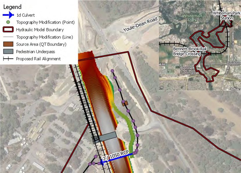
METRONET Morley Ellenbrook Line (MEL) - Project Definition Plan (PDP)
Flooding and Hydrology Report
design task has been divided into five geographical package areas and one site-
wide rail systems package as displayed in Figure 1.
The proposed rail line extends from the existing Bayswater Station on the
Midland Line, north to Ellenbrook Town Centre. The design encompasses the rail
stations and surrounding precincts of Bayswater (Package 1), Morley (Package 2),
Noranda (Package 2b), Malaga (Package 3), Whiteman Park (Package 4) and
Ellenbrook (Package 5) along with space-proofing for a station at Bennett
Springs. In addition to station precincts, the design incorporates site wide civil and
rail works within the project corridor and Tonkin Highway median. Major
structural elements of the proposed rail alignment include grade separated
structures (ramps, viaducts, dives, tunnels and new grade separated spans over and
under the rail corridor).
The purpose of the PDP design is to identify the site constraints, design solutions
and clear direction for the project with measurable inputs for the Quantity
Surveyor’s cost estimation. The PDP will be produced for, and in collaboration
with, PTA/ METRONET. The design will deliver on or enable METRONET to
meet its key requirements to:
Demonstrate sufficient survey and design evidence to confirm the chosen
route option will achieve the Project Requirements Specifications (PRS)
requirements, integration across disciplines, constructability, maintenance and
future proofing
Establish key design interfaces with proposed and existing features, design
constraints limitations and efficiencies
Provide project boundaries and definition to progress the Railway Enabling
Act, environmental impacts, land purchases and other key enabling activities.
The following disciplines below have collaborated throughout the design process:
Rail Systems – Permanent Way, Overhead Line Equipment, Signalling,
Earthing and Bonding, High Voltage / Low Voltage / Traction Power,
Communications and Operational Technology, Main Cable Route and Transit
Space
Civils – Earthworks, Utilities, Drainage, Flooding and Hydrology, Highways,
Civil Structures and Geotechnical, including Foundations
Stations and precincts– Architecture, Transport Planning, Urban Design,
Station Structures, Mechanical, Electrical, Hydraulic station Fire Services
Specialist – Systems and Safety Assurance, Fire and Life Safety, Tunnel
Ventilation, Digital (GIS, BIM, Visualisation, 3D Modelling) and CAD.
The PDP design will document the development of the multi-disciplinary
engineering design and systems design for each function and/or interface to
demonstrate that the proposed solution is consistent with the functional and
performance requirements of METRONET.
MEL-MNO-ARUP-DR-RPT-0001 | D – FINAL | 28 February 2020 | Arup Page 3
C:\PROJECTWISE\PER_PROJECTS\GLOBAL_ANDREW.SMETHERHAM\DMS70070\MEL-MNO-ARUP-DR-RPT-0001.DOCX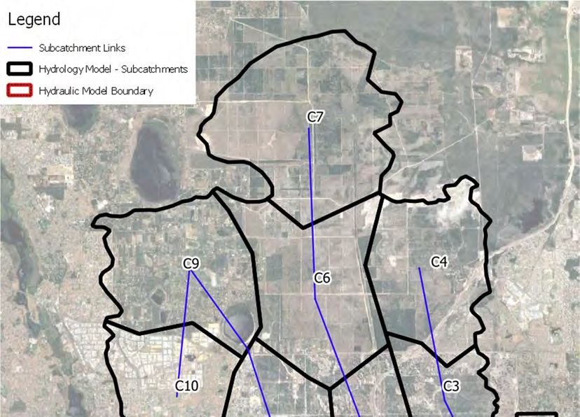
METRONET                                                                                                 Morley Ellenbrook Line (MEL) - Project Definition Plan (PDP)
                                                                                                                                     Flooding and Hydrology Report

           2.2                   Status of Project Definition Plan
           The MEL Draft PDP (Design Confirmation stage) was issued in August 2019 to
           METRONET/ PTA for review. The design produced for the December 2019 Final
           PDP Issue for each station precinct incorporated the first round of comments but
           was at various stages of development for each Package given there were some
           areas awaiting stakeholder and community feedback. In January 2020, final
           comments from PTA, METRONET and Main Roads WA were received and
           incorporated into the design.

           The below section seeks to provide clarity on the level of design as of February
           2020 for each discipline and package. This represents the final update to the MEL
           PDP design by Arup and its sub-consultants and as noted any further areas where
           design will need to progressed will be undertaken post PDP design by others.

           Package 1 – Baywater Station and Tonkin Tie-in
           A design for Package 1 – Baywater Station to Tonkin Entry was produced for
           MEL Draft PDP (Design Confirmation stage) and issued in August 2019. This
           allowed for the upgraded Bayswater Station and MEL tie-in to the Bayswater
           Station through to the Tonkin Entry and focussed on the area East of the Baywater
           platforms. An additional MEL Draft PDP (Design Confirmation stage) for the
           Baywater Turnback west of the platforms was issued on 29 October 2019.

           During the period between Design Confirmation and Final PDP Issue the
           Baywater Station and Turnback (BST) project progressed to tender design as a
           separate process. The shortlisted proponents were issued the Design Confirmation
           packages of MEL and a summary of risks and opportunities considered by the
           METRONET team for inclusion in that project. Arup has therefore not progressed
           any of the station or MEL tie-in to the Bayswater turnback design beyond Design
           Confirmation issue and as such these elements have not been re-issued for Final
           PDP issue.

           Documentation for Package 1 of the Final PDP Issue covers the line-wide
           elements east of the station to the Tonkin Highway entry.

           Package 2 – Morley Station and Tonkin Highway
           A design for Package 2 – Morley Station and Tonkin Highway was produced for
           MEL Draft PDP (Design Confirmation stage) and issued in August 2019. The
           design initially assumed that the Morley Bus Bridge would be installed adjacent to
           the in-situ Broun Avenue Bridge. During the intervening period between Design
           Confirmation Stage and FINAL PDP a decision was made by key stakeholders
           that Broun Avenue bridge would be demolished and replaced with an integrated
           Bus Bridge and Highway Bridge, the new Broun Avenue Bridge. This new design
           is reflected in the FINAL PDP Design Issue. In addition, minor comments were
           then received by stakeholders in January 2020 which were incorporated into the
           FINAL PDP submission in February 2020.

           Following the submission of the Final PDP Issue design in December 2019, a new
           Morley Station and precinct layout was selected by METRONET following

           MEL-MNO-ARUP-DR-RPT-0001 | D – FINAL | 28 February 2020 | Arup                                                               Page 4
           C:\PROJECTWISE\PER_PROJECTS\GLOBAL_ANDREW.SMETHERHAM\DMS70070\MEL-MNO-ARUP-DR-RPT-0001.DOCX
METRONET Morley Ellenbrook Line (MEL) - Project Definition Plan (PDP)
Flooding and Hydrology Report
further consultation with stakeholders. A civil general arrangement (GA) plan
[MEL-MNO-ARUP-CI-2150] and highways plan and profile [MEL-MNO-
ARUP-HW-DRG-2225 and MEL-MNO-ARUP-HW-DRG-2226] only have been
developed for this updated design. However, all other discipline design areas,
drawings and requirements have not been updated to correspond with this new
GA.
The commentary contained within this report corresponds with the previous GA
plan [MEL-MNO-ARUP-CI-2110]. The design will need be updated by others to
reflect the new GA following PDP phase at the next stage of design (post PDP
design).
Package 2B – Noranda Station
As of December 2019, the design development of Noranda station was on hold
awaiting the outcomes of the community consultation in this area on the potential
PnR layout. Therefore, no design for Noranda Station was undertaken before this
time and the DRAFT and FINAL MEL PDP deliverables issued in August 2019
and December 2019 do not contain station or precinct design drawings for this
station.
Following METRONET confirmation to proceed with the preferred layout, the
design for Noranda station progressed in January 2020. It should be noted that
during January and February 2020, only a preliminary design for Noranda station
and precinct has been undertaken during PDP phase including architectural, civil
engineering, highways, fire engineering, transport planning and urban design. The
design will need be updated and progressed by others to reflect the proposed
general arrangement (GA) [MEL-MNO-ARUP-CI-DRG-2210] and station design
following PDP phase at the next stage of design (post PDP design).
The design for Noranda Station and precinct is reflected in the FINAL PDP
deliverables issued in February 2020.
Package 3 – Malaga Station and Horse Swamp
A design for Package 3 – Malaga Station and Horse Swamp was produced for
MEL Draft PDP (Design Confirmation stage) and issued in August 2019. This
design was subsequently updated following comments from stakeholders and
issued as FINAL PDP in December 2019. Minor comments were then received by
stakeholders in January 2020 which were incorporated into the FINAL PDP
submission in February 2020.
Package 4 – Whiteman Park Station and New Lord Street
A design for Package 4 – Whiteman Park Station and New Lord Street was
produced for MEL Draft PDP (Design Confirmation stage) and issued in August
2019. This design was subsequently updated following comments from
stakeholders and issued as FINAL PDP in December 2019. It should be noted that
the submission in December 2019 did not include design for the precinct as this
area was on hold awaiting final comments and endorsement from METRONET.
MEL-MNO-ARUP-DR-RPT-0001 | D – FINAL | 28 February 2020 | Arup Page 5
C:\PROJECTWISE\PER_PROJECTS\GLOBAL_ANDREW.SMETHERHAM\DMS70070\MEL-MNO-ARUP-DR-RPT-0001.DOCXMETRONET Morley Ellenbrook Line (MEL) - Project Definition Plan (PDP)
Flooding and Hydrology Report
The main features within this package have been retained with the key changes
between Design Confirmation stage and Final PDP Stage including the following
components:
Addition of swales in parking bays (in line with WSUD principles)
Retention of existing buildings in Whiteman Park
Change bus interchange footprint (to “V” shape)
Incorporation of a stream / swale in the car park matching an existing ‘tree
line’.
Minor comments were received by stakeholders in January 2020 regarding the
station and wider package area which were incorporated into the FINAL PDP
submission in February 2020.
Package 5 – Ellenbrook Station
A design for Package 5 – Ellenbrook Station was produced for MEL Draft PDP
(Design Confirmation stage) and issued in August 2019. This design was
subsequently updated following comments from stakeholders and issued as
FINAL PDP in December 2019. Minor comments were then received by
stakeholders in January 2020 which were incorporated into the FINAL PDP
submission in February 2020.
No significant changes to the Ellenbrook Precinct have been made between
Design Confirmation Stage at Final PDP Issue, however, an alternative GA
[MEL-MNO-ARUP-CI-DRG-5150] has been produced to show where additional
parking may be added in the future.
MEL-MNO-ARUP-DR-RPT-0001 | D – FINAL | 28 February 2020 | Arup Page 6
C:\PROJECTWISE\PER_PROJECTS\GLOBAL_ANDREW.SMETHERHAM\DMS70070\MEL-MNO-ARUP-DR-RPT-0001.DOCXMETRONET Morley Ellenbrook Line (MEL) - Project Definition Plan (PDP)
Flooding and Hydrology Report
3 Scope development
3.1 Scope of Work
The flood assessment is confined to Package 3 area only where the greatest flood
risk to the proposed rail alignment was determined based on the hydrologic
complexity of the Bennett Brook rail crossing and upstream Horse Swamp area.
Elsewhere across the project, flood risk is considered to be low and will be
managed through conventional drainage design assessment means; such as
through the use of swale/basin infiltration and piped network conveyance
mechanisms.
3.1.1 Package 0
Not included in the Flooding and Hydrology scope.
3.1.2 Package 1
Not included in the Flooding and Hydrology scope.
3.1.3 Package 2
Not included in the Flooding and Hydrology scope.
3.1.4 Package 3
The scope of Flooding and Hydrology within Package Area 3 is to:
• Assess the flood risk to both rail and nearby residential development within
the vicinity of Horse Swamp and Bennett Brook
• Undertake flood modelling to assess rail/road flood immunity and the flood
impact on adjacent properties to site works at the Bennett Brook Crossing and
at the pedestrian underpass at Whiteman Park Station.
The indicative scope boundary is shown below within the blue polygon.
MEL-MNO-ARUP-DR-RPT-0001 | D – FINAL | 28 February 2020 | Arup Page 7
C:\PROJECTWISE\PER_PROJECTS\GLOBAL_ANDREW.SMETHERHAM\DMS70070\MEL-MNO-ARUP-DR-RPT-0001.DOCXMETRONET Morley Ellenbrook Line (MEL) - Project Definition Plan (PDP)
Flooding and Hydrology Report
Figure 2 - Indicative flood study boundary
3.2 Requirements
Following discussions with METRONET and City of Swan, it was identified that
previous endorsements by Department of Water (2015) supported additional flows
to be directed into Horse Swamp as a means for addressing reports that it has been
noticeably dry over previous years. Because of this, up to 3.3 m3/s of surface
runoff has been reportedly allowed to be conveyed to Horse Swamp from
developed areas to the east of New Lord Street during the 1% AEP event. This
flow has, therefore, been accounted for in the hydrologic and hydraulic model
development.
MEL-MNO-ARUP-DR-RPT-0001 | D – FINAL | 28 February 2020 | Arup Page 8
C:\PROJECTWISE\PER_PROJECTS\GLOBAL_ANDREW.SMETHERHAM\DMS70070\MEL-MNO-ARUP-DR-RPT-0001.DOCXMETRONET Morley Ellenbrook Line (MEL) - Project Definition Plan (PDP)
Flooding and Hydrology Report
4 Basis of Design
4.1 Standards and Codes
The surface water assessment, drainage design and protection works must
conform with sound hydrological and hydraulic practices and must conform with
the documents in Table 2:
Table 2 – Precedence of reference documents for flooding and hydrology
Precedence Title
A Australian Rainfall and Runoff: A Guide to Flood Estimation (2019)
B Department of Water and Environmental Regulation, Stormwater
Management Manual for Western Australia (2007)
C Department of Water and Environmental Regulation, Decision Process for
Stormwater Management in WA (2009)
D Austroads’ Guide to Road Design – Parts 5, 5A and 5B
E Institution of Engineers Australia, Australian Rainfall and Runoff: A
Guide to Flood Estimation. Volumes 1 and 2. (1998)
F Austroads Waterway Design – A Guide to the Hydraulic Design of
Bridges, Culverts and Floodways (1994)
G Subsurface Drainage of Road Structures. RJ Gerke, Australian Road
Research Board Special Report SR35 (1987)
H NAASRA Guide to the Design of Road Surface Drainage (1986)
4.1.1 Gaps in Standards/Code of Practice
NA
4.2 Standard Units
The International System of Units (SI units) will be used throughout.
All design levels will be to Australian Height Datum (AHD) unless otherwise
noted.
All plan coordinates will be to Perth Coastal Grid PCG94 coordinates, based on
the Geocentric Datum of Australia 1994 (GDA94).
4.3 Design criteria
As a minimum the design must consider the following:
An assessment of surface water hydrology must be undertaken as part of the
assessment
Upstream flooding effects to the proposed bridge over Bennett Brook are to
have no adverse impacts to existing properties
MEL-MNO-ARUP-DR-RPT-0001 | D – FINAL | 28 February 2020 | Arup Page 9
C:\PROJECTWISE\PER_PROJECTS\GLOBAL_ANDREW.SMETHERHAM\DMS70070\MEL-MNO-ARUP-DR-RPT-0001.DOCXMETRONET Morley Ellenbrook Line (MEL) - Project Definition Plan (PDP)
Flooding and Hydrology Report
The proposed bridge over Bennett Brook is to be designed to ensure a
minimum 500 mm freeboard to the bridge soffit during the 1% AEP
The railway formation and corridor must be drained to prevent scouring,
washaways or saturation.
4.4 Design life
NA
4.5 Deliverables
Table 3 lists the deliverables for the final PDP issue design stage.
Table 3 – Final PDP design stage deliverables
Doc Number Doc Title
OVERALL REPORT
MEL-MNO-ARUP-DR-RPT- MEL PDP PHASE – FLOODING AND HYDROLOGY
0001 REPORT
MEL-MNO-ARUP-DR-RPT-0001 | D – FINAL | 28 February 2020 | Arup Page 10
C:\PROJECTWISE\PER_PROJECTS\GLOBAL_ANDREW.SMETHERHAM\DMS70070\MEL-MNO-ARUP-DR-RPT-0001.DOCXMETRONET Morley Ellenbrook Line (MEL) - Project Definition Plan (PDP)
Flooding and Hydrology Report
5 Design
5.1 Design Development
In order to quantify the impacts of the proposed design on catchment flooding,
hydrologic and hydraulic analyses were undertaken for pre and post construction
conditions. The following sections describe the approach which was undertaken to
complete the flood impact assessment as well as summarising model development
and key model results.
5.1.1 Catchment Overview
The Bennett Brook catchment is a tributary of the Swan River and has a
catchment area of approximately 173km2 (delineated to the Reid Highway /
Bennett Brook Crossing). The extent of the catchment is shown in Figure 5,
located in section 5.1.3.
The proposed location where the proposed rail alignment will cross the Bennett
Brook is just over 5km upstream of the Bennett Brook and Swan River
confluence. An overview of the hydraulic model extent, location of the proposed
rail alignment and the proposed road upgrade and Whiteman Park Station is
shown in Figure 3.
MEL-MNO-ARUP-DR-RPT-0001 | D – FINAL | 28 February 2020 | Arup Page 11
C:\PROJECTWISE\PER_PROJECTS\GLOBAL_ANDREW.SMETHERHAM\DMS70070\MEL-MNO-ARUP-DR-RPT-0001.DOCXMETRONET Morley Ellenbrook Line (MEL) - Project Definition Plan (PDP)
Flooding and Hydrology Report
Figure 3 – Area of Interest
5.1.2 Available Data and Existing Studies
Three existing studies have been undertaken in the area of interest for the Bennett
Brook and Horse Swamp area. These existing studies were reviewed to provide
context and guidance for hydrologic model parameters and model inflows.
Findings of previous studies are discussed below.
Swan and Helena Rivers Flood Study: Hydrology (HARC, 2016)
HARC was contracted by the Eastern Metropolitan Regional Council to undertake
a review of the design flood hydrology for the Swan River, with the intention of
using the latest available techniques to establish flows for the 10% AEP event
through to the probable maximum flood (PMF).
The study utilised the RORB runoff routing program to simulate flood
hydrographs for the full Swan Avon River system which has a catchment area of
124,000km2.
MEL-MNO-ARUP-DR-RPT-0001 | D – FINAL | 28 February 2020 | Arup Page 12
C:\PROJECTWISE\PER_PROJECTS\GLOBAL_ANDREW.SMETHERHAM\DMS70070\MEL-MNO-ARUP-DR-RPT-0001.DOCXMETRONET Morley Ellenbrook Line (MEL) - Project Definition Plan (PDP)
Flooding and Hydrology Report
Due to the difference in size of the study area between this broader catchment
study, and the hydrological assessment of the Bennett Brook and Horse Swamp
area, there is a limited amount of data and parameters that can be correlated in
terms of hydrologic model calibration, particularly with there being limited data
available for the lower end of the Swan River around Bennett Brook.
The kc value adopted within the RORB model was varied per each interstation
area, and the lower end of the model, including the Bennet Brook tributary utilised
a kc value computed from C0.8 and dav. It was noted that there was limited gauging
information that could be used to improve this estimate.
A proportional loss model was adopted within the RORB model, with loss
parameters also varying by interstation areas. The loss parameters adopted for the
Swan River sub-catchments (including Bennett Brook) were 100mm initial loss
and a proportional loss coefficient of 0.35. These loss parameters were adopted in
the hydrological modelling developed by Arup for the Bennet Brook catchment
which is discussed further in Section 5.1.3.
Bennett Brook Flood Study (Gutteridge Haskins & Davey Pty Ltd, 1988)
The aim of the Bennett Brook Flood Study was to estimate catchment runoff rates
and consequently extent and level of flooding in Bennett Brook, between the
Swan River confluence and Mussel Pool. The hydrological modelling undertaken
for the Bennett Brook Flood Study utilised RORB version 3.7 and was completed
in adherence with the 1987 version of the Australian Rainfall and Runoff
Guidelines.
The catchment modelled excluded a portion north of Gnangara Road as based
upon field inspections and discussions with the Authority, the excluded area was
highly permeable and unlikely to generate any runoff. Furthermore, Gnangara
Road had no culverts to allow cross drainage and consequently in large events the
flow would bank up behind the road embankment and eventually infiltrate into the
ground. For this reason, the northern portion of the catchment was excluded from
the Bennett Brook Flood Study. The hydrologic model which has been developed
to assess the process rail alignment, covers the full Bennett Brook catchment,
which is conservative in comparison to the study completed in 1988 as it includes
the portion of the catchment north of Gnangara Road.
The flows from the Bennett Brook Flood Study hydrological model were reported
at several locations for various design events. The flows for the catchment
reported at Marshall Road and Benara Road are summarised in the table below.
Table 4 – Final PDP Issue design stage deliverables
Reporting Peak Flow (m3/s)
Location
10 year ARI 25 year ARI 50 year ARI 100 year ARI
Marshall Road 21 30 34 41
Benara Road 38 52 59 72
Urban Water Management Plan: Lot 15 to 17 Woollcott Avenue, Whiteman
Edge Local Structure Plan 1C (RPS, 2016)
MEL-MNO-ARUP-DR-RPT-0001 | D – FINAL | 28 February 2020 | Arup Page 13
C:\PROJECTWISE\PER_PROJECTS\GLOBAL_ANDREW.SMETHERHAM\DMS70070\MEL-MNO-ARUP-DR-RPT-0001.DOCXMETRONET Morley Ellenbrook Line (MEL) - Project Definition Plan (PDP)
Flooding and Hydrology Report
RPS produced an Urban Water Management Plan on behalf of Stockland
Development Pty Ltd to support the subdivision of the western three-quarters of
Whiteman Edge Local Structure Plan. The works included assessment of the
existing environment, including geology, hydrology, surface hydrology and
groundwater and also proposed various water conservation strategies. The
hydrology assessment undertaken for this modelling was completed using
XPSWMM. Catchment delineation and flow paths are shown in Figure 4.
Figure 4 – XPSWMM Model Geometry (RPS, 2016)
The peak flow rate for the 1% AEP event for the outflow drain to Horse Swamp is
3.3m3/s. The hydrologic model was calibrated to replicate this peak flow rate for
the 1%AEP event.
5.1.3 Hydrologic Modelling
A XP-Rafts model was developed to simulate the routing of rainfall throughout
the study catchment and produce inflow hydrographs for application to the
hydraulic model.
XPRafts Overview
XPRafts is a non-linear runoff routing model suitable for both urban and rural
catchments. It uses the Laurenson non-linear runoff routing approach to develop a
stormwater runoff hydrograph from either recorded rainfall or design rainfall
based upon IFD data and temporal patterns. XPRafts can utilise a number of loss
models including initial/continuing, initial/proportional and ARBM water balance
model. Hydraulic routing can also be tailored to the catchment characteristics by
utilising either simple Manning’s based lagging or the Muskingum-Cunge
method.
MEL-MNO-ARUP-DR-RPT-0001 | D – FINAL | 28 February 2020 | Arup Page 14
C:\PROJECTWISE\PER_PROJECTS\GLOBAL_ANDREW.SMETHERHAM\DMS70070\MEL-MNO-ARUP-DR-RPT-0001.DOCXMETRONET Morley Ellenbrook Line (MEL) - Project Definition Plan (PDP)
Flooding and Hydrology Report
Hydrologic model geometry
The hydrologic model boundary has been delineated down to the Reid highway
encompassing a total area of 173km2. The catchment has been further delineated
into 13 subareas creating various reporting locations within the catchment for
application to the hydraulic model. The catchment includes a combination of both
undeveloped rural areas and developed residential areas. Consequently, the
Bennett Brook catchment comprises of a combination of both pervious and
impervious areas. The geometry of the hydrologic model is shown in Figure 5.
Figure 5 – Hydrologic model geometry
Hydrologic model parameters
The hydrologic model was developed utilising the latest available data from the
2019 Australian Rainfall and Runoff guidelines. This information was sourced
from both IFD and datahub web sources.
MEL-MNO-ARUP-DR-RPT-0001 | D – FINAL | 28 February 2020 | Arup Page 15
C:\PROJECTWISE\PER_PROJECTS\GLOBAL_ANDREW.SMETHERHAM\DMS70070\MEL-MNO-ARUP-DR-RPT-0001.DOCXMETRONET Morley Ellenbrook Line (MEL) - Project Definition Plan (PDP)
Flooding and Hydrology Report
Within the hydrologic model, routing between catchments has been defined by
use of manually calculated lag times and an initial/proportional loss approach was
adopted for all sub catchment areas. A summary of model parameters is
summarised in Table 5.
MEL-MNO-ARUP-DR-RPT-0001 | D – FINAL | 28 February 2020 | Arup Page 16
C:\PROJECTWISE\PER_PROJECTS\GLOBAL_ANDREW.SMETHERHAM\DMS70070\MEL-MNO-ARUP-DR-RPT-0001.DOCXMETRONET Morley Ellenbrook Line (MEL) - Project Definition Plan (PDP)
Flooding and Hydrology Report
Table 5 – Summary of hydrologic model parameters
Parameter Value
Hydrologic Approach ARR 2019 – Ensemble Method
IFD extraction point (Lat/Long, decimal degrees) -31.818, 115.924
Date of data download 18th of July 2019.
Temporal pattern zone Southern & South Western Flatlands (FLTWest)
Loss approach Initial/Proportional
Initial loss (mm) 100
Loss coefficient 0.35
Routing Method Lag times calculated based upon low velocities
due to wide channels and low slopes.
Hydrologic Model Outputs and Model Validation
Due to the limited data available to calibrate the Bennett Brook hydrologic model,
information has been sourced from previous studies and tools such as the
Regional Flood Frequency Estimation Model (RFFE) to provide validation to the
hydrologic model outputs.
There are some gauges in the adjacent catchments. However, they do not provide
data of sufficient quality to assist in model calibration. There are also several
gauges located along the Swan River. However, these gauges are for the broader
catchment and are located upstream of the Bennett Brook confluence.
It is noted that there is a gauge downstream of the area of interest along the
Bennett Brook. The gauge data extends from 1988 onwards. However, the flows
and levels recorded appear to be controlled by the downstream storage area, as
flows range from 0m3/s to only 4.5m3/s. Consequently, while some gauge data
exists, there is minimal data which can be utilised to aid in the calibration of the
hydrologic model.
The work completed by HARC in 2016 suggests that a 100mm initial loss and a
proportional loss coefficient of 0.35 provides a reasonable calibration across most
of the Swan River sub catchments, of which the Bennett Brook is located. These
loss values were adopted within the XPRafts model in conjunction with data from
the latest Australian Rainfall and Runoff guidelines including temporal patterns
and IFD data. Utilising this information, the suite of ensemble events was
simulated through XPRafts. Results indicated that for a 1% AEP event, the critical
duration was shown as 72 hours for the Bennett Brook catchment, with a peak
flow of 43.9m3/s. The box and whisker plot showing the spread of peak flow rates
across multiple durations is shown in Figure 6.
MEL-MNO-ARUP-DR-RPT-0001 | D – FINAL | 28 February 2020 | Arup Page 17
C:\PROJECTWISE\PER_PROJECTS\GLOBAL_ANDREW.SMETHERHAM\DMS70070\MEL-MNO-ARUP-DR-RPT-0001.DOCXMETRONET Morley Ellenbrook Line (MEL) - Project Definition Plan (PDP)
Flooding and Hydrology Report
Figure 6 – 1% AEP Box and Whisker Plot
In comparison, the RFFE estimates for this catchment suggest a 1% AEP peak
flow of 48.7m3/s, which is within 10% of the hydrologic model. The peak flow
rate from the hydrologic model is also in the vicinity of values presented in the
Bennett Brook Flood Study completed in 1988, which reported that at Marshall
Road a 1% AEP of 41m3/s was expected. The reporting location for the XPRafts
model is just downstream of the Marshall Road location reported in the Bennett
Brook Flood Study.
Initial results for the 2% AEP and 10% AEP events indicated that utilising the
same loss parameters of 100mm initial loss and a proportional loss coefficient of
0.35 resulted in disproportional peak flood estimates for the smaller events which
did not align with available validation data such as the RFFE model estimates. As
described in the work by HARC, the difficulty introduced by a proportional loss is
that it is considered to vary with AEP, and due to the lack of available calibration
data, the ability to identify a proportional loss coefficient for each AEP is
unrealistic. Consequently, a pragmatic approach was adopted to scale the 1% AEP
flood hydrograph by equivalent ratios of the RFFE estimates.
The raw data from nearby gauged catchments utilised for the RFFE estimates was
analysed and once catchments with areas significantly larger the Bennett Brook
catchment or shape factors which were dissimilar were excluded, a linear
relationship was developed relating the peak flow estimate to the catchment area.
These relationships for the 1% AEP, 2% AEP and 10% AEP events are shown in
Figure 7 to Figure 9.
MEL-MNO-ARUP-DR-RPT-0001 | D – FINAL | 28 February 2020 | Arup Page 18
C:\PROJECTWISE\PER_PROJECTS\GLOBAL_ANDREW.SMETHERHAM\DMS70070\MEL-MNO-ARUP-DR-RPT-0001.DOCXMETRONET Morley Ellenbrook Line (MEL) - Project Definition Plan (PDP)
Flooding and Hydrology Report
Figure 7 – Linear Relationship of Catchment Area to RFFE Peak Flood estimates
for a 1% AEP Event
Figure 8 – Linear Relationship of Catchment Area to RFFE Peak Flood estimates
for a 2% AEP Event
MEL-MNO-ARUP-DR-RPT-0001 | D – FINAL | 28 February 2020 | Arup Page 19
C:\PROJECTWISE\PER_PROJECTS\GLOBAL_ANDREW.SMETHERHAM\DMS70070\MEL-MNO-ARUP-DR-RPT-0001.DOCXMETRONET Morley Ellenbrook Line (MEL) - Project Definition Plan (PDP)
Flooding and Hydrology Report
Figure 9 – Linear Relationship of Catchment Area to RFFE Peak Flood estimates
for a 10% AEP Event
Using the linear relationships shown scaling factors for the 2% and 10% AEP
events were determined. A summary of peak flood estimates and scaling factors
are shown in Table 6. The corresponding inflow hydrographs for application to
the hydraulic model are also shown in Figure 10.
Table 6 – Summary of Peak Design Flows
AEP Event Peak Flow (m3/s) Critical Duration (mins) Temporal Pattern
10% 23.9 Scaled off 1% AEP event by a factor of 54% based
upon analysis of RFFE peak flows.
2% 36.0 Scaled off 1% AEP event by a factor of 82% based
upon analysis of RFFE peak flows.
1% 43.9 4320 4
*Peak flows have been reported at catchment C2b.
MEL-MNO-ARUP-DR-RPT-0001 | D – FINAL | 28 February 2020 | Arup Page 20
C:\PROJECTWISE\PER_PROJECTS\GLOBAL_ANDREW.SMETHERHAM\DMS70070\MEL-MNO-ARUP-DR-RPT-0001.DOCXMETRONET Morley Ellenbrook Line (MEL) - Project Definition Plan (PDP)
Flooding and Hydrology Report
Figure 10 – Summary of Main Upstream Inflow Hydrographs (C2b) for Bennett Brook
Hydraulic Model
The flows which have been applied to the Whiteman Park area have been based
upon the peak flow of 3.3m3/s as reported by the existing RPS report which has
utilised more detailed modelling using XPSwmm to represent the catchment and
storages within the urban area. Similarly, to the main hydraulic model inflow, the
Whiteman Park area has been scaled by a factor of 82% and 54% for the 2% AEP
and 10% AEP events respectively.
5.1.4 Hydraulic Modelling
Model Overview
The hydraulic modelling for the assessment of the Bennett Brook rail crossing has
been completed using TUFLOW. TUFLOW is a two-dimensional unsteady flow
model which estimates flood levels and velocities throughout a fixed grid area by
solving two-dimensional depth averaged momentum and continuity equations for
free surface flow. Within the hydraulic model, all one-dimensional elements such
as culverts and pipes are managed by the ESTRY solver which utilises St-Venants
equations. TUFLOW and ESTRY engines are hydrodynamically linked to ensure
continuity between 1D and 2D domains.
The version of TUFLOW which has been utilised for this study is the 2018-03-
AD release which features the Heavily Parallelised Compute (HPC) solver. In
short, the HPC solver uses adaptive time steps and GPU processing to decrease
the simulation run time.
MEL-MNO-ARUP-DR-RPT-0001 | D – FINAL | 28 February 2020 | Arup Page 21
C:\PROJECTWISE\PER_PROJECTS\GLOBAL_ANDREW.SMETHERHAM\DMS70070\MEL-MNO-ARUP-DR-RPT-0001.DOCXMETRONET Morley Ellenbrook Line (MEL) - Project Definition Plan (PDP)
Flooding and Hydrology Report
Model Development
A basic summary of the model is presented in Table 7 and shown in Figure 11.
Table 7 – Hydraulic Model Summary
Parameter Information
Model Build Development Date November 2019
AEP’s Events Assessed 10%, 2% and 1% AEP
Hydrologic Modelling Approach Inflows determined through XPRafts hydrologic model and
applied through SA polygons within the 2d domain.
TUFLOW Version 2018-03-AD-iSP (HPC GPU)
Model Extent Refer to Figure 11
Grid Size 5m x 5m
Topographic Data 5m national DEM (ELVIS, 2019), 2m LiDAR (Department
of Environment and Water, 2019) and 2m gridded survey
data (Main Road WA, 2019).
Roughness Spatially varying roughness values which align with
standard industry values. Refer to Table 8 below which
outlines the adopted values.
Eddy Viscosity and Turbulence Smagorinsky (default)
Downstream Model Boundary Height Time boundary – based upon constant water level
Hydraulic Model Time Step Adaptive timestep
Modelled Scenarios Existing (pre construction) and Design cases (post
construction).
MEL-MNO-ARUP-DR-RPT-0001 | D – FINAL | 28 February 2020 | Arup Page 22
C:\PROJECTWISE\PER_PROJECTS\GLOBAL_ANDREW.SMETHERHAM\DMS70070\MEL-MNO-ARUP-DR-RPT-0001.DOCXMETRONET Morley Ellenbrook Line (MEL) - Project Definition Plan (PDP)
Flooding and Hydrology Report
Figure 11 – Hydraulic model schematic
Model Extent
The model extent is shown in Figure 11. The upstream boundary along Bennett
Brook has been defined approximately 1km upstream of the proposed alignment.
The Horse Swamp area has also been included in the model, with the upper end of
the model extending past the eastern side of New Lord Street to enable the
proposed diversion drains and proposed road and rail alignments to be
represented.
Model Boundaries
All inflow boundaries within the hydrologic model have been represented by flow
vs time boundaries (QT) applied through either boundary condition lines, or
source area polygons. Model inflows are based upon XPRafts outputs.
All outflow boundaries are based upon height-discharge (HQ) relationships.
TUFLOW develops height-discharge relationships based upon the topography
MEL-MNO-ARUP-DR-RPT-0001 | D – FINAL | 28 February 2020 | Arup Page 23
C:\PROJECTWISE\PER_PROJECTS\GLOBAL_ANDREW.SMETHERHAM\DMS70070\MEL-MNO-ARUP-DR-RPT-0001.DOCXMETRONET Morley Ellenbrook Line (MEL) - Project Definition Plan (PDP)
Flooding and Hydrology Report
elevations along the boundary line, and the downstream energy slope. Model
boundaries are shown in Figure 11. An initial water level was also defined in the
Horse Swamp area, as highlighted in Figure 11.
Model Topography
The topography which has been utilised within the hydraulic model development
has utilised a combination of both 5m gridded data derived from LiDAR (Elvis,
2019), 2m LiDAR data (Department of Environment and Water, 2019) throughout
critical project areas, and 2m gridded data derived from survey through the New
Lord Street Area (Main Roads WA, 2019).
In addition to the base gridded topography data, a number of topographic
modifications have been enforced in the model. These modifications include:
Drainage channels and gully representation through the Horse Swamp area
and on the eastern side of Lords Road
Design scenario topographic changes such as proposed road and rail
embankments.
Roughness Values
Material roughness has been applied on a categorical basis. Specific roughness
values for each category applied in the model are detailed in Table 8. The spatial
representation of Manning’s ‘n’ values is shown in Figure 12.
Table 8 – Material Classifications
ID Material Description Manning’s n
1 Rural cleared land (default) 0.040
2 Riparian Vegetation (open pervious with trees) 0.090
3 Waterbody 0.030
4 Road 0.025
5 Urban 0.200
6 Open vegetation moderate – shrubs 0.060
7 Waterway area – cleared post construction 0.050
Structure Blockage
The proposed design structures, including both the single span bridge and the
culverts at the Bennett Brook crossing and at New Lords Street crossing, have
been represented within the hydraulic model without inclusion of blockage
factors. This approach has been adopted due to the design being in a concept
phase, and the proposed rail and road levels in the Bennett Brook crossing and
Whiteman Park precinct being significantly higher than the 1% AEP water level.
However, it is recommended that in the detailed design phase, sensitivity
assessments be undertaken for culvert blockage scenarios.
MEL-MNO-ARUP-DR-RPT-0001 | D – FINAL | 28 February 2020 | Arup Page 24
C:\PROJECTWISE\PER_PROJECTS\GLOBAL_ANDREW.SMETHERHAM\DMS70070\MEL-MNO-ARUP-DR-RPT-0001.DOCXMETRONET Morley Ellenbrook Line (MEL) - Project Definition Plan (PDP)
Flooding and Hydrology Report
Figure 12 – Roughness definition
MEL-MNO-ARUP-DR-RPT-0001 | D – FINAL | 28 February 2020 | Arup Page 25
C:\PROJECTWISE\PER_PROJECTS\GLOBAL_ANDREW.SMETHERHAM\DMS70070\MEL-MNO-ARUP-DR-RPT-0001.DOCXMETRONET Morley Ellenbrook Line (MEL) - Project Definition Plan (PDP)
Flooding and Hydrology Report
5.1.5 Existing Case Results
In order to establish the baseline flood results, the 10%, 2% and 1% AEP events
were run through the existing case hydraulic model. Flood maps presenting the
height, depth and velocity results for these scenarios have been presented in
Appendix I.
The 1% AEP flood extent throughout the Bennett Brook area remains primarily
contained in the main channels, with peak depths of between 1.4m to 1.8m along
the centre of the Bennett Brook alignment. There are minor breakouts along
portions of the main channel, with depths in these areas typically ranging from
100mm to 500mm. Velocities throughout the channel are typically below 1m/s.
The water levels and velocities for the existing case events at the centre of the
proposed Bennett Brook Bridge are summarised in the table below.
Table 9 – Existing flood behaviours at the proposed Bennet Brook bridge crossing
AEP (%) Depth (m) Water Level (mAHD) Velocity (m/s)
1% 1.07 16.23 0.90
2% 0.97 16.14 0.87
10% 0.75 15.91 0.76
5.1.6 Proposed Design Details
Within the hydraulic model extent, there are two locations that interact with either
the main or minor channel areas. These areas are at the proposed crossing of
Bennett Brook, and the proposed Whiteman Station and New Lords Road
upgrade. An overview of the design elements at is shown in Figure 13 and Figure
14 for the Bennett Brook and Whiteman Station areas respectively.
MEL-MNO-ARUP-DR-RPT-0001 | D – FINAL | 28 February 2020 | Arup Page 26
C:\PROJECTWISE\PER_PROJECTS\GLOBAL_ANDREW.SMETHERHAM\DMS70070\MEL-MNO-ARUP-DR-RPT-0001.DOCXMETRONET Morley Ellenbrook Line (MEL) - Project Definition Plan (PDP)
Flooding and Hydrology Report
Figure 13 – Proposed Bennett Brook Crossing
The proposed design at the Bennett Brook crossing features a 26m single span
bridge with 2 / 600 Reinforced Concrete Pipes (RCPs) each side of the bridge.
The soffit level of the bridge is approximately 17.15mAHD.
The bridge has been represented within the hydraulic model through use of a
layered flow constriction region and the culverts have been represented as part of
a 1D network layer.
MEL-MNO-ARUP-DR-RPT-0001 | D – FINAL | 28 February 2020 | Arup Page 27
C:\PROJECTWISE\PER_PROJECTS\GLOBAL_ANDREW.SMETHERHAM\DMS70070\MEL-MNO-ARUP-DR-RPT-0001.DOCXMETRONET Morley Ellenbrook Line (MEL) - Project Definition Plan (PDP)
Flooding and Hydrology Report
Figure 14 – Whiteman Street Park Precinct
Through the Whiteman Park Station area, the rail alignment will be a viaduct, and
will have minimal impact on the local flood behaviours. However, there are
numerous other design features such as the design upgrade to New Lord Street
and the inclusion of a pedestrian underpass which would impact flow paths and
local drainage.
The proposed design features a 1.5m deep trapezoidal drain with a 2m wide base.
The drain will tie into the culvert crossing under Youle-Dean Road and divert
flow through around the pedestrian underpass to the 2 / 1050 RCP proposed, as
shown in Figure 14.
The key intention for modelling the Whiteman Park Area is to ensure that the
proposed pedestrian underpass has adequate flood immunity to remain accessible
in a 1% AEP event.
MEL-MNO-ARUP-DR-RPT-0001 | D – FINAL | 28 February 2020 | Arup Page 28
C:\PROJECTWISE\PER_PROJECTS\GLOBAL_ANDREW.SMETHERHAM\DMS70070\MEL-MNO-ARUP-DR-RPT-0001.DOCXMETRONET Morley Ellenbrook Line (MEL) - Project Definition Plan (PDP)
Flooding and Hydrology Report
5.1.7 Design Case Results and Impact Assessment
The design case results are generally similar to the existing case results with
isolated areas where impacts are observed due to the proposed design. The
impacts to flood behaviours are discussed in the following sections.
Impact Assessment at Bennett Brook Crossing
The impacts of the proposed Bennett Brook crossing are isolated to the area
immediately upstream of the alignment and does not have significant impact to
adjacent properties. Design case maps are shown in Appendix J and flood impact
maps are shown in Appendix K. The impact of the proposed design on flood level
and extent is shown spatially in the figure below.
Figure 15 – 1% AEP flood impact (Design Case minus Existing Case)
MEL-MNO-ARUP-DR-RPT-0001 | D – FINAL | 28 February 2020 | Arup Page 29
C:\PROJECTWISE\PER_PROJECTS\GLOBAL_ANDREW.SMETHERHAM\DMS70070\MEL-MNO-ARUP-DR-RPT-0001.DOCXMETRONET Morley Ellenbrook Line (MEL) - Project Definition Plan (PDP)
Flooding and Hydrology Report
As shown in Figure 15, the flood extent is increased upstream of the proposed
crossing. However, these increases are primarily in the direction of open
undeveloped area and has negligible impacts on adjacent properties.
With regards to changes in levels and peak velocities, a maximum afflux of
approximately 430mm is observed upstream of the bridge structure and an
increase in peak flood velocities of 1.7m/s.
Design case flood levels, velocities and flood impact are summarised in the table
below for all simulated AEP events.
Table 10 – Design case flood behaviour at proposed Bennet Brook bridge crossing
AEP Depth (m) Water Level Velocity Change in Peak Change in Peak
(%) (mAHD) (m/s) Flood Level (m) Flood Velocity (m/s)
1% 1.50 16.66 2.59 0.43 1.69
2% 1.33 16.49 2.39 0.36 1.52
10% 0.97 16.13 1.93 0.22 1.17
Whiteman Park Pedestrian Underpass Flood Immunity
Model results indicate that the current design of pedestrian underpass under New
Lord Street achieves the required 1% AEP immunity. The cycle path adjacent to
New Lord Street acts as a levee for the local catchment flows and keeps flooding
away from the pedestrian underpass.
It is recommended that for future stages of design, more detailed modelling of this
area be undertaken both from a hydrologic and hydraulic perspective. The flood
model has been developed to inform the pedestrian underpass flood immunity
however, does not capture the detailed drainage within this area of works
including the recent upgrades to New Lord Street, the proposed Whiteman Park
Station and any impacts that the adjacent urban residential developments may
have on the area.
5.1.8 Future Works
There are a number of items which required further investigation in order to arrive
at a suitable level of analysis for detailed design. These include:
Detailed modelling of Whiteman Park area to capture detailed surface
water drainage around the recent upgrades to New Lord Street. Depending
on outlet locations of surface water drainage systems, flood behaviours
may vary throughout the Whiteman Park area
To facilitate detailed design for the bridge, additional storm events would
need to be simulated through the hydrologic and hydraulic model,
specifically the 1:2000 AEP event. The 1:2000 AEP event is required for
both understanding bridge loading and for the design of appropriate scour
protection measures
MEL-MNO-ARUP-DR-RPT-0001 | D – FINAL | 28 February 2020 | Arup Page 30
C:\PROJECTWISE\PER_PROJECTS\GLOBAL_ANDREW.SMETHERHAM\DMS70070\MEL-MNO-ARUP-DR-RPT-0001.DOCXMETRONET Morley Ellenbrook Line (MEL) - Project Definition Plan (PDP)
Flooding and Hydrology Report
It is also noted that further design optioneering could be undertaken in
order to reduce afflux. Bridge optimisation options could include
increasing the span length or adding additional cross drainage structures in
the adjacent embankment
As part of the detailed design phase, sensitivity analyses including culvert
blockage scenarios should be undertaken to ensure that blockage of
proposed structures does not result in adverse flood impacts
Future flood studies of the Bennet Brook catchment would benefit from a
detailed assessment utilising a design storm dependant loss model.
MEL-MNO-ARUP-DR-RPT-0001 | D – FINAL | 28 February 2020 | Arup Page 31
C:\PROJECTWISE\PER_PROJECTS\GLOBAL_ANDREW.SMETHERHAM\DMS70070\MEL-MNO-ARUP-DR-RPT-0001.DOCXMETRONET Morley Ellenbrook Line (MEL) - Project Definition Plan (PDP)
Flooding and Hydrology Report
5.2 Design Risks, Assumptions, Issues, Dependencies,
Opportunity and Constraints
Design Risks, Assumptions, Issues, Dependencies, Opportunity and Constraints
are tabulated in the project RAIDOC [MEL-MNO-ARUP-SA-REG-0003] which
should be referred to when reviewing this report.
5.3 Non-compliances
Any non-conformances to PTA standards have been listed as a deviation within
the RAATM [MEL-MNO-ARUP-SA-REG-0004].
No non-compliances were identified at the concept design phase, any further
updates should be assessed at the next design phase.
5.4 Third party verification
There has been no third-party verification as part of these works.
5.5 Constructability
A constructability assessment has been undertaken by Agonis [MEL-MNO-
AGON-CN-RPT-0003].
MEL-MNO-ARUP-DR-RPT-0001 | D – FINAL | 28 February 2020 | Arup Page 32
C:\PROJECTWISE\PER_PROJECTS\GLOBAL_ANDREW.SMETHERHAM\DMS70070\MEL-MNO-ARUP-DR-RPT-0001.DOCXMETRONET Morley Ellenbrook Line (MEL) - Project Definition Plan (PDP)
Flooding and Hydrology Report
Appendices
Appendix A–Drawings/ sketches
Please refer to Section 4.5 for drawing/ sketch numbers.
Appendix B– RAATM
Please refer to MEL-MNO-ARUP-SA-REG-0004.
Appendix C- SAR
Please refer to MEL-MNO-ARUP-SA-RPT-0002.
Appendix D– RAIDOC
Please refer to MEL-MNO-ARUP-SA-REG-0003.
Appendix E– IDC Certificate
Please refer to the following documents for the IDC certificate and accompanying
information for each project package area:
MEL-MNO-ARUP-PM-CERT-0000: PACKAGE 0
MEL-MNO-ARUP-PM-CERT-0001: PACKAGE 0 (LINEWIDE
COORDINATION DRAWINGS ONLY)
MEL-MNO-ARUP-PM-CERT-2000: PACKAGE 2
MEL-MNO-ARUP-PM-CERT-2001: PACKAGE 2 (NORANDA STATION
AND PRECINCT ONLY)
MEL-MNO-ARUP-PM-CERT-3000: PACKAGE 3
MEL-MNO-ARUP-PM-CERT-4000: PACKAGE 4
MEL-MNO-ARUP-PM-CERT-4001: PACKAGE 4 (PRECINCT ONLY)
MEL-MNO-ARUP-PM-CERT-5000: PACKAGE 5
Appendix F– IDR Closeout Record Log/ DRN and
IDR register
As above (Appendix E)
MEL-MNO-ARUP-DR-RPT-0001 | D – FINAL | 28 February 2020 | Arup Page 33
C:\PROJECTWISE\PER_PROJECTS\GLOBAL_ANDREW.SMETHERHAM\DMS70070\MEL-MNO-ARUP-DR-RPT-0001.DOCXMETRONET Morley Ellenbrook Line (MEL) - Project Definition Plan (PDP)
Flooding and Hydrology Report
Appendix G Existing case
MEL-MNO-ARUP-DR-RPT-0001 | D – FINAL | 28 February 2020 | Arup Page 34
C:\PROJECTWISE\PER_PROJECTS\GLOBAL_ANDREW.SMETHERHAM\DMS70070\MEL-MNO-ARUP-DR-RPT-0001.DOCXPeak water level
(mAHD)
0 - 8.85
12 - 13
13 - 14 WHITEMAN
14 - 15 PARK
15 - 16 STATION
16 - 17
17 - 18
18 - 19
19 - 20
20 - 21
> 21
FUTURE BENNETT
BENNETT BROOK SPRINGS EAST
RAIL BRIDGE STATION
CROSSING
Project Title Consultant
Legend Map scale
PACKAGE 3 - MALAGA STN &
HORSE SWAMP
Cadastre Drawing Title Inset map scale
Rail Alignment 10% AEP Peak flood level - Existing
case Level 4, 108 Wickham Street
Flood model extent Fortitude Valley, QLD 4006
Tel +61 (7)3023 6000 Fax +61 (7)3023 6023
Job No Figure No
261422 I1
Coordinate System Drawing Status Dislclaimer
GDA 1994 MGA ZONE 50 PRELIMINARY
© Arup Australia Pty Ltd 2019. All Rights Reserved
Disclaimer: While all reasonable care has been taken to ensure the information contained
N on this map is up to date and accurate, no warranty is given tha the information contained
on this is free from the error or omission. Any reliance placed on such information shall be
at the sole risk of the user. Please verify the accuracy of all information prior to using it.
1 19/11/19 SV HV This map is not a design document.
Map data ©2019 Google
Issue Date By Chkd AppdPeak flood depth
(m)
0.0 - 0.5
0.5 - 1.0
1.0 - 1.5 WHITEMAN
1.5 - 2.0 PARK
>2.0 STATION
FUTURE BENNETT
BENNETT BROOK SPRINGS EAST
RAIL BRIDGE STATION
CROSSING
Project Title Consultant
Legend Map scale
PACKAGE 3 - MALAGA STN &
HORSE SWAMP
Cadastre Drawing Title Inset map scale
Rail Alignment 10% AEP Peak flood depth - Existing
case Level 4, 108 Wickham Street
Flood model extent Fortitude Valley, QLD 4006
Tel +61 (7)3023 6000 Fax +61 (7)3023 6023
Job No Figure No
261422 I2
Coordinate System Drawing Status Dislclaimer
GDA 1994 MGA ZONE 50 PRELIMINARY
© Arup Australia Pty Ltd 2019. All Rights Reserved
Disclaimer: While all reasonable care has been taken to ensure the information contained
N on this map is up to date and accurate, no warranty is given tha the information contained
on this is free from the error or omission. Any reliance placed on such information shall be
at the sole risk of the user. Please verify the accuracy of all information prior to using it.
1 19/11/19 SV HV This map is not a design document.
Map data ©2019 Google
Issue Date By Chkd AppdYou can also read