Multi-Criteria Decision Analysis for the Land Evaluation of Potential Agricultural Land Use Types in a Hilly Area of Central Vietnam
←
→
Page content transcription
If your browser does not render page correctly, please read the page content below
land
Article
Multi-Criteria Decision Analysis for the Land
Evaluation of Potential Agricultural Land Use Types
in a Hilly Area of Central Vietnam
Ronja Herzberg 1 , Tung Gia Pham 2,3, * , Martin Kappas 2 , Daniel Wyss 2 and
Chau Thi Minh Tran 3
 1    Faculty of Geoscience and Geography, Göttingen University, 37077 Göttingen, Germany;
      ronja.herzberg@stud.uni-goettingen.de
 2    Cartography, GIS and Remote Sensing Department, Göttingen University, 37077 Göttingen, Germany;
      mkappas@gwdg.de (M.K.); daniel.wyss@uni-goettingen.de (D.W.)
 3    Faculty of Land Resources and Agricultural Environment, University of Agriculture and Forestry,
      Hue University, Hue 0234, Vietnam; tranthiminhchau@huaf.edu.vn
 *    Correspondence: phamgiatung@huaf.edu.vn or giatung.pham@stud.uni-goettingen.de; Tel.: +84-905261801
      or +49-15905337897

 Received: 20 May 2019; Accepted: 31 May 2019; Published: 3 June 2019

 Abstract: Land evaluation is a process that is aimed at the sustainable development of agricultural
 production in rural areas, especially in developing countries. Therefore, land evaluation involves
 many aspects of natural conditions, economic, and social issues. This research was conducted in
 a hilly region of Central Vietnam to assess the land suitability of potential agricultural land use
 types that are based on scientific and local knowledge. In the frame of this research, Participatory
 Rural Appraisal (PRA); Analytical Hierarchy Analysis (AHP); Geographic Information System (GIS);
 and, scoring based scientific literature and local knowledge were applied for Multi-Criteria Decision
 Analysis (MCDA) for land use evaluation. The results of the PRA survey reveal that five plants
 offer great agricultural potential in the research area, namely rice, cassava, acacia, banana, and
 rubber. The land suitability of each plant type varies, depending on physical conditions as well
 as economic and social aspects. Acacia and cassava represent the most suitable plant types in the
 research area. Recommendations regarding agricultural land use planning in the A Luoi district
 are brought forward based on the land evaluation results. The combination of scientific and local
 knowledge in land assessment based on GIS technology, AHP, and PRA methods is a promising
 approach for land evaluation.

 Keywords: Land evaluation; GIS; Analytical Hierarchy Analysis (AHP); Participatory Rural Appraisal
 (PRA); local knowledge

1. Introduction
     Today’s world population of 7.5 billion is projected to rise to 9.7 billion until 2050 [1]. Demographic
developments, changing consumption patterns, and climate change are expected to reinforce the
pressure on land and to increase the risk of food insecurity, especially in developing countries [2].
While the United Nations, with the second Sustainable Development Goal (SDG), strives to end all forms
of hunger and malnutrition until 2030, to date, 793 million people still suffer from undernourishment [3].
The goal of the United Nations can only be achieved if growth agricultural production exceeds
population growth through a sustainable intensification of existing, but limited, agricultural land [2].
Meanwhile, land resources are central to agricultural production and inseparably connected with food
security [2]. Therefore, research regarding land resources should be carried out in a comprehensive way

Land 2019, 8, 90; doi:10.3390/land8060090                                         www.mdpi.com/journal/land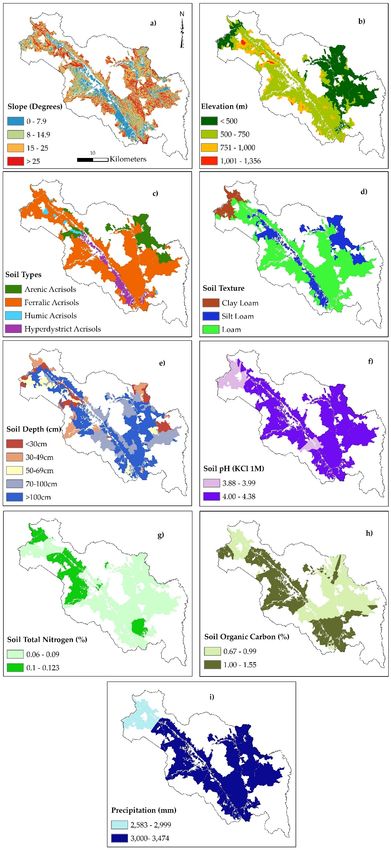
Land 2019, 8, 90                                                                                     2 of 25

when considering the physical as well as socio-economic factors [4]. On the regional scale, the active
participation of stakeholders can lead to a better and informed decision making process [5].
      Vietnam is an agricultural country in Southeast Asia that is characterized by population pressure
and land scarcity [6]. In 2016, 64% of the Vietnamese population resided in rural regions and 42% of
the total labor force worked in the agricultural sector [7]. Therefore, the effective management of land
resources for agricultural production in Vietnam is an essential requirement for food security and
sustainable rural development. Despite the area of agricultural land expanding from 22% in 2005 to
39% in 2016, the productivity and the value of agricultural production in Vietnam still remains lower
in comparison to other countries of the region, such as Thailand and China [7]. The inappropriate use
of agricultural land is a major constraint to agricultural production in Vietnam [8].
      Land evaluation is a process for predicting the land’s suitability for a specific land use type (LUT)
in a given area. Land evaluation provides a rational basis for land use planning [9], especially in
developing countries, where an increase of arable land, which is often limited by negative effects of
land degradation and environmental issues [10]. Distinct methods and models have been applied
for land evaluation, such as Linear Combination, Simple limitation, fuzzy-logic modelling, the use
of Artificial Neural Networks, and the Analytical Hierarchy Process (AHP) [11–16]. Despite some
limitations, the AHP is still the most commonly applied method for land evaluation, especially on a
small scale [17–19].
      Determining the requirements for a LUT and scoring the suitability level has significant impact
on land evaluation results [20]. The Food and Agriculture Organization of the United Nations
(FAO) (1996) [21] suggested that climate, soil, and landform are the necessary requirements for
land evaluation from an ecological perspective. Sys et al. (1993) [22] provided the reference values
for physical crop requirements for fifty crop types that are commonly cultivated in the tropical
and sub-tropical regions. These values have been applied by many researchers for land suitability
evaluation [23–27]. However, the crop requirements that were provided by Sys et al. (1993) [22] are
not detailed enough for smaller areas with specific characteristics.. Therefore, most of the researchers
modified the original crop requirements document to adapt to local conditions, experiences, and data
availability [28,29]. Local knowledge in land evaluation is very significant for land use decision-making
and land management in rural areas [30]. The integrated method of scientific and local knowledge
in land evaluation can lead to improved sustainable agricultural production [31]. A combination of
biophysical surveying, spatial modeling, and participatory methods are needed for effective land
evaluation, according to the FAO (2007) [20].
      Research on land evaluation requires a large amount of spatial data, which Geographical
Information Systems (GIS) are capable of easily and efficiently handling. Therefore, many researchers
have used GIS for land evaluation [32–34], a process, which enables the integration of multiple
attributes and different criteria that are involved in decision-making. Land evaluation can be seen as a
multi-criteria decision analysis (MCDA) process [35], which, when combined with GIS, can become a
powerful approach for land evaluation [34,36]. GIS techniques play an indispensable role in spatial
analysis, whereas MCDA provides a rich collection of tools for structuring decision problems, as well
as evaluating and prioritizing alternative decisions [34].
      This paper describes the integration of GIS and AHP methods that are based on scientific and
local knowledge to determine the land suitability for some potential agricultural LUTs in a hilly district
of Central Vietnam.

2. Materials and Methods

2.1. Reseach Area
     The study area “A Luoi district” is located between 107◦ E to 107◦ 300 E and 16◦ N to 16◦ 300 N
and it is situated around 60 km west of Hue city, in Central Vietnam (Figure 1). The climate at the
research site shows tropical monsoon characteristics with an annual rainy season from September to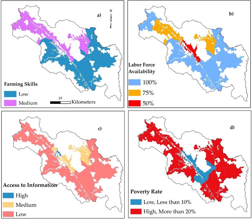
Land 2019, 8, 90 3 of 25
December.
Land 2019, 8, xThe
FORaverage
PEER yearly precipitation amounts to 3180 mm, according to statistics from 2005 3 of to
26
2015. The average temperature reaches its maximum in May and its minimum in January at 25 ◦ C and
17 ◦ C, respectively [37]. The research site exhibits a low mountainous topography, with elevations
and 17°C, respectively [37]. The research site exhibits a low mountainous topography, with elevations
ranging
ranging from
from 6060 mm to
to 1760
1760 m m above
above seasea level,
level, and
and decreasing
decreasing from
from west
west to
to east.
east. The slope in the area
is
is complex and steep, with an average of more than 20 degrees. According to
complex and steep, with an average of more than 20 degrees. According to the
the international
international soil
soil
classification
classificationsystem
system[38], there
[38], thereareare
fourfour
soil types withinwithin
soil types the research area, including
the research acrisols (ferralic)
area, including acrisols
(75%), acrisols
(ferralic) (75%),(arenic)
acrisols(14%),
(arenic)acrisols
(14%),(humic)
acrisols(6%), and (6%),
(humic) acrisols
and(hyperdystric) (5%) [39]. (5%) [39].
acrisols (hyperdystric)
A
A Luoi
Luoi district
district has an areaarea ofof 122,415
122,415 hectares
hectares (ha),
(ha), of which
which 60,105 ha (49%) are covered by
protected
protected forests,
forests, 57,492 ha (47%) are agricultural land (including (including production
production forests),
forests), 2,318
2318 ha (2%)
represent water bodies, and 2500 ha (2%) are residential and infrastructural
represent water bodies, and 2,500 ha (2%) are residential and infrastructural areas [40]. areas [40].
Four
Four ethnic minority groups are living in the research area, area, namely
namely the
the TaTa Oi, Co
Co Tu,
Tu, Van Kieu,
and
and PaPa Ko,
Ko, accounting
accounting for for 75%
75% of of the total population.
population. The majority Kinh people occupy occupy 25%.
25%. In 2015,
the total population was 47,115 inhabitants with 12,405
the total population was 47,115 inhabitants with 12,405 households. households. The households
households living below
living below the
the
poverty
poverty line
line occupied
occupied 37%37% ofof the
the total
total households.
households. The poverty
poverty line was defined
defined as as a monthly income
income
per
per person
person less
less than
than 2626 Euro
Euro [37].
[37].
Agricultural
Agricultural production
productionand and collection
collection ofof forest
forest products
products are
are the
the main
main livelihoods
livelihoods of the majority
of
of local
local people. Agricultural labor accounts for 75% of the entire labor force [37]. Acacia, Acacia, rice,
rice, rubber,
rubber,
cassava,
cassava, and banana are the five main agricultural
the five main agricultural crops. crops. In addition, there are a number
number of minor
of minor
crops,
crops, such
such asas corn,
corn, peanuts,
peanuts, and vegetables,
vegetables, which occupy a rather small area and do not not have
have aa
significant
significant impact on local local people’s
people’s livelihoods
livelihoods [37].[37]. The lack of basic resources, such such asas financing
financing
options
options andand modern
modern agricultural
agricultural knowledge, is one of of the
the main
main obstacles
obstacles toto sustainable
sustainable livelihood
livelihood
development,
development, especially
especially inin agricultural
agricultural cultivation
cultivation [14].
[14].
Figure 1. Research site and agricultural land use map.
Figure 1. Research site and agricultural land use map.
2.2. Material
2.2. Material
Input information plays an essential role for land evaluation. For each LUT, different values and
ranges of criteria
Input exist, defining
information plays anthe different
essential suitability
role for land levels. For the
evaluation. Forselection of criteria,
each LUT, differentthe available
values and
ranges of criteria exist, defining the different suitability levels. For the selection of criteria, the
available data, the cultivation history, and both local and worldwide knowledge need to be
considered [41]. The available datasets for land evaluation included geospatial as well as descriptive
Land 2019, 8, 90                                                                                        4 of 25

data, the cultivation history, and both local and worldwide knowledge need to be considered [41].
The available datasets for land evaluation included geospatial as well as descriptive information.
In total, six teen land characteristics were chosen as the input layers for the land evaluation process
listed in Table 1.

                                Table 1. List of data sets used in this study.

 Criteria                      Data Source                                       Map Method
 Physical Criteria
 Soil type                                                                       Convert from Mapinfo
                               Soil map of Thua Thien Hue province
 Soil depth                                                                      format (Tab) to ESRI
                               (1:100,000) issued by NIAPP in 2005 [39].
 Soil texture                                                                    format (Shp)
 Soil organic carbon
                                                                                 Ordinary kriging
 Soil total nitrogen           Soil survey data of 155 soil sampling [42].
                                                                                 (resolution at 30 m)
 Soil pH
 Elevation                     Digital Elevation Model (DEM), resolution at
                                                                                 Original data
 Slope                         30 m [43].
                               Average annual precipitation from 2005 to 2017
                                                                                 Inverse Distance Weighting
 Precipitation                 based on three meteorological station in Thua
                                                                                 (resolution at 30 m)
                               Thua Hue province [44].
 Economic Criteria
 Financial ability of family
 Accessibility of farming      Group discussion/Participatory GIS and
                                                                                 Community-wise
 equipment                     Statistical data [37]
 Labor income per day
 Ability to sell product
 Social Criteria
 Poverty rate
 Labor force availability      Individual discussion/ Participatory GIS
                                                                                 Community-wise
 Access to information         Statistical data [37]
 Farming skills

2.3. Methods

2.3.1. Participatory Rural Appraisal (PRA)
     The PRA method enables the capturing of opinions from farmers and other key actors in
agricultural and rural research [45]. In our study, the PRA method was used to select the potential
crops as well as the assessment of physical and socio-economic aspects in respect to land suitability
evaluation. The group discussion was implemented in eleven focus groups, with three to five people
per group. The groups consisted of members of the Agricultural Department of the commune or
district, the Natural Resources and Environment Department, the Labor and Social Affairs Department,
and the Industry and Commerce Department of A Luoi district. Additionally, members of the district
or commune committees, academics from Hue University, and farmers of the region participated in
the discussions. Moreover, individual interviews were conducted with soil scientists and agronomy
experts for the land evaluation regarding physical criteria (Table 2).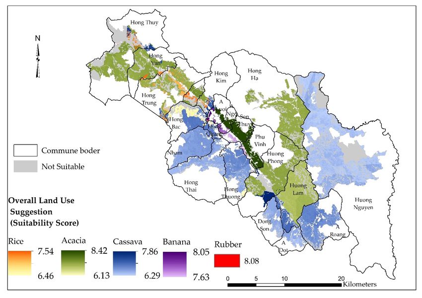
Land 2019, 8, 90                                                                                                                                                                                                                                                                            5 of 25

                         Table 2. Participants in Participatory Rural Appraisal (PRA) method.

          Participants from                                                                          Number of Participants
            Outside Experts                                                                                                                                         9
             Local Experts                                                                                                                                         21

                                                                                                      Online and Individual Discussion for Physical requirements
      District’s Agriculture and
                                                                          1                                                                                                                                          1
      Rural Development Dept.
           Hue University of

                                                                                                                                                                        Group Discussion for Economic requirements

                                                                                                                                                                                                                                             Individual Discussion for Social requirement
                                                                          1                                                                                                                                                          2                                                       1
       Agriculture and Forestry

                                   Group Discussion for Crops Selection
                District’s
                                                                          1                                                                                                                                          1
          People Committee
            Hue University
                                                                                                                                                                                                                                     2
              of Economy
        Natural Resources and
                                                                                 1                                                                                                                                   1
         Environment Dept.
         District’s Labor and
                                                                                 1                                                                                                                                                                                                           1
              Social Dept.
      District’s Commerce Dept.                                                  1                                                                                                                                   1
              Commune’s
                                                                                      1    1     1                                                                                                                   1   1   1   1
          People Committee
              Commune’s
                                                                                      1    1     1                                                                                                                       1   1   1
          Agricultural Dept.
                Farmers                                                               3    3     3                                                                                                                       3   3   3
       Agricultural Companies                                                                                                                                                                                                            1
             Small Traders                                                                                                                                                                                                               2
      Center Rural Development
                                                                                                                                                                                                                                                                                             1
          in Central Vietnam
            Farmer’s Union                                                                                                                                                                                                                                                                   1
                  Total            21                                     3      3    5    5     5    30                                                           30   27                                           5   5   5   5   4   3              4                                    4
                                                                              (Sources: Survey in year of 2017 & 2018).

2.3.2. Criteria Weighting According to Analytical Hierarchy Process (AHP)
     The AHP theory that was developed by Thomas L. Saaty (1987) [46] is a MCDA approach.
In scientific research on GIS-based land suitability evaluation, the approach is frequently applied for
criteria weighting [15,47–50]. The AHP is a method for deriving a priority scale through pairwise
comparison of attributes based on participant judgments [51]. The weighting of criteria through the
AHP method was implemented, as follows:

(1)     Selection of criteria and setting-up a hierarchy structure.

     The hierarchical structure is composed of three levels with the overarching goal of determining
the land suitability index for each LUT (Figure 2). The second and third levels show the criteria and
sub-criteria influencing the decision. Each sub-criteria has different attributes describing specific
characteristics, which have influence on the scoring algorithm for various LUTs. These characteristics
need to have substantial influence on the productivity, feasibility, or sustainability of the agricultural
land use [52]. In addition, critical values and a notable variation of criterion must be prevalent within
the study area [53]. The final set of sub-criteria were selected and categorized with reference to the
relevant literature [48,54–57], local expert knowledge, as well as local cropping guidelines that were
provided by Nguyen et al. (2015) [52].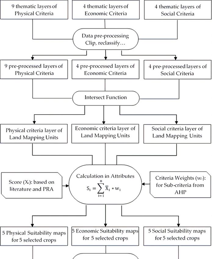
Land 2019, 8, 90                                                                                             6 of 25
   Land 2019, 8, x FOR PEER                                                                              6 of 26

                          Figure2.2.Hierarchical
                        Figure       HierarchicalStructure
                                                  Structure of
                                                            of the
                                                               the Land SuitabilityEvaluation.
                                                                   Land Suitability Evaluation.

(2) (2)Construction
          Construction of   pairwisecomparison
                         of pairwise    comparison      matrices
                                                    matrices      according
                                                              according        torelative
                                                                          to the   the relative importance
                                                                                          importance of eachof each
       criterion (or sub-criterion).
          criterion (or sub-criterion).
      The  The   comparison
             comparison        matrices
                           matrices   werewere   derived
                                            derived   from from   the experts’
                                                            the experts’ judgmentsjudgments   and constructed,
                                                                                      and constructed,          as
                                                                                                       as described
    described    by Mu   and Perevra-Rojas    (2017) [58]. A numerical  scale  that was  developed
by Mu and Perevra-Rojas (2017) [58]. A numerical scale that was developed by Saaty (2008) [51] was by Saaty (2008)
used[51]towas   used to
           compare      compare
                      these       these
                             criteria (orcriteria (or sub-criteria),
                                          sub-criteria),  as shownas inshown
                                                                        Table 3.in Table 3.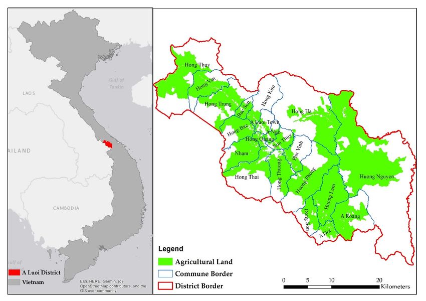
Land 2019, 8, 90 7 of 25
Table 3. Verbal and numeric scale for the pairwise comparison of criterion according to the Analytical
Hierarchy Process.
Numeric Scale Response Alternatives of Experts
9 Criterion i is extremely more important than criterion j
7 Criterion i is strongly more important than criterion j
5 Criterion i is more important than criterion j
3 Criterion i is slightly more important than criterion j
1 Criteria i is equally important as criterion j
1/3 Criterion i is slightly less important than criterion j
1/5 Criterion i is less important than criterion j
1/7 Criterion i is strongly less important than criterion j
1/9 Criterion i is extremely less important than criterion j
The geometric mean was applied to synthesize group judgments, as it represents the only
mathematically correct way to aggregate reciprocal judgments [59,60]. The Original Matrix (A), which
compares the priorities of all criteria against each other, was constructed.
1 C12 C1i C1 j C1n
C21 1 C2i C2 j C2n
A = Ci1 Ci2 1 Cij Cin
(1)
C j1 C j2 C ji 1 C jn
Cn1 Cn2 Cni Cnj 1
1
m
Y m
Cij = ( aijk ) (2)
k =1
where:
Cij is important level of criterion i as compared to criterion j
aijk is important level of criterion i as compared to criterion j according to expert kth
m is number of expert involves to discussion
Subsequently, the Normalized Matrix (B) is calculated from the A as Lee et al. (2012) [61].
c11 c12 c1i c1 j c1n
c21 c22 c2i c2 j c2n
B = ci1 ci2 cii cij cin
(3)
c j1 c j2 c ji c jj c jn
cn1 cn2 cni cnj cnn
Cij
Cij = Pn (4)
i=1 Cij
where:
Cij is normalized value of Cij
Pn
i=1 Cij is sum of Cij by column j from matrix A
n is number of compared criteria
From the matrix B, the criteria weights can be derived, as follows:
Pn
j=1 Cij
wi = (5)
n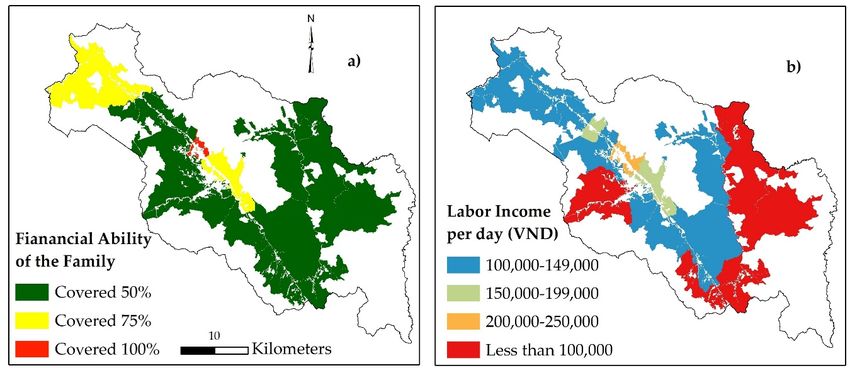
Land 2019, 8, 90 8 of 25
w1
w2
W = wi
(6)
wj
wn
where:
wi is the weight of criterion i
Pn
j=1 Cij is sum of Cij by row j from matrix B
(3) Validating the consistency of the final matrix of judgments.
A certain degree of inconsistency can be expected for criteria weightings based on group judgments.
The consistency ratio enables the validation of the participant’s answers by giving some indication on
the compatibility and rationality between compared criteria. The consistency ratio was calculated,
as suggested by Mu and Perevra-Rojas (2017) [58] and Saaty (1987) [46].
CI
CR = (7)
RI
where:
CR is Consistency Ratio
RI is Random Index has already been provides by Saaty (1987) [46] as Table 4.
Table 4. Random Index based on number of criteria.
n 1 2 3 4 5 6 7 8 9 10
RI 0 0 0.58 0.90 1.12 1.24 1.32 1.41 1.45 1.49
CI is Consistency Index (CI) is then obtained by calculating:
λmax − n
CI = (8)
n−1
Pn
P j=1 wi ∗Cij
w
λmax = i
(9)
n
According to Saaty (1987) [46], an inconsistency of 10% is acceptable. Hence, the weights of a
judgment matrix characterized by a CR ≤ 0.1 can be used for further analysis.
2.3.3. Deriving Scores for Criteria Levels
The level of each criterion ranges between the minimum and maximum values in the region,
which results in a distinct LUT performance, depending on the respective LUT. Therefore, the scores
need to be assigned indicating the suitability level of each attribute of each criterion for a given land
use type [9].
Many authors [55] refer to the land evaluation guidebook by Sys et al. (1993) [22], which
summarizes crop requirements for the tropics and sub-tropics. However, this guideline shows
significant shortcomings, as it does not provide information regarding some essential criteria (soil
total nitrogen, elevation, soil type), and additionally does not contain reference values for acacia
requirements. Moreover, no information on economic or social criteria are given by Sys et al. (1993) [22],
which are, for the growth of some crops, equally important as the physical characteristics of an area.
Due to these reasons, we introduced an attribute scoring based on the opinions of local stakeholders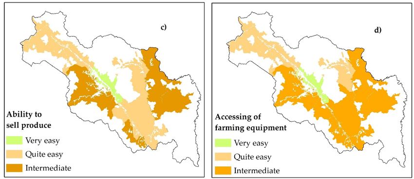
Land 2019, 8, 90                                                                                               9 of 25

that were gathered from the PRA survey, in addition to the common scoring approach that was derived
from Sys et al. (1993) [22]. We combined the scores according to Sys et al. (1993) [22], where possible,
with scores that were derived from the PRA survey and assigned a weight of 50% to each scoring
approach in the final suitability map. In those cases, in which the literature does not provide any
information, the PRA scores were fully applied for further analysis. A scale from three to nine was used
to reflect the increment from a very unsuitable condition to very suitability conditions for a particular
LUT (Table 5).

                                     Table 5. Scale for scoring according to PRA method.

                   Score (Xi )                                      Definition
                       9               Criterion is suitable for evaluated LUT without any concerns.
                       7                 Criterion is suitable for evaluated LUT with few concerns.
                       5             Criterion may be suitable for evaluated LUT with many concerns.
                       3                         Criterion is unsuitable for evaluated LUT.

2.3.4. Suitability Classification
     The suitability can be measured with the suitability index (Si ) (Table 6), which represents a function
of the weight and the score of each level of criterion regarding certain LUT. According to Huynh
(2008) [14], the suitability index for one land mapping unit (LMU) and one LUT is described, as follows:
                                                              n
                                                              X
                                                       Si =         X i ∗ wi                                     (10)
                                                              i=1
                                                              Qu
                                                                    v=1 Xiv
                                                       Xi =                                                      (11)
                                                                     u
where:

Si = suitability index for a particular LMU and LUT
Xi = Score of ith criterion

                                 Table 6. Scale for Suitability Index (Si ) for Land Evaluation.

      PRA            Literature                                                Definition
       8–9              S1(0)                   Suitability of LMU is high and satisfies all considered criteria.
       7–8              S1(1)           Suitability of LMU is high and satisfies most important considered criteria.
                                       Suitability of LMU is medium and satisfies most considered criteria, but some
       6–7                 S2
                                                                   criteria are not satisfied.
                                         Suitability of LMU is low and satisfies some considered criteria, but most
       5–6                 S3
                                                              considered criteria are not satisfied.
  Less than 5              N                                              Not Suitable

     As a result of the PRA survey, a threshold of 5.0, which is equivalent to the level N according to
Sys et al. (1993) [22], is used as a threshold for the areas that are unsuitable for the evaluated LUTs,
which will be excluded from further analysis in our research.

2.3.5. GIS Based Land Suitability Evaluation
     Seventeen thematic layers were created corresponding to the seventeen selected criteria for the land
evaluation process. These maps were classified based on the PRA survey and literature. Afterwards,
an intersection of all the layers was carried out to receive the land mapping units. The maps of land
mapping units form the basis for analyzing the physical, economic, and social suitability of each
land unit with respect to certain crop types. The calculation of suitability indices was performed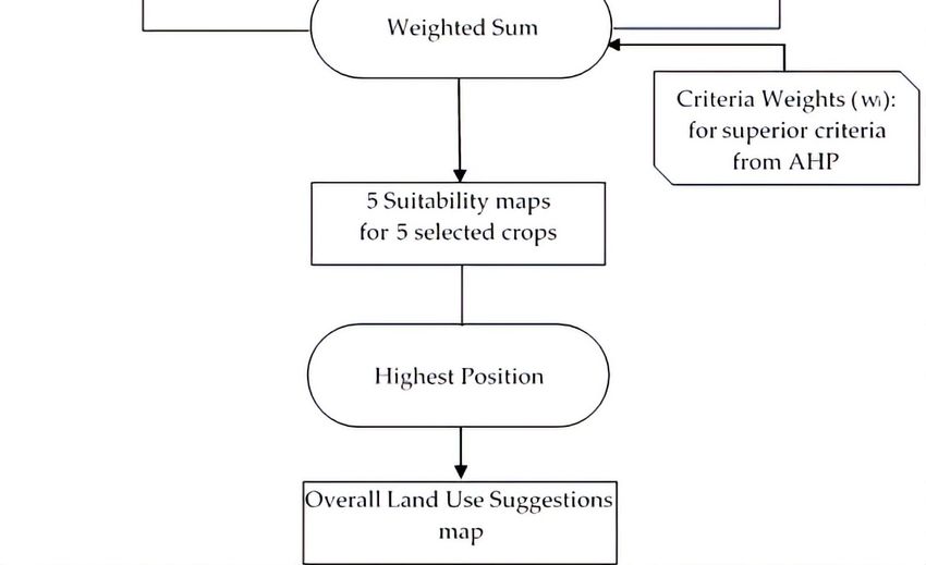
Land 2019, 8, 90                                                                                              10 of 25

using the attribute table of the vector layers, as suggested by Huynh (2008) [14]. The output of the
     Land 2019,
suitability     8, x FOR PEER
            mapping       will contain fifteen maps for all five crops showing their suitability with    10 respect
                                                                                                            of 26   to
the physical, economic, or social criteria. To receive the overall suitability, the three criteria-maps need
     with respect to the physical, economic, or social criteria. To receive the overall suitability, the three
to be overlaid for each crop. The weighted sum is used to create overall suitability maps for each crop.
     criteria-maps need to be overlaid for each crop. The weighted sum is used to create overall suitability
Frommaps
       the suitability
            for each crop.maps   of each
                              From        kind of crop,
                                    the suitability maps the  highest
                                                          of each  kindposition  toolhighest
                                                                        of crop, the  was applied
                                                                                             positiontotool
                                                                                                         analyze
                                                                                                             was the
mostapplied
      suitabletoland    usethe
                   analyze   formost
                                 a particular  landuse
                                     suitable land  unit
                                                       for(Figure  3). land unit (Figure 3).
                                                           a particular

                        Figure 3. Flow chart of GIS–based land evaluation methodology.
Land 2019, 8, 90 11 of 25
3. Results
3.1. Selected Crops for Land Suitability Evaluation
The group discussions led to the assumption that seven main crops are currently being cultivated
in A Luoi district: acacia (Acacia spp.), cassava (Manihot esculenta), rice (Oryza sativa), rubber
(Hevea brasiliensis), banana (Musa spp.), coffee (Coffea canephora), and different vegetables.
The pairwise comparison for the selection of land use type was conducted in-group discussions
with 25 participants from different backgrounds. The result (Table 7) indicates that acacia, cassava, rice,
rubber, and banana represent the most promising LUTs, and will hence be evaluated in this research.
Table 7. Final Ranking of Crops in A Luoi District for Land Suitability Evaluation derived from Pairwise
Comparison of Experts.
Physical Conditions Economic Conditions Social Conditions Total Final Rank
Acacia 0.136 0.172 0.045 0.353 1
Cassava 0.081 0.142 0.029 0.252 2
Rice 0.048 0.096 0.025 0.168 3
Rubber 0.032 0.043 0.008 0.084 4
Banana 0.027 0.036 0.007 0.070 5
Vegetables 0.016 0.021 0.006 0.044 6
Coffee 0.012 0.014 0.003 0.030 7
3.2. Characteristics of Physical, Economic and social LMUs
The LMUs map contained 987 land units for different physical, economic, and social criteria.
3.2.1. Layers of Physical Characteristics
There are nine physical characteristics layers present in Figure 4.
* Slope: 13,500 hectares of the total study area, mainly located in the center of the valley, show
moderate slope levels between 0 and 7.9 degrees. The slope level rises with increasing distance from
the valley and the highest slope levels of more than 25 degrees are found along the mountainsides in
the western part of the district.
* Elevation: The center of the valley and the eastern part of the district exhibit a low elevation level,
with approximately 2000 hectares underneath the elevation thresholds of 500 m. Nearly 30,000 hectares
of the studied area show elevation levels between 501 and 750 m. The remaining parts, especially in
the west, mostly exceed an elevation of 1000 m above sea level.
* Soil type: The acrisol only represents the prevalent reference soil group within the research area.
Acrisols (ferralic) cover the largest parts with 43,500 hectares and are scattered all over the district.
Acrisols (arenic) occupy the second largest area with a size of 8700 hectares in the central east of the
district. Acrisols (hyperdystric) can be exclusively found in the valley intersecting the district and
Acrisols (humic) exclusively occur in small patches, mainly in the north-west of the district.
* Soil texture: Pure loam occupies the largest extent with an overall area of around 40,400 hectares.
Clay loam is present on only 3500 hectares in the north and silt loam occupies 13,600 hectares in the
valley and in the eastern parts of the district.
* Soil depth: A soil depth of more than 100 cm is prevalent on nearly 30,000 hectares, followed by
a soil depth of 70–100 cm occupying about 15,000 hectares. Soil depths of less than 70 cm can be found
on only 25% of the evaluated area.
* Soil pH: The soil in the entire area can be referred to as acidic. The soil pH ranges from 3.9 to 4.4.
The soil pH of the central district is higher than in the remaining regions.Land 2019, 8, 90 12 of 25
Land 2019, 8, x FOR PEER 12 of 26
4. Geographic
FigureFigure 4. Geographicdistribution
distribution ofofphysical
physical criteria
criteria in Adistrict:
in A Luoi Luoi district: (a)elevation;
(a) slope; (b) slope; (b)(c) elevation;
soil
(c) soiltypes; (d)(d)
types; soilsoil
texture; (e) soil
texture; (e) depth;(f) pH value;
soil depth;(f) (g) soil (g)
pH value; totalsoil
nitrogen; (h) soil organic
total nitrogen; carbon;
(h) soil and,carbon;
organic
(i) annual
and, (i) annual precipitation.
precipitation.
* Soil total nitrogen: The soil total nitrogen contents in the region vary between 0.06 and 0.12 percent
of the soil weight. The lowest soil nitrogen levels can be found in the eastern region of the district, while
higher ones can be measured in the central west, in the valley, as well as in the southern part.Land 2019, 8, 90
Land 2019, 8, x FOR PEER 13 of 26 13 of 25
* Soil total nitrogen: The soil total nitrogen contents in the region vary between 0.06 and 0.12
* Soil organic
percent of the carbon: The
soil weight. Theaverage soilnitrogen
lowest soil organic carbon
levels can becontents
found in inthethe region
eastern range
region of thebetween
0.67 anddistrict,
1.55%while higher
of the soilones can be Similar
weight. measuredtoinsoil
the central west, in thecontents,
total nitrogen valley, as well
soil as in the southern
organic carbon shows
part.
the highest levels in the valley and in the southern part of the district, while the soil organic carbon
* Soil organic carbon: The average soil organic carbon contents in the region range between 0.67
contents in the eastern part remain low.
and 1.55% of the soil weight. Similar to soil total nitrogen contents, soil organic carbon shows the
* Precipitation:
highest levels in Due
theto the high
valley mountains
and in the southernin the
partwest,
of thethe precipitation
district, while thein A organic
soil Luoi district
carbonis rather
high, varying
contentsbetween 2500part
in the eastern mm and low.
remain 3500 mm. Rainfall levels reach their maximum in the center of
the district.* Precipitation: Due to the high mountains in the west, the precipitation in A Luoi district is
rather high, varying between 2500 mm and 3500 mm. Rainfall levels reach their maximum in the
center of
3.2.2. Layers ofthe district. Characteristics
Economic
There
3.2.2.are four of
Layers economic
Economiccharacteristic
Characteristics of economic layers as show in Figure 5.
* Financial ability of the family: This criterion
There are four economic characteristic referslayers
of economic to the
as financial ability
show in Figure 5. of the family to invest
in agricultural cultivation.
* Financial ability The
of thehouseholds in the center
family: This criterion of the
refers to thefinancial
districtability
are able to family
of the cover to
larger
investamounts
of financial requirements
in agricultural for cropping
cultivation. by their
The households own
in the means.
center of the district are able to cover larger amounts
of financial requirements for cropping by their own means.
5. Geographic
Figure Figure distribution
5. Geographic ofofeconomic
distribution criteriaininA A
economic criteria Luoi
Luoi district:
district: (a) financial
(a) financial ability ability
of the of the
family; family;
(b) labor(b)income
labor income
per day;per(c)
day; (c) ability
ability to sell to sell produce;
produce; and,
and, (d) (d) accessibility
accessibility of farming
of farming equipment.
equipment.
* Labor income per day: The criterion describes the daily average income of a farmer who spends
* Labor income per day: The criterion describes the daily average income of a farmer who spends
one day of work on the respective crop. The labor income per day plays an essential role in commercial
one day of work on the respective crop. The labor income per day plays an essential role in
LUTs, such as rubber, acacia, and banana. The income of people, who live in the communes that are
located in the center of the district and in the lower terrain area, is higher than the labor income of
other communes, as these offer other income opportunities. On average, their income amounts to
more than 150,000 VND per day. While the labor income in the north was estimated between 100,000
and 149,000 VND per day on average, in the mountainous communes along the southern and eastern
district border, labor income falls below the line of 100,000 VND.Land 2019, 8, x FOR PEER 14 of 26
commercial LUTs, such as rubber, acacia, and banana. The income of people, who live in the
Land 2019,communes
8, 90 that are located in the center of the district and in the lower terrain area, is higher than 14 of 25
the labor income of other communes, as these offer other income opportunities. On average, their
income amounts to more than 150,000 VND per day. While the labor income in the north was
* Ability to sell
estimated produce:
between The
100,000 andcommunes along
149,000 VND the on
per day main road in
average, (national road) cancommunes
the mountainous quite easily sell
their products. For the mountainous communes, located far away from the main roads,
along the southern and eastern district border, labor income falls below the line of 100,000 VND. as well as the
* Ability to sell produce: The communes along the main road (national
large rural commune of Huong Nguyen, the selling of produce is more challenging. road) can quite easily sell
* Accessibility of farming equipment: This criterion describes the ability of a farm the
their products. For the mountainous communes, located far away from the main roads, as well as family to
large rural commune of Huong Nguyen, the selling of produce is more challenging.
purchase farming equipment. Again, the communes located in favorable areas have better access to
* Accessibility of farming equipment: This criterion describes the ability of a farm family to
the inputs and agricultural machinery than other communes do.
purchase farming equipment. Again, the communes located in favorable areas have better access to
the inputs and agricultural machinery than other communes do.
3.2.3. Layers of Social Characteristics
3.2.3. Layers of Social Characteristics
There are four social characteristics layers present in Figure 6.
There
* Farming are four
skills: Onesocial characteristics
of the layers present
most challenging in Figure
issues 6.
of farmers in the A Luoi district is the level
* Farming skills: One of the most challenging issues of
of farming skills. Farming skills are vital, especially for agricultural farmers in theLUTs,
A Luoilike
district is theand
rubber levelbanana.
of farming skills. Farming skills are vital, especially for agricultural LUTs, like rubber and banana. In
In general, most local farmers practice agriculture based on their experiences.
general, most local farmers practice agriculture based on their experiences.
Figure 6.Figure 6. Geographic
Geographic distribution
distribution of social
of social criteriain
criteria in A
A Luoi
Luoidistrict: (a) (a)
district: level of faming
level skills; (b)
of faming labor
skills; (b) labor
force availability;
force availability; (c) access
(c) access to information;
to information; and,(d)
and, (d) poverty
poverty rate.
rate.
* Labor force availability: This criterion refers to the potential agricultural labor force that each
* Labor force availability: This criterion refers to the potential agricultural labor force that each
household in the commune can provide. The local people in the central area have other income
household in the commune can provide. The local people in the central area have other income
opportunities apart from agriculture, as already described in the context of labor income per day. As
opportunities apart from agriculture, as already described in the context of labor income per day.
As a result, the labor force that is available for agricultural production is lower than in rural and
mountainous communes.
* Access to information: The information regarding agricultural practices and technologies is
crucial for agricultural production, especially for commercial LUTs. According to the experts, only
the inhabitants of A Luoi Town, which is characterized by favorable infrastructural conditions, are,
on average, highly informed regarding new developments in the sector. Other communes in the valley
and around A Luoi Town, as well as Hong Ha commune, are assigned a medium level of information,
while the mountainous communes show a low level of information accessibility.Land 2019, 8, 90 15 of 25
* Poverty rate: The criterion estimates the share of commune’s inhabitants living below the
poverty line, which is defined at 700,000 VND per month. Around 37% of all households in the A Luoi
district live below the poverty line. A low poverty rate is assigned to the least rural communes, as A
Luoi Town and the adjacent communes in the valley. A high population living below the defined
poverty line characterizes the remaining regions.
3.3. Criteria Weights and Scores
The criteria weighting shows the differences in the importance level of each criterion
(or sub-criterion) on the different LUTs (Table 8). In general, the economic aspects play an essential role
in commercial LUTs, such as rubber, acacia, and banana. Hence, on the highest level of the hierarchy,
the overall economic criterion was assigned a considerably higher priority for the commercial crops
(all > 0.5) than for rice and cassava. As opposed to this, physical and social criteria seem to be more
critical for rice and cassava LUTs than the economic criteria. Moreover, each sub-criterion has a different
impact on the particular LUT. For example, with respect to physical conditions, soil quality criteria
generally have a stronger influence than terrain criteria. Regarding economic criteria, the commercial
agricultural LUTs (acacia, rubber, and banana) are mostly influenced by criteria that are associated
with the market.
Table 8. Weights of overall Criteria (bold number) and Sub-Criteria based on Analytical Hierarchy
Process (AHP).
(Sub-)Criterion/LUTs Rice Cassava Acacia Rubber Banana
Soil type 0.18 0.13 0.17 0.13 0.14
Slope 0.06 0.06 0.11 0.07 0.05
Soil Texture 0.15 0.07 0.08 0.08 0.10
Physical
Precipitation 0.14 0.06 0.05 0.05 0.04
Soil Organic Carbon 0.36 0.17 0.32 0.24 0.28 0.17 0.25 0.26 0.27 0.27
Soil Total Nitrogen 0.13 0.22 0.17 0.19 0.22
Soil pH 0.09 0.07 0.08 0.05 0.05
Elevation 0.04 0.05 0.06 0.05 0.05
Soil Depth 0.04 0.09 0.12 0.13 0.09
Labor income per day 0.18 0.33 0.24 0.18 0.13
Economic
Financial ability of the family 0.25 0.32 0.17 0.20 0.15
0.18 0.38 0.55 0.58 0.59
Accessibility of farming equipment 0.41 0.21 0.08 0.10 0.09
Ability to sell produce 0.16 0.13 0.51 0.51 0.62
Labor Force Availability 0.45 0.33 0.32 0.18 0.28
Social
Access to Information 0.20 0.17 0.23 0.19 0.15
0.47 0.30 0.17 0.18 0.14
Poverty rate 0.23 0.38 0.36 0.41 0.30
Farming skills 0.11 0.11 0.08 0.22 0.27
The scoring of the attribute of criteria (Table 9) is the assessment of the LUTs suitability with the
particular attribute of each sub-criteria related to physical, economic, and social conditions. Regarding
the criteria scoring, the attributes of all criteria were rated for each LUT with respect to the specific LUT
requirements. For physical criteria, the scoring was carried out based on the PRA surveys as well as on
literature that Sys et al. (1993) [22] provided. The result shows that the PRA scoring and literature
scoring approach show similarities, but differ in their magnitude. Concerning physical criteria, low
pH values, high levels of slope, as well as low soil fertility in the region are a limiting factor for all
kinds of agricultural land use. On the contrary, the main soil texture attributes and precipitation levels
are favorable regarding the majority of LUTs. With respect to economic criteria, low levels of economic
criteria are assigned for most commercial LUTs. Regarding the prevailing social conditions within the
study area, the differences between the commercial LUTs, except acacia, to the non-commercial LUTs
can be observed. A low level of farming skills and information access, as well as a high poverty rate,
in a more negative score for commercial crops. In general, the remaining LUTs are more resilient to
unfavorable social circumstances.Land 2019, 8, 90 16 of 25
Table 9. Scores based on PRA and Literature scoring approach.
PRA Scoring Literature Scoring
Criterion and Level Rice Cassava Acacia Rubber Banana Rice Cassava Rubber Banana
Soil depth (cm)
100 cm 7.00 5.00 7.61 8.08 8.45 8 8 7 8.5
Soil texture
Silt loam 6.50 7.30 7.61 7.52 7.30 8.5 7.5 7.5 8.5
Loam 7.33 6.85 7.20 6.83 7.94 7.5 7.5 7.5 7.5
Clay loam 6.14 4.79 6.17 5.78 7.45 8.5 7.5 8.5 8.5
Elevation (m)
1000 3.76 5.00 5.92 4.32 3.87
Slope (◦ )
0–7.9 8.20 9.00 6.80 8.38 8.45 7 7 7 7
8–14.9 4.72 7.00 8.63 7.26 7.45 5.5 5.5 5.5 5.5
15–25 3.58 5.72 7.61 5.47 4.66 3.5 4.5 4.5 4.5
>25 3.09 3.44 4.90 3.12 3.21 3.5 3.5 3.5 3.5
Soil total nitrogen (%)Land 2019, 8, 90 17 of 25
Table 9. Cont.
PRA Scoring Literature Scoring
Criterion and Level Rice Cassava Acacia Rubber Banana Rice Cassava Rubber Banana
Poverty rate
High (>20%) 5.92 5.44 5.44 3.41 3.41
No Information
Low (Land 2019, 8, 90 18 of 25
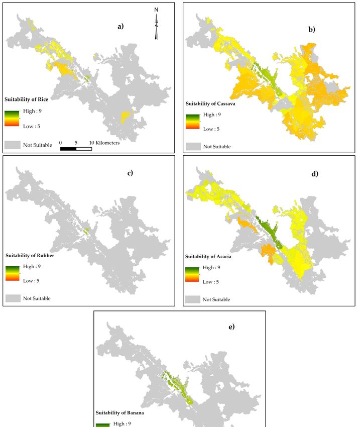
Son, Hong Trung, Hong Van, and Hong Thuy on of 1,388 hectares. The western, southern, and eastern
parts are most the suitable for cassava cultivation with a large area of 23,835 hectares. The suitable
areas for acacia account for 18,438 hectares, and they expand from the northern communes along the
valley towards the southern and eastern parts of A Luoi district. The area for rubber cultivation type
is small, with only five hectares in A Luoi Town. Small land units, summing up to the extent of 437
hectares in A Luoi Town and along the main road are suitable for banana LUT. Figure 7 presents the
suitability map
Land 2019, 8, xfor
FOReach
PEER kind of LUT and Figure 8 presents the overall land use map for entire
19 of district.
26
7. Land
FigureFigure suitability
7. Land forfor
suitability selected
selectedland
landuse
use types: (a)suitability
types: (a) suitabilityof of rice;
rice; (b) (b) suitability
suitability of cassava;
of cassava;
(c) suitability of (c)
rubber; (d) suitability of acacia, and, (e) suitability of banana.
suitability of rubber; (d) suitability of acacia, and, (e) suitability of banana.Land 2019, 8, x90FOR PEER 2019of
of 26
25
Figure 8. Overall land suitability of selected land use types for entire district.
Figure 8. Overall land suitability of selected land use types for entire district
4. Discussion
4. Discussion
4.1. Land Suitability Evaluation Methodology
4.1. Land Suitability Evaluation
The implemented methodology Methodology
of land suitability evaluation proved to be an appropriate and
useful approach for the application in a hilly district of Vietnam. In the Vietnamese uplands, social and
The implemented methodology of land suitability evaluation proved to be an appropriate and
economic characteristics have a significant impact on agricultural land use [62]. The MCDA procedure
useful approach for the application in a hilly district of Vietnam. In the Vietnamese uplands, social
allowed for the integration of physical, economic, and social criteria, as well as the involvement of local
and economic characteristics have a significant impact on agricultural land use [62]. The MCDA
experts’ judgments. However, these judgments can be highly variable in space and time, which thus
procedure allowed for the integration of physical, economic, and social criteria, as well as the
leads to a trade-off between local knowledge involvement and objectivity. Moreover, it has limitations
involvement of local experts’ judgments. However, these judgments can be highly variable in space
of independence among criteria [63]. Zolekar & Bhagat (2015) [57] make use of correlation analysis to
and time, which thus leads to a trade-off between local knowledge involvement and objectivity.
demarcate the most determining criteria for agricultural land use and to eliminate the interdependent
Moreover, it has limitations of independence among criteria [63]. Zolekar & Bhagat (2015) [57] make
ones, which would have been an adequate option to improve the data base.
use of correlation analysis to demarcate the most determining criteria for agricultural land use and
The use of a Geographic Information System proved to be highly useful in the context of land
to eliminate the interdependent ones, which would have been an adequate option to improve the
suitability evaluation, as it facilitates the geographic assignment of criteria to land units. For physical
data base.
criteria, random sampling and interpolation proved to be an adequate approach to represent the
The use of a Geographic Information System proved to be highly useful in the context of land
physical conditions in the area [42]. However, the Boolean approach still has limitations on the ability to
suitability evaluation, as it facilitates the geographic assignment of criteria to land units. For physical
express the transitional or continuous variation in geographical features [64]. To reduce this limitation,
criteria, random sampling and interpolation proved to be an adequate approach to represent the
Fuzzy set theory [65] with partial membership function could be used as an appropriate solution [66,67].
physical conditions in the area [42]. However, the Boolean approach still has limitations on the ability
With regard to the economic and social criteria, it must be noted that the community-wise assignment
to express the transitional or continuous variation in geographical features [64]. To reduce this
of characteristics leads to oversimplification, as socio-economic traits can differ considerably, even
limitation, Fuzzy set theory [65] with partial membership function could be used as an appropriate
within communities. For a small-scale and more appropriate observation, a household survey on
solution [66,67]. With regard to the economic and social criteria, it must be noted that the community-
socio-economic factors regarding agricultural land use practices would be required. However, as stated
wise assignment of characteristics leads to oversimplification, as socio-economic traits can differ
by Yen et al. (2013) [62], a more complex approach to land suitability evaluation requires high quality
considerably, even within communities. For a small-scale and more appropriate observation, a
data and sufficient resources to acquire such data.
household survey on socio-economic factors regarding agricultural land use practices would be
This study indicates that the exclusive procurement of scoring values from Sys et al. (1993) [22]
required. However, as stated by Yen et al. (2013) [62], a more complex approach to land suitability
cannot draw a holistic picture of the local conditions. The land suitability evaluation that is based
evaluation requires high quality data and sufficient resources to acquire such data.Land 2019, 8, 90 20 of 25
on the PRA survey differed considerably from this approach, particularly in the evaluation of the
commercial crops rubber and banana. According to the guideline of Sys et al. (1993) [22], most
agricultural land of A Luoi district would be unsuitable for crop production, due to soil being very
acidic and the steep terrain. However, very diverse agricultural land use is taking place in the research
area. This finding leads to the conclusion that site-specific knowledge regarding local characteristics
cannot be captured by universally applicable literature. Therefore, this study suggests the integration
of scientifically grounded literature on crop requirements and local knowledge in the form of a scoring
through PRA methods.
4.2. Limiting Factors for Agricultural Production
Many environmental, economic, and social conditions of A Luoi district are unfavorable for
agricultural production. Physical criteria, such as steep terrain, soil acidity, and low soil nitrogen
are the main restrictions for agricultural cultivation, especially for commercial crops, like rubber and
banana. Serious erosion rates, population pressure, and fallow cultivation have an additional negative
effect on sustainable cultivation [68,69].
Unfavorable economic conditions are mainly prevalent in the remote areas of the study area due
to infrastructural and physical limitations [70], which particularly affect the production of commercial
crops. An essential requirement for this kind of land use is the long-term financial ability. This requires
significant investments during the early period of crop production, with expected benefits at a later
stage [71]. In the last years of the life span, the productivity and quality of agricultural products will
significantly reduce, leading to economic risks for the local people [72]. Hence, from an economic
viewpoint, the accessible and central municipalities are the most suitable for agricultural land use.
The evaluated crops are most suitable in the lowland where lowest poverty rates, sufficient access
to information, and a higher level of farming skills are prevalent. These social conditions are vital
for the production of rubber and banana. For instance, the plantation of rubber trees, the harvest
of latex, and the manufacturing of a transportable rubber product demands a considerable degree
of technological knowledge [73,74]. In comparison to cassava and upland rice, the knowledge base
among farmers regarding new commercial crops is still limited [72].
4.3. Future Perspective on Agriculture in A Luoi district
Significant changes in investment, household income, and policies have occurred in the Vietnamese
agricultural sector within the last decades [75–77]. Traditional agricultural practices are gradually
replaced by rather market-oriented food and commodity production [68]. However, agricultural
production in Vietnam still faces many serious challenges, such as marker price volatility, financial
resources, and farming skills [78]. These difficulties are more serious in the upland regions, where
ethnic people groups occupy the majority of population [62].
In the following, the land evaluation results will be discussed in respect to the 2030 land
use development plan for A Luoi district [79]. Crop diversification is found to stabilize incomes
and enhance resilience [80]. A mixed agricultural land use planning involving commercial and
non-commercial crops is a promising land use scheme for A Luoi district. Rubber, banana, and rice
should exclusively be cultivated in the flat land, while acacia and cassava should expand in the rural
area and remote communes.
According to the land use planning of A Luoi district, rice expansion is planned on 2300 to 2500
hectares in all communes, specifically in Huong Phong, Hong Ha, and Huong Nguyen. Nonetheless,
rice cultivation will not be possible in these areas without the implementation of appropriate coping
strategies that are aimed at an enhanced level of soil nitrogen and carbon. An expansion of rice fields
towards Hong Bac and Hong Trung, represents an optional strategy.
Acacia is an exceptional commercial land use type, for which the expanded area of cultivation
is encouraged and social acceptance is high. The expansion will especially be carried out on bared
lands, which is in line with the outcomes of the land suitability evaluation. However, the intendedLand 2019, 8, 90 21 of 25
conversion of current coffee zones to acacia plantations might be challenging, as this region is not
suitable for any of the evaluated land use types.
Cassava, similarly to acacia, can flexibly be planted within many communes, even in remote areas.
Intercropping could be applied for this kind of land use as well as acacia to supply the many food
factories in Hue and Da Nang city. It also helps local farmers increase income and saving investments
through the reduction of fertilizers.
Regarding banana, the district has a plan to expand up to 200 to 250 hectares in some communes
in the northern part of the district and A Luoi Town. Potential banana planting in A Luoi commune
is possible based on the performed land suitability evaluation. Communes that are designated for
banana production in the future land use plan are less suitable when compared to the central valley
communes of A Ngo, Son Thuy, and Phu Vinh.
Concerning rubber production, the future-zoning plan for A Luoi district intends to expand the
rubber plantations on 1000 to 1500 hectares in Phu Vinh and Son Thuy communes and to maintain
current rubber plantations. The findings of the land suitability evaluation suggest rubber expansion
within Son Thuy commune, even though this area seems more suitable for acacia. Phu Vinh commune
had been evaluated as being unsuitable for rubber production, which is not the case when considering
the performed suitability evaluation. The current rubber plantation zones (in Hong Ha, Nham
commune) are unsuitable for rubber products according to the land suitability evaluation. This fact is
in line with statements of locals during group discussions who mention that scattered rubber trees
are only planted in these areas as a consequence of rubber subsidization programs, and are hence not
sustainable on a long-term basis.
5. Conclusions
This research is the first GIS-based multi-criteria land suitability evaluation based on physical,
economic, and social conditions, conducted in a hilly district of Central Vietnam. It provides a
framework for land evaluation relevant to stakeholders in the district level of Vietnam. Moreover, land
suitability evaluation can function as a vital planning tool to rationally assess sustainable agricultural
practices for a region and enable the prevention of a trial and error process in agricultural land use
planning. Therefore, land suitability evaluation should be a mandatory step before implementing any
specific land use, especially in the agricultural sector.
In the frame of this research, it became apparent that future land use practices envisaged by
planning authorities do not always coincide with the expectation of land user, scientists, and even
different departments in the government system. The promotion of commercial crops, like rubber and
banana in A Luoi district, needs careful consideration as major constraints, especially on the economic
level prevail within the research area.
Author Contributions: Conceptualization, R.H., T.G.P. and M.K.; methodology, R.H., T.G.P. and D.W.; software,
R.H. and T.G.P.; validation, R.H. and T.G.P.; formal analysis, R.H., T.G.P. and C.T.M.T.; investigation, T.G.P. and
C.T.M.T.; resources, T.G.P. and C.T.M.T.; data curation, T.G.P. and C.T.M.T.; writing—original draft preparation,
R.H., T.G.P. and D.W.; writing—review and editing, R.H., T.G.P., M.K. and D.W.; visualization, R.H and T.G.P.;
supervision, M.K.
Funding: This research was funded by the Ministry of Education and Training of Vietnam via providing scholarship
for the corresponding author to study Ph.D degrees at Göttingen University, grant number DA-911. The APC was
funded by the Open Access Publication Fund of the University of Göttingen, Germany.
Acknowledgments: The authors thank the Vietnamese government for their financial support. This publication
was supported financially by the Open Access Publication Fund of the University of Göttingen, Germany. We also
thank the anonymous reviewers for their valuable comments, which greatly improved our paper.
Conflicts of Interest: The authors declare no conflict of interest.Land 2019, 8, 90 22 of 25
References
1. United Nations, Department of Economic and Social Affairs, Population Division. World Population Prospects:
The 2017 Revision. Key Findings and Advance Tables; United Nations, Department of Economic and Social
Affairs, Population Division: New York, NY, USA, 2017.
2. Food and Agriculture Organization of the United Nations. The State of the World’s Land and Water Resources
for Food and Agriculture. Managing Systems at Risk; Food and Agriculture Organization of the United Nations
and Earthscan: Abingdon, UK, 2011; ISBN 978-1-84971-326-9.
3. United Nations, Department for Economic and Social. Sustainable Development Goals Report 2017; United
Nations, Department for Economic and Social: New York, NY, USA, 2017; ISBN 978-92-1-101368-9.
4. Keesstra, S.; Mol, G.; de Leeuw, J.; Okx, J.; Molenaar, C.; de Cleen, M.; Visser, S. Soil-Related Sustainable
Development Goals: Four Concepts to Make Land Degradation Neutrality and Restoration Work. Land 2018,
7, 133. [CrossRef]
5. Kapović Solomun, M.; Barger, N.; Cerda, A.; Keesstra, S.; Marković, M. Assessing land condition as a first
step to achieving land degradation neutrality: A case study of the Republic of Srpska. Environ. Sci. Policy
2018, 90, 19–27. [CrossRef]
6. Ministry of Natural Resources and Environment of Vietnam. The Second Biennial Updated Report of Vietnam to
the United Nations Framework Convention on Climate Change; Vietnam Publishing House of Natural Resources,
Environment and Cartography: Ha Noi, Vietnam, 2017; ISBN 978-604-952-187-4.
7. Food and Agriculture Organization of the United Nations. World Food and Agriculture. Statistical Pocketbook
2018; FAO: Rome, Italy, 2018; ISBN 978-92-5-131012-0.
8. Quang, C.T.; Chung, T.K. Agricultural Land Policy in the Process of Agriculture & Rural Industrialization and
Modernization in Vietnam. 2005. Available online: http://www.chinareform.org/publications/reports/200504/
t20050416_111326.htm (accessed on 15 December 2018).
9. de la Rosa, D.; van Diepen, C.A. Land Use, Land Cover and Soil Sciences. Qualitative and Quantitative Land
Evaluations (Agro-Ecological Land Evaluation); Encyclopedia of Life Support Cultural Organization: Oxford,
UK, 2002.
10. Verheye, W.H. Land Use, Land Cover and Soil Sciences. Land Evaluation; Eolss Publishers Co. Ltd.: Oxford, UK,
2009; ISBN 184826691X.
11. Ali Asghar, J.; Parisa, A.; Mohamed Reza, N.; Siamak, S. Land Suitability Evaluation of Bilverdy Research
Station for Wheat, Barley, Alfalfa, Maize and Safflower. Soil Water Res. 2008, 3, 81–88.
12. Orhan, D.; Mustafa, U. Multi-criteria approach with linear combination technique and analytical hierarchy
process in land evaluation studies. Eurasian J. Soil Sci. 2018, 7, 20–29.
13. Orhan, D.; Ceyhun, G.; Fatma Esra, S.; Semih, E. Parametric approach to land evaluation for forest plantation:
A methodological study using GIS model. Afr. J. Agric. Res. 2010, 5, 1482–1496. [CrossRef]
14. van Huynh, C. Multi-Criteria Land Suitability Evaluation for Selected Fruit Crops in Hilly Region of Central
Vietnam. With Case Studies in Thua Thien Hue Province; Shaker: Aachen, Germany, 2008; ISBN 3832268464.
15. Ayla, B.; Fadim, Y.; Aslı, D. AHP and GIS based land suitability analysis for Cihanbeyli (Turkey) County.
Environ. Earth Sci. 2016, 75, 813–823. [CrossRef]
16. Alilou, H.; Rahmati, O.; Singh, V.P.; Choubin, B.; Pradhan, B.; Keesstra, S.; Ghiasi, S.S.; Sadeghi, S.H. Evaluation
of watershed health using Fuzzy-ANP approach considering geo-environmental and topo-hydrological
criteria. J. Environ. Manag. 2019, 232, 22–36. [CrossRef] [PubMed]
17. Nguyen, H.H. Evaluation of Coastal Sandy Land in Thanh Hoa province for Agricultural Development with
Case study of Quang Xuong district. Ph.D. Thesis, Faculty of Mathematics and Natural Sciences, Greifswald,
Germany, 2017.
18. Tran, D.T. Using GIS and AHP Technique for Land Use Suitability Analysis. In Proceedings of the
International Symposium on Geoinformatics for Spatial Infrastructure Development in Earth and Allied
Sciences, Ho Chi Minh City, Vietnam, 9–11 November 2006.
19. Liaghat, M.; Himan, S.; Bashir Rokni, D.; Farshid Sattari, A.; Seyed Navid, S.; Hadi, B. A Multi-Criteria
Evaluation using the Analytic Hierarchy Process Technique to Analyze Coastal Tourism Sites. APCBEE
Procedia 2013, 5, 479–785. [CrossRef]
20. Food and Agriculture Organization of the United Nations. Land Evaluation. Towards a Revised Framework;
FAO: Rome, Italy, 2007.You can also read