Napoleon Project - January 2021 - Henry Slaughter
←
→
Page content transcription
If your browser does not render page correctly, please read the page content below
Napoleon Project – January 2021
Disclaimer and Qualified Person
 Forward Looking Statements

 •   This document includes certain statements that constitute “forward-looking statements” and “forward-looking information” within the meaning
     of applicable securities laws (collectively, “forward-looking statements”). Forward-looking statements include statements regarding Kenorland
     Minerals Ltd. (“Kenorland”) intent, or the beliefs or current expectations of Kenorland’s officers and directors. Such forward-looking statements
     are typically identified by words such as “believe”, “anticipate”, “estimate”, “project”, “intend”, “expect”, “may”, “will”, “plan”, “should”, “would”,
     “contemplate”, “possible”, “attempts”, “seeks” and similar expressions. Forward-looking statements may relate to future outlook and anticipated
     events or results.

 •   By their very nature, forward-looking statements involve numerous assumptions, inherent risks and uncertainties, both general and specific, and
     the risk that predictions and other forward-looking statements will not prove to be accurate. Do not unduly rely on forward-looking statements,
     as a number of important factors, many of which are beyond Kenorland’s control, could cause actual results to differ materially from the
     estimates and intentions expressed in such forward-looking statements.

 •   Forward-looking statements speak only as of the date those statements are made. Except as required by applicable law, Kenorland does not
     assume any obligation to update, or to publicly announce the results of any change to, any forward-looking statement contained herein to reflect
     actual results, future events or developments, changes in assumptions or changes in other factors affecting the forward-looking statements.

 Qualified Person’s Statement

 •   Janek Wozniewski, P.Geo., OGQ, Exploration Manager for Kenorland, is the Qualified Person as defined by National Instrument 43-101,
     Standards of Disclosure for Mineral Projects. Mr. Wozniewski is responsible for the scientific and technical data presented herein and has
     reviewed and approved this project summary. Of note, historical results reported herein have not been verified by Kenorland personnel. Surface
     grab samples are selective by nature and are unlikely to represent average grades of the mineralization found on the property.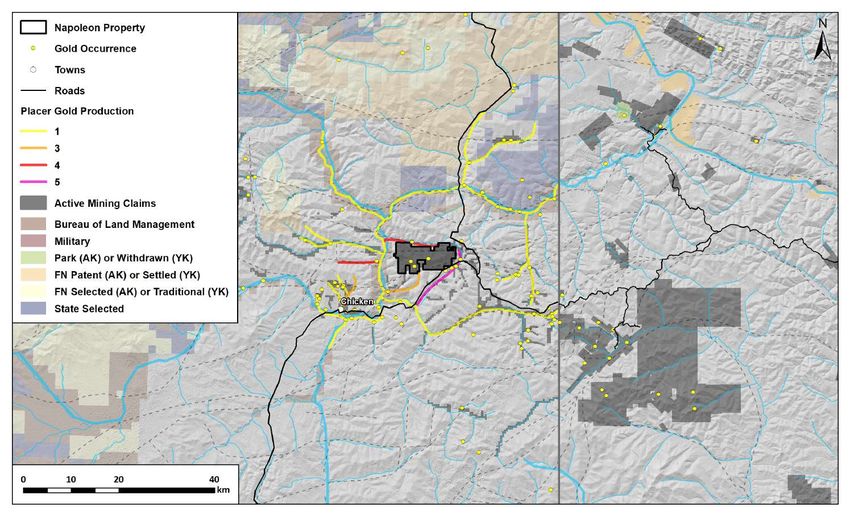
The Napoleon Project
                                                 •   The Napoleon Project covers 6,056

                                        CANADA
                                                     hectares of state-owned Alaska

                                  USA
                                                     mining claims

                       Napoleon Project          •   The property is located within the
                                                     prolific Tintina Gold Province; host of
                                                     significant gold deposits such as
                                                     Donlin Creek, Fort Knox, Pogo,
                                                     Coffee, Scheelite Dome and Dublin
                                                     Gulch

                                                 •   The Tintina Gold province has had
                                                     past production of over 30 million
                                                     ounces and current estimated
                                                     resources of over 39 million ounces
                                                     of gold

                                                                                           3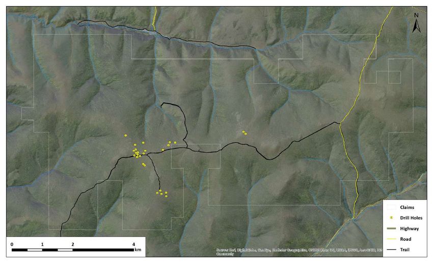
Sources of Placer Gold
                                                 Placer Au              Documented Lode Au                   Documented Lode Au
                                                                                                                                                                           •   The Napoleon Project is located
      Gold Camp                                                                                                                                 Total Documented Lode Au       within the historical Fortymile placer
                                                Production2                 Production                           Resources*
                                                                                                                                                                               gold camp
      Klondike River, Indian
      River and Lower Stewart                      10,017,936                                                                  8,731,000                       8,731,000

                                                                                                                                                                           •   Exploration of historical placer
      Caribou                                          682,879                          1,288,096                              4,421,135                       5,709,231
                                                                                                                                                                               districts throughout Alaska, BC and
                                                                                                                                                                               the Yukon have resulted in numerous
      Mayo, Clear Creek                                619,453                                                                 7,623,234                       7,623,234       hard rock gold discoveries

      Fortymile                                        500,000                                                                                        No Known Lode Au

                                                                                                                                                                           •   There are no documented lode gold
      Quesnel                                          437,586                            117,017                              6,401,671                       6,518,688       resources or hard rock gold
                                                                                                                                                                               production in the Fortymile despite
      Juneau Belt                                      120,000                          9,444,099                              8,690,090                      18,134,189       it’s rich placer gold occurrences

      Bridge River                                     109,443                          4,203,464                                720,947                       4,924,411
                                                                                                                                                                           •   Napoleon is the most significant hard
      Cassiar                                          108,000                            327,925                              1,361,213                       1,689,138       rock gold system within the region

*numbers are taken from publicly available measured indicated and inferred resources

2
Pre 1940 Placer production numbers are not readily available before 1940. An estimate was made for early production from post 1940 production

                                                                                                                                                                                                                     4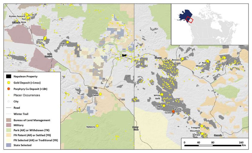
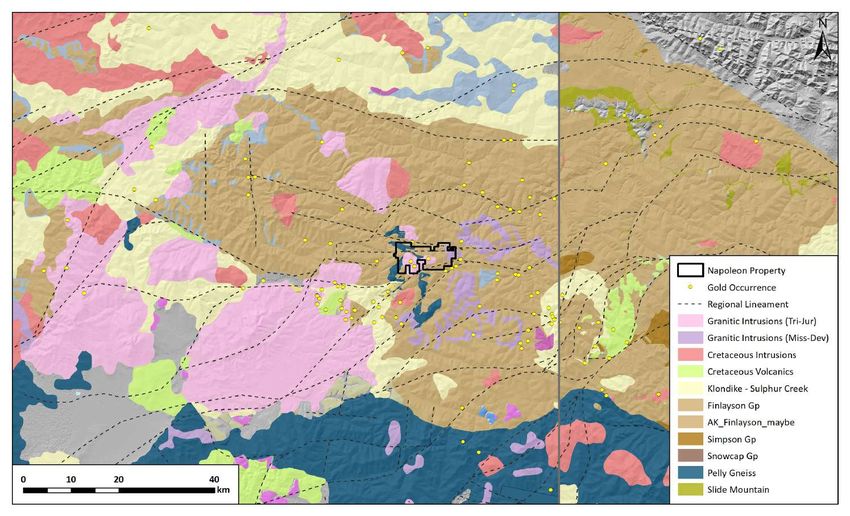
Regional Geology
                                                                                  •   The project is located in the Yukon-

                                                                         CANADA
                                                                                      Tanana terrane (YTT), a region of

                                                                   USA
                                                                                      metamorphic rocks of Upper
                                                                                      Paleozoic and older ages that were
                                                                                      deposited or emplaced near the edge
                                                                                      of the North American continental
                          General extent of the Fortymile Mining District             margin and

                                                                                  •   The YTT was then intruded by
                                                                                      multiple phases of granitoid igneous
                                                                                      rocks during the Mesozoic and
       Napoleon Project                                                               Cenozoic

                                                                                  •   The terrane is bound in the northeast
                                                                                      by the Tintina Fault and in the
                                                                                      Southwest by the Denali Fault

                                                                                  •   The more local geology of the
                                                                                      Fortymile district is defined by a
                                                                                      series of major east-west trending
                                                                                      faults, and Jurassic aged plutons
                                                                                      intruded into the metamorphic rocks
                                                                                      or the Klondike assemblage

                                                                                                                             5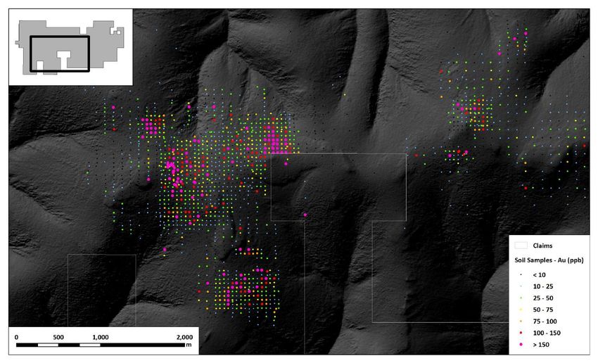
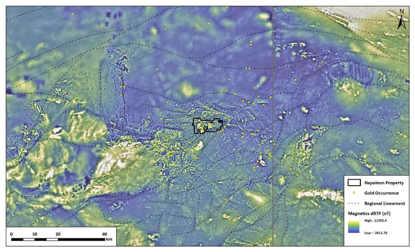
Regional Magnetics
                                                                                  •   Regional airborne magnetic surveys

                                                                         CANADA
                                                                                      completed by the Alaska Division of

                                                                   USA
                                                                                      Geological and Geophysical Surveys

                                                                                  •   Magnetics show the structural
                          General extent of the Fortymile Mining District
                                                                                      complexity (regional folding and
                                                                                      faulting) within the Fortymile mining
                                                                                      district

       Napoleon Project
                                                                                  •   Magnetic lows delineate a series of
                                                                                      major east-west trending faults and
                                                                                      cross cutting NE-SW trending faults

                                                                                  •   The Napoleon pluton and other large
                                                                                      intrusive bodies are expressed as a
                                                                                      magnetic highs

                                                                                                                            6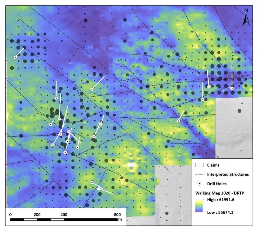
The Fortymile Placer District
                                                             •   The Forty Mile Placer district is

                                      CANADA
                                                                 located between Dawson City, Yukon

                                USA
                                                                 and Tok, Alaska along the ”Top of the
                                                                 World” Highway

                                                             •   The district was the first major gold
                                                                 find in Alaska and has has been
                                                                 actively mined since its discovery In
                                               Dawson City
                                               (20 Miles)
                                                                 1886

                                                             •   An estimated 500,000 ounces of gold
                                                                 of have been produced from river
                                                                 gravels in the district

                                                             •   The Napoleon Project is located at
                                                                 the headwaters of three of main gold
               Tok
                                                                 bearing creeks in the district
               (60 Miles)                                        (Napoleon, Wade, and Uhler)

                                                                                                         7
The Napoleon Property Roads and Infrastructure
                                                                                                         •   The Napoleon Project is located 35
                                                                              Eagle
                                                                              (100 km)                       km from the town of Chicken, Alaska,
                           UHLER CREE
                                     K                                                                       and 100 km from Tok, Alaska along
      Uhler Creek Active                                                                                     the Taylor Highway
         Placer Mine

                                                                                                         •   Tok is the main supply hub however
                                                                                                             Chicken can provide gasoline, food,
                                                                                                             and lodging as well as a a fully
                                                                                                             operational camp to house an
                                                                                                             exploration crew

                                                                                                         •   A network of historical drilling roads
                                                                                                             and hunting trails cross the property.
                                                                                           Dawson City
                                                                                           (140 km)          These can be easily upgraded to
                                                                                                             service a drilling program
                                                          Wade Creek
                                          CR LEON

                                                                                       K
                                                          Active Placer              EE
                                            EEK

                                                                                  CR
                                            PO

                                                              Mine              E
                                                                              AD
                                         NA

                                                                          W
                                                                                                         •   Roads were originally developed to
                                         Napoleon Creek
                                          Active Placer         Chicken
                                                                                                             service drill pads during the last
                                           Mine (2km)           (35 km)                                      drilling campaigns from 1999-2001

                                                                                                                                                   8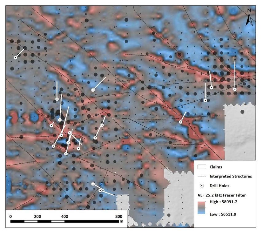
The Napoleon Property Geology
                                                                            •   Gold mineralization is controlled by
                                                                                east-west and northwest and north-
                                                                                northeast trending shear zones
                                                                                within the Napoleon pluton,
                                                                                commonly kaolinite-quartz-
                      COUNTRY ROCK OF PREDOMINATELY KLONDIKE                    carbonate altered
                                 SCHIST AND GNEISS

                     Saddle Zone
                                                                            •   High-grade gold is associated with
                                                                                quartz-pyrite veins, with K-feldspar-
                                                               Twin Peaks
                                                                                sericite-pyrite altered selvedges.

   Main Zone
                                                                            •   From 1999 to 2001 27 holes were
                                                                                drilled into 5 prospective target areas
    Trench 24 Area                                                              identified by soil sampling and
                                                                                surface mapping: The Main Zone,
                                                                                Trench 24 Zone, Saddle Zone, Burnt
                                   Burnt Ridge                                  Ridge Zone and Twin Peak Zone

                      COUNTRY ROCK OF PREDOMINATELY KLONDIKE
                                 SCHIST AND GNEISS

                                                                                                                        9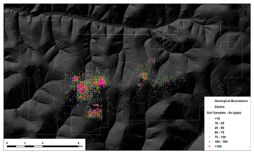
Notable Drilling Results
Year              Drill Type            Drill Hole          From (m)   To (m)   Width (m)   Gold (g/t)   A total of 4759 meters over 27 holes were
                                                                                                         drilled by Kennecott and Teck resources.
                                        NAP 3                15.24     15.85      0.61        16.3
                                                                                                         Average hole depth was 50.6 m
                                        NAP 3                27.43     28.96      1.53         2.0

                                        NAP 3                35.05     35.66      0.61        38.3
                                                                                                         Highlighted results from these drill
                  Diamond Core          NAP 3                39.62     41.15      1.53         1.1
                                                                                                         programs include:
 1999                                   NAP 4                12.98     14.63      1.65         3.9
 Kennecott
                                        NAP 4               110.03     110.64     0.61         5.6
                                                                                                         •   74m of 0.9 g/t Au Including 0.9m of
                                        NAP 5                21.18     21.95      0.77         7.0
                                                                                                             23 g/t Au (NP-10)
                                        NRC 3                12.19     13.72      1.53         3.6

                  Reverse Circulation   NRC 4                 9.14     18.29      9.15         1.8
                                                                                                         •   0.6m of 38.0 g/t Au (NAP 3)
                                        NRC 7                30.48     33.53      3.05         1.9

                                        NP-10                47.60     121.60     74.0         0.9

                                                Including    53.40     54.30      0.90        22.7       •   9.2m of 1.8 g/t Au (NRC4)
 2001
 Teck Resources   Diamond Core          NP 1                 71.50     72.50      1.00         4.7

                                        NP 2                144.00     147.00     3.00         8.9
                                                                                                         •   3.0m of 8.9 g/t Au (NP 2)
                                        NP 3                156.00     21.30      1.20         8.2

                                                                                                                                                10
Gold Mineralisation
A. Fault Brecciated Monzonite
• Gold mineralization is controlled by
east-west and northwest and north-
northeast trending shear zones
within the Napoleon pluton,
commonly kaolinite-quartz-
carbonate altered
• High-grade gold is associated with
quartz-pyrite veins, with K-feldspar-
B. Quartz vein with visible gold
sericite-pyrite altered selvedges.
C. Placer Gold collected from Napoleon Creek
• These quartz-pyrite veins are
generally narrow, and always
mineralized with grades up to 15.0
oz/ton (514.35 g/t Au)
Placer Gold collected from Napoleon Creek
D. Drill core on Napoleon in approximately 2001. Core was
www.worthpoint.com abandoned on the property and is in a dilapidated state.
4.92 g
11Magnetics Reduced to Pole
• Results of a helicopter airborne
magnetic and radiometric survey
flown over the Napoleon property in
1999 for Kennecott (200m line
spacing)
• The magnetic high delineates the
monzonitic Napoleon pluton
Saddle Zone
Twin Peaks • Magnetic lows cross cutting the
pluton are interpreted to be result of
magnetite destruction along fault
Main Zone and shear zones
Trench 24 Area
• Gold in soil anomalies along with
bedrock mineralization are spatially
associated with these magnetic lows
Burnt Ridge (shears and faults) within Napoleon
pluton
12Soil Samples Gold
• 2,527 soils samples have been
collected on the Napoleon project
• Soil geochemistry has been very
effective at delineating zones of
mineralization within bedrock
Saddle Zone
• Most of the known target areas occur
Twin Peaks along or near topographic highs
where the bedrock is covered with
Main Zone shallow residual soil
Trench 24 Area
• Further potential for new targets
areas exists in areas of deeper cover,
including terrace gravels and
Burnt Ridge
permafrost, where conventional soil
geochemistry is ineffective
13Historical Work
• From 1998 to 1999 Kennecott
completed initial soil sampling,
prospecting, airborne and ground
geophysics, and the excavation of 25
shallow trenches. 6 diamond drill
holes and 10 reverse circulation
holes were also completed
Saddle Zone • In 2000 and 2001 Teck Resources
completed a ground magnetic and IP
geophysical surveys, soil and rock
Twin Peaks
sampling. This work was followed up
with 11 diamond drill holes
Main Zone
• 2007 and 2009 Millrock Resources
completed a partial leach soil survey
Trench 24 Area
over areas of deeper cover
Burnt Ridge • In 2020 Northway Resources
completed further infill soil sampling
and detailed ground magnetics and
VLF focussed on historical target
areas
14Rock Samples Gold
• 458 historical rock samples were
collected by Kennecott during
trenching and surface mapping
• Samples of up to 593 ppm with
Grab Sample visible gold were collected in outcrop
Grab Sample 10 g/t Au
149 g/t Au from trenches.
Grab - 13 g/t Au
Trench Chip
593 g/t Au
• 19 Samples returned values of
greater than 10 g/t gold
Grab - 112 g/t Au
and 75 g/t Au
• High grade gold samples were
Grab- 52 g/t Au identified at surface over an area of
approximately 5 km2
15Soil Samples Gold
• 2,527 soils samples have been
collected over various surveys with
resolution up to 50m x 50m covering
the main target areas
Saddle Zone
Area with Thick Cover
and Permafrost
Twin Peaks • Combined soil data outline several
broad areas of higher than 100 ppb
gold in soil
Main Zone
• Soil samples of up to 794 ppb gold
were assayed during the 2020
program
Trench 24 Zone
• Soil samples collected by Kennecott
around the historical trench areas
Burnt Ridge Zone returned up to 2.5 g/t gold
16Magnetics Regional Aerial
• Results of a helicopter airborne
magnetic and radiometric survey
flown over the Napoleon property in
1999 for Kennecott (200m line
Saddle Zone spacing)
Twin Peaks • The magnetic high delineates the
monzonitic Napoleon pluton
Main Zone • Magnetic lows cross cutting the
pluton are interpreted to be result of
magnetite destruction along fault
and shear zones
Trench 24 Zone • Gold in soil anomalies along with
bedrock mineralization are spatially
associated with these magnetic lows
Burnt Ridge Zone
(shears and faults) within Napoleon
pluton
17Ground Magnetics
• Detailed ground magnetic and VLF-
EM surveys were completed in 2020
Saddle Zone • The surveys were highly effective at
mapping the steeply dipping
structures associated with
Twin Peaks
mineralization
• Magnetic lows and conductivity
highs delineate faults within the
Main Zone prospective target areas
• Mineralisation on the property is
associated with a major east-west
trending shear zone and conjugate
northwest and north-northeast
Trench 24 Zone
trending structures
Burnt Ridge Zone
• Intersections of these structures are
highly prospective targets for gold
mineralization
18Ground VLF-EM
• Detailed ground magnetic and VLF-
EM surveys were completed in 2020
Saddle Zone • The surveys were highly effective at
mapping the steeply dipping
structures associated with
Twin Peaks
mineralization
• Magnetic lows and conductivity
highs delineate faults within the
Main Zone prospective target areas
• Mineralisation on the property is
associated with a major east-west
trending shear zone and conjugate
northwest and north-northeast
Trench 24 Zone
trending structures
Burnt Ridge Zone
• Intersections of these structures are
highly prospective targets for gold
mineralization
19Target Areas
• At least five targets areas can be
distinguished on the Napoleon
Property (Main Zone, Saddle Zone,
Trench 24 Zone, Burnt Ridge, and
Saddle Zone
Area with Thick Cover Twin Peaks)
and Permafrost
Twin Peaks
• The Main Zone has been the focus of
most of the trenching and drilling to
date
Main Zone • The Saddle Zone has produced the
best drill results and most robust
gold in soil anomaly
• Much of the property at lower
elevations is covered with thick
Trench 24 Zone
residual soil and permafrost and
remains untested
Burnt Ridge Zone
20Main, Saddle and Trench 24 Zones Geochemistry
Main Zone
• Most of the drilling to the N, testing
known S dipping structures. If veins
dip to the north they may not have
Saddle Zone been tested adequately
Main Zone NP-3: 0.5m @ 1.5 g/t Au
NP-9: 0.60m @ 1.1 g/t Au
NP-3: 0.5m @ 15.7 g/t Au
NP-1: 1.0m @ 2.2 g/t Au
1.0m @ 4.7 g/t Au Trench 24 Zone
0.7m @ 2.8 g/t Au
• Mineralized intervals that dip
NAP-1: 1.77m @ 1.8 g/t Au
between 20 and 34 degrees to the
Northwest, with possible shallower
NP-2: 0.5m @ 3.0 g/t Au
NAP-3: 0.61m @ 16.3 g/t Au
1.53m @ 2.0 g/t Au
3.0m @ 8.9 g/t Au dips to the north near the upper part
0.61m @ 38.3 g/t Au
1.53m @ 1.1 g/t Au
of the holes
NP-1: 0.40m @ 3.5 g/t Au
NP-6: 2.0m @ 1.2 g/t Au
• Trench 24 exposed one mineralized
vein that appeared to strike NNE and
NAP-5: 0.77m @ 7.0 g/t Au
NAP-4: 1.65m @ 3.9 g/t Au dip moderately to the NW
1.37m @ 1.9 g/t Au
1.22m @ 1.7 g/t Au NRC-7: 1.53m @ 3.9 g/t Au
3.05m @ 1.9 g/t Au
Saddle Zone:
NAP-4: 1.65 m @ 3.9 g/t Au
• Consistent hits along EW structure
NAP-4: 0.61m @ 5.6 g/t Au
Trench 24 Zone
• 2020 soil sampling indicates that this
zone is continuous
21Main, Saddle and Trench 24 Zones Magnetics and VLF
22Burnt Ridge Geochemistry
• The Burnt ridge soil anomaly was
drilled by three RC holes, with one to
the S, N, and E.
• NRC - 4 drilled to the S and
intercepted up to 9.15m at 1.80 g/t
Au.
• NRC - 5, NP7, NP8 was drilled to the
north through the same anomaly
NRC-4: 9.15m @ 1.8 g/t Au had no significant gold
NRC-4: 1.52 @ 1.5 g/t Au
• NRC - 6 was drilled to the east and
intercepted 1.52m at 1.31g/t Au.
• Drilling suggests that the
mineralization is either north
dipping, steeply dipping and striking
NRC-6: 1.53 @ 1.3 g/t Au
NE-SE, or both.
23Burnt Ridge Magnetics and VLF
• Magnetics show a NW-SE
trending broad shear zone
through the Burnt Ridge Area.
24Twin Peaks Geochemistry
• The Twin Peaks gold in soil anomaly
has been only been tested by two
drill holes
• (NP-10 and NP-11) by Teck
Resources in 2001, with NP-10
intercepting 0.9m of 22.67 g/t Au,
NRC-4: 9.15m @ 1.8 g/t Au
within broad low-grade zone of 74m
@ 0.18g/t Au (excluding the higher-
grade intercept)
• The gold in soil anomaly to the
south of the main drilling area
returned soil values of up to 1.24
ppm Au. This zone has not been
tested by drilling
25Twin Peaks Magnetics and VLF
26Proposed Exploration Targets
Priority 1
1) High gold in soil 3) Area with thick cover and permafrost
• Testing extensions of highest grade
3) High gold in soil
Along trend of historical Soil sampling is ineffective in this area Along trend of historical drill intercepts from the Main and
high-grade intercepts Not tested below cover drilling Saddle zones
Interpreted extension of prospective E-
W trending faults
• Infill gaps between historical drilling
3) High gold in soil on in these area
strike with NW-SE
trending structures
3) High gold in soil
Structural intersection Priority 2
Untested by drilling • Drill test beneath high grade soil in
3) High gold in soil
the Trench 24 and Burnt Ridge area,
Along trend of historical to the south
high-grade intercepts
2) High gold in soil along
extension of previous Priority 3
gold intercepts
• Drill test all gold in soil anomalies
1) High gold in soil identified during the 2020 soil
Structural intersection
Untested by drilling
sampling
3) High gold in soil
Untested by drilling
• Drilling to test the interpreted E-W
fault extension from the Saddle and
Twin Peaks areas below cover
27The Napoleon Project Highlights
• High grade gold of up to 593 g/t Au found in outcrop at the headwaters of
famous gold bearing placer creeks in the 40 Mile Placer District. Significant gold
mineralisation and anomalism over an area of 5 km2
• Drilling located high-grade mineralisation beneath soil anomalies. Results of up
to 38 g/t over 0.61 meters and 0.9 g/t over 74 meters near surface. Areas
beneath deeper soil cover remain untested.
• Located next to the Taylor highway and accessed by a network of hunting and
logging roads.
• 2020 soil sampling confirmed the size and tenor of anomalous gold in soil values.
• Permitted for drilling in 2021
• RAB drill program testing priority 1,2, and 3 targets is recommended
28You can also read