Post-Fire Watershed Recovery Guide - 2020 CZU Lightning Complex Fire - Community Bridges
←
→
Page content transcription
If your browser does not render page correctly, please read the page content below
2020 CZU Lightning Complex Fire
 Post-Fire Watershed Recovery Guide

              Learn how to stay safe, protect your property,
                   and preserve our natural resources.

The CZU Lightning Complex Fire burned 86,509 acres in Santa Cruz and San Mateo
   counties and destroyed more than 900 homes. As our community rebuilds,
        it’s important to know that the risk of erosion, debris flows, and
                  flooding are highest over the next few years.
This guide includes the basics about post-fire property assessments, where to find
     more information, and when to rely on nature’s own power of recovery.

            Brochure produced by the County of Santa Cruz October 7, 2020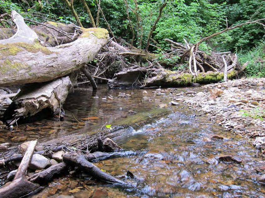
Fires create immediate risk in the landscape including:
Increased runoff. Fire-impacted landscapes absorb less rainfall due to the loss of vegetation
and changes to the soil. During storms, runoff could double, increasing the amount of water
on property, driveways, roads, and in waterways. The CZU Lightning Fire burned areas that
receive the highest rainfall totals in Santa Cruz County, creating a serious concern.
Increased erosion – Bare soils, loss of vegetation, and increased runoff will result in more soil
movement, especially on moderate and steep slopes. For the next few years, debris flows
and landslides are more likely to occur and create a hazard for lives and property.
Increased sediment – Increased erosion will result in more sediments flowing downslope and
into waterways, streams, and rivers. Slope failures, landslides, and debris flows could deposit
sediments including cobbles and boulders onto roads, properties, and in waterways.
Increased tree fall - More trees will fall into drainage courses and creeks. Fallen trees could
block road culverts, divert water, and cause bank erosion. However, fallen trees and other
wood also help to stabilize channels and create stream habitat complexity that benefits
endangered coho salmon, threatened steelhead, and other fish and wildlife.
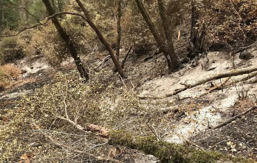
After the Lockheed Fire 2009
The plant communities of the Santa Cruz Mountains are adapted to periodic fire and many plants
will reseed, resprout, or recover from the fire over time. Fire liberates nutrients, clears excessive
fuel loads, and rejuvenates fire dependent plant communities such as chapparal and sandhills.
Allow areas to recover naturally unless action is needed to control erosion.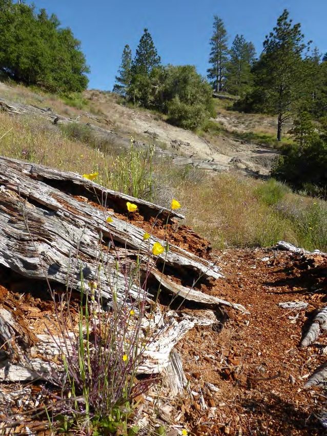
Post-Fire Property Assessment
Hazardous Materials, Ash and Structure Debris Removal
For detailed information, visit santacruzcounty.us/firerecovery
The County’s Environmental Health Division is coordinating the safe removal of household
hazardous materials (Phase 1), and then ash and structure debris (Phase 2) from your property.
The removal of hazardous materials, ash and structure debris will help protect our community
drinking water supplies, fish, and wildlife.
After Phase 1 and before Phase 2, install protective measures downslope of the structure to
limit toxic runoff into waterways. See the website for information about installing weed-free
mulch, wood chips, or other measures.
After hazardous materials, ash and structure debris are removed, assess your homesite for
erosion potential and take appropriate actions.
Hazardous Trees
Work with a Registered Professional Forester or arborist to evaluate trees.
For personal safety, any burned tree within falling distance to the homesite should be
evaluated for removal. Trees farther from the home should be assessed for fire damage and
left to regenerate whenever possible. Even when burned, tree roots provide slope stability.
Whenever possible, leave dead trees for wildlife habitat.
Left: Potentially hazardous material from a home lost in the fire.
Right: Acorn woodpecker using dead tree to store acorns (Mike’s Birds)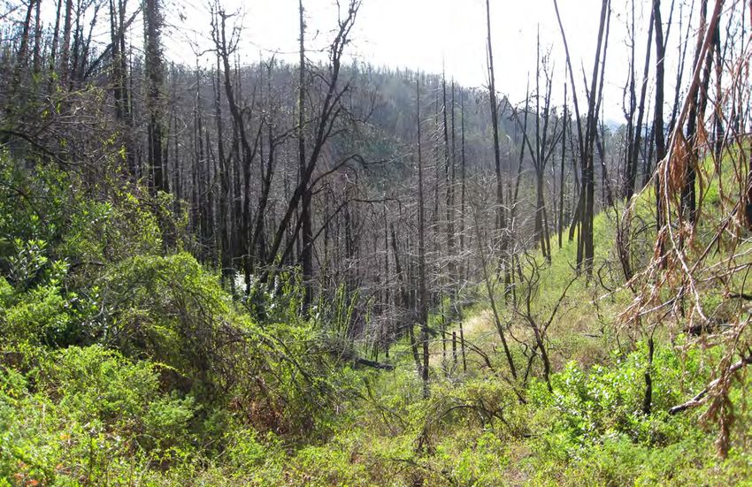
Post-Fire Property Assessment
Home Drainage
Learn about home drainage at www.rcdsantacruz.org/publications.
Look carefully to see if any underground drainage pipes were burned or damaged.
Think about where existing drainage patterns may cause problems with increased
runoff. Solutions could be as simple as providing an outlet energy dissipation
structure such as boulders or a gabion basket, or upsizing a ditch or berm.
Plastic sheeting is usually the wrong approach to erosion control. The plastic holds
soil moisture, kills vegetation and increases runoff.
Driveways and Private Roads
Inspect your driveways and private roads for fire damage, which can include burned
culverts or debris-filled ditches. Do maintenance and make repairs prior to the rainy
season. Clear ditches and culvert inlets before, during and after storms.
Expect higher runoff this winter! Driveways and private roads will need more
frequent inspections and maintenance for the next few years. Address problems as
soon as possible to avoid more expensive repairs.
Contact the Resource Conservation District (RCD) of Santa Cruz County for technical
assistance. Some funding is available for private roads within the San Lorenzo
Watershed.
Left: Poles protect a culvert inlet from branches and sediment; Right: Culvert with rocks at outlet for energy dissipation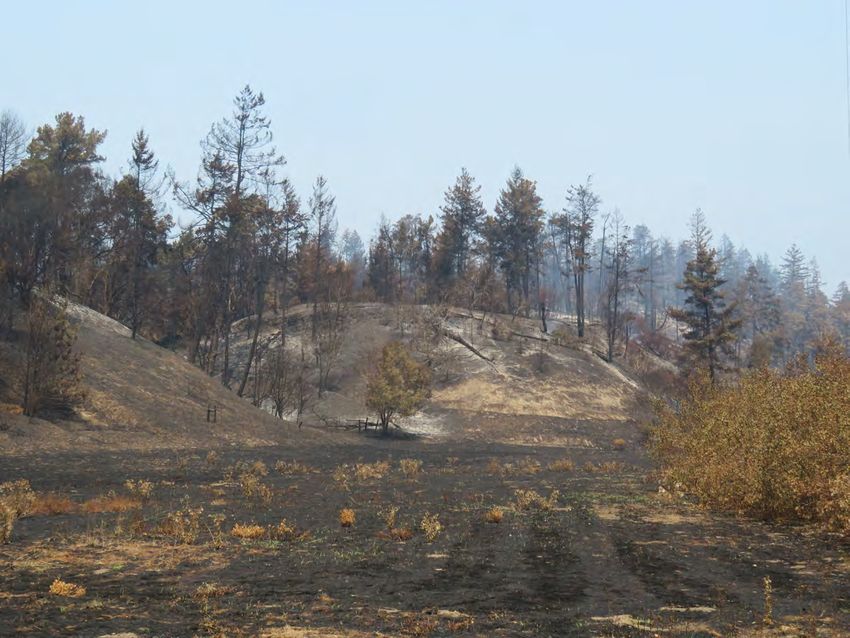
Post-Fire Property Assessment
Native Plant Communities
The fire impacted a broad range of native plant communities, including redwood forests,
mixed conifer forests, oak woodlands, chapparal, riparian and Sandhills.
The Santa Cruz Sandhills are a unique community of plants and animals found only on
outcrops of Zayante sands. Native Sandhills plants are adapted to recurring fire and many
will regenerate from seed or resprout. Native Sandhills animals rely on native plants for
food and habitat. Limit all mulching and do not use wood chips in Sandhills habitat.
For all habitats, especially Sandhills, all replanting should consist of local, native plants.
Nurseries and native plant sources are listed on both the County and RCD websites.
If necessary, use sterile erosion control seed (e.g. sterile barley) and weed free mulch (e.g.
rice straw). Where possible, remove non-native plants that invade fire-impacted areas.
Left: Sandhills; Right: Variable Checkerspot on Santa Cruz wallflower; Sandhills restoration with native plants (Photo: Jodi McGraw)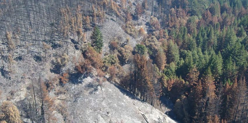
Post-Fire Property Assessment
Hillslopes and Erosion Control
Consider NATURE as the first and best post-fire restoration practice. Our native plants are
fire adapted and many of them will reseed, resprout, or regenerate over the next year.
Allow forest litter and burned plants to remain to reduce the erosive nature of raindrops.
Even fire damaged shrubs and trees will have viable root systems and many will resprout in
the coming months. When possible, stay off fire impacted areas to reduce damage to
delicate soils and roots.
Improperly installed erosion control measures can cause expensive damage! If you are
concerned about erosion, get assistance from the Resource Conservation District (RCD) or an
erosion control professional. More information is on County and RCD websites.
In areas with little or no vegetation, mulching with weed-free straw or chipped wood are
simple options for post-fire erosion control. Spread mulch lightly, 2-3” in depth, to allow for
native regeneration. Due to the fire risk, mulch should not be placed within 10’ of the house
or on areas where fire may be smoldering underground.
If you need to remove hazardous trees, get branches chipped and use the wood chips in bare
areas. Do not share chipped wood beyond your immediate neighborhood to prevent
spreading Sudden Oak Death fungus or other pathogens.
Left: Regeneration from 2009 Lockheed Fire; Right; post-fire conifer seedlings, fallen leaves left on the ground for erosion control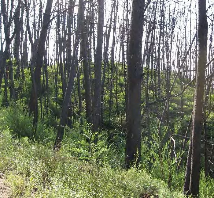
Post-Fire Property Assessment
Waterways and Riparian Corridors
Fire damaged trees are an important source of instream wood and should be allowed to
fall into the stream or river. Leave standing riparian trees to regenerate or to serve as
wildlife habitat.
The County of Santa Cruz protects the stream channel and the adjacent riparian corridor
as a sensitive habitat. For perennial streams, the protected riparian corridor includes the
channel and 50’ on either side of the mean rainy season flowline. Within this protected
area, the accumulation of stream wood and sediment will be allowed as long as it is not
damaging property or roads.
While excess fine sediments can be detrimental to water supplies and aquatic habitat,
gravel and cobble sediments build up the streambed which supports bank stability and
helps create spawning habitat for steelhead and coho salmon.
If you are concerned about wood in a stream, contact County of Santa Cruz, Public
Works Drainage (831) 477-3999 for an evaluation and technical assistance.
Stream wood in Scott Creek provides habitat complexity for coho salmon and steelhead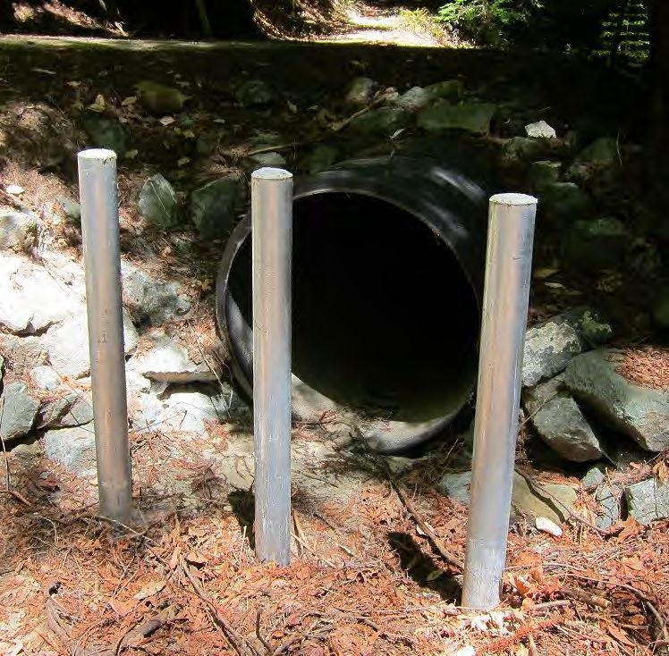
Post-Fire Threats to Life and Property
In some areas, there are serious threats to life and property, including debris flows,
landslides and flooding. These threats are most serious in the first 2 years after the fire.
Identify if your property is within one of these threatened areas - which includes areas
outside the fire zone - become informed and be prepared this winter with evacuation plans.
Flood Risk
Due to high runoff, flows will increase more rapidly and flooding is more likely in the
rainy season immediately following a fire
Localized flooding can result when large deposits of wood and sediment block the channel
Flooding can affect areas downstream of the fire area
Be prepared and be ready to evacuate when needed
Landslides
Landslide risk is higher following a fire due to increased runoff and loss of vegetation
The geology of the hillside determines the risk of landslides
Landslides are a result of slippage of one layer of material over another with saturated
conditions; Landslides can be deep or shallow and can occur quickly or slowly
Concentrated runoff can start a landslide; work with neighbors to safely direct runoff
Consult with a geologist if you are concerned about landslide risk
Left: Flooding on the San Lorenzo River in 2017 (Shmuel Thaler, Santa Cruz Sentinel); Right : Santa Cruz landslide (County staff)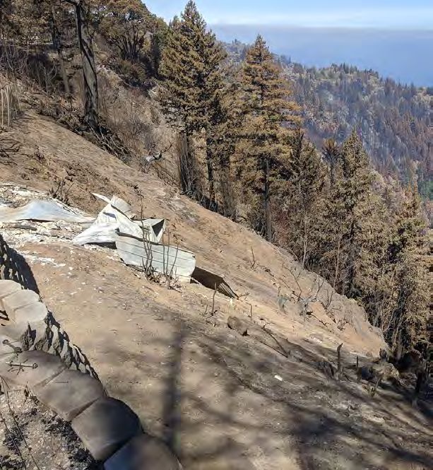
Debris Flows
A debris flow is a fast-moving mass of material—a slurry of water, rock, soil, vegetation -
even boulders and trees—that moves downhill by sliding, flowing or falling. They can
damage property and endanger lives as they rush down steep slopes, along
drainage courses and onto flatter areas.
Learn if you are at risk from debris flows and be prepared to leave your home
during predicted intense rain events. Stay Safe, Evacuate.
Debris flows occur in minutes! Due to their speed, you need to evacuate prior to the
storm event to stay safe. Even if your property did not burn, there can be a risk from
upslope areas. The County will continue to study the potential debris flow hazard and
provide information to those at risk.
Debris flows are triggered by intense Debris Flows in the Santa Cruz Mountains
rainfall on fire-impacted steep slopes,
such as 1/4” of rain in 15 minutes.
Storms with predicted high intensity
rainfall create a debris flow hazard.
Debris flows are extremely fast events and due
to their speed, it is necessary to evacuate prior
to the storm event to stay safe.
Evaluate Your Erosion Risk
As part of a post-fire property assessment, evaluate the erosion risk for areas beyond the
homesite. For Low and Moderate Erosion Risk, natural areas are expected to recover on their
own. For High and Very High Erosion Risk, it’s recommended that you get technical assistance
to reduce the risk to your property and safety. Remember to work with your neighbors since
runoff and erosion can cross property boundaries.
Low Erosion Risk
Relatively flat property without adjacent steep slopes
Property accessed by public road or short private road
Well-drained soils
Low or moderate fire burn intensity
Low Erosion Risk
Moderate Erosion Risk Relatively flat property = Low Erosion Risk
Low or moderate fire burn intensity
Moderately sloped property or well-vegetated and short steep slopes
Property accessed by medium length driveway or road system
Moderate Erosion Risk
Moderate slopes + low burn intensity = Moderate Erosion Risk. Leave downed trees and shrubs for erosion control.Evaluate Your Erosion Risk
High Erosion Risk
Moderately or steeply sloped property, especially with long slopes
Moderate to high fire burn intensity
Property that is adjacent to steep slopes
Property accessed by long driveways or extensive private road system
Very High Erosion Risk
Property that is steeply sloped, adjacent to steep slopes or downstream of steep slopes
High fire burn intensity
Property accessed by long driveways or extensive private road system on steep slopes
In an area identified as having a debris flow or landslide risk
If you think you may be at risk for landslides, contact a geologist for an evaluation.
If you think you may be at risk for debris flows, learn more about your risk and follow
County efforts to identify threatened properties.
During the rainy season, be aware of weather forecasts
Always leave your property if you feel unsafe!
High Erosion Risk
Above: Steep slope + high burn intensity = High
Erosion Risk;
Right: Long, steep slope + high burn intensity +
identified debris flow risk = Very High Erosion Risk Very High Erosion Risk
Right photo: Jessica deGrassiResources
County of Santa Cruz
701 Ocean Street
Santa Cruz, CA 95060
Fire Recovery website: www.santacruzcounty.us/FireRecovery.aspx
County Public Roads and Stream Wood
To report a problem with a public road or to request a stream wood evaluation,
contact DPW Drainage at (831) 477- 3999
Track Rainfall and Flood Warnings
https://santacruz.onerain.com/
Resource Conservation District (RCD) of Santa Cruz County
Post-fire information and to request site visits for technical assistance
www.rcdsantacruz.org
(831) 464-2950
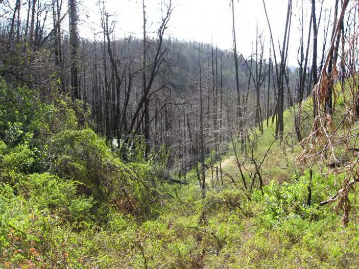
Slope in Scott Creek Watershed, 1 year after the 2009 Lockheed Fire.
Produced in partnership with the Resource Conservation District of Santa Cruz County
Brochure design and photos (except where noted): Kristen Kittleson, County of Santa CruzYou can also read