BUSHFIRE MANAGEMENT PLAN - Lots 2078 & 4537 94 Barytes RD, Cranbrook, WA
←
→
Page content transcription
If your browser does not render page correctly, please read the page content below
BUSHFIRE MANAGEMENT PLAN
        Lots 2078 & 4537
  94 Barytes RD, Cranbrook, WA

          CLIENT:   Woodside Energy Limited
  SITE LOCATION:    94 Barytes Road, Cranbrook, WA
           DATE:    9/01/2020
      SHIRE/CITY:   Cranbrook Shire
FIRE CONSULTANT:    Terry Maher
CLIENT CONTACT #    Cathy Young, Orange Owl Pty Ltd
     WOFP FILE #:   20191221
      VERSION #:    5.0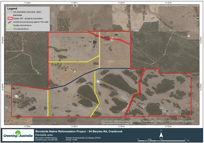
Bushfire Management Plan

                                                                  Table of contents

1     Section 1: Proposal Details ............................................................................................................... 3
2     Section 2: Land Information ............................................................................................................. 3
    2.1      Area ................................................................................................................................................................... 3
    2.2      Locality and Access Roads ................................................................................................................................. 3
    2.3      Natural Features................................................................................................................................................ 3
    2.4      Improvements ................................................................................................................................................... 3
3     Section 3: Plantation Establishment Plan .......................................................................................... 3
    3.1      Species to be planted ........................................................................................................................................ 3
    3.2      Access roads and Fire breaks ............................................................................................................................ 3
4     Fire Management Plan ..................................................................................................................... 5
    4.1      Property details ................................................................................................................................................. 5
    4.2      Location and contact details of neighbours ...................................................................................................... 5
    4.3      Local Fire Brigades............................................................................................................................................. 5
    4.4      Risk of ignition ................................................................................................................................................... 5
    4.5      Detection of fires............................................................................................................................................... 5
    4.6      Location of fire control equipment in Cranbrook area ..................................................................................... 6
    4.7      Initial attack on fires .......................................................................................................................................... 6
    4.8      Firebreaks .......................................................................................................................................................... 6
    4.9      Method of firebreak maintenance. ................................................................................................................... 7
    4.10     Water supplies. ................................................................................................................................................. 7
    4.11     Direction indicators of waterpoints, road signs, and other features. ............................................................... 7
    4.12     Surrounding fuels. ............................................................................................................................................. 7
5     Site photos ...................................................................................................................................... 8
6     Figures ........................................................................................................................................... 11
7     Appendices .................................................................................................................................... 15

Figures
Figure 1. Property boundaries and existing fences......................................................................................................... 11
Figure 2. Map showing neighbour contact details.......................................................................................................... 12
Figure 3. Revegetation fire management map. .............................................................................................................. 13
Figure 4. Local vegetation map to AS3959:2018 showing photopoint locations. .......................................................... 14

Appendices
Appendix 1 Cranbrook Shire annual firebreak notice. .................................................................................................... 15

                                                                                                                                                                         Page | i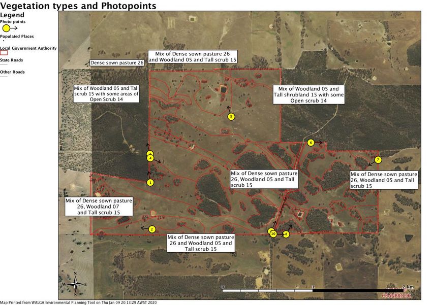
Bushfire Management Plan

Document control
Client: Cathy Young Orange Owl Pty Ltd on behalf of Woodside Energy Limited
                                                                               Author/reviewer and
   Report version                            Purpose                                                           Date submitted
                                                                               accreditation details
 Draft 1.0               BMP concept development                             Terry Maher                     2/1/2020
 Draft 2.0               BMP with site details and mapping                   Alan Hordacre                   6/1/2020
 Draft 3.0               Edited draft document                               WOFP team                       8/1/2020
 Draft 4.0               Imported into WOFP template, Final edits            Dr David Deeley                 13/1/2020
 Rev0                    Woodside edits                                                                      20/1/2020

Disclaimer

The recommendations and measures contained in this assessment report are based on the requirements of the Australian
Standards 3959 – Building in Bushfire prone Areas, WAPC / DFES Guidelines for Building in Bushfire Prone areas (State Planning
Policy 3.7) and CSIRO’s research into Bushfire behaviour. These are considered the minimum standards required to balance the
protection of the proposed dwelling and occupants with the aesthetic and environmental conditions required by local, state and
federal government authorities. They DO NOT guarantee that a building will not be destroyed or damaged by a bushfire. All surveys
and forecasts, projections and recommendations made in this assessment report and associated with this proposed dwelling are
made in good faith on the basis of the information available to the fire protection consultant at the time of assessment. The
achievement of the level of implementation of fire precautions will depend amongst other things on actions of the landowner or
occupiers of the land, over which the fire protection consultant has no control. Notwithstanding anything contained within, the fire
consultant/s or local government authority will not, except as the law may require, be liable for any loss or other consequences
(whether or not due to negligence of the fire consultant/s and the local government authority, their servants or agents) arising out
of the services rendered by the fire consultant/s or local government authority.

                                                                                                                         Page | ii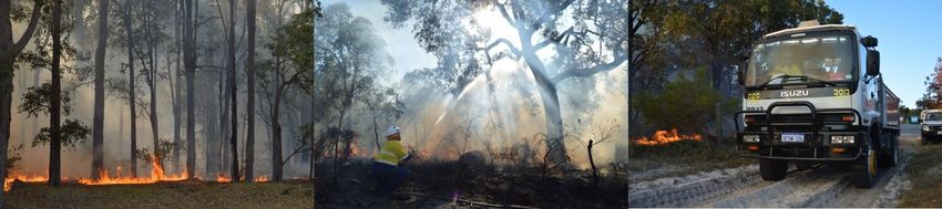
Bushfire Management Plan

1 Section 1: Proposal Details

Woodside Energy Limited is the landholder of 94 Barytes Rd, Cranbrook, WA (Figure 1). The property covers 399.3 ha
across two Lots (Lot 2078 and Lot 4537), located approximately 5km east of Cranbrook.

Woodside is planning to use the property to generate Australian Carbon Credit Units (ACCUs) under the Federal
Government’s Emissions Reduction Fund (ERF)1. This project establishes permanent plantings of a mix of native tree
species on land that has been used for agricultural activities. The tree species will be selected to be representative of
the remnant vegetation in the local area. It will provide biodiversity and ecological benefits including restored
landscape linkages, habitat creation and protection of fauna species. Social benefits will be realised, including
employment opportunities.

1
    Established under the Carbon Credits (Carbon Farming Initiative) Act 2011

2 Section 2: Land Information
2.1        Area
           The total area of Lots 2078 and 4537 is 399.3 ha of which approximately 298.7 ha is plantable.

2.2        Locality and Access Roads
           The property is located approximately 4 km east of Cranbrook, north of Salt River Road on Barytes Road which
           passes through Location 4537.

2.3        Natural Features
           The land is high in the local landscape with approximately 50 m of relief.

2.4        Improvements
           A large general-purpose shed will be retained on the property. All existing dams will be retained post planting
           and their suitability for access and status updated on the site map at the front gate annually.

3 Section 3: Plantation Establishment Plan
3.1        Species to be planted
           Based on a detailed assessment of the plant species in the remnant vegetation on the property, the following
           mixture of native species will be direct seeded or planted at the property:
               • Eucalyptus wandoo,
               • Eucalyptus marginata,
               • Eucalyptus pachyloma,
               • Eucalyptus preissiana,
               • Eucalyptus decipiens,
               • Agonis theiformis,
               • Kunzea montana,
               • Melaleuca thymoides,
               • Leptopspermum erubescens.

3.2        Access roads and Fire breaks

                                                                                                                Page | 3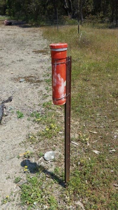
Bushfire Management Plan
The property is accessible through two wire gates off Barytes Road, a gravel Shire Road that runs to the North
of Salt River Road, Cranbrook.

                                                                                                     Page | 4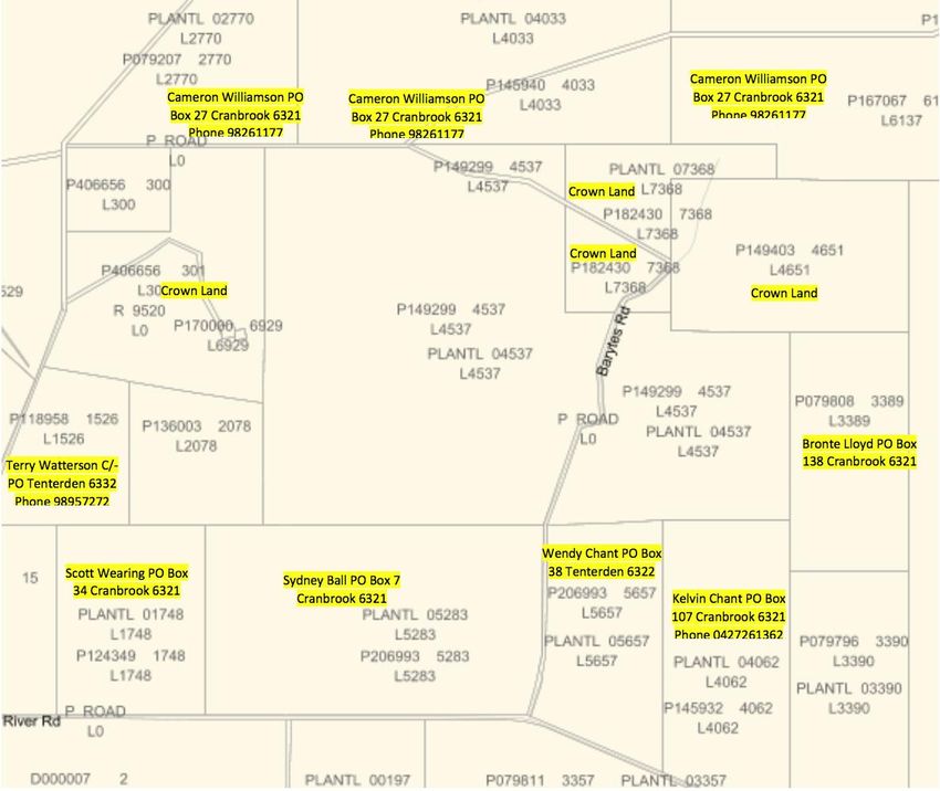
Bushfire Management Plan
4 Fire Management Plan
4.1 Property details
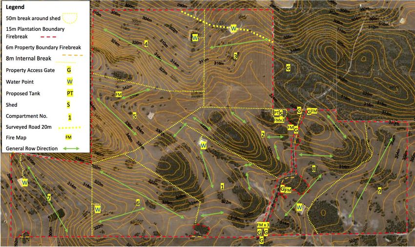
A Revegetation Fire Management Map (Figure 3) will be located within red, steel picket mounted, map canisters
at the water tank and access gates. This map will assist with navigation for fire suppression. Property and
Revegetation Fire Management Maps will also be made available to the Local Fire Control Officer and immediate
neighbours.
4.2 Location and contact details of neighbors
Details of neighbouring properties are provided in Figure 2.
4.3 Local Fire Brigades
The property falls within the East Cranbrook volunteer brigade area.
Brigade contact persons are outlined below:
Fire Control Officer, Captain - H Smith
9825 8233, Mobile: 0427 258 237
Lieutenant - F Fiegert
9826 1180, Mobile: 0419 933 430
Secretary - P Horrocks
9826 1179, Mobile: 0427 361 179
Radio Operator - H Smith
VHF Call Sign - Balicup 1
F Fiegert
VHF Call Sign - Balicup 2
P Horrocks
VHF Call Sign - Balicup 3
4.4 Risk of ignition
Potential ignition sources are mainly lightning strikes, adjoining roads, recreationists and normal adjacent
farming activities.
There will be a very low risk of ignition within this property as all machinery operations will be carried out during
the winter and spring months and once the native trees have been established, and as they are permanent
plantings with no harvest period, there will be minimal vehicle and machinery operations at the property.
During seeding and planting operations there will be a small supply of hydrocarbons at the site to re-fuel
machinery. This will be removed once planting is complete.
4.5 Detection of fires
Detection of fires is generally via a member of the community or public phoning 000. If a notification is received
through the state emergency network the Department of Fire and Emergency Services advising the Shire of
Page | 5
Bushfire Management Plan
        Cranbrook volunteer bushfire brigades. To facilitate efficient fire detection communication, or a response, local
        bushfire brigades have a VHF communications system which supplements the local farmer radio network via
        UHF radios.

4.6     Location of fire control equipment in Cranbrook area
        Two Brigade - 4.4 broadacre appliances are located at Tenterden Hall (approx. 10 km away) and Cranbrook
        townsite (approx. 7 km) both are generally manned by volunteer brigades.

        Fast attack appliances are maintained by a number of local Cranbrook farmers. The local bushfire brigade can
        alert these property owners if a fire is detected and coordinate access, watering points and the overall response.

        During establishment and maintenance of the native vegetation plantation there will be vehicles equipped with
        fire extinguishers.

4.7     Initial attack on fires
        The initial attack on a bushfire will be coordinated by the Shire of Cranbrook volunteer bushfire brigades and
        supported by neighbours if required. The overall response and communication with be coordinated by the local
        volunteer fire control officer and will make be based on their assessment of the extent and potential for
        escalation of the fire.

        Experienced brigade personnel will assess the fire behaviour and coordinate the response to address the
        following order of priority:
        • Human Life
        • Community assets
        • Cost of suppression in relation to the values threatened

        Whilst considering the wildfire behaviour and values, the response strategy will follow this order of priority as a
        guide:
        • Direct attack on the head fire where resources and conditions allow
        • Indirect attack on the head fire by extinguishing the flank fire while working towards the head fire
        • Limit fire spread to predetermined internal strategic firebreaks or compartment boundary firebreaks
        • Limit fire spread to property boundary firebreaks
        • Fall back to neighbouring properties, roads or where the fire can be safely extinguished
4.7.1    Emergency Response Plan
         Woodside will put a site specific Emergency Response Plan (ERP) in place for the property. This will cover
         Woodside’s response in any type of emergency situation which may arise on the property (e.g. fire, medical
         emergency when works are underway).

         The ERP will be lodged with Woodside’s 24-hour Communications Centre (WCC). The WCC is located at
         Woodside’s head office in Perth Western Australia and is tasked as the central communications hub for all of
         Woodside’s assets and facilities.

         The ERP will include a flow-chart which outlines the actions taken if an emergency situation should arise. A
         copy of this plan will be provided to each of the immediate neighbours of the property and contact details for
         each of these will be included in the ERP so that the WCC can contact them directly in the event of a emergency.

4.8     Firebreaks
        Firebreaks will be constructed and maintained in accordance with the Cranbrook annual Shire Fire Break Notice
        as a minimum standard. A copy of the current order is provided as Appendix 1 of this report.

                                                                                                                 Page | 6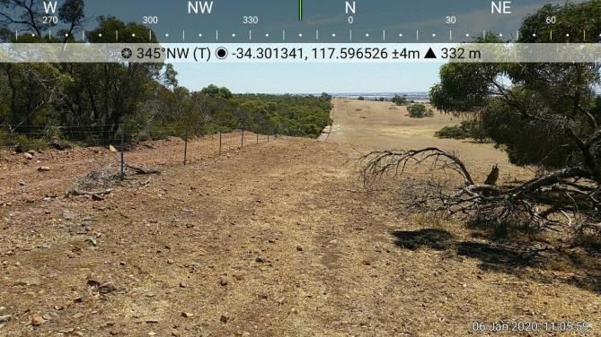
Bushfire Management Plan
      The Revegetation Fire Management Map (Figure 3) spatially describes the firebreaks to be established and
      maintained at this property.

4.9   Method of firebreak maintenance
      The network of boundary and proposed internal firebreaks will be established by herbicide spraying and, where
      require, earthmoving equipment. Once established, firebreaks will be assessed annually and maintained as
      required. Due to the topography and exposed rock up to and along sections of the boundary, some of the
      boundary firebreaks may not meet the Shire’s requirement.

      A minimum of 6 meter boundary access will be established on all boundaries, while 15 meter wide firebreaks
      will follow the plantation boundary adjacent to remnant vegetation where property boundary access is difficult
      due to terrain or remnant vegetation. These areas are marked on the attached plan Revegetation Fire
      Management Map (Figure 3).

4.10 Water supplies
      The primary water point will be a 110,000 litre water storage tank, which will be established next to the shed on
      the property. This tank will be filled by rainfall collected from the shed roof catchment. The status of the tank
      will be assessed annually, and should water volume fall below 50,000 litres, water will be carted in to maintain
      sufficient supply for fire suppression.
      Six existing farm dams will remain as secondary water points. The status of these secondary water points will be
      assessed annually and site maps will be updated to reflect their suitability for fire suppression based on
      accessibility and water levels.
      Firebreaks and internal roads will provide access to the primary and secondary water points, which ensures that
      fire appliances meet the turn turnaround time specified in the Cranbrook Shire Annual Firebreak Notice.

4.11 Direction indicators of waterpoints, road signs, and other features
      All dams and other sources nominated as suitable for use as water points are marked clearly on the Revegetation
      Fire Management Map (Figure 3). Compartment boundaries and water points will be suitably sign posted prior
      to summer of 2020/21.

4.12 Surrounding fuels
      There are Crown reserves containing block remnant vegetation to the north-east and north-west of the property
      (Figure 4). The Crown land firebreaks will also be assessed during establishment of the native plantings and
      annually thereafter. Should they require attention the relevant state agency will be contacted.

      All other neighbouring properties are predominantly a mixture of pastured grazing and cropping paddocks with
      small clusters of remnant vegetation.

                                                                                                             Page | 7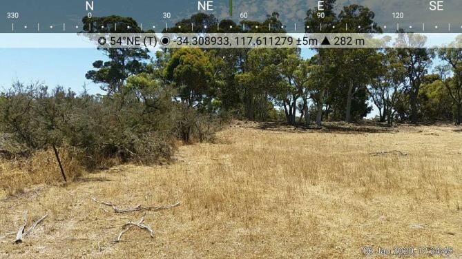
Bushfire Management Plan

5 Site photos

                 GROUND PHOTO 1                                    GROUND PHOTO 2
DIRECTION:   N          SAMPLE POINT:   SAMPLE   DIRECTION:   W           SAMPLE POINT:   SAMPLE

                 GROUND PHOTO 3                                    GROUND PHOTO 4
DIRECTION:   N          SAMPLE POINT:   SAMPLE   DIRECTION:   SE          SAMPLE POINT:   SAMPLE

                                                                                             Page | 8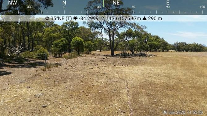
Bushfire Management Plan
                  GROUND PHOTO 5                                    GROUND PHOTO 6
DIRECTION:   N           SAMPLE POINT:   SAMPLE   DIRECTION:   E           SAMPLE POINT:   SAMPLE

                  GROUND PHOTO 7                                    GROUND PHOTO 8
DIRECTION:   SW          SAMPLE POINT:   SAMPLE   DIRECTION:   NE          SAMPLE POINT:   SAMPLE

                                                                                              Page | 9
Bushfire Management Plan
GROUND PHOTO 9 GROUND PHOTO 10
DIRECTION: NE SAMPLE POINT: SAMPLE DIRECTION: E SAMPLE POINT: SAMPLE
GROUND PHOTO 11
DIRECTION: BEARING SAMPLE POINT: SAMPLE DIRECTION: BEARING SAMPLE POINT: SAMPLE
Deliberately left blank
Example of Fire canister containing maps and other
information for suppression crews
Page | 10Bushfire Management Plan
6 Figures
Figure 1. Property boundaries and existing fences.
Page | 11Bushfire Management Plan
Woodside Property
Woodside Property
Woodside
Property
Figure 2. Map showing neighbour contact details.
Page | 12Bushfire Management Plan
Figure 3. Revegetation fire management map.
Page | 13Bushfire Management Plan
Figure 4. Local vegetation map to AS3959:2018 showing photopoint locations.
Page | 14Bushfire Management Plan
7 Appendices
Appendix 1 Cranbrook Shire annual firebreak notice.
Page | 15Bushfire Management Plan
Page | 16Bushfire Management Plan
Page | 17Bushfire Management Plan
Page | 18Bushfire Management Plan
Page | 19You can also read