NATIONAL INSTRUMENT 43-101 TECHNICAL REPORT SIMKAR GOLD PROPERTY
←
→
Page content transcription
If your browser does not render page correctly, please read the page content below
NATIONAL INSTRUMENT 43-101
                      TECHNICAL REPORT
                   SIMKAR GOLD PROPERTY
                        Louvicourt Township, Quebec Canada
                                    NTS 32C/04

                                     Prepared for:

                                          and

                                                                      ]

                                          by

MRB & Associates                                Abderrazak Ladidi M.Eng., P.Geo
Suite 2100                                      abderrazak@mrbweb.com
1748 chemin Sullivan,
Val-d’Or, QC J9P 7H1
Tel: (819) 874-8768 Fax: (819) 874-8771         November 19th, 2013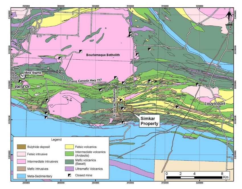
2013 Technical Report - Simkar Gold Property 2
TABLE OF CONTENTS
1.0 SUMMARY ............................................................................................................. 4
1.1 Property Description and Ownership ....................................................................... 4
1.2 Geology and Mineralization ............................................................................... 5
1.3 Recent Exploration ........................................................................................... 6
1.4 Resource Estimation ........................................................................................ 6
1.4 Conclusions and Recommendations .................................................................... 8
2.0 INTRODUCTION ................................................................................................. 9
2.1 Site Visits ........................................................................................................... 9
2.2 Sources of Information ....................................................................................... 10
2.3 Units and Abbreviations .................................................................................. 10
3.0 RELIANCE ON OTHER EXPERTS ........................................................................... 11
4.0 PROPERTY DESCRIPTION AND LOCATION ............................................................ 12
4.1 Environmental Liabilities ................................................................................. 16
4.2 Work Permits and Plans .................................................................................. 16
4.3 Details of Property Agreement ......................................................................... 16
5.0 ACCESSIBILITY, CLIMATE, LOCAL RESOURCES, INFRAS. AND PHYSIOGRAPHY .......... 17
6.0 HISTORY ......................................................................................................... 18
6.1 Early Work, 1939-1995 .................................................................................. 18
6.2 Work by Megastar, 1996-2004 ........................................................................ 20
6.3 Work by Megastar, 2006-2008 ........................................................................ 20
6.4 Work by Eloro, 2010-2013 .............................................................................. 21
7.0 GEOLOGICAL SETTING ...................................................................................... 22
7.1 Regional Geological Setting ............................................................................. 22
7.2 Property Geology ........................................................................................... 22
7.3 Metamorphism and Alteration .......................................................................... 24
8.0 DEPOSIT TYPES AND MINERALIZATION ............................................................... 26
8.1 Deposit types.................................................................................................... 26
8.2 Mineralization ................................................................................................... 26
8.2.1 B-Zone .................................................................................................. 27
8.2.2 A-Zone .................................................................................................. 28
8.2.3 C-Zone .................................................................................................. 28
8.2.4 Pillar Zone .............................................................................................. 29
8.2.5 B-A Deformation Feature .......................................................................... 29
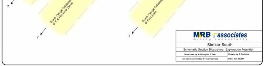
8.2.6 East Zone Shear ...................................................................................... 30
8.2.8 Montana Zone ......................................................................................... 31
8.2.9 East Boundary Zone ................................................................................ 31
8.2.10 Western Boundary Zone ....................................................................... 32
8.2.11 Base-metal Mineralization ...................................................................... 32
9.0 EXPLORATION ..................................................................................................... 33
10.0 DRILLING .......................................................................................................... 33
11.0 SAMPLE PREPARATION, ANALYSES AND SECURITY ............................................. 34
12.0 DATA VERIFICATION ...................................................................................... 35
12.1 Analysis of Quality Control Data from Assay results .............................................. 35
12.2 CSRM Standards .............................................................................................. 36
12.3 Blanks............................................................................................................ 36
12.4 Coarse-pulp duplicates: .................................................................................... 37
12.5 SUMMARY OF QAQC ANALYSES.......................................................................... 38
13.0 MINERAL PROCESSING AND METALLURGICAL TESTING ...................................... 39
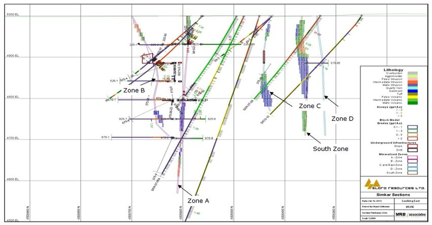
14.0 MINERAL RESOURCE AND MINERAL RESERVE ESTIMATES ................................... 40
14.1 Data .............................................................................................................. 40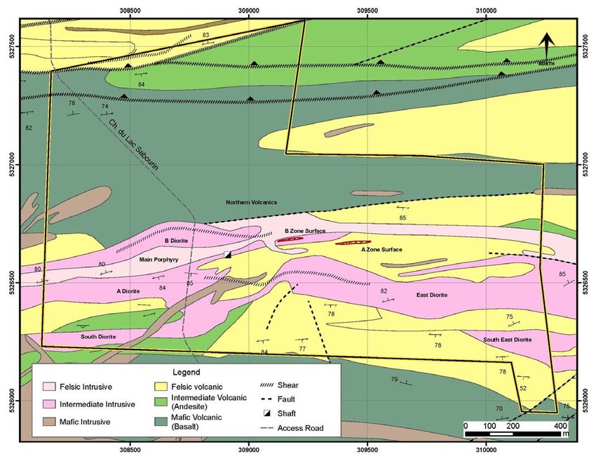
2013 Technical Report - Simkar Gold Property                      3

  14.2 Modelling........................................................................................................ 40
  14.2.2 Mineralization modelling................................................................................. 40
  14.2.3 Surface topography and overburden ................................................................ 40
  14.3 Underground development and stopes ................................................................ 40
  14.4 Statistical Analysis ........................................................................................... 46
  14.4.1 General Statistics and Grade Capping .............................................................. 46
  14.4.2 Compositing ................................................................................................. 46
  14.6 Variography .................................................................................................... 46
  14.7 Block Modelling ............................................................................................... 48
  14.8 Grade Estimation Methodology .......................................................................... 48
  14.9 Grade Estimate Validation ................................................................................. 50
  14.9.1 Composites vs interpolated block .................................................................... 50
  14.9.2 Classification ................................................................................................ 50
  14.10 Resource Estimate ......................................................................................... 51
15.0 ADJACENT PROPERTIES ...................................................................................... 51
16.0    OTHER RELEVANT DATA AND INFORMATION ..................................................... 51
17.0    INTERPRETATION AND CONCLUSIONS.............................................................. 51
18.0    RECOMMENDATIONS...................................................................................... 52
19.0    REFERENCES ................................................................................................ 53
CERTIFICATE OF QUALIFICATION ................................................................................ 54

LIST OF FIGURES

Figure   4-1: Simplified map showing regional location of the Simkar Property ..................... 12
Figure   4-2: Map showing local geology and location of Simkar Gold Property...................... 13
Figure   7-1: Simplified geological map of the Simkar Property area .................................... 22
Figure   8-1: Diagrammatic composite east-west long section ............................................ 26
Figure   12-1: Summary of Blank assay values from the 2010 to 2012 drilling programs ........ 36
Figure   12-2: Correlation of original and duplicate assay results. ....................................... 36
Figure   14-1: Isometric view (looking north) showing the interpreted mineralized zones ....... 41
Figure   14-2: Section 9075E (looking East) .................................................................... 42
Figure   14-3: Section 8925E (looking East) .................................................................... 43
Figure   14-4: Isometric view of the underground void model............................................. 44
Figure   14-5: Zone C search ellipse orientation based on variography ................................ 46

LIST OF TABLES

Table   4-1: List of mining concessions ........................................................................... 14
Table   6-1: Summary of Diamond drilling programmes by Eloro 2010-2012 ........................ 20
Table   12-1: Percentage of success for each standard type. .............................................. 35
Table   14-1 Eloro Diamond-Drilling at Simkar project ....................................................... 39
Table   14-2: Summary of Variography ........................................................................... 46
Table   14-3: Simkar Block model parameters ................................................................. 47
Table   14-4: Domain Coding of Wireframes, Solids and Surfaces in the Block Model. ............ 47
Table   14-5: Attributes of the Block Model Project ........................................................... 47
Table   14-6: Sample Search Parameters ........................................................................ 48
Table   14-7: Comparison Between Composites and Interpolated (OK-Model) Blocks ............. 49
Table   14-8 Simkar Project Resources** at Various Cut-off Grades .................................... 50
Table   18-1: Budget for Recommended Work Programs.................................................... 51
2013 Technical Report - Simkar Gold Property        4

1.0 SUMMARY

This technical report (the “Report”) was prepared at the request of Mr. Jean-Marc Lacoste,
President and Chief Executive Officer of Monarques Resources Inc., (“Monarques”), and Mr.
Thomas Larsen, President and CEO of Eloro Resources Ltd. (“Eloro”). Monarques is a
Canadian-based, public company, currently trading on the Toronto Venture Stock Exchange
(TSX:V) under the symbol of MQR, whereas Eloro is a Canadian based, publicly-held company
trading on the TSX Venture Exchange under the symbol of ELO. Monarques is a reporting
issuer in British Columbia, Alberta, Ontario and Québec, with its corporate office at 450, Gare
du Palais Street, Québec (Québec), Canada G1K 3X2. Eloro is a reporting issuer in British
Columbia, Alberta and Ontario, with its corporate office at 20 Adelaide Street East, Suite 301,
Toronto (Ontario), Canada M5C 2T6.

In August of 2013, Monarques and Eloro commissioned the author, Mr. Abderrazak Ladidi (the
“Author”) of MRB & Associates Inc. (“MRB”), of Val-d’Or, Quebec, to prepare a Mineral
Resource Estimate and accompanying Technical Report (the “Report”) in accordance with
National Instrument (NI) 43-101 on the Simkar Gold Project (the ”Project” or, the “Property”),
which comprises two (2) contiguous mining concessions (2.26 km2) and eleven mineral claims
(1.77 km2) in the prolific Val-d’Or Gold Mining Camp, 20 km east of Val-d’Or, Québec. The
Simkar Project is currently being explored pursuant to an option agreement with Eloro
Resources Ltd. (TSX-V: ELO), whereby Monarques was granted the right to earn a 50%
interest in the Project. Monarques are the current operators on the Property and are carrying
out a diamond-drilling campaign; however, the results of this campaign are not included in
this Report. As at November 1st the current drilling program had completed a cumulative total
of 4209 metres in 13 holes. Eloro’s last exploration work on the Property was completed on
January 13th, 2013.

Under the terms of the agreement Eloro Resources Ltd. has sold an undivided 50% interest in
the Property in exchange for a commitment by Monarques to perform $750,000 of exploration
work on the Property. Following the fulfilment of the exploration work commitment, Eloro and
Monarques will form a joint venture with respect to the Property which will be operated by
Monarques. If the exploration work commitment is not completed on or before June 30, 2014,
the Company will have the right to rescind the sale and take back the interest in the Property
sold to Monarques.

Eloro has also issued 8 million common shares to Monarques by way of private placement at a
price of $0.015 per share. In a concurrent transaction, Eloro has also issued 3 million shares
to an arm's length creditor at a deemed value of $0.05 per share. Following the completion of
the private placement and the shares for debt issuance Monarques holds approximately 12.8%
of the issued and outstanding common shares of Eloro.

The purpose of the Report is to provide an independent Mineral Resource Estimate (MRE) for
the Simkar Project, prepared in accordance with NI 43-101. The Report will be filed on the
System for Electronic Document Analysis and Retrieval (SEDAR) (http://www.sedar.com/), as
required under applicable securities regulations.

1.1 Property Description and Ownership

The Simkar Project is an early-stage exploration property within the National Topographic
System (NTS) map sheet 32C/04 in Louvicourt Township, approximately 20 km east of Val-
d’Or, Quebec. It consists of comprises two (2) contiguous mining concessions (2.26 km2) and
eleven mineral claims (1.77 km2) totalling 225.63 ha. The Property hosts a high-grade,
2013 Technical Report - Simkar Gold Property        5

intrusion-related, shear zone, gold-quartz vein system, characteristic of most gold deposits in
Val-d’Or Gold Mining District.

At present, there is no commercial production on the Property; however, there are extensive
underground mine workings and stopes, from a former gold producer (Louvicourt Goldfield) on
the Property.

Prior production from the mine on the property came from three main zones – the A Zone, B
Zone, and C Zone. Exploration by Megastar Resources (1996-2004) identified three additional
gold-bearing zones (Pillar Zone, F Zone, and Montana Zone), and identified a high-potential
structure named the East Zone Shear.

                  Previous Production from Louvicourt Goldfields Mine
        From      To     Tons of ore mined      Grade (grams/tonne)       oz produced
        1945    1949          261,591                    4.62                31,915
        1987    1993           71,068                    8.42                20,000

1.2    Geology and Mineralization

The Simkar Property is located within the Late Archean Abitibi Greenstone Belt. It is underlain
by a thick sequence of complexly intercalated volcanic flows and pyroclastics of the Malartic
Group. Typical of the region, the sequence strikes east-west and dips steeply to the north with
top directions to the south. The rocks have undergone greenschist facies metamorphism.

Quartz-feldspar porphyry dykes and sills intrude the intercalated volcanic flows and pyroclastic
sequences in the central and southern parts of the Property. These intrusions trend east and
northeast, and dip steeply to the south. Five diorite sills underlie the Property, south of the
baseline (from north to south); B-diorite, A-diorite, East diorite, Southwest diorite, and the
Southeast diorite. The diorites are closely associate, spatially, with mineralization.

The Simkar Property contains Archean gold-vein systems that generally strike easterly. The
high-grade, intrusion-centred gold-quartz vein system is similar to the Sigma-Lamaque
deposit in Val-d’Or and many other camps in the Abitibi Belt. A secondary type of target on
the Property, little-investigated to date, are Noranda- or Matagami-type volcanogenic massive
sulphide (VMS) deposits, one of which may underlie the northwest part of the Property, at
around 1000 m depth.

Shear zones and intrusions play an important role in controlling the mineralization along the
Larder Lake - Cadillac Tectonic Zone, the focus of gold mining activity in the south eastern
Abitibi Greenstone Belt. The mineralized zones or “shoots” at Simkar follow second order
(Riedel) shear patterns and consist of quartz-carbonate-tourmaline vein systems that locally
form stock-works (vein arrays). The mineralized zones contain mainly pyrite, minor
chalcopyrite, and trace pyrrhotite, sphalerite, molybdenite, telluro-bismuthite and native gold.
Gold occurs mainly in quartz-pyrite veins as fine inclusions within pyrite or at its boundaries,
and is closely associated with the bismuth telluride.

The primary (most abundant) set of Riedel veins dips 40º towards 320º. A second set dips 35º
towards 220°. The intersection of these two sets plunges 25° towards 270º, and defines the
long axis and plunge of the ore zones.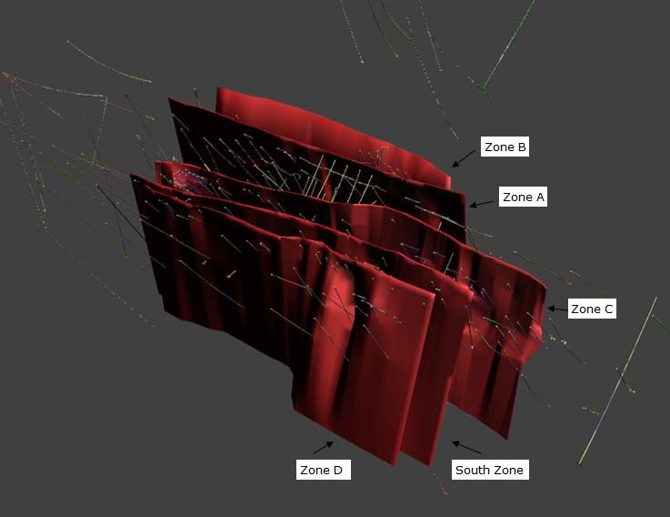
2013 Technical Report - Simkar Gold Property          6

The various mineralized veins and structures on the Property exhibit a variety of features
individually; however, they all have certain characteristics in common, which are also typical
of most Abitibi camps. Typically, mineralized zones on the Simkar Property feature quartz-
tourmaline veinlets/veins/stockwork with some carbonate and sulphides. The sulphide content
of veins varies from 3 percent to over 50%, with pyrite by far the dominant sulphide, typically
70-95% of total sulphides. Other sulphides are chalcopyrite with lesser gold/electrum, galena,
and sphalerite.

1.3    Recent Exploration

The 2004 and earlier exploration work has been described in a previous Technical Report
(Pelletier, 2004).

Megastar Development Corp. undertook additional work in 2006 and 2007. Their work
consisted of digitization of underground mine workings, the creation of a diamond-drill hole
database, surface geophysics, and a 2007 drilling program of 15 NQ diamond-drill holes
totalling 4,340 metres.

The holes intersected targets in the B, C, and East Shear zones, plus other targets. These 15
holes were added to the pre-existing database of over 500 drill holes and sample channels.

A 2008 NI 43-101 Technical Report commissioned by Megastar, and prepared by Chlumsky,
Armbrust & Meyer (Bourgoin and Sandefur, 2008) included a Resource Estimate of the Simkar
Property; however, the estimate is no longer considered valid as it was calculated using an
unconstrained, nearest-neighbour method.

From 2009-2013 Eloro Resources were the principle operators on the Property completing
23,778 cumulative metres of diamond-drilling in 54 surface holes, and collecting 8,352 core
intervals samples for assay.

in October 2013, Monarques commenced a diamond-drilling programme on the Property,
which is currently on-going. As at the date of this Report, 4200 metres in 13 holes have been
drilled; however, data from the current exploration programme are not included in this Report.

The database for the current Mineral Resource Estimate modelling incorporates 590 surface
and underground diamond-drill holes, comprising 79,590 total metres, and results from
14,506 sampled intervals.

1.4    Resource Estimation

The mineral Resources reported herein were calculated using the Canadian Institute of Mining,
Metallurgy and Petroleum (CIM), CIM Standards on Mineral Resources and Reserves,
Definitions and Guidelines prepared by the CIM Standing Committee on Reserve Definitions
and adopted by CIM Council on Dec 11, 2005.

The current Simkar Project Mineral Resource Estimate was calculated using conventional
statistical analysis, variography and grade interpolation via Gemcom® block modelling.
Utilizing 1.0 m long assays for gold (Au), the block models, within an interpreted three-
dimensional (3D) solid domain were coded with the rock codes, bulk density, and classified
into the Measured, Indicated and Inferred categories.
2013 Technical Report - Simkar Gold Property 7
The Inferred Resource estimate in this report was developed to determine whether further
exploration on the Simkar Property was warranted. Highlights of the estimation procedure
include:
A Gemcom database developed by MRB was used in the estimate, using the GEMCOM
down-hole survey calculations and GEMLOGGER drill-logs;
Some inconsistencies and minor errors were noted in the database. MRB believes that
the effect of these is not significant, given the inherent uncertainty in the Resource
estimation process;
Calculations were done using the Gemcom block models software system;
ordinary Kriging algorithm was used for the primary estimate within anisotropic
elliptical search ranges (where appropriate) and using suitable parameters. The search
distances used for the estimates are based upon an expansion factor of the semi-
variogram ranges. A block size of 10 m x 1 m x 10 m was employed;
A bulk density of 2.70 tonnes per cubic metre was used for this estimated resource
based on theoretical densities and practices in mine exploiting similar minerals in the
region Capping of gold grades did not significantly change the Resource estimate within
any one set of parameters, therefore caps were not applied.
The following table presents a summary of the Resources1, using ore blocks. Based on these
parameters, a 3.0 gpt cut-off grade appears reasonable at this stage of the project.
Inferred Measured Indicated Measured + Indicated
Cut off: grams Tonnes Grade Tonnes Grade Tonnes Grade Tonnes Grade
Ounces Ounces Ounces Ounces
per tonne (gpt) (x1000) (gpt) (x1000) (gpt) (x1000) (gpt) (x1000) (gpt)
2.0 550.87 3.73 74,473.13 34.10 4.84 5,125.12 214.53 3.82 23,909.37 248.62 4.36 29,034.49
3.0* 321.21 4.76 57,324.50 19.04 6.08 3,950.62 91.10 4.99 14,314.46 110.14 5.54 18,265.08
4.0 183.48 6.50 42,430.01 14.37 6.73 3,420.27 50.93 5.86 9,865.79 65.30 6.30 13,286.06
* a cut-off grade of 3 g/t was used for this project
1
The current Mineral Resource Estimate was calculated using the Canadian Institute of Mining,
Metallurgy and Petroleum (CIM) Standards on Mineral Resources and Reserves, Definitions
and Guidelines prepared by the CIM Standing Committee on Reserve Definitions. Mineral
resources, which are not mineral reserves, do not have demonstrated economic viability. The
mineral resource estimate may be materially affected by environmental, permitting, legal,
title, taxation, socio-political, marketing, or other relevant issues. Furthermore, the quantity
and grade of estimated Inferred Resource reported herein are uncertain and there has been
insufficient exploration to categorize them as an Indicated or Measured Resource. It is
uncertain if further exploration will result in reclassification of Inferred Mineral Resources to
the Indicated or Measured Mineral Resource categories. The tonnage numbers are rounded
according to NI 43-101 standards. Grades are calculated from Au concentrations determined
from sample assays completed by ALS Minerals using conventional Fire Assaying with 30 g
fusions and AAS finish.
Mineral Resources are not mineral Reserves and therefore do not have demonstrated
economic viability. The estimate of mineral resources may be materially affected by
environmental, permitting, legal, title, taxation, socio-political, marketing, or other relevant
issues.
The quantity and grade of reported Inferred Resources in this estimation are conceptual in
nature. There has been insufficient exploration to define an Indicated mineral resource on the
Property, and it is uncertain if further exploration will result in discovery of an Indicated or
Measured mineral Resource on the Property.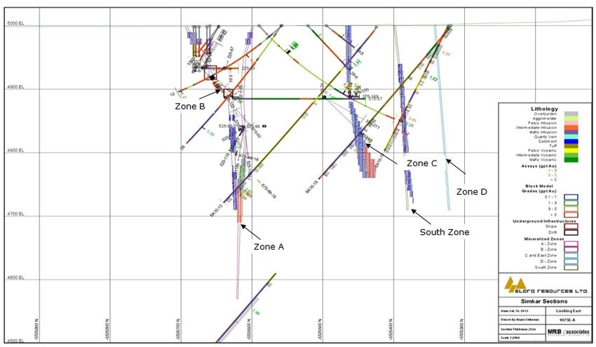
2013 Technical Report - Simkar Gold Property 8
1.4 Conclusions and Recommendations
Recent work on the Simkar Project has confirmed that the formerly explored and exploited
gold bearing structures on these properties continue to show potential for hosting additional
mineralization, and merit additional exploration work.
The resources were estimated using ordinary kriging and a parallel estimate was conducted
using the inverse distance squared method as a check. The majority of the resource has been
classified as Inferred; more drilling information is judged necessary to identify Indicated and
Measured resources.
The block size dimension (10m X 1m X 10m) was based on the existing drilling pattern and
mine planning considerations.
Although there are some discrepancies for the individual pulp re-assays, the QAQC program
employed for the Simkar Project was more than adequate.
Based on his review of the Simkar Project, the author makes the following recommendations:
Phase I - additional diamond-drilling should be carried out with a concurrent, thorough
sampling protocol, to expand the estimated Mineral Resources and provide core
material for initial metallurgical testing, which will help to determine the characteristics
of the mineralized zones;
Phase II - Additional diamond-drilling to further increase the resource volume and to
upgrade Inferred Resources to the Indicated category. Supplementary metallurgical
testing and bulk sampling to determine potential processing and recovery scenarios.
A diamond-drilling campaign that will qualify as part of the Phase I recommended programme
is currently underway on the Project, pursuant to the active Joint Venture agreement between
Monarques and Eloro. The current campaign, which is expected to be completed by mid-
December 2013, is budgeted at $750,000, of which approximately $600,000 has been
expended.
The recommended Phase II exploration programme is contingent on favourable results from
the Phase I programme.
The investment required for both phases is $5,692,500; expenditures for Phase I of the
work program are estimated at $1,950,000, whereas expenditures for Phase II of the work
program are estimated at $3,000,000.
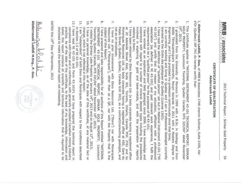
Abderrazak Ladidi (the “Author”), who is completely independent of Monarques Resources Ltd.
and Eloro Resources Ltd., and is a Qualified Persons (QP) under the terms of National
Instrument (NI) 43-101, is responsible for all Sections in this Report.
Mr. Ladidi carried out site visits to the Simkar Property on January 14th, 2013 and August 10th,
2013. On both occasions, Mr. Ladidi was accompanied by Bryan Sinkunas of MRB &
Associates.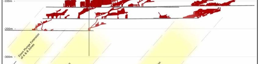
2013 Technical Report - Simkar Gold Property        9

2.0    INTRODUCTION

At the request of Monarques Resources Ltd. (“Monarques”), and Eloro Resources Ltd.
(“Eloro”), Abderrazak Ladidi of MRB & Associates (“MRB”), who is completely independent of
Monarques and Eloro and a Qualified Person (QP) under the terms of National Instrument (NI)
43-101, was contracted to prepare this Technical Report.

Monarques Resources Ltd., of Val-d’Or, QC is a public company listed on the TSX Venture
Exchange trading under the symbol MRQ. Eloro is a Canadian based, publicly-held company
trading on the TSX Venture Exchange under the symbol of ELO. This report is intended to be
used for public filing in Canada by Monarques.

The following Report presents an initial Resource Estimate, prepared by MRB, regarding the
gold deposit underlying the Simkar Property, located in Louvicourt Township, approximately
20 km east of the city of Val-d’Or, Québec, Canada.

This report does not incorporate parameters from previously released resource estimates for
the Simkar deposit. The estimates of mineral resources contained in this report conform to the
CIM Mineral Resource and Mineral Reserve definitions referred to in NI 43-101, Standards of
Disclosure for Mineral Projects.

Both Monarques and Eloro have accepted that the qualifications, expertise, experience,
competence and professional reputation of MRB’s Principals and Associate Geologists and
Engineers are appropriate and relevant for the preparation of this Report. Monarques and
Eloro have also accepted that MRB’s Principals are members of professional bodies that are
appropriate and relevant for the preparation of this Report.

The purpose of the current Report is to provide an independent, technical report and Mineral
Resource Estimate for the Simkar Property. MRB understands that this Report will be used to
support the public disclosure of the Monarques mineral resource estimate regarding Simkar,
announced on October 15th, 2013 (refer to the Monarques News Release, dated October 15,
2013). This Report will be filed on SEDAR as required by NI 43-101.

This Report is considered current as at November 19th, 2013. The effective date of the Report
is August 30th, 2013.

2.1 Site Visits

Site visits to the Simkar Property were carried out on January 14th, 2013 and August 10th,
2013 by Mr. Abderrazak Ladidi, P.Geo., of MRB, a Qualified Person (QP) as defined in NI 43-
101. On both occasions, Mr. Ladidi was accompanied by Bryan Sinkunas of MRB. During the
site visits Mr. Ladidi explored the general landscape and surface features of the Property. A
number of drill-sites (inactive) and outcrops were visited. It was noted that all visited drill
collars were correctly labelled and accurately reflected the azimuth and dip recorded on the
logs. Mr. Ladidi also reviewed Eloro’s drill core from the Project, which is stored at a secure
facility in Val-d’Or, Québec, and noted that the core on hand was securely stored and in very
good condition. Core trays were well labelled, and observation suggested that the core
cutting/splitting was well done. Sample tags were noted as being in place, and the tags and
sampled sections corresponded to those indicated in the core logs.
2013 Technical Report - Simkar Gold Property   10

2.2 Sources of Information

This report is based, in part, on internal technical reports prepared by Eloro employees (who
are also QP’s as defined in NI 43-101) and maps, published government reports, company
letters and memoranda, and public information as listed in the “References” (Section 19.0), at
the conclusion of this report. Several sections from reports authored by other consultants have
been directly quoted or summarized in this report, and are so indicated where appropriate.
The authors of this Report take responsibility for the entire report, including information
contained herein which has been provided by other experts.

2.3    Units and Abbreviations

For reported historical resource estimates, a conversion factor of 0.907 has been used in this
Report to convert short tons (tons) to metric tonnes (t). Metal values are reported in
percentage (%). Costs are reported in Canadian dollars ($) unless otherwise stated.

Grid coordinates are given in the UTM NAD 83 (Zone 19) and latitude / longitude system;
maps are either in UTM coordinates or latitude / longitude system.

For the purpose of this report, all common measurements are given in metric units. All
tonnages shown are in metric tonnes (1,000 kilograms), and precious-metal concentrations
are given in grams (gm) or grams per metric tonne (gpt). Unless otherwise indicated, all dollar
values are given in Canadian Dollars.

To convert to English units, the following factors should be used:
1 short ton = 0.907 metric tonne
1 troy ounce = 31.103 grams (gm)
1 troy ounce/short ton = 34.286 gpt

The following is a list of abbreviations used in this report:

      Abbreviation          Unit or Term
      Au                    gold
      CAD$                  Canadian dollar
      g or gm               gram
      g/t or gpt            grams per tonne
      GIS                   geographic information system
      GPS                   global positioning system
      ha                    hectare
      kg                    kilogram
      km                    kilometre
      m                     metre
      M                     million
                            Canadian Securities Administrators’ National Instrument 43-
      NI 43-101
                            101
      oz                    troy ounce
      ppb                   parts per billion
      ppm                   parts per million
      QA                    quality assurance
      QC                    quality control
2013 Technical Report - Simkar Gold Property 11
Std. Dev. standard deviation
t or tonne metric ton
US$ United States dollars
UTM Universal Transverse Mercator
yr year
/ per
3.0 RELIANCE ON OTHER EXPERTS
The Author has assumed, and relied on the fact, that all the information and existing technical
documents listed in the References section herein (refer to Section 19.0) are accurate and
complete in all material aspects.
Although copies of the tenure documents, operating licenses, permits, and work contracts were
reviewed, an independent verification of land title and tenure was not performed. The Author
has not verified the legality of any underlying agreement(s) that may exist concerning the
licenses or other agreement(s) between third parties but has relied on Monarques and Eloro to
have conducted the proper legal due diligence.
Information on tenure and permits was obtained from the Ministère des Ressources Naturelles
et de la Faune Québec (MRNFQ) website at https://gestim.mines.gouv.qc.ca, and the MRNFQ
GESTIM claim management system.
A draft copy of this Report has been reviewed for factual errors by Monarques and Eloro. MRB
has relied on Eloro’s historical and current knowledge of the Simkar Property in this regard.
Any statements and opinions expressed in this document are given in good faith and in the
belief that such statements and opinions are not false and misleading at the date of this
Report.
The Author approves and takes responsibility for the entire Report, including information
contained herein which has been provided by other experts.2013 Technical Report - Simkar Gold Property 12
4.0 PROPERTY DESCRIPTION AND LOCATION
The Property is located in the south-eastern part of the Abitibi Greenstone Belt proximal to the
Val-d’Or gold camp (Figure 4-1). The Abitibi Greenstone Belt is within the Abitibi Subprovince
of the Canadian Shield, and extends in an east-west direction for over 500 kilometres from
Chibougamau, Quebec in the northeast to west of Timmins, Ontario, making it the largest
greenstone belts in the world. It is a productive gold and base-metal producing region.
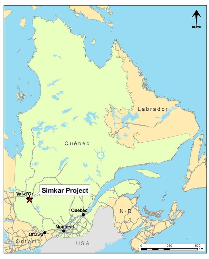
The Simkar Property is in western Québec, approximately 20 kilometres east of the
municipality of Val-d’Or, and overlies part of Louvicourt Townships. The Property lies within
National Topographic System (NTS) map sheet 32C/04 (see Figure 4-1 and Figure 4-2). The
shaft of the former Louvicourt Gold Mine (near the centre of the Property) using the Universal
Transverse Mercator (UTM) system, is approximately 308915 E, 5326620 N (North American
Datum (NAD) 83, Zone 19), or Latitude 48º-03’-51.17” north, Longitude 77º-33’-53.70” west.
A summary of the individual concessions and claims is shown in Table 4-1.
The Mining Licences have no encumbrances of any kind. The 11 claims, formerly known as the
Louvicourt Property, were obtained by Eloro from KWG Resources Inc. (TSX-V: KWG)
("KWG"), which retains a net smelter return ("NSR") royalty on gold production from the
Louvicourt Property that is 1% of the NSR, plus an additional 1% of the NSR exceeding $2,000
per troy ounce, plus an additional 1% of the NSR exceeding $3,000 per troy ounce. Eloro has
done no work on these claims since their acquisition, nor is there any work underway on these
claims.
At the time of the agreement between Eloro and Monarques, the mining leases and claims
comprising the Simkar Project were in good standing. In order to maintain the concessions,
Monarques must make annual payments to the government of Quebec totalling approximately
$19,000.
Interest in the Property stems from an Archean gold-vein systems that underlies the Property.
The high-grade, intrusion-centred gold-quartz vein system is similar to the Sigma-Lamaque
deposit in Val-d’Or and many other camps in the Abitibi Belt. A secondary type of target on
the Property, little-investigated to date, are Noranda- or Matagami-type volcanogenic massive
sulphide (VMS) deposits, one of which may underlie the northwest part of the Property, at
depth
The recommended exploration work is in accordance with the Province of Québec’s natural
resources, environmental and cultural legislation.
The reader is cautioned that previous mineral resources estimates on the Simkar Project are
not considered valid.
Currently, there are no known risk factors that would affect access, title, or the right or ability
to perform work on the property, nor are there any legal restrictions or impediments to
accessing the Property. There are no physical restrictions to gaining overland access to the
claims other than the conditions of the unmaintained secondary and tertiary access roads in
the vicinity of the Property.
Part of the permit application process involves consultation with First Nations, which will have
to be acted upon directly by Monarques as primary operator. First Nations’ land claims have
not been comprehensively settled in Québec, and their future impact on the property’s access,
title or the right and ability to perform work remain unknown.2013 Technical Report - Simkar Gold Property 13 Figure 4-3: Simplified map showing regional location of the Simkar Property
2013 Technical Report - Simkar Gold Property   14

Figure 4-4: Map showing local geology and location of Simkar Gold Property
2013 Technical Report - Simkar Gold Property    15

                                        Table 4-2:: List of mining concessions
                                                SIMKAR GOLD PROJECT
 Mining                                                     Banked
              Block #     Status    Area (ha)   Rent                         Work required           Registered Owner
 Licence                                                    credits
                                                                                               Eloro Resources Ltd (50%)
 CM 340         15        active     184.92       $0.00          $0.00             $6,472.20
                                                                                               Monarques Resources Inc (50%)
                                                                                               Eloro Resources Ltd (50%)
 CM 348         16        active     40.71        $0.00          $0.00             $1,419.95
                                                                                               Monarques Resources Inc (50%)
Sub-total                            225.63       $0.00          $0.00             $7,892.15
             Recording               Area:                  Banked
  Claim                  Due date               Rent                         Work required           Registered Owner
               Date                 Hectares                credits
                                                                                               Eloro Resources Ltd (50%)
 5072880     03/25/91    12/14/14      16        $27.75     $54,573.77             $1,000.00
                                                                                               Monarques Resources Inc (50%)
                                                                                               Eloro Resources Ltd (50%)
 5072881     03/25/91    12/14/14      16        $27.75          $0.00             $1,000.00
                                                                                               Monarques Resources Inc (50%)
                                                                                               Eloro Resources Ltd (50%)
 5072882     03/25/91    12/14/14      16        $27.75          $0.00             $1,000.00
                                                                                               Monarques Resources Inc (50%)
                                                                                               Eloro Resources Ltd (50%)
 5072883     03/25/91    12/14/14      16        $27.75     $47,937.50             $1,000.00
                                                                                               Monarques Resources Inc (50%)
                                                                                               Eloro Resources Ltd (50%)
 5072619     03/25/91    12/14/14      16        $27.75          $0.00             $1,000.00
                                                                                               Monarques Resources Inc (50%)
                                                                                               Eloro Resources Ltd (50%)
 5072620     03/25/91    12/14/14      16        $27.75          $0.00             $1,000.00
                                                                                               Monarques Resources Inc (50%)
                                                                                               Eloro Resources Ltd (50%)
 5072621     03/25/91    12/14/14      16        $27.75     $64,960.34             $1,000.00
                                                                                               Monarques Resources Inc (50%)
                                                                                               Eloro Resources Ltd (50%)
 5072622     03/25/91    12/14/14      16        $27.75     $64,004.33             $1,000.00
                                                                                               Monarques Resources Inc (50%)
                                                                                               Eloro Resources Ltd (50%)
 5072623     03/25/91    12/14/14      16        $27.75          $0.00             $1,000.00
                                                                                               Monarques Resources Inc (50%)
                                                                                               Eloro Resources Ltd (50%)
 5072624     03/25/91    12/14/14      16        $27.75          $0.00             $1,000.00
                                                                                               Monarques Resources Inc (50%)
                                                                                               Eloro Resources Ltd (50%)
 5073185     03/25/91    12/14/14      16        $27.75          $0.00             $1,000.00
                                                                                               Monarques Resources Inc (50%)
 Sub-total                            176       $305.25    $231,475.94            $11,000.00
     Total                           401.63     $305.25    $231,475.94            $18,892.15
2013 Technical Report - Simkar Gold Property 16 4.1 Environmental Liabilities There has been a significant amount of exploration work performed on the Property since it was optioned by Eloro in 2009. There is currently a diamond-drilling programme underway on the Property by Monarques; however, results of this work are not included in this Report. The Property was explored historically by trenching and pitting, surface-geophysical surveys, sampling/prospecting, and diamond-drilling programmes that included grid-cutting and clearing of drill-sites. An historic mine, the Louvicourt Goldfields Mine operated on the Property from 1945 to 1949 and from 1985 to 1993. There are few vestiges of this previous work other than the foundations of the mine buildings and the shaft opening (covered). Past mining on the Property was done long prior to Eloro’s acquisition of the Property and Monarques subsequent earn-in deal with Eloro, and any future potential liability regarding tailings or old mine workings are “grandfathered” to the government of Quebec. There and no environmental issues related to said historic exploration and mining programs, and there is no current commercial production on the Property. The author is familiar with the Property, is knowledgeable about the environmental regulations in Quebec and in Canada. As of the writing of this report, the Author is not aware of any back- in rights, payments or other agreements, encumbrances or environmental liabilities to which the Property could be subject; nor are there known environmental or land claim issues pending with respect to the Property. 4.2 Work Permits and Plans Depending on how the recommended work on the Property is carried out, Monarques, as Operator, may be required to obtain some or all of the following Work Permits: Land Use; Timber & Cutting; Explosives; Water Crossings; Road Construction, and; Permission to Test Material. In addition aboriginal communities potentially affected by the exploration plan activities will have to be notified and be given the opportunity to provide feedback before the proposed activities are carried out. 4.3 Details of Property Agreement The Simkar Project is currently being explored pursuant to an option agreement between Eloro Resources Ltd. and Monarques Resources Ltd., whereby Monarques was granted the right to earn a 50% interest in the Project. Under the terms of the agreement Eloro has sold an undivided 50% interest in the Property in exchange for a commitment by Monarques to perform $750,000 of exploration work on the Property. Following the fulfilment of the exploration work commitment, Eloro and Monarques will form a joint venture with respect to the Simkar Property, which will be operated by Monarques. If the exploration work commitment is not completed on or before June 30, 2014, Eloro will have the right to rescind the sale and take back the interest in the Simkar Property sold to Monarques. Eloro has also issued 8 million common shares to Monarques by way of private placement at a price of $0.015 per share. In a concurrent transaction, Eloro has also issued 3 million shares to an arm's length creditor at a deemed value of $0.05 per share. Following the completion of the private placement and the shares for debt issuance, Monarques holds approximately 12.8% of the issued and outstanding common shares of Eloro.
2013 Technical Report - Simkar Gold Property       17

5.0  ACCESSIBILITY,         CLIMATE,     LOCAL     RESOURCES,       INFRASTRUCTURE         AND
PHYSIOGRAPHY

The Simkar Property is accessible by gravel road that branches from Highway 117 (the Trans-
Canada Highway) near the settlement of Colombière, located between Val-d’Or and Louvicourt
(see Figure 4-2). The distance between Val-d’Or and Colombière is 17 km. A gravel road, the
Chemin de la Sabourin, leaves the highway northwest of the Property boundary. The
Louvicourt Gold Mine shaft is found approximately 3.7 km south of Highway 117 along this
gravel road.

Val-d’Or is a comprehensive mining centre capable of providing personnel, contractors,
equipment and supplies to mining and exploration operations in the area. Electricity is
relatively inexpensive and is maintained by Hydro-Quebec. Power is available from a provincial
hydro transformer located at the community of Louvicourt, approximately 20 kilometres east
of the Property. There is ample local supply of water, both potable and for processing.

The topography of the Project is generally flat, half covered by marshes, with forest vegetation
consisting primarily of black spruce, jack pine, poplar, birch, and alder.

The area has a typical continental boreal climate, comparable to communities at the same
latitude in mid Canada like Timmins, Sudbury and Thunder Bay. Snow stays on the ground
from mid-November and the ice leaves the lakes about early-mid May. Winters can be bitterly
cold with temperature averaging –15°C in January and February. The ground is frost free from
May to October. Summers are warm and relatively dry with a mean temperature of 22°C.
Precipitation is moderate, ranging from 200 to 500 millimetres annually, with half of it arriving
as snow.

There is sufficient space, and access to surface rights, for exploration work and for any
eventual mining operations, tailings storage, waste disposal, and processing plants.
2013 Technical Report - Simkar Gold Property      18

6.0    HISTORY

This section was prepared in large part from a report by Davis (1989), and from other private
reports and published articles.

6.1    Early Work, 1939-1995

1939: The Simkar claims were originally staked by J. J. Simard and C. Karpus in May 1939 to
cover extensions of gold showings on the neighbouring Met-Mac property to the east. In July
1939, Senator J. H. Rainville and Associates of Montreal purchased the Simkar claims. By
August 1939, stripping and trenching along the eastern boundary had been completed yielding
negative results. A discovery in the southwest part of the property was subsequently exposed
by trenches for a length of 80 feet. During the period October 18 to November 10, 1939, nine
surface diamond-drill holes totalling 643.4 metres (2,111 feet) were completed to investigate
the discovery (Karpus) vein. Significant results included 0.60 oz./ton Au across 1.7 ft., 0.23
oz./ton Au across 1.8 ft., 0.09 oz/ton Au across 2.2 ft. and 0.15 oz/ton Au across 16 feet.

1940 to 1943: No work was completed.

1944: The Simkar property was acquired by the newly formed Louvicourt Goldfields
Corporation. In July 1944 a 10,000 foot surface diamond-drilling program was started. Due to
encouraging results (discovery of the A and B zones) 42 drill holes yielding a total footage of
8,971 metres (29,432 feet) were completed.

1945 to 1947: In September 1945, Louvicourt Goldfields Corporation announced the decision
to put the property into production. This would involve sinking a four-compartment shaft and
installation of a 750 ton per day mill. A four-compartment vertical shaft was sunk to a depth of
975 feet with levels excavated at 225, 375, 525, 675, 825 and 975 feet. Underground
development was completed on the 225, 375, 525 and 675 levels. The total underground
program consisted of 3,927 metres (12,883 feet) of drifting and crosscutting, 2,346 metres
(7,696 feet) of raising and 18288 metres (60,000 feet) of underground diamond-drilling. A
400 ton per day mill was constructed and began treatment of the Simkar ore on April 20,
1947.

1947 to 1949: Mining and underground exploration was suspended on May 7, 1949, with the
mill continuing treatment until July 1949. During the period April 20, 1947 to July 1949 the
mill processed 261,590 tons of ore yielding an average grade of 0.123 oz./ton Au with a mill
recovery of 94.71%. This production was from three separate zones; the A, B and C. The
mining and milling were suspended when the operating costs ($5.00 to $5.50 per ton)
exceeded the recovered values of $4.00 to $4.50 per ton. Salvage of all underground
equipment and installation (track, pipe, etc.) was completed before the mine closing.

A consulting report by E. G. Bishop in 1948 suggested that 1) not enough stope preparation
had been completed before production began; 2) stope preparation costs were too high; 3) a
mining rate of 400 tons per day was too high for the property; 4) mill tailing losses were
excessive from 0.39 g (0.011 oz./ton Au) to 0.44 g (0.013 oz./ton Au); 5) the sampling
techniques applied did not provide a reliable estimate of ore grades.

1950: Surface diamond-drilling to a total of 6,100 metres (20,000 feet) was drilled to explore
for gold mineralization elsewhere on the property. As a result of this drilling, a “new” zone
(East Zone) was discovered. This East Zone was traced for 300 feet and was situated 600 feet
east of the last heading on the 375 foot level C-Zone drift.
2013 Technical Report - Simkar Gold Property       19

1951 to 1967: No work as completed.

1968: A Turam electromagnetic survey was completed by Louvicourt Goldfields Corporation in
order to investigate the base metal potential of the property.

1972: Louvicourt Goldfields Corporation carried out an assessment of the gold potential of the
property. The result of this study and the location of relevant sections, plans and paper are
unknown.

1973 to 1981: No work was completed.

1982: Goldlund Mines attempted to revive the dormant Louvicourt Goldfields Corporation
property. There is no record concerning any exploration completed at this time.

1982 to 1986: Numerous exploration companies assessed the Simkar property but no deal
with Louvicourt Goldfields Corporation was made.

July 1987: A summary and evaluation of the gold potential of the Louvicourt Goldfields
property was completed by Christopher R. Davis. The conclusions of this report were that the
identified ore zones appeared to be open in one or more directions and favourable structure
and lithologies continue across the entire property. A two phase exploration program was
recommended consisting of a compilation, geophysics, surface drilling Phase #1, and a Phase
2 (dependent on Phase #1 results) underground exploration program.

August 11, 1987: Louvicourt Gold Mines Inc. (formerly Louvicourt Goldfields Corporation)
executed a farm-out agreement with Fonteneau Resources Limited outlining an expenditure of
$7 million in order to earn a 50% interest in the Simkar Project property. Fonteneau
Resources Ltd. Assigned this agreement to Ronrico Explorations Ltd. Ronrico assumed all
Fonteneau’s rights and some of Fonteneau’s obligations in the property.

October 1987 to February 29, 1988: During this period, Louvicourt Mining Management
Company Ltd. Administered a $3 million exploration program for Ronrico Explorations Ltd. The
program consisted of detailed surface mapping; VLF, magnetometer, and HLEM geophysical
surveys; initial sampling of the old tailings pond; overburden investigation drilling; a crown
pillar investigation drill program; partial to complete installation of required surface
infrastructure; and 10,114.79 metres (33,185.01 feet) of surface exploration diamond-drilling.

The 1987-88 exploration program objectives were to further investigate the A, B and C zones
gold mineralization; assess and investigate the potential of the “new” zone (East Zone);
compile and present all available previous data; and define ore reserve potential accessible
from the existing underground excavations.

1988 to 1993: During this period of time MEGA Mining Management Ltd. Administered a
$4.64 million exploration program for Ronrico Explorations Ltd.

The program consisted of 1,510.70 metres (4,956.36 feet) of surface diamond-drilling,
6,502.50 metres (21,333.66 feet) of underground diamond-drilling, completion of the surface
infrastructure installations, dewatering of the underground exploration site, underground
rehabilitation (shaft, drifts, raises), 639.10 metres (2,096.78 feet) of drifting, 299.70 metres
(983.27 feet) of crosscutting, 179.50 metres (588.91 feet) of raising, complete remapping and
sampling of the underground workings, compilation of available data, a structural analysis,
and mineralogical and chemical studies. The surface infrastructure installations for the
underground exploration consisted of a 3.7 kilometres electrical line, a 50 ft. x 130 ft. service
2013 Technical Report - Simkar Gold Property        20

building housing the hoist, compressors, shops and warehouse, five temporary trailers housing
offices and dry facilities, a 90 foot head frame with a 40 ft. x 40 ft. shaft house, an Ingersoll-
Rand 72 in. x 60 in. 350 Hp hoist with 1 1/8 in. cable, septic field, water well, 138 ft. x 105 ft.
settlement basin, and two Ingersoll-Rand compressors model Ep-250.

The objectives of the 1988-89 exploration programs were to prove up the existence of ore in
the A, B, C and East zones by underground excavations (i.e. Drifts, raises, crosscuts) and
diamond-drilling, to define potential ore reserves remaining in the previous underground
workings, to define new auriferous structures, and to calculate an ore reserve estimate for the
property.

The underground development work to access the East Zone on levels 2 and 3 led to the
extraction of 71,068 metric tonnes at a grade of 8.42 g/t Au (20,000 Oz. Au). Approximately
$12 Million was spent during this phase of underground development work.

6.2    Work by Megastar, 1996-2004

1996: Megastar Development Corp. acquired all rights, titles and interests of the Simkar gold
mine in 1996.

1996-2004: Megastar completed an Induced potential (IP) ground geophysical survey over
the entire property along with limited diamond-drilling work; 9 holes in 1997 (2,763 m) and 3
holes in 2004 (900 m). Most of this drilling was designed to test geophysical anomalies.

Subsequent to the 2004 drilling work, Megastar contracted InnovExplo Inc., an independent
geological consulting firm based in Val-d’Or QC, to prepare a NI 43-101 compliant technical
report on the Simkar property (Pelletier, 2004).

6.3    Work by Megastar, 2006-2008

2006: From April to December of 2006, Megastar completed 3D mine modelling work which
consisted in the digital construction of all underground mine workings, along with the creation
of a diamond-drill hole database. All of this digital data was then imported into one
comprehensive 3D database on GEMCOM software.

The 3D mine modelling completed in 2006 was followed by geological interpretation work
which in turn led to a surface drilling program designed to test several targets outlined by the
3D study.

2007: During February and March 2007, Megastar completed down-hole Pulse EM work on 4
historical drill holes in the northern part of the Property. The survey was conducted by TMC
Geophysics of Val-d’Or QC and was done on holes 90-19, 90-39, 97-07, and 04-SKR-01. All
four holes were probed using the Crone Geophysics Pulse- EM (PEM) using a 16.66 millisecond
time-base, a 1500 microsecond ramp-time and 20 sampling windows (channels). The survey
did not detect any definite responses, which indicates the absence of conductive mineralized
zones within a radius of approximately 150 metres surrounding the borehole axis.

From March 4th, 2007 to May 25th, 2007, Megastar completed a 15 hole, 4,340 m, BQ-sized
diamond-drilling programme on the property. A total of 1,788 samples of the core were
collected and assayed for gold content. The drilling program was designed to further evaluate
the gold-quartz vein systems in the southern part of the property, as well as the potential
copper-zinc-gold-silver volcanogenic massive sulphide type mineralization in the northern part
of the property.
2013 Technical Report - Simkar Gold Property    21

2008: A 43-101 Technical Report on the Simkar property was prepared for Megastar by
Martin Bourgoin of MRB & Associates, and Robert Sandefur of Chlumsky, Armbrust and Meyer
LLC (Bourgoin and Sandefur, 2008). The resource estimate published in this report was
calculated using an unconstrained, nearest-neighbor method and is no longer considered as
valid.

6.4   Work by Eloro, 2010-2013

Eloro optioned the Simkar Property from Megastar Development Corp. in 2009 and purchased
it outright in 2010. From 2010 to 2012, Eloro completed 23,778 cumulative metres of
diamond-drilling in 54 surface holes, and collecting 8,352 core intervals samples for assay
(Table 6-1).

      Table 6-2: Summary of Diamond drilling programmes by Eloro 2010-2012
        Year                   Holes                Total (m)               Samples
        2010                    23                    8,385                  2,552
       2011 (I)                 14                    6,710                  1,733
       2011 (II)                 5                    3,880                  1,886
        2012                    12                    4,803                  2,181
                   Totals=      54                    23,778                 8,352
2013 Technical Report - Simkar Gold Property 22 7.0 GEOLOGICAL SETTING The Simkar Property is located within the Late Archean, Abitibi Greenstone Belt (AGB), which is part of the central core of the North American craton known as Superior Province. The Abitibi Greenstone Belt is the largest, and perhaps the best-studied Archean greenstone terrane in the world, and hosts significant mineral resources. 7.1 Regional Geological Setting The Simkar Property is situated in Louvicourt Township in the south-eastern part of the AGB. Louvicourt Township is underlain by the east-striking volcano-sedimentary Malartic Group, which is faulted against the older meta-sedimentary Pontiac Supergroup located to the south (Figure 7-1). Both sequences strike 060° to 090°, dip steeply north and young towards the south. The volcanic rocks of the Malartic Group are subdivided into two sub-groups: The Lower Malartic to the north composed of ultramafic and basalt flows with greywacke-argillite intercalations, whereas the Upper Malartic to the south, consists of basalt and andesite flows and fine to coarse grained pyroclastics. A spherulitic intermediate volcanic flow has been traced for 25 kilometres across the district. The Pontiac Supergroup is located in the southern part of the district. It consists of conglomerate, argillite, greywacke and mica schist, and is separated from the Malartic Group by the Cadillac Fault. Both the Pontiac Supergroup and Malartic Group have been metamorphosed to greenschist facies. In contact with later intrusive bodies, the rocks may demonstrate a higher degree of metamorphism. Three classes of intrusive rocks have been recognized (Quebec Provincial Report RG135 - Sharpe, 1968); diorite to granodiorite plutons (e.g., Bourlamaque Batholith); quartz-feldspar porphyry dykes and sills; and gabbro-diorite dykes and sills (e.g., Duraine sill). Numerous east-west and northeast-southwest trending shear zones occur throughout the region, transecting all rock types and lithologies. The majority of the east-west shears exhibit a reverse sense of movement (north-south compression) accompanied by distinct sub vertical stretching and horizontal shortening components. These shear zones provide favourable structures for potential gold mineralization. Most of the region’s gold mineralization is spatially associated with these types of shears and related fracture fillings. 7.2 Property Geology The Simkar Property is underlain by a thick sequence of complexly intercalated volcanic flows and pyroclastics of the Malartic Group. Typical of the region, the sequence strikes east-west and dips steeply to the north with top directions to the south (see Map 1). A complex of semi-concordant diorite-gabbro sills cut by quartz-feldspar porphyry dykes intrudes the intercalated volcanic flows – pyroclastic sequence in the central and southern parts of the Property. These intrusions trend east-west to the northeast-southwest, and dip steeply to the south. The diorite sills are typically continuous and regular, whereas the porphyry dykes are more discontinuous and highly irregular in outline.
You can also read