National Park Service U.S. Department of the Interior Finger Lakes National Heritage Area Feasibility Study Historic Context and Nationally ...
←
→
Page content transcription
If your browser does not render page correctly, please read the page content below
National Park Service
U.S. Department of the Interior

Finger Lakes National Heritage Area
Feasibility Study

Historic Context and
Nationally Important Themes

March 2021
This page intentionally blank.
CONTENTS
Chapter 1 – Introduction .................................................................................................................................. 1
Chapter 2 – Finger Lakes Study Area Natural History and Historic Context .......................................... 3
Geologic Formation of the Finger Lakes.................................................................................................... 3
Early Inhabitants ............................................................................................................................................ 4
Haudenosaunee Confederacy and Lenape Indian Nations .................................................................... 5
European Contact.......................................................................................................................................... 7
American Revolutionary War ...................................................................................................................... 9
American Expansion Into Inland New York ........................................................................................... 10
Canal Era ....................................................................................................................................................... 13
Social and Religious Movements ............................................................................................................... 15
Railroad and Economic Diversification ................................................................................................... 19
Tourism ......................................................................................................................................................... 24
Science, Technology, and Economic Opportunities .............................................................................. 27
World War II ................................................................................................................................................ 29
Post-World War II Social Trends .............................................................................................................. 30
Agriculture After World War II ................................................................................................................. 32
Cold War Politics ..................................................................................................................................... 34
Contemporary Native Communities and Self-Governance .................................................................. 34
Today’s Finger Lakes .................................................................................................................................. 35
Chapter 3 – A Potential Finger Lakes “Nationally Distinctive Landscape” with Related Themes ...... 37
Potential Themes of the Finger Lakes Region ......................................................................................... 37
Glacier-Shaped Geologic Landscape.................................................................................................... 37
Agricultural Traditions ........................................................................................................................... 38
Social Ideals Translated into National Movements............................................................................ 39
Recreation................................................................................................................................................. 41
Innovation and Lasting Legacies ........................................................................................................... 42
Transportation ......................................................................................................................................... 42
Appendix A – Partial Resource Inventory .................................................................................................... 45
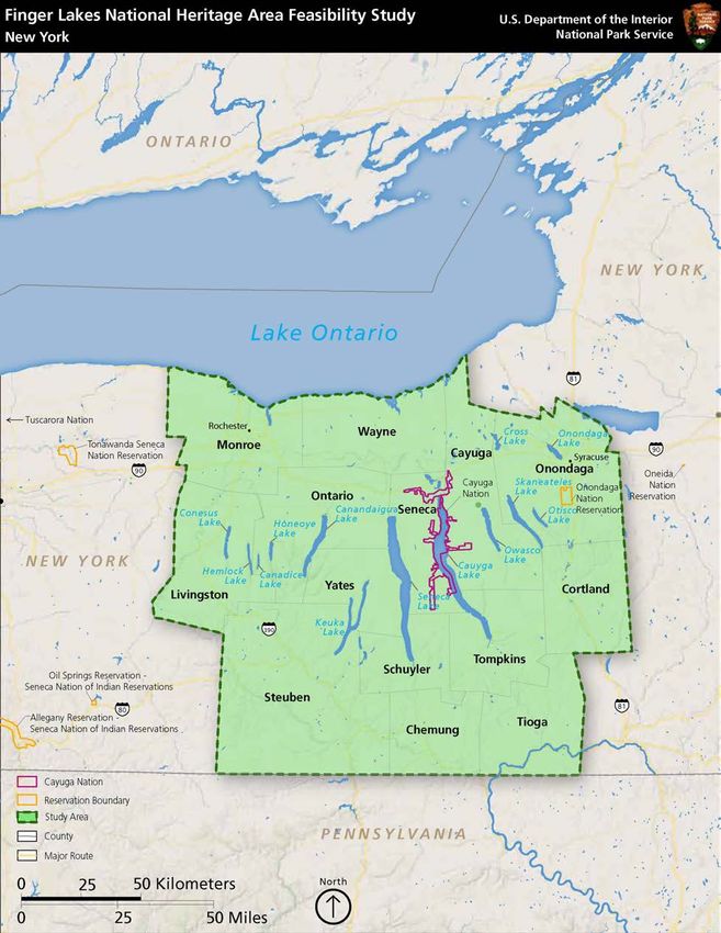
Figure 1. Finger Lakes Study Area ................................................................................................................... 2
iiiThis page intentionally blank.
ivCHAPTER 1 – INTRODUCTION
The John D. Dingell, Jr. Conservation, Management, and Recreation Act of 2019, Section 6003,
authorized the National Park Service (NPS) to conduct a study to assess the feasibility of designating
the Finger Lakes region of the State of New York as a National Heritage Area, to be known as the
''Finger Lakes National Heritage Area." Through the legislation, Congress directed the Secretary of
the Interior to consult with state and local historic preservation officers, state and local historical
societies, state and local tourism offices, and other appropriate organizations and governmental
agencies, to conduct the study and identified the study area as including the New York State
Counties of Cayuga, Chemung, Cortland, Livingston, Monroe, Onondaga, Ontario, Schuyler,
Seneca, Steuben, Tioga, Tompkins, Wayne, and Yates, as well as any other areas of the state adjacent
to those counties with heritage aspects similar to those counties (figure 1).
The feasibility study will follow the 2019 NPS National Heritage Area Feasibility Study Guidelines.
These guidelines include ten criteria that are evaluated to determine feasibility and suitability of a
candidate area’s inclusion in the National Heritage Area (NHA) system. These criteria include
determinations on whether an area:
1. Has an assemblage of natural, historic, or cultural resources that together represent
distinctive aspects of American heritage worthy of recognition, conservation, interpretation,
and continuing use, and are best managed as such an assemblage through partnerships
among public and private entities and by combining diverse and sometimes noncontiguous
resources and active communities;
2. Reflects traditions, customs, beliefs, and folklife that are a valuable part of the national story;
3. Provides outstanding opportunities to conserve natural, cultural, historic, and /or scenic
features;
4. Provides outstanding recreational and educational opportunities;
5. Where the resources important to the identified theme or themes of the area retain a degree
of integrity capable of supporting interpretation;
6. Where residents, business interests, nonprofit organizations, and governments within the
proposed area are involved in the planning, have developed a conceptual financial plan that
outlines the roles for all participants including the federal government, and have
demonstrated support for designation of the area;
7. Whether the proposed management entity and units of government supporting the
designation are willing to commit to working in partnership to develop the heritage area;
8. Where the proposal is consistent with continued economic activity in the area;
9. Where a conceptual boundary map is supported by the public; and
10. Where the management entity proposed to plan and implement the project is described.
The initial step in the NHA feasibility process is to document the historic and natural context of the
study area and to identify the presence of nationally significant themes that can be evaluated against
the NHA criteria (particularly criteria 1 through 5). The following report documents the National
Park Service’s initial attempt to capture this history and identify the themes of national importance
for the region. It is intended for review by the legislated consulting parties and other organizations
and agencies such that their comments and recommendations may be incorporated into the study
process at an early stage.
1Figure 1. Finger Lakes Study Area
2CHAPTER 2 – FINGER LAKES STUDY AREA NATURAL HISTORY
AND HISTORIC CONTEXT
GEOLOGIC FORMATION OF THE FINGER LAKES
Approximately 600 million years ago, during the Neoproterozoic Era, the Earth’s supercontinent
began to break apart, and an ocean formed between land masses that roughly correlate to Europe
and North America today. For the next 100 million years, this ocean continued to widen until the
continents changed course and began to move back towards each other. The eventual collision of
these land masses formed a tall mountain range now known as North America’s Appalachians. For
several hundred million years, the land mass to the west of the mountains was low and the ocean
regularly flooded the region, creating a broad shallow sea. The shallow water resulted in a high
evaporation rate that left behind thick salt deposits that are mined today across central New York. 1
During the Paleozoic Era, which began 542 million years ago and ended about 251 million years ago,
the earth’s sea level rose. The area now known as the Finger Lakes region was then near the equator,
and marine life thrived on the ocean floor. Layers of skeletal remains of these bottom-dwellers piled
up on the seafloor, forming a layer of mud that eventually became limestone. The Appalachian
Mountains continued to erode, sending gravel, sand, and mud into the shallow sea and eventually
forming the thick stack of sedimentary rocks of the Devonian age across Central New York. The
more coarse-grained sediments piled in deltas and beaches closer to the land to form the sandstone
layers found in the region today. The finer-grained sediments stayed suspended longer and moved
farther west, eventually settling out and forming the siltstone and shale layers found in the region.
Around 360 million years ago, the sea level fell and the land in what is now the Finger Lakes region
became dry. By about 240 million years ago in the Age of the Dinosaurs, the continents were again
joined as one. Evidence of dinosaurs in the region is almost nonexistent as a result of weathering and
bulldozing by the glacial ice sheets that followed. 2
The Finger Lakes themselves formed during the Pleistocene glaciation “Ice Age” when the first of
numerous continental glaciers up to two miles thick moved southward from the Hudson Bay area.
The advances and retreats of these massive glaciers grounded, polished, and scoured bedrock and
widened and deepened existing river valleys that would one day become the Finger Lakes. Around
19,000 years ago, the climate started warming and the glaciers began retreating, disappearing entirely
from the state around 11,000 years ago. 3 Deposition of glacial debris and sediment from erosion
contributed to the region’s distinctive landforms including:
• erratics—rocks dropped far from their origin by melting glaciers;
• till—a dense, mix of clay, gravel, and boulders mixed by glacial movement and melt;
• drumlins—hills composed of till that are characteristically steeper in the direction that ice
flowed; and
• eskers—narrow ridges created by streams flowing on the surface of a glacier;
1 James Dake, Field Guide to the Cayuga Lake Region (Paleontological Research Institute, 2009); Chris Clemes, “The
Story of Syracuse Salt,” Exploring Upstate, June 28, 2018, https://exploringupstate.com/story-syracuse-salt/.
2 Dake, Field Guide to the Cayuga Lake Region; O.D. von Engeln, The Finger Lakes Region: Its Origin and Nature
(Cornell University, 1988).
3 Scott C. Monje, “Finger Lakes,” Encyclopedia of New York State (Syracuse University, 2005), 561; Engeln, The Finger
Lakes Region.
3• kettle lakes—formations created where blocks of ice that broke off from a glacier were
buried by sediment and ultimately melted; and
• moraines—ridges created along the edge of ice by till or debris that mark the end of an ice
sheet. 4
The Valley Head Moraine crosses what is now central New York and is most visible as a boulder
field and kettles between the cities of Ithaca (Tompkins County) and Spencer (Tioga County). This
moraine plugged north-south flowing streams, allowing glacial melt to collect in the deep ravines
carved by pre-glacial rivers and to create the unusually deep and narrow Finger Lakes. 5 The moraine
also marks the divide between north-flowing rivers—remnants of the Ice Age stream and glacial
paths—and south-flowing rivers that run through Pennsylvania and drain into the Chesapeake Bay.
Glacial movement also created the gorges and waterfalls near the southern ends of the lakes. As
glaciers widened and deepened preexisting north-south river valleys by hundreds of feet, secondary
east-west streams running across ice flows were left relatively unaltered. This created the dramatic
cliffs and drops that are still associated with Watkins Glen (Schuyler County) and Ithaca (Tompkins
County). 6
EARLY INHABITANTS
According to archeological records, groups of nomadic Paleo-Indians travelled through the Finger
Lakes region approximately 8,000 to 9,000 years ago. Small bands of these hunter and gatherers
followed large game during the last stages of the Ice Age when the glaciers that formed the area’s
notable lakes were receding. Somewhat more recent early archaic archeological sites scattered
across western New York reflect a culture that was highly mobile and left little in terms of an
archeological record.
The Lamoka archeological site provides the bulk of information currently known about the
prehistoric inhabitants of the Finger Lakes region. When it was first professionally excavated in the
1920s, the site—located between Lamoka and Waneta Lakes in Schuyler County—provided some of
the first archeological evidence of late-Archaic hunters and gatherers in the Northeastern United
States. These early inhabitants lived in western New York between approximately 2,500 and 3,000
BCE and represent a distinct archeological culture between the early Archaic bands of hunters that
first traveled in the area and the following Woodland cultures notable for settlements and use of
pottery. They primarily settled by streams or near bodies of water, supplementing their diets with
fish. 7 The Lamoka archeological culture is defined by narrow, stemmed Lamoka points—projectile
points that would have been used as atlatl dart points, polished stone adzes, and bone tools. 8 The
4 Laurel Wemett, “Geological Historic and Glacial Formation of the Finger Lakes,” Life in the Finger Lakes, Summer
2001, https://www.lifeinthefingerlakes.com/geological-history-and-glacial-formation-of-the-finger-lakes/.
5 Timothy McDonnell, “The Finger Lakes Region,” Geography of New York State,
http://www.nygeo.org/fingerlakes2.html.
6 New York State Parks, Recreation, and Historic Preservation, “Watkins Glen State Park,”
https://parks.ny.gov/parks/142/.
7 Richard L. McCarthy and Harrison Newman, “Prehistoric People of Western New York,”
http://bechsed.nylearns.org/pdf/low/Prehistoric%20People%20of%20Western%20New%20York.pdf.
8 Walter Gable, “Chapter One-Original Inhabitants and the Iroquois,” Written History of Seneca County, New York,
https://www.co.seneca.ny.us/wp-content/uploads/2014/11/Chap-1-Original-Inhabitants-the-Iroquois-ADA.pdf
4Lamoka site is considered one of the most important precontact archeological sites in North
America for defining the Archaic cultural stage of the eastern United States as a whole. 9
By the Woodland period, approximately 500 BCE, the Lamoka were part of the Hopewellian trade
network that extended from present-day New York west into the Ohio River Valley and south to the
Gulf of Mexico. Hopewellian groups exhibited regional variances but are primarily identified by
their development of pottery, their shift toward agriculture and community life, and their creation of
monumental burial mounds, some of which are present in the Niagara Region of western New York.
During the mid- to late-Woodland period, the Owasco culture emerged as the predominant regional
group in what is now New York State. The Owasco period is associated with highly developed
religious rites and complicated art in the form of rimmed, round-based pottery and pipes in the
forms of animal and human faces. 10 The Roundtop archeological site in Broome County dates to the
Owasco period and provides insight into the lives of the people living in the Upper Susquehanna
River Valley approximately 700 to 900 years before present time. Features excavated at the site
contained the first evidence of cultivation of beans in the American Northeast, as well as the oldest
example of the corn-beans-squash growth triad that would become the foundational crops for
farming cultures across the region. 11 Evolutions in housing hint at an increase in population as well
as increases in hostilities between groups. During the late Woodland period, houses gradually shifted
from round huts to larger structures, some of which were protected by stockades. These practices
demonstrate an entrenched tradition relating settlement and complex ritual by the Finger Lakes
region’s indigenous inhabitants that extends from the Archaic, through Owasco, and into
contemporary times. Considering the material culture and archeological artifacts from the Finger
Lakes that date to the late Woodland (1100 CE), it is likely that the Owasco are the ancestors to the
present-day Haudenosaunee People historically associated with the state of New York. 12
HAUDENOSAUNEE CONFEDERACY AND LENAPE INDIAN NATIONS
[This section may be changed pending content to be received from Indian Nations, at their
discretion, through the ongoing formal Tribal Consultation process being conducted with the
National Park Service pursuant to the 2012 US Department of the Interior’s Policy on Consultation
with Indian Tribes, Section VII.A.]
The Haudenosaunee (“People of the Longhouse”) refer to themselves as Ongweh’onweh (“real
human beings”). By the European Colonial period, the confederacy between the Nations in present-
day New York was one of the best known among indigenous North American societies and the
strong pollical alliance is one of the hallmarks of Haudenosaunee society that continues into present
day. Oral tradition tells of a Peacemaker sent by the Creator during time immemorial to unite the
people and spread Kariwiio (“good mind”) throughout the Haudenosaunee territory. Peacemaker,
aided by Aiionwatha, commonly known as Hiawatha, traveled across the landscape to ask Nations to
unite as one government and create a Great League of Peace. The Mohawk, Oneida, Cayuga, Seneca,
and Onondaga—all still recognized Nations today—accepted this message of unity, and the
Peacemaker planted a Great Tree of Peace where all issues of the confederacy could be discussed.
Great White Roots extended in each direction from the tree, and the Peacemaker said any Nation
10 Richard L. McCarthy and Harrison Newman, Prehistoric People of Western New York, 10.
11 John P. Hart, “Dating Roundtop’s Domesticates: Implications for Northeast Late Prehistory,” in Current Northeast
Paleobotany: New York State Museum Bulletin 494 (1999), 47–69.
12 Richard L. McCarthy and Harrison Newman, Prehistoric People of Western New York, 10.
5that wanted to live by the Great Peace would be welcome in the shade of the tree. As a sign of
strength, the Peacemaker took one arrow from each of the Nations and bound them together,
symbolizing the unity of the Five Nations and the Confederacy’s power; he then explained to the
Nations’ leaders the laws of the Great Peace—Reason, Righteousness, Justice, and Health. 13 As
described below, the Tuscarora Nation became the Sixth Nation in the Confederacy in 1722.
The Haudenosaunee Confederacy is one of the earliest examples of a formal, diplomatic confederacy
and remains the oldest governmental institution in North America maintaining its original form. The
designated authority and balances of power exemplified in the Great Peace and Haudenosaunee
Confederacy, also referred to as the Iroquois Confederacy in the past, is considered the inspiration
for the United States (US) branches of government as outlined in the Constitution. 14 A congressional
concurrent resolution on September 16, 1987, acknowledged “...the historical debt which the Republic
of the United States of America owes to the Iroquois Confederacy and other Indian nations for their
demonstration of enlightened, democratic principles of Government and their example of a free
association of independent Indian nations.” 15
Politically united in peace, the Five Nations speak distinct languages and still maintain traditional
lands and territory within the Finger Lakes region. The Mohawk (Kanien’kehaka, “People of the
Flint”) were considered warriors and are known for their military prowess. They are known as the
“Keepers of the Eastern Door,” responsible for defending the eastern reaches of the Confederacy
that stretch into the Mohawk Valley. The Oneida (Onayotekaono, “People of the Standing Stone”)
hold territory directly east of the Finger Lakes. The Onondaga, (Onungdagano, “People of the Hills”)
historically have their territories near Onondaga Lake by present-day Syracuse. The “Keepers of the
Central Fire,” the Onondaga remain in the traditional political and geographic center of
Haudenosaunee territory and are known as storytellers and wampum keepers of the Confederacy.
The Cayuga (Guyohkohnyoh, “People of the Great Swamp”) were “little brothers” of the
Confederacy, and their ancestral territories are by the marshy north end of Cayuga Lake. They are
known as a farming people that also hunted waterfowl and fished. They often allied with the larger
neighboring Seneca nation. The “Keepers of the Western Door” of the Confederacy, the Seneca
(Onondowahgah, “People of the Great Hill”), as with the Mohawk for the East, were responsible for
defending the western portion of Haudenosaunee territory, which extends west through the
Genesee Valley to Lake Erie and southwest into Ohio Country.16
Besides sharing the Great Peace, Nations in the Confederacy were further united by cultural
similarities and familial connections. The Nations are matriarchal with membership passing through
the mother’s line of descent and women holding a place of power through their direct connection to
the Nations’ most important resources—members and agricultural crops. Women were largely in
charge of the political and social life, and individuals identify their community connections through
their mother’s family group, called clans. Clan mothers, usually the oldest woman in the clan, make
all major decisions for the clan and nominate the male leader of the clan, Hoyaneh (“Caretaker of
Peace”). Traditionally, men hunted and fished, while women gathered native plants and gardened.
Three main crops—corn, beans, and squash—were the foundation of the Haudenosaunee diet and
13 “Confederacy’s Creation,” Haudenosaunee Confederacy,
https://www.haudenosauneeconfederacy.com/confederacys-creation/.
14 National Museum of the American Indian Education Office, “Haudenosaunee Guide for Educators,” 3.
15 US Congress, Senate, Select Committee on Indian Affairs, A Concurrent Resolution to Acknowledge the Contribution
of the Iroquois Confederacy of Nations, 100th Cong., 1987, 8, https://www.govinfo.gov/content/pkg/CHRG-
100shrg83712/pdf/CHRG-100shrg83712.pdf].
16 National Museum of the American Indian Education Office, “Haudenosaunee Guide for Educators,” 1.
6considered to be divine gifts. When planted together, these three plants support each other through
the growing process in a mutually beneficial ecological process that earned them the name of the
Three Sisters. 17
The longhouse is a characteristic feature of historic Haudenosaunee settlements, and large
settlements would consist of multiple buildings. The large homes, which could measure as large as
120 feet long and 20 feet wide, were typically shared by approximately 60 extended family members.
Longhouses were the center of communal life and featured shared cooking spaces and sleeping areas
segmented into smaller family units by wood screens. Permanent Haudenosaunee settlements could
include hundreds of structures, and communities only relocated when supplies of firewood and
bark—material necessary for longhouse roof and wall repairs and lashing—were exhausted.
South of the Haudenosaunee lived the Lenni-Lenape, which translates to “Original People” in
Munsee Algonquin. The Lenape people—also called the Delaware Indians by European settlers—
lived in Lenapehoking (“place where the Lenape live”) in what is now southern New York, eastern
Pennsylvania, New Jersey, and Delaware, along “the River of Human Beings” (Delaware River). 18
The Lenape people are considered the “grandfathers” of the Algonquin Nations since they have
been connected to the Delaware River Valley more than 10,000 years and are the ancestors of many
East Coast Nations. The Lenape likely competed for resources and traded with their northern
neighbors, the Haudenosaunee, and intermarriages sometimes occurred, but the Nations’ histories
were characterized by wary relations that sometimes resulted in periods of warfare.
The Lenape Nation consisted of three clans, identified by their distinct dialects. The Munsee
(“People of the Stony County”) lived near the headwaters of the Delaware River in the northern
portion of Lenapehoking. The Unami (“People Down River”) were in the central part of the Lenape
Territory and the Unlatching (“People Near the Ocean”) extended toward the Delaware Bay. Theses
clans were further divided into matriarchal subclans and organized into matrilocal family groups. 19
Under this system, Lenape women would marry men from one of the other subclans, but any
children would become members of the mother’s clan, with their maternal male relatives taking on
most of the male child-rearing responsibilities. Because spouses were members of different social
groups, they maintained separate and equal rights and bore the individual responsibilities of
property and debts. 20 The Lenape, like the Haudenosaunee, cultivated the Three Sisters and used
fire to supplement the productive life of their fields.
EUROPEAN CONTACT
During the Age of Colonization, the Lenape people ruled the mid-Atlantic seaboard and were some
of the first people to meet explorers navigating Hudson Bay in the 1500s and built relationships with
early European colonists establishing New Amsterdam and New Sweden (present-day New York
City and Delaware) during the early 1600s. William Penn also wrote of his interactions with the
17 “Family Structure,” Haudenosaunee Confederacy, https://www.haudenosauneeconfederacy.com/historical-life-as-
a-haudenosaunee/family-structure/; “Housing,” Haudenosaunee Confederacy,
https://www.haudenosauneeconfederacy.com/historical-life-as-a-haudenosaunee/housing/;
18 Nanticoke Lenni-Lenape Tribal Nation,” Our History,” https://nlltribe.com/our-history/; Lenape Nation of
Pennsylvania, “About the Lenape Nation of Pennsylvania,” https://www.lenape-nation.org/
19 William A. Pencak and Daniel K. Richter, eds., Friends and Enemies in Penn’s Woods (University Park: Pennsylvania
State University Press, 2004).
20 Margaret M. Caffrey, "Complementary Power: Men and Women of the Lenni Lenape." American Indian
Quarterly. 24 (1): 44–63.
7Lenape in what is now Pennsylvania during the 1680s. Penn’s colony and Dutch settlement
around the mouth of the Hudson River began the displacement of the Lenape that continued into
the 1700s. 21
Farther north near the Great Lakes, the Onondaga Nation allowed Jesuit priests to develop missions
near their main village when French explorers and missionaries entered the area around present-day
Syracuse during the 17th century. Hostilities between indigenous nations allied with Samuel de
Champlain and the Mohawk as early as 1605 turned the Haudenosaunee Confederacy against the
French in North America. The 17th century was marked with periods of violence between the
French, their Native allies, and the Haudenosaunee member nations including King William’s War
(1689–1701), during which a French expedition destroyed the main Onondaga village near
Onondaga Lake. 22
The Confederacy’s wide-reaching political influence, vast geographic territory, and control over
waterways and trade routes throughout present-day New York and Canada made them valuable
trading partners and major players in the North American fur trade. These economic relationships
were first forged with the Dutch who settled New Amsterdam east of the Hudson River, occasionally
with the French during tenuous times of peace, and after 1660, with the English who took control of
Dutch claims in North America. Unfortunately, interaction with European colonists introduced
diseases that decimated the Confederacy’s population. By the 1660s, all the Haudenosaunee Nations
suffered major epidemics. 23 The Haudenosaunee embraced adoption of individuals or other groups
to “strengthen the longhouse” under the Great Peace. Bringing people into the long house helped to
solidify alliances and enhance indigenous solidarity during a time of great confusion and upheaval.
A key example of this is the inclusion of the Tuscarora nation, an Iroquoian speaking sister tribe
from the Carolinas, as the Sixth Nation in the Confederacy in 1722. The Tuscarora were forced to
travel north after being pushed out of their historic territory by British troops and mercenaries and
sought refuge among the politically strong Haudenosaunee, ultimately being adopted by the
Oneida Nation. 24
As tensions increased between England and France in North America during the 1700s, both nations
courted the Haudenosaunee as potential allies. Sir William Johnson, the British Superintendent of
Indian Affairs and a trusted friend of the Six Nations, helped secure Haudenosaunee support for the
British by mid-century. This translated into aid for the British on expeditions against France, a
relative degree of safety for British settlements in the region, and an eventual British victory over
France in the French and Indian War (1754–1763). 25 In the aftermath of the war, British settlers
pushed west and increasingly settled on Haudenosaunee land even though the Treaty of Fort
Stanwix (1768) signed by Britain and the Six Nations clearly delineated the boundary between
English and Indian land. 26
21 William A. Pencak and Daniel K. Richter, eds., Friends and Enemies in Penn’s Woods (University Park: Pennsylvania
State University Press, 2004).
22 “Onondaga Nation,” Encyclopedia of New York State, 1149.
23 “Oneida Early Historical Background - The Ancestors on the Oneida,” Milwaukee Public Museum,
https://www.mpm.edu/content/wirp/ICW-168.
24 “Oneida Life Ways,” Explore Oneida, https://exploreoneida.com/culture-and-history/oneidas-way-of-life/.
25 William Sawyer, “The Six Nations Confederacy During the American Revolution,” Fort Stanwix National
Monument, https://www.nps.gov/fost/learn/historyculture/the-six-nations-confederacy-during-the-american-
revolution.htm#CP_JUMP_3550115.
26 Michael Leroy Oberg, “American Indians: Colonial Period,” Encyclopedia of New York State, 66–67.
8AMERICAN REVOLUTIONARY WAR
Initially, the Haudenosaunee Confederacy claimed neutrality during the conflict between Britain and
the colonists, seeing the disagreement as a civil war and valuing loyalty to their families and to their
lands above all else. 27 When the political discontent erupted into the American Revolutionary War,
the member nations of the Haudenosaunee Confederacy split their support between the British and
newly formed American forces. The majority of nations and individual members supported the
British under the belief that those nations would be more likely to keep their relative independence
and land under continued British rule, while the Oneida and Tuscarora backed the American
Colonists. As with many American families, alliance was not clear-cut, and in some cases, allegiance
was split on a person-by-person basis, which destabilized the clan-based society. What had started as
a European civil war on North American soil soon turned the Confederacy against itself,
undermining the social unity and political stability that the Six Nations had enjoyed for centuries.
In 1778, Loyalists and members of the British-backed nations participated in destructive raids that
crippled Continental forces and destroyed frontier settlements in New York and Pennsylvania.
Fearing that the New York frontier would be pushed east to the Hudson River if divisive action was
not taken, General George Washington ordered General John Sullivan to lead four brigades of
men—a sizable portion of the Continental Army—on a scorched-earth campaign that would limit the
Haudenosaunee’s ability to attack in the future. Washington tasked Sullivan with launching a terror
campaign to destroy the food supply of the Cayuga and Seneca Nations in the heart of the Finger
Lakes and to reduce the Cayuga and Seneca’s forces. Smaller expeditions were tasked with
destroying Seneca settlements in western Pennsylvania and Onondaga settlements in central
New York.
In August 1779, forces led by General Sullivan and his second-in-command, General James Clinton
met in Tioga near the Pennsylvania-New York border and began their campaign by destroying the
Munsee Delaware settlement of Chemung in present-day Chemung County. 28 Instead of deploying
the guerrilla tactics that long served Haudenosaunee well, Confederacy war chiefs and the meager
British forces available to counterattack decided to retaliate with a standing battle. The Battle of
Newtown on August 29, 1779, ended in a British and Indian retreat and destroyed morale for the
British-backing Confederacy Nations, who now chose to proactively flee to other nearby
settlements. For the next two weeks, Sullivan’s forces moved from Seneca Lake to Canandaigua Lake
to Chenussio—a Seneca stronghold near present-day Leicester in Livingston County that included
128 multi-family longhouses. By the end of the campaign, Sullivan’s men destroyed more than 40
Haudenosaunee villages, at least 160,000 bushels of corn, countless pounds of stored vegetables and
fruit, and only suffered 40 casualties.
While the American forces did not take Haudenosaunee prisoners, the Sullivan Campaign destroyed
the nations’ capacity to wage war. By the end of September 1779, more than 5,000 nation members
had arrived at the British Fort Niagara expecting food, clothing, and shelter in the face of their
27“Tribal History,” Cayuga Nation, http://cayuganation-nsn.gov/tribal-history.html.
28James Folts, “The Munsee Delawares of Chemung/Wilawana in the Revolutionary War Era,” Binghamton
University Public Archaeology Projects-Chemung Battlefield Project, 2020,
https://www.binghamton.edu/programs/public-archaeology-facility/projects/chemung-battlefield/historical-
perspectives.html.
9catastrophic losses at the hands of the Americans. 29 Instead of lessening the threat to frontier
settlements, the Sullivan Campaign increased the animosity of Natives and British alike, laying the
ground for fierce fighting within the New York frontier of British-backed Indian raids during the
1780s.
AMERICAN EXPANSION INTO INLAND NEW YORK
The Treaty of Paris of 1783 officially ended hostilities between the British and Americans; however,
the treaty did not include the allied Indian Nations, leaving their legacy treaties with the Europeans
unresolved and their future to be resolved through separate treaties with the new American
government. The 1784 Treaty of Fort Stanwix, which was signed by Six Nations representatives but
never ratified by the US Congress, ceded interests in land west in Ohio Country and north of the
boundary negotiated with Britain during the previous treaty at Fort Stanwix to the United States. 30
Many Cayuga and Seneca who backed Britain and lost everything during the Sullivan Campaign had
already moved to Canada following the Sullivan-Clinton Campaign. 31
Immediately following the war, states in the newly created United States competed for control of
lands formerly part of the Indian frontier. The 1786 Treaty of Hartford delineated the boundaries of
New York and Massachusetts, states that had both laid claims to land extending west of Seneca Lake
and running from the shore of Lake Ontario to the Pennsylvania border. The newly minted states
agreed to split rights to the contested territory, recognizing the land as part of New York State but
granting Massachusetts preemptive rights to negotiate with the Six Nations for clear title to the land
that includes the Finger Lakes. Speculators quickly purchased rights to titles containing large swaths
of western New York from Massachusetts and negotiated with tribes for rights. The Phelps and
Gorham Purchase of 1788 covered six million acres of land west of Seneca Lake including the
present-day counties of Ontario, Steuben, Yates, and portions of Monroe, Livingston, Wayne, and
Schuyler. The parcel was quickly subdivided and sold to interested New Englanders looking to
spread out and create new settlements and farms.
New York also promoted post-war settlement in the newly opened western portion of the state
through its development of the nearly two million-acre Central New York Military Tract. The
Continental Congress promised men who volunteered for service with the Continental Army 100
acres of land for their service; facing a shortage in volunteers, New York upped the offer to 600 acres
per man. In 1789, after formalizing which lands were included in the newly established Cayuga and
Onondaga reservation, the state established 25 townships in the eastern Finger. Each township was
comprised of 100 lots of 600 acres and was given a classical name borrowed from Ancient Greece or
Ancient Rome. 32 Haudenosaunee homeland and traditional names were replaced with names
considered appropriate for a young nation guided by Enlightenment principles: “Aurelius,” a Roman
Emperor; “Cincinnatus,” the farmer and leader that inspired first president George Washington;
“Homer,” the blind, Greek poet who authored The Iliad and The Odyssey; “Ovid,” the ancient poet
29 Fort Stanwix NM Staff, “The Clinton-Sullivan Campaign of 1779,” Fort Stanwix National Monument,
https://www.nps.gov/fost/learn/historyculture/the-western-expedition-against-the-six-nations-1779.htm; Joseph R.
Fischer, “Sullivan-Clinton Campaign,” Encyclopedia of New York State, 1503.
30 Fort Stanwix NM Staff, “Treaty and Land Transaction of 1784,” Fort Stanwix National Monument,
https://www.nps.gov/fost/learn/historyculture/treaty-landtransaction-1784.htm.
31 Michael Leroy Oberg, “American Indians: Colonial Period,” Encyclopedia of New York State, 67.
32 Bernie Corcoran, “Military Tract of Central New York,” Town of Sennett, New York,
https://www.cayugacounty.us/918/Military-Tract-of-Central-New-York; Peter Eisenstadt, “Military Tract,”
Encyclopedia of New York State, 1048.
10regarded the master of Latin language; “Romulus,” one of the legendary founders of Rome;
“Virgil,” the Roman poet who penned the Aeneid; and “Ithaca,” home of the Greek hero Ulysses;
among others.
To curb unbridled speculation of Indian territory, the US Congress passed the Indian Intercourse
Act of 1790 to stop states from sanctioning ruthless pursuit of Indian land. However, distribution of
Haudenosaunee land as military allotments continued. Land in the present-day counties of Cayuga,
Cortland, Onondaga, Seneca, and portions of Oswego, Tompkins, Schuyler, and Wayne were offered
for purchase starting in 1791. The Haudenosaunee Confederacy Nations appealed to the President
and Congress to curb speculation, and to avoid further and prolonged conflict with the Native
nations in New York, signed the 1795 Treaty of Canandaigua, which is still celebrated and
recognized today. This treaty, one of the first signed by the young United States as a nation, affirmed
Haudenosaunee land rights greatly reduced the land within the military tract but restricted the
Haudenosaunee Nations from making future land claims. With the treaty in place, the State of New
York finalized arrangements for distribution of the Central Military Tract plots in 1799. However,
because of the delay between the end of the Revolutionary War and lot distribution, the majority of
military tract lands were purchased by private New York and New England speculators, forcing
Congress to reserve further rights for the federal government to regulate Native commerce
and trade.33
Soldiers who took part in the Sullivan Campaign remembered the favorable nature of the area and
agricultural potential of the land that was previously occupied by the Haudenosaunee and eagerly
entered the lottery for military tracts or moved west to stake claims from speculators. Heavy forests
covered the majority of the Finger Lakes, providing ample timber and potash created from ashes of
burned logs—two profitable products at the turn of the 18th century. With the Indigenous
population either violently pushed out of the region or sequestered onto reserved lands, many early
American settlers created small farms that took advantage of the region’s nutrient-rich soil and
relatively moderate climate, side effects of the glacial movement that created the Finger Lakes and
their surprising depths. The invention of a cast iron plow with standard, interchangeable parts,
patented in 1819 by Jethro Wood, an early white resident of Ledyard (present-day Cayuga County),
revolutionized agriculture and improved farmers’ efficiency across the young country. 34 Some of the
earliest Western New York settlements including Auburn (present-day Cayuga County), Ithaca
(present-day Tompkins County), Geneva (present-day Ontario County), and Canandaigua (present-
day Ontario County) were founded in the early years of the 19th century at locations that highlight
the region’s blend of natural resources, ample waterpower, and agricultural potential. 35
Expansion of the western frontier also attracted religious groups eager to build communities outside
18th-century societal norms. The evangelist group The Public Universal Friend and their followers
were some of the first settlers in the Genesee Valley, coming into the area during the late 1780s. Born
Jemima Wilkinson and raised in a Quaker household, The Friend adopted androgynous dress,
shunned gendered pronouns, and preached a doctrine of free will and universal salvation that valued
individuals regardless of gender or race. The Society of Universal Friends first created the settlement
33 Anne M. Derour, “Seneca County,” Encyclopedia of New York State, 1390.
34 “Jethro Wood House,” National Historic Landmark Form (Washington D.C.: Department of the Interior, National
Park Service, 1976)
35 Scott C. Monje, “Finger Lakes,” Encyclopedia of New York State, 561.
11of Gore and then moved to the town of Jerusalem (Yates County). By 1790, the community was the
largest non-Native settlement in Western New York and included approximately 260 people—
almost 1/5 of Western New York’s white inhabitants. 36
The Religious Society of Friends, commonly known as the Quakers, looking to create communities
of religious acceptance and equality, also found a place in central New York. Two Massachusetts
Quaker families purchased land from Phelps and Gorham in the 1780s. In 1789, with a group
purchasing an entire 25,000-acre township in what is now Ontario County. More Pennsylvania
Quakers arrived in the Finger Lakes area shortly after the Treaty of Canandaigua was ratified in
1795 to support the Haudenosaunee and enforce the nations’ treaty rights in the face of
Native displacement. 37
As more settlers moved into Western New York, the region’s many lakes gained importance as
transportation corridors. Cayuga Lake emerged as an early transportation route. The lake’s marshy
northern terminus was initially seen as a barrier to overland travel and settlement, but once a ferry
was introduced in 1788, settlers could easily navigate from Ithaca into the heart of the Finger Lakes
or continue their journey as far north as the Seneca River. 38 Turnpikes following established
Haudenosaunee inland routes connected the seemingly far-flung settlements popping up in the
Military Tract and Phelps and Gorham Purchase to the state capital region surrounding Albany.
Chartered by the state in 1800, the Seneca Turnpike—also called the Great Genesee Road and the
Iroquois Trail—ran 160 miles east-west through Canandaigua, Waterloo, Syracuse, Oneida, and
Utica north of the Finger Lakes and included the longest bridge in the world. 39 The Cayuga Bridge
spanning the northern end of the Cayuga Lake measured more than a mile long and aided overland
travel when it was completed in 1800. One of the largest public improvements in the young State of
New York, the bridge became a symbolic divide between the East and the newly opened West.40 By
1810, Ithaca was connected to Bath (Steuben County), Geneva (Ontario County), and the Seneca
River by plank roads, many of which were privately funded by Charles Williamson, the majority
investor in the one million-acre Pulteney Purchase that stretched from the falls of the Genesee River
(the present-day site of Rochester in Monroe County) to the junction of Genesee River and
Canaseraga Creek south of present-day Geneseo (Livingston County). 41
Steamboats rose to prominence during the 1820s, especially on the larger Finger Lakes such as
Cayuga, Seneca, and Keuka, as they provided additional transportation and connections to small
settlements spread around the lakes’ shores. Steamboats also supported the earliest recreational
development of the Finger Lakes, with the first excursion boat appearing on Skaneateles Lake
in 1816. 42
36 Paul B. Moyer, The Public Universal Friend: Jemima Wilkinson and Religious Enthusiasm in Revolutionary America
(Ithaca: Cornell Press, 2015), 133; Jemima Wilkinson House, National Register of Historic Places (Washington D.C.:
Department of the Interior, National Park Service, 1994)
37 Farming Quaker Crossroads Historic District, National Register of Historic Places (Washington D.C.: Department
of the Interior, National Park Service, 2007).
38 Scott C. Monje, “Finger Lakes Ferries,” Encyclopedia of New York State, 561.
39 Portions of modern New York Highway 5 in the Finger Lakes Region follow the Seneca Turnpike route.
40 Village of Cayuga, “History of Cayuga, https://www.villagecayugany.com/about-cayuga/.
41 Carol Kammen, “Tompkins County” Encyclopedia of New York State, 1565; James D. Folts, “The ‘Alien
Proprietorship’: The Pulteney Estate during the Nineteenth Century,” Crooked Lake Review, Fall 2003,
https://www.crookedlakereview.com/articles/101_135/129fall2003/129folts.html.
42 Scott C. Monje, “Finger Lakes,” Encyclopedia of New York State, 561; Patricia Blacker, “Skaneateles,” Encyclopedia
of New York State, 1415–1416.
12Early educational and religious institutions tried to tame the “frontier” and provide religious
guidance in the remote, but now accessible, inlands of New York that were first served by iterant
Methodist circuit riders trained in New England. Canandaigua Academy, a single-sex educational
institution offering a classical education, was charted in 1795, only a few years after the town of
Canandaigua (Ontario County) was selected as the land office of the Phelps and Gorham Purchase. 43
Geneva (Ontario County) became the headquarters of the New York Genesee Land Company in
1793 and the Geneva Academy was founded three years later. 44 Located along the only overland
road between Albany and Buffalo, the Auburn Theological Seminary Presbyterian was founded in
1818 by the Presbyterian Synod of Ontario and Seneca Counties to provide students with a
nondenominational Protestant education that would support ministry in the far reaches of the
expanded United States. 45
In 1817, the Auburn Penitentiary opened as the second prison in the state of New York. The
“Auburn System,” also called the “silent system” or “communal system,” forced convicts to walk
lock-step, wear striped uniforms, and silently work side-by-side in prison shops before returning to
solitary cells at night. Guards, who also stood silently overseeing the work, doled out harsh corporal
punishment for minor infractions. The revolutionary penal system made prisons profitable by
contracting out convict labor for nearby industries and reduced the threat of prisoner uprising or
riots by taking away prisoners’ voices; during the 1820s and 1830s, the prison’s success attracted
thousands of visitors a year who paid to view the penitentiary’s silent yards and shops. 46
CANAL ERA
As the population of interior New York increased, developers pushed for a faster method of
transportation between the area and developed population centers like New York City. The Erie
Canal, completed in 1825, revolutionized inland travel and ushered in a broader era of canal
construction across the state, connecting the state capital of Albany on the western shore of the
Hudson River to the western New York and the Great Lakes. The 363-mile artificial waterway
opened the New York interior to trade, transportation, and seemingly limitless economic
opportunities to communities along its path. The historic route ran south along Onondaga Lake at
Syracuse and grazed the north shore of Cayuga Lake before traveling through the northern portions
of Cayuga, Seneca, Wayne, and Monroe Counties along its path between the cities of Syracuse
and Rochester. 47
Farmers were now able to ship their fruits, vegetables, grains, and animals farther afield to markets
along the Eastern Seaboard. Canal development was quickly followed by water-powered flour mills,
cotton and wool mills, sawmills, paper mills, tanneries, and distilleries that helped transform the raw
products into additional goods to be shipped to larger cities and markets in the east. Rochester
became known as the “Flour City” because of its many flour mills powered by the waterfalls along
the Genesee River, and the connectivity provided by the Erie Canal allowed New York farmers to
43 Nancy Beadie, “Academies,” Encyclopedia of New York State, 6–7.
44 Marla A. Bennett, “Geneva,” Encyclopedia of New York State, 631.
45 Barbara G. Wheeler and Mark N. Wilhelm, “Auburn Theological Seminary,” Encyclopedia of New York State,
135–136.
46 Scott W. Anderson, “Auburn Correctional Facility,” Encyclopedia of New York State, 135; Cayuga Museum of
History and Art, “The Auburn System,” 2019, https://cayugamuseum.org/the-auburn-system/.
47 National Park Service, “History and Culture,” Erie Canalway National Heritage Corridor,
https://www.nps.gov/erie/learn/historyculture/index.htm; Roy G. Finch, “The Story of the New York State Canals,”
New York State Canal Corporation, http://www.canals.ny.gov/history/finch_history_print.pdf
13process their wheat in Rochester and ship it across the country. By the end of the 1830s, Rochester
was the third largest city in the state of New York. 48
Canals also allowed for cheaper shipping of heavy materials. Minerals from the glacial formation of
the region became some of the first products associated with the Syracuse area. Commercial salt
production boomed near the marshy south shore of Onondaga Lake as canal shipping made
transporting bulky cargo quicker and less expensive. Syracuse and other Onondaga County villages
economies were built around saltworks and related industries of firewood cutting, barrel
production, pump manufacturing, and pipe making. Pork became a popular commodity as inland
farmers preparing pork for shipping used salt produced around Syracuse. Limestone, an essential
product for plaster, cement, and fertilizer was also quarried in Onondaga County. 49
While the 1825-alignment of the Erie Canal bypassed the heart of the Finger Lakes, the second era of
canal building that was ushered in once developers saw the success of the Erie Canal created more
local connections to facilitate commercial opportunities and quicker trade. Opened in 1832, the 17-
mile Seneca-Cayuga Canal connected the northern portions of the two largest Finger Lakes along the
canalized Seneca River. 50 This extended canal shipping further hinterland to wheat growers and
farmers in Tompkins, Schuyler, Yates, and Ontario Counties and contributed to the development of
the communities of Seneca Falls, Waterloo, and Geneva. The Crooked Lake Canal, opened in 1833,
connected Keuka and Seneca Lakes and provided canal access to Penn Yan, Steuben County, and a
larger portion of Yates County. 51 The Chemung Canal ran south from Watkins Glen on the southern
tip of Seneca Lake along the Chemung River through Chemung County and into Pennsylvania,
providing a water route from coal country to Lake Erie. 52 The Genesee Valley Canal, built during the
1840s, ran south from Rochester and connected the Erie Canal to farmers and wheat growers in
inner Livingston County, bringing more grain to the Rochester mills. 53
Much like the commercial development that grew along the Erie Canal during the 1820s, processing
facilities, commercial centers, and increased transportation also developed along the smaller canals
connecting the Finger Lakes during the 1830s and 1840s. Steamboats towed barges full of timber,
milled goods, and coal across the Finger Lakes to access the Erie Canal, Great Lakes, and ultimately
larger markets, including New York City.
Along with economic opportunities, canals also provided traditional inroad for settlement. Besides
Binghamton and Elmira, every major city in New York State is located along a trade route established
by the Erie Canal. The Erie Canal became a major immigration route with more immigrants moving
westward along the Erie Canal corridor than any other trans-Appalachian canal. Close to 80% of
upstate New York’s population lives within 25 miles of the canal’s path. 54 Immigrants who first came
48 Carolyn Vacca, “Monroe County,” Encyclopedia of New York State, 999.
49 “Syracuse,” Encyclopedia of New York State, 1517.
50 Scott C. Monje, “Finger Lakes,” 561; Michael Riley, “Cayuga and Seneca Canal,” Encyclopedia of New York State,
289; “The Cayuga and Seneca Canal,” Seneca County, New York, https://www.co.seneca.ny.us/wp-
content/uploads/2014/11/Cayuga-and-Seneca-Canal-ADA.pdf
51 Gwen Chamberlain, “Yates County,” Encyclopedia of New York State, 1737-1738; Douglas B. McDonald, “Seneca
Lake,” Encyclopedia of New York State, 1393.
52 James D. Folts, “Steuben County,” Encyclopedia of New York State, 1479–1480.
53 William R. Cook, “Livingston County,” Encyclopedia of New York State, 914–915.
54 New York State Canal Corporation, “Canal History” http://www.canals.ny.gov/history/history.html.
14to central New York to build the canal settled in Syracuse, Rochester, and smaller towns that lined
the canal, creating ethnic neighborhoods associated with the Irish and German immigrants who
helped construct the canal. 55
SOCIAL AND RELIGIOUS MOVEMENTS
Central New York communities that flourished with canal-related development and rail connections
throughout the 19th century also became hotbeds for religious and social movements of the early
1800s as the area’s population rapidly grew. Religious freedom granted by the United States Bill of
Rights combined with rapid societal and technological changes experienced by Americans living
through western expansion fueled an American spiritual movement that was exemplified in the
newly opened frontier of New York. Between 1825 and 1835, Charles Grandison Finney—a
Presbyterian minister who embraced the emotional expression of faith that appealed to those living
on the American frontier and the concept of self-improvement and freewill—hosted large-scale
conversions and religious revivals throughout upstate New York. The recently opened Erie Canal
allowed for travelling preachers, including Finney, to easily reach new audiences in the state’s
interior. Rochester’s boomtown atmosphere drew Finney to the town in 1830. While there, he
preached six times a week and attracted thousands of individuals from the surrounding areas during
his winter Great Revivals, large-scale social and religious events that included mass conversions. 56
Religious fervor in central and western New York was so pronounced during the “Second Great
Awakening” of the 1830s and 1840s that the area was referred to as the “Burned Over District,” a
reference to the spiritual fire embodied by the various groups and the speed in which the movement
engulfed the area. 57
The Protestant Revival Movement shifted focus from congregations that relied on educated religious
leaders to interpret religious texts to a populist approach that put salvation into the hands of the
masses, exemplified in large-scale camp and revival meetings, mass conversions, and renewed
interests in personal interpretations of Christian religious texts. Throughout western New York,
more than 300 new congregations were created by 1845. 58 New American religions that were formed
in the Finger Lakes during this time include the Church of Latter Day Saints—started by Joseph
Smith, Jr. after he reportedly found golden plates inscribed by God in a field outside Palmyra (Wayne
County) and published their inscriptions in 1830 as the Book of Mormon—and Spiritualism, brought
to prominence by the Fox Sisters of Hydesville (Wayne County) during the late 1840s. 59 Utopian
communities based on the communal principles of French thinker Francois Marie Charles Fourier
appeared at Sodus Bay (Wayne County) and Skaneateles (Onondaga County) during the 1840s, but
55 Lorraine Boissoneault, “Thank the Erie Canal for Spreading People, Ideas, and Germs Across America,”
Smithsonian Magazine, July 3, 2017, https://www.smithsonianmag.com/history/grab-your-mule-named-sal-and-
explore-erie-canal-180963892/.
56 John H. Martin, “Charles Grandison Finney” in Saints, Sinners and Reformers: The Burned-Over District Revisited,
Crooked Lakes Review, 2005, https://www.crookedlakereview.com/books/saints_sinners/martin7.html.
57 “The Burned-Over District,” New York Heritage Digital Collection, 2020, https://nyheritage.org/exhibits/two-
hundred-years-erie-canal/burned-over-district.
58 “Burned Over District and its Reforming Zeal,” Chronicle Express, January 31, 2016, https://www.chronicle-
express.com/news/20160131/burned-over-district-and-its-reforming-zeal.
59 Ronald D. Cohen, “Wayne County,” Encyclopedia of New York State, 1670–1680; Church of Jesus Christ of Latter-
Day Saints, “Joseph Smith Family Farm,” https://history.churchofjesuschrist.org/subsection/historic-sites/new-
york/palmyra/joseph-smith-historic-farm-site?lang=eng; Stephanie L. Knarr, “A Celebration of 163 Years of Moderns
Spiritualism,” Wayne County Life, http://www.waynecountylife.com/2011/03/fox-sisters-by-stephanie-l.html.
15You can also read